


by David Moran, on May 3, 2018 2:59:07 PM
One of the jobs of a forecaster is to anticipate how the profile plotted on a Skew-T diagram may change with time and what implications that may have on a forecast. How winds change with height can be a significant factor in temperatures, precipitation type, and storm development.
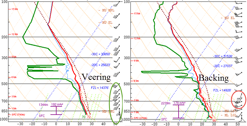
When the wind changes direction with height, it can be called either backing or veering, depending on the direction it turns. Winds that rotate clockwise with height are said to veer; wind turning counter-clockwise are backing. Winds that veer are associated with incoming warm air (advection), whereas winds that back suggest cold air advection. Both backing and veering winds can be present within the same sounding.
 Backing and Veering Winds
Recognizing backing and veering winds can have implications on a forecast in several ways. When forecasting winter precipitation, the change in wind can affect the temperature profile, and thus the precipitation type. For example, if a temperature profile favors freezing rain, cold air advection (backing winds) in the warm layer may allow precipitation to transition to sleet or snow. Warm air advection (veering winds) near the surface may mean the difference between freezing rain and just a cold rain. In forecasting thunderstorms, cooling of the mid levels of the atmosphere (consistent with backing winds) can increase instability, making an environment more favorable for storms.
Veering winds can also play a role in the development of thunderstorms, especially supercells. Strong veering of the winds from the surface to the mid levels of the atmosphere can cause a thunderstorm to rotate. A wind profile that is commonly found in association with supercells has southeasterly winds at the surface and westerly or southwesterly winds at the midlevels of the atmosphere. Not only is the directional change important, but also the speed of the winds. Typically, winds greater than 20 knots (about 23 mph) are required; the stronger the shear, the more likely a storm will become a supercell. Backing winds, on the other hand, are usually not associated with severe thunderstorm development.
While Skew-T diagrams can provide a wealth of information on the temperature profile of the atmosphere, the winds can provide additional information. Analyzing the winds and how they change with height can help you anticipate how temperatures throughout the atmosphere may change and whether storms will rotate. This information can be crucial in correctly forecasting precipitation type in the fall and winter, as well as thunderstorms in the spring and summer.
In the third and final blog of this series, we will look at how Skew-T diagrams can be used to assess the stability of the atmosphere and the potential for thunderstorm development.
