Tornado Warnings: Where we’ve been, and where we’re going
by Matt Gaffner, on Nov 18, 2015 11:40:44 AM
The first Tornado Warning was issued at Tinker Air Force Base in Oklahoma on March 25, 1948. Back then, the Tornado Warning was nothing more than passing on an observation of a tornado on the ground and where it was headed. Since then, we’ve come a long way. With the advent of Doppler radar in the 1980s, strong rotation could be identified and Tornado Warnings could be issued for entire counties. As radar data in the US became available in higher resolution and the tools used by the National Weather Service to issue Tornado Warnings were improved, the NWS developed the ability to refine Tornado Warnings by drawing polygon Tornado Warnings in 2007. This allowed the NWS to highlight and alert only parts of counties that are more likely to be impacted by a tornado. This greatly decreased the False Alarm Rate (FAR) and improved the public’s understanding of National Weather Service Warnings.
So, in the spirit of continual improvement on both the science and communication front, where are we going? Millions of research dollars are predicated on extending lead times. The NWS states that their average lead time is about 13 minutes. If you ask me, that’s plenty of time to seek appropriate shelter. In fact, I argue that too much lead time can be a bad thing. I know of a specific instance on April 3, 2012 when a tornado was moving slowly from Arlington, TX northeastward towards Coppell, TX (a north Dallas suburb). Schools in Coppell had over 30 minutes warning. There was a perception that a Tornado Warning required immediate action. After 5 minutes of huddling in an interior bathroom with no means of communication with the outside world, it was assumed that surely the storm had passed. Everyone got up and went back to class, only to return to shelter two more times before the dangerous part of the storm arrived at their location. Fortunately, when the supercell passed over Coppell it was no longer producing a tornado.
There was clearly a breakdown in communication. I argue that improving the communication of tornado risk will far outweigh the benefit of longer lead times. As far as the school was concerned, the Tornado Warning meant only one thing: take cover! But there was no information regarding how much time they had to seek shelter, or how long they should remain there.
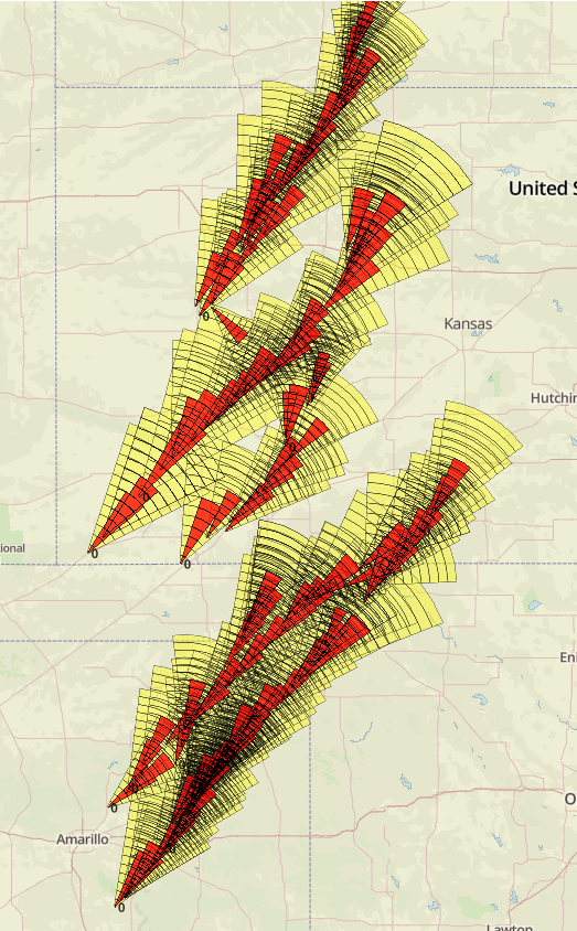
In order to take the guesswork out of Tornado Warnings, WDT is developing a new Tornado Warning methodology that we’re calling Tornado Vision. It will allow recipients of warnings from the Tornado Vision system to not only know that they are currently in the forecast path of a tornado, but how long they have until the tornado gets to their location out to 60 minutes. Using this methodology we can create a decision matrix advising people how to react. If you have 60 minutes, you have time to move some boxes in the garage so you can get the car in, and then take shelter. If you have 15 minutes, maybe you still have time to put the car in the garage, as long as you don’t have to move boxes. If you have 5 minutes, you better get in your shelter ASAP! The same logic applies to business continuity. With a predetermined decision matrix, the foreman at a large manufacturing plant can follow the prescribed process to get equipment shut down and people to a known shelter. Removing the burden of making decisions on the fly, especially during a high-stress severe weather event, will ensure that employees make the right decisions, reduce liability, and get to safety.
The image below shows all of the Tornado Vision warnings that were generated during the November 16, 2015 tornado event. The yellow parts of the polygons indicate a moderate threat, and the red polygons indicate a high threat of being impacted by a tornado. All of the sections as you move from the narrow part of the cone to the broad part of the cone indicate 5 minute periods of time.


