National Weather Summary for Wednesday, September 28, 2016
by David Moran, on Sep 28, 2016 12:07:41 PM
A cold front moving through the Ohio Valley on Wednesday will be the focus for thunderstorm development. Further east, thunderstorms are likely across the Mid Atlantic and Southeast as a warm front moves northward. Thunderstorms and heavy rainfall will continue across the Mid Atlantic and move into portions of the Northeast on Thursday as an area of low pressure remains nearly stationary. This heavy rainfall will continue across the Mid Atlantic on Friday.
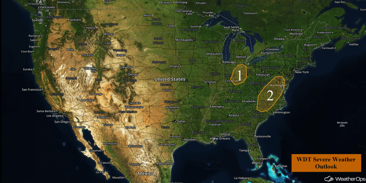
US Hazards
Region 1
A cold front moving through the region will act as a focus for shower and thunderstorm development on Wednesday. Modest instability in place could allow for a few thunderstorms to become strong, with small hail expected to be the main hazard. Thunderstorms that remain below severe limits will still be capable of producing frequent lightning and heavy rainfall. The most likely time for severe weather will be during the afternoon hours, with the threat diminishing during the evening.
Major Cities in Region: Fort Wayne, IN, Cincinnati, OH, Dayton, OH
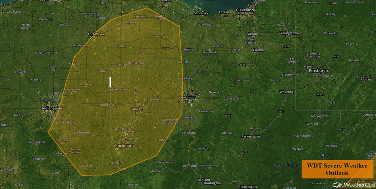
Region 1
Region 2
A warm front will move northward into the Mid-Atlantic today. Behind this warm front, very warm, moist, and unstable air will overspread the region. Given this large instability, combined with sufficient wind shear, thunderstorms that develop later today are likely to become supercellular. The main severe weather threat will be damaging wind gusts, with large hail also possible. A few tornadoes will be possible as well. The most probable time for severe weather will be during the mid-afternoon with the severe weather threat diminishing during the evening. In addition, heavy rain will be possible; rainfall amounts of 1-3 inches with isolated higher amounts in excess of 4 inches will be possible, leading to the potential for flash flooding.
Update 2:42pm EDT: Thunderstorms capable of hail and damaging winds have developed along the North Carolina/Virginia border.
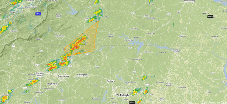
Radar 2:42pm EDT
Update 3:02pm EDT: Severe thunderstorms south of Raleigh, NC. Hail and damaging winds possible.
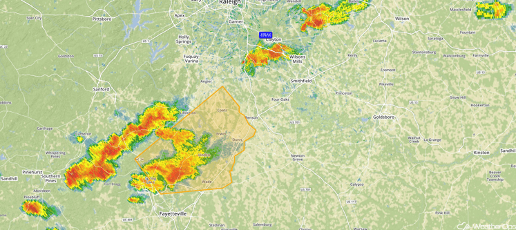
Radar 3:02pm EDT
Update 3:10pm EDT: Severe Thunderstorm Watch in effect for portions of Maryland, North Carolina, and Virginia until 10pm EDT. Hail to 1.5 inches in diameter, damaging winds to 70 mph, and isolated tornadoes will be possible.
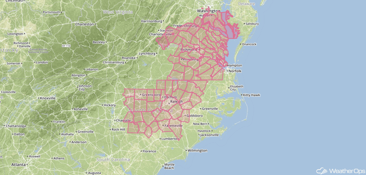
Severe Thunderstorm Watch
Major Cities in Region: Charlotte, NC, Raleigh, NC, Richmond, VA, Washington, DC, Baltimore, MD
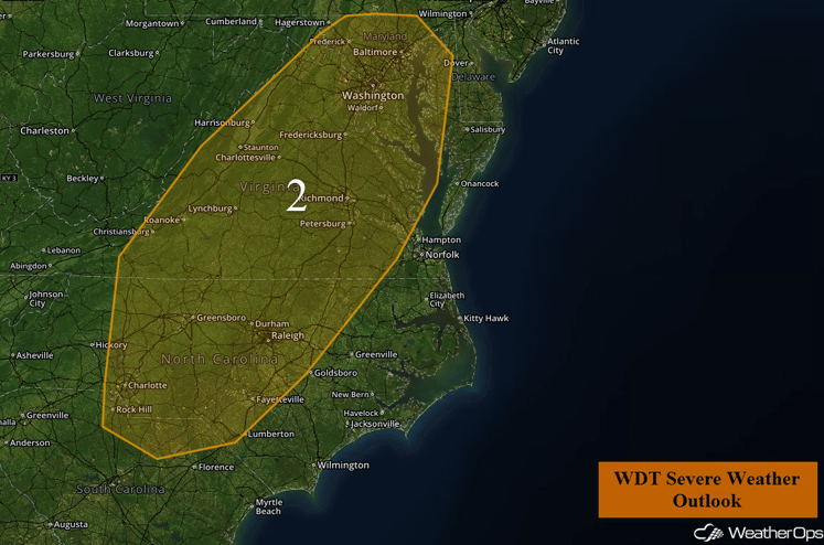
Region 2
Excessive Rainfall Possible across Portions of the Northeast and Mid-Atlantic Thursday and Friday
An area of low pressure over the Ohio Valley will remain nearly stationary on Thursday. Leftover heavy rainfall from the previous evening's activity will remain across portions of the Northeast and Mid Atlantic. In addition to this low, a new area of low pressure will develop in the Southeast along a stalled front. Heavy to excessive rainfall will be possible; rainfall amounts of 2-4 inches with isolated higher amounts in excess of 5 inches will be possible across portions of the Northeast. Heavy rain will continue into Friday with an additional 1-3 inches with locally higher amounts in excess of 4 inches possible. Given the continued heavy rain, flooding will be a concern across the region.
Major Cities in Region: Cleveland, OH, Pittsburgh, PA, Baltimore, MD, Washington, DC
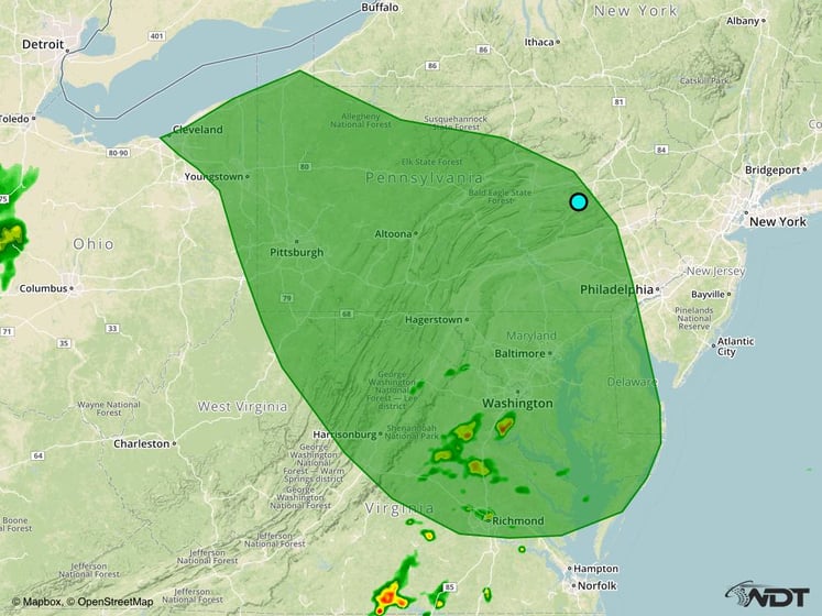
Excessive Rainfall Risk Outline for Thursday and Friday
Tropical Update
Tropical Storm Matthew (green oval) is moving toward the west at 21 mph; this general motion is expected over the next couple of days with a decrease in forward speed. On the current forecast track, the center of Matthew will move through the Windward Islands today and over the eastern Caribbean through Friday. Maximum sustained winds are near 60 mph with higher gusts. Gradual strengthening is forecast during the next couple of days and Matthew could become a hurricane by Friday.
An area of disorganized showers and thunderstorms (red oval) along the coast of the western Gulf of Mexico are associated with a weak area of low pressure near Tampico, Mexico. This low is forecast to move inland today or tonight with no significant development expected.
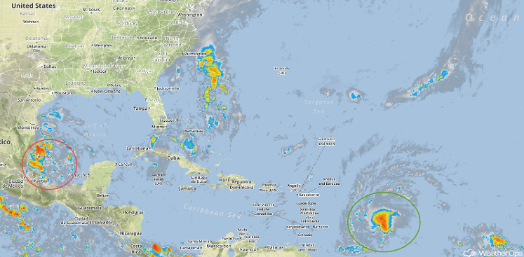
Tropical Infrared Satellite
A Look Ahead
Light rain will be possible across portions of the Great Lakes, Northeast, and Mid Atlantic over the weekend as an area of low pressure over the Ohio Valley lifts northward. Early next week, an area of low pressure will develop in the lee of the Rockies, bringing rain to portions of the Northern Plains and possibly some light snow to portions of the Rockies.
This is just a brief look at current weather hazards. We can provide you site-specific forecast information for the purpose of protecting your personnel and assets. Try a 7-day demo right away and learn how timely precision weather information can enhance your bottom line.


