National Weather Summary for Wednesday, October 25, 2017
by David Moran, on Oct 25, 2017 10:40:58 AM
Heavy to excessive rainfall is expected across portions of New England on Wednesday along a stalled front.
- Excessive Rainfall for Portions of New England Wednesday and Thursday
- Potential for Snow Thursday across the Northern Plains
- Thunderstorms Friday for the Mississippi River Valley
- Tropical Update
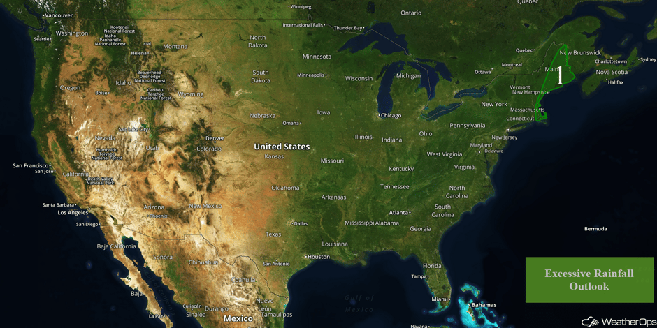 US Hazards
Excessive Rainfall for Portions of New England Wednesday and Thursday
A stalled front and a developing area of low pressure will lead to a threat for heavy to excessive rainfall Wednesday into Thursday. Southerly winds will continue to bring warm moist air northward today and tomorrow. With this stalled frontal boundary providing ample lift today, ongoing rain and thunderstorm activity will move little this morning and afternoon. In addition to this stalled frontal boundary, an area of low pressure will develop off the Delmarva coast and track northward along this boundary further enhancing rain and thunderstorm activity tonight into tomorrow. Rainfall amounts of 2-4 inches with locally higher amounts in excess of 6 inches are forecast over the next two days. This will lead to an enhanced risk of flash flooding and runoff.
Major Cities in Region: Boston, MA, Portland, ME, Augusta, ME, Bangor, ME, Caribou, ME
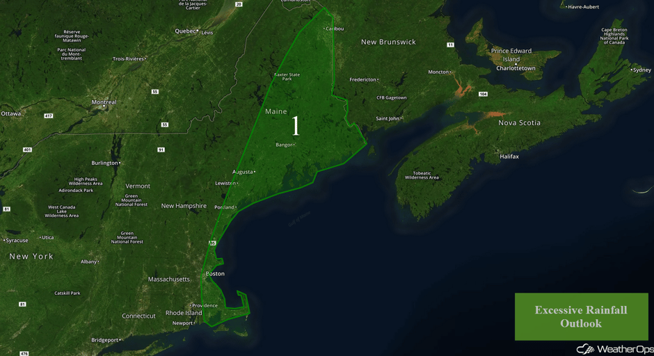 Region 1
Potential for Snow Thursday across the Northern Plains
A strong area of low pressure will move through eastern North Dakota and northern Minnesota Thursday and Friday. This will bring very strong winds of 25-35 mph with gusts in excess of 50 mph are forecast. Snow is also expected, which should begin midday Thursday and continue into Friday. Snow accumulations of 3-5 inches with locally higher amounts in excess of 6 inches are expected in addition to blizzard conditions. Visibilities could be reduced to less than 1/4 mile at times, making travel very hazardous.
Major Cities in Region: Grand Forks, ND, Fargo, ND
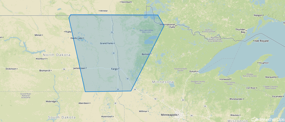 WDT Hazardous Winter Weather Watch for Thursday
Thunderstorms Friday for the Mississippi River Valley
A cold front will be tracking across the Mississippi River Valley on Friday. Ahead of this cold front, southerly flow from the Gulf of Mexico will bring ample low level moisture northward. With building instability and increasing wind shear, scattered showers and thunderstorms are forecast to increase in coverage and intensity during the afternoon hours. Hail and damaging winds will be the primary hazards with any of the stronger storms.
Major Cities in Region: Houston, TX, Memphis, TN, Jackson, MS, New Orleans, LA, Birmingham, AL, Nashville, TN, Cincinnati, OH, Knoxville, TN
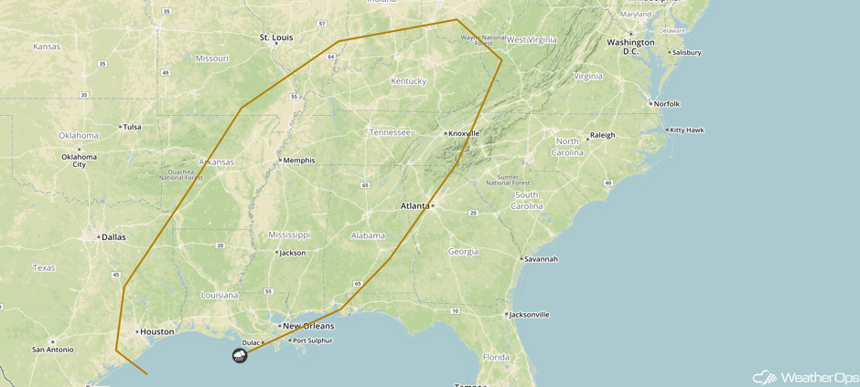 SPC Convective Outlook for Friday
Tropical Update
A broad area of low pressure located over the western Caribbean Sea continues to produce disorganized showers and thunderstorms over Nicaragua, Honduras, and the adjacent waters. Close proximity to land is likely to limit development of this system for the next day or so. However, environmental conditions are expected to be conducive for the system to become more organized later this week as it moves slowly northward over the northwestern Caribbean Sea. Strong upper level winds associated with an approaching cold front will likely prevent further development by Sunday. Regardless, locally heavy rains are likely over portions of Central America and Cuba over the next several days.
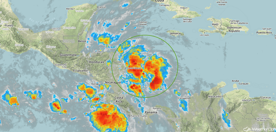 Enhanced Infrared Tropical Satellite
A Look Ahead
There will be a threat for heavy to excessive rainfall across the Northeast on Sunday as a cold front pushes through the region. Ongoing rain and general thunderstorm activity will track eastward along a frontal boundary with southerly flow out ahead of the front bringing ample moisture northward into the Northeast; this rain and thunderstorm activity will increase in intensity and coverage bringing the threat for heavy to excessive rainfall to the region. Model guidance currently suggests that rainfall amounts with 2-4 inches with locally higher amounts in excess of 5 inches are forecast. This will result in an increased threat for flash flooding and excessive runoff.
This is just a brief look at current weather hazards. We can provide you site-specific weather forecast information for the purpose of protecting your personnel and assets and to assess your weather risk. Try a 7-day demo right away and learn how timely precision weather information can enhance your bottom line.


