


by David Moran, on Nov 28, 2018 10:25:48 AM
Snow will continue across the Northeast on Wednesday as an area of low pressure moves across the region. A wintry mix will persist across the Northern Plains as a warm front continues to move eastward. Heavy snow is expected across portions of California through Thursday as an area of low pressure approaches. This system will also bring a potential for excessive rainfall to Southern California.
- Continued Snow for the Northeast on Wednesday
- Wintry Mix Wednesday for the Northern Plains
- Heavy Snow for Portions of Northern California through Thursday
- Excessive Rainfall Wednesday for Southern California
- Snow from the Northern Plains through the Great Lakes Friday
- Thunderstorms Friday from the Southern Plains through the Lower Mississippi Valley
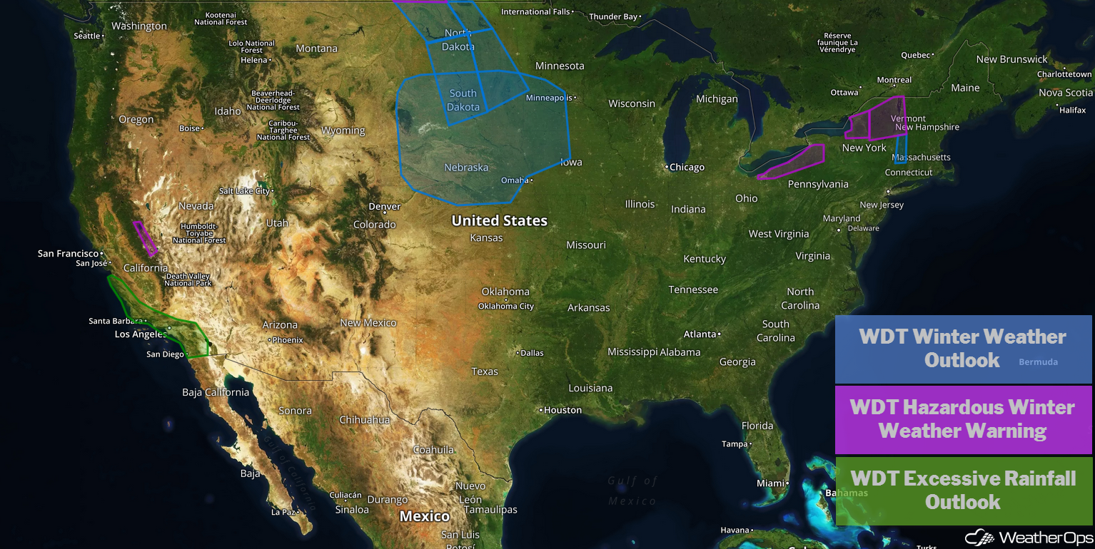
US Hazards
Continued Snow for the Northeast on Wednesday
Snow will continue across the region today before moving out early tomorrow morning. Accumulations of 3-6 inches with locally higher amounts in excess of 8 inches are expected, primarily along the eastern shores of the Great Lakes. Strong winds will create snow drifts and reduced visibilities.
Major Cities in Region: Buffalo, NY, Rochester, NY, Syracuse, NY, Albany, NY, Burlington, VT
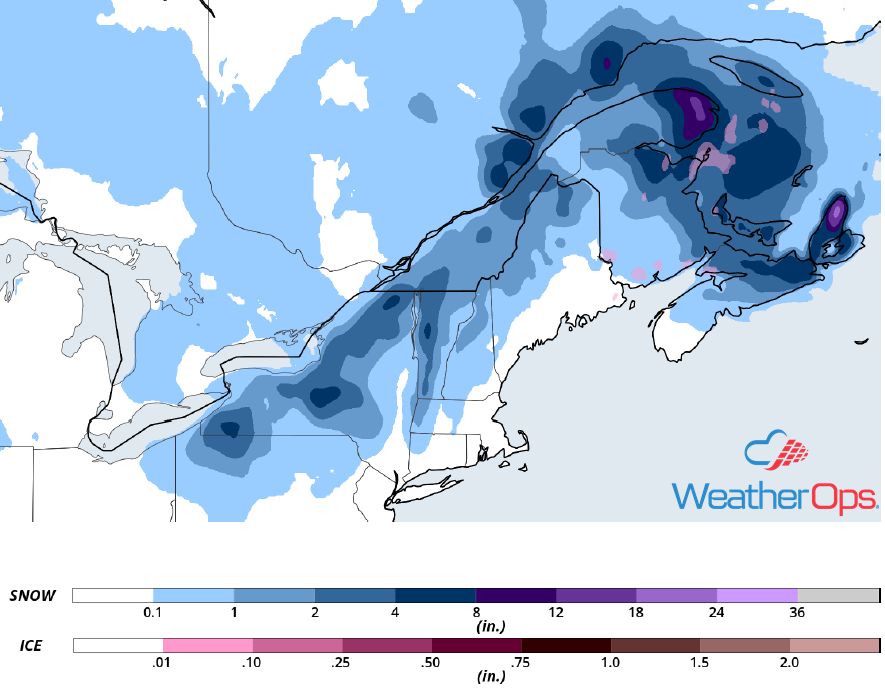
Snowfall Accumulation for Wednesday
Wintry Mix Wednesday for the Northern Plains
A broad region of snowfall and some mixed wintry precipitation will persist across the Northern Plains today. Additional snowfall accumulations of 2-4 inches with locally heavier amounts in excess of 6 inches are expected. In addition, freezing rain may develop; accumulations up to 0.10 inch are forecast.
Major Cities in Region: Grand Forks, ND, Fargo, ND, Sioux Falls, SD
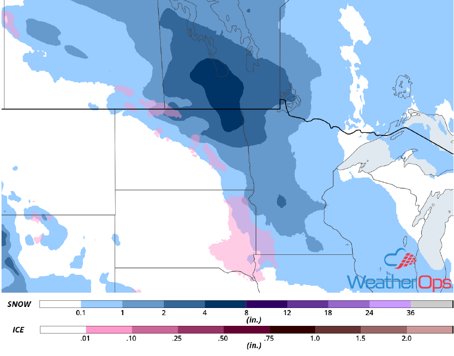
Snow and Ice Accumulation for Wednesday
Heavy Snow for Portions of Northern California through Thursday
An area of low pressure moving inland across California will produce snowfall across the Sierra Nevadas. Lower elevations will pick up 4-8 inches with locally higher amounts in excess of 10 inches. Across the higher elevations, 1-3 feet of snow are forecast. In addition, winds gusting in excess of 40 mph in the lower elevations and 60 mph in the higher elevations will limit visibilities to less than a mile at times.
Major Cities in Region: South Lake Tahoe, CA
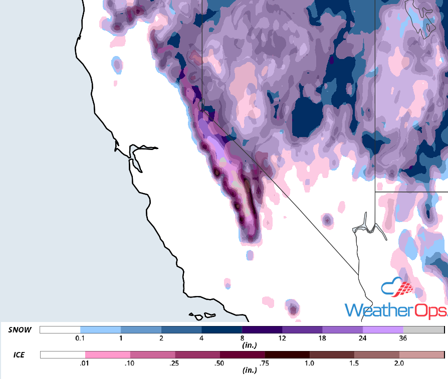
Snowfall Accumulation through Thursday
Excessive Rainfall Wednesday for Southern California
The area of low pressure described above will also produce widespread rainfall across southern California. Rainfall totals will range 1-2 inches with locally higher amounts in excess of 3 inches. In areas recently affected by fires, there will be the potential for mud flows.
Major Cities in Region: Los Angeles, CA, Bakersfield, CA, San Diego, CA
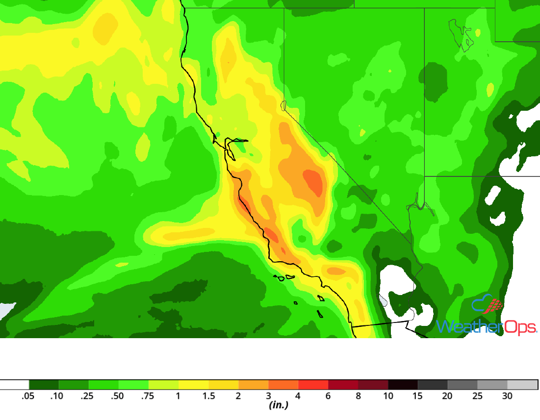
Rainfall Accumulation for Wednesday
Snow from the Northern Plains through the Great Lakes Friday
Another round of snow is expected to begin on Friday and continue through the weekend as an area of low pressure moves eastward. Snowfall accumulations could exceed a foot in some areas. In addition, freezing rain accumulations up to 0.10 inch are forecast. Strong winds could cause limited visibilities and snow drifts.
Major Cities in Region: Rapid City, SD, Pierre, SD, Grand Forks, ND, Sioux Falls, SD, Minneapolis, MN, Green Bay, WI
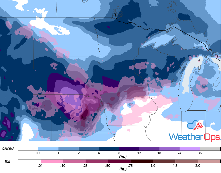
Snowfall Accumulation for Friday
Thunderstorms Friday from the Southern Plains through the Lower Mississippi Valley
As an area of low pressure strengthens across the Southern Plains and moves eastward on Friday, there will be a risk for severe weather. Showers and thunderstorms may develop early in the day, which may limit severe potential. Nevertheless, strong to severe thunderstorms are expected with damaging winds and isolated tornadoes being the primary hazards. Storms should develop across the Southern Plains and move eastward through the evening and overnight hours.
Major Cities in Region: Dallas, TX, Tulsa, OK, Fort Smith, AR. Joplin, MO, Shreveport, LA, Springfield, MO, Little Rock, AR, Memphis, TN, Jackson, MS, New Orleans, LA, Mobile, AL, Pensacola, FL
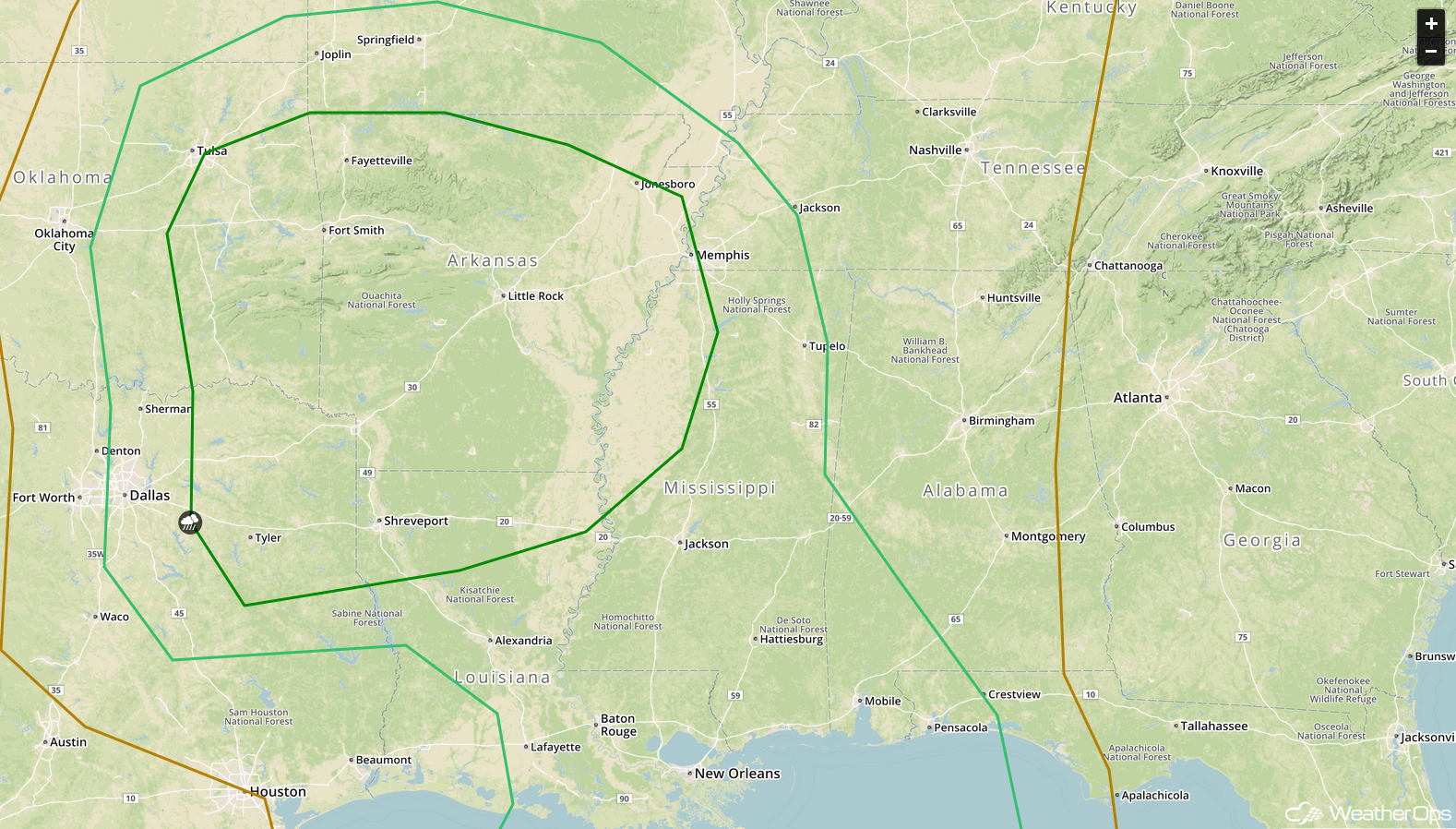
SPC Convective Outlook for Friday
A Look Ahead
Showers and thunderstorms will move into the Ohio Valley on Saturday as the area of low pressure described above continues to move eastward. To the northwest of the low, snow is expected across portions of the Plains. Light snow may develop across the Rockies and High Plains on Sunday as an area of low pressure moves across the Rockies. This snow will move into the Central Plains on Monday. By Tuesday, snow and freezing rain may move into the Great Lakes and Northeast.
