


by David Moran, on Jun 27, 2018 11:37:58 AM
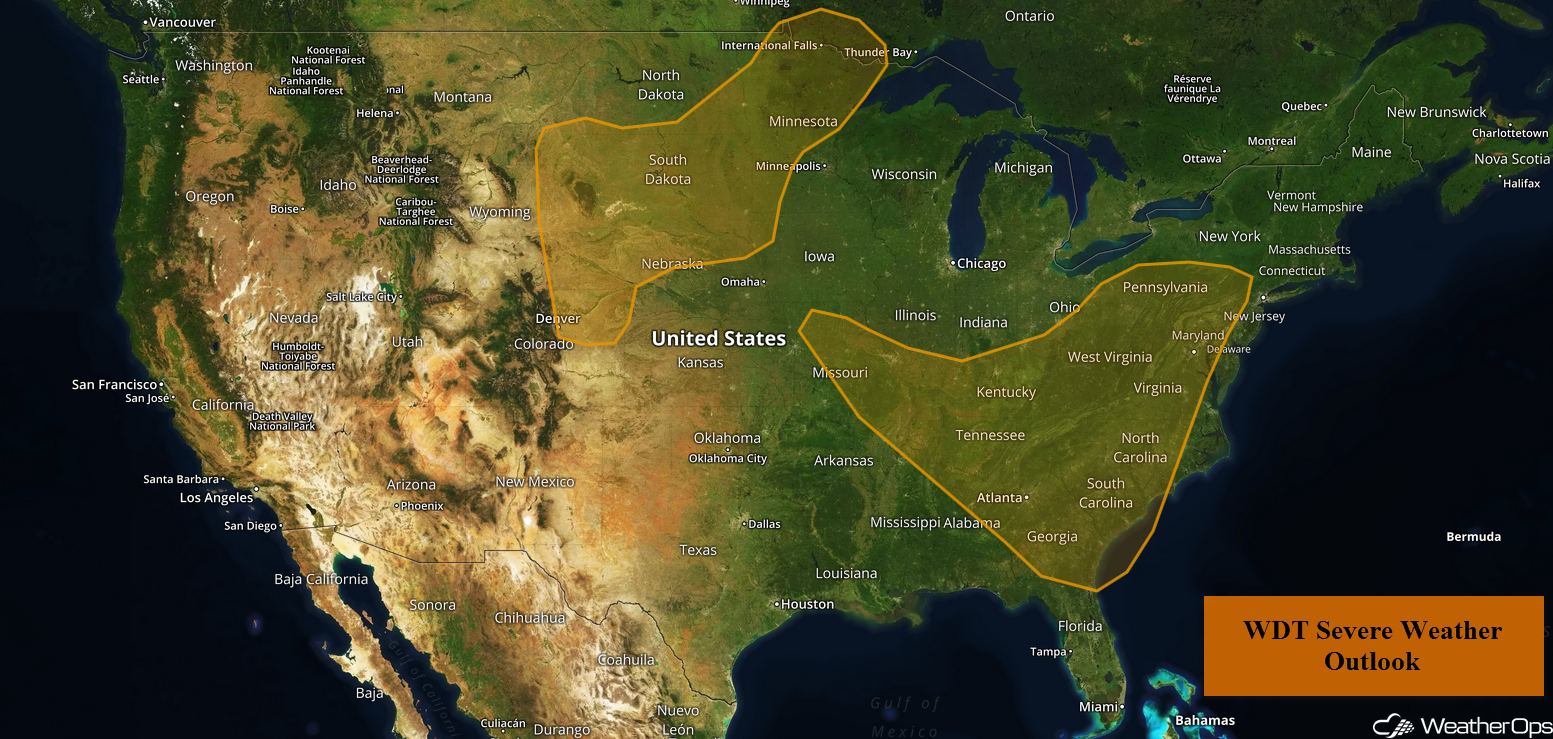
A cold front will be the focus for the development of thunderstorms from the Ozarks into the Appalachians on Wednesday. There will be a risk for excessive rainfall from Central Pennsylvania into Southwest Virginia as thunderstorms develop during the afternoon. An upper level disturbance will allow for the development of thunderstorms across the Western High Plains.
- Thunderstorms from the Ozarks into the Appalachians on Wednesday
- Excessive Rainfall Wednesday from Central Pennsylvania into Southwest Virginia
- Risk for Thunderstorms across the Western High Plains on Wednesday
- Thunderstorm Potential Thursday for the Mid Mississippi Valley
- Thunderstorms across the Northern Rockies and Northern Plains on Thursday
- Risk for Excessive Rainfall Thursday across North Dakota and Northern Minnesota
- Potential for Thunderstorms from the Northern Plains into the Western Great Lakes on Friday
- Tropical Update
 US Hazards

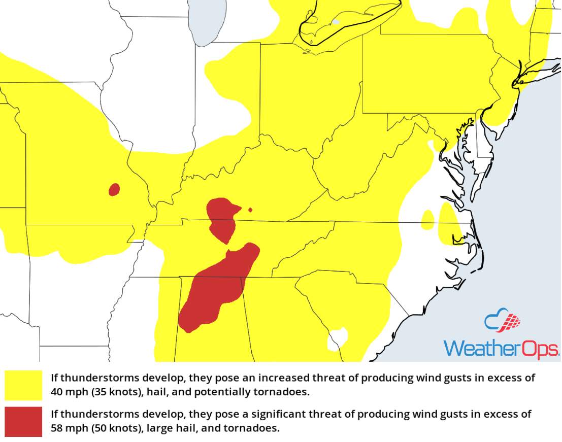
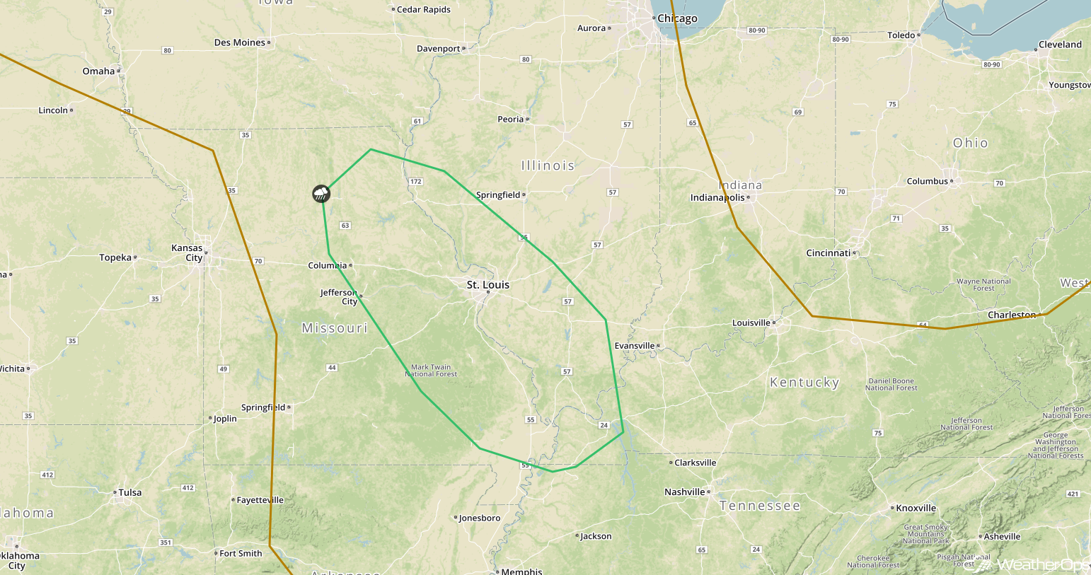
Thunderstorms from the Ozarks into the Appalachians on Wednesday
Light to moderate shower activity will likely limit more substantial thunderstorm development during the first half of the day over the Ohio Valley and surrounding region. However, breaks in the cloud cover should allow instability to build ahead of a cold front during the afternoon. This instability, combined with moderate wind shear, will allow for the development of thunderstorms capable of producing damaging winds. An isolated tornado or two cannot be ruled out.
Major Cities in Region: Columbia, MO, St. Louis, MO, Nashville, TN, Louisville, KY, Cincinnati, OH, Charleston, WV, Harrisonburg, VA
 Thunderstorm Risk for Wednesday
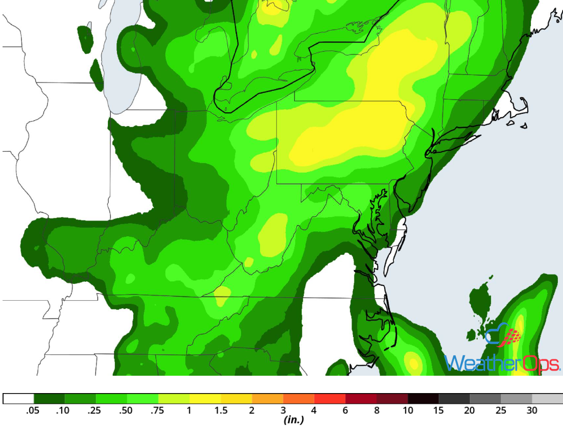
Excessive Rainfall Wednesday from Central Pennsylvania into Southwest Virginia
Showers are currently ongoing across the region. With this shower activity and cloud cover in place, instability may be limited and thus the potential for heavy rainfall will be reduced. However, models indicate that there may be enough instability for the redevelopment of thunderstorms during the afternoon. The strongest storms may produce additional rainfall accumulations of 1-2 inches, leading to a risk for excessive rainfall and localized flash flooding.
Major Cities in Region: Blacksburg, VA, Charleston, WV, Altoona, PA, Williamsport, PA
 Rainfall Accumulation for Wednesday
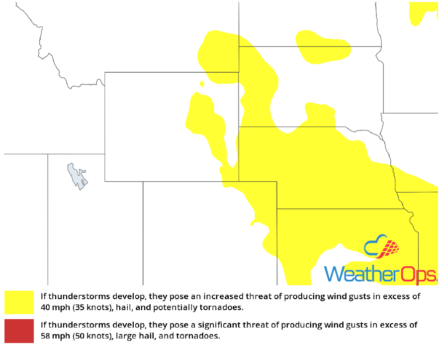
Risk for Thunderstorms across the Western High Plains on Wednesday
An approaching upper level disturbance, combined with abundant moisture and upslope winds during the afternoon, will create an environment favorable for the development of thunderstorms in the lee of the Rockies. Thunderstorms will develop in the higher terrain during the late afternoon and early evening before moving eastward across the High Plains overnight. Damaging winds and large hail will be the primary hazards with these storms.
Major Cities in Region: Cheyenne, WY, Rapid City, SD
 Thunderstorm Risk for Wednesday
Thunderstorm Potential Thursday for the Mid Mississippi Valley
While there is some uncertainty in the forecast, isolated thunderstorms may develop across the region on Thursday along a stalled front. If thunderstorms are able to develop, damaging winds and large hail will be the primary hazards.
Major Cities in Region: Columbia, MO, St. Louis, MO, Paducah, KY
 SPC Convective Outlook for Thursday
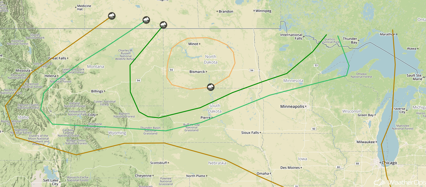
Thunderstorms across the Northern Rockies and Northern Plains on Thursday
An upper level trough will aid in the development of a strong surface low over eastern Montana and Wyoming Thursday afternoon. The low will move into the Dakotas and northern Minnesota Thursday evening. Ahead of the low and associated cold front, high instability and strong shear will allow for the development of severe thunderstorms. Damaging winds will be the primary hazard with these storms as they congeal into a squall line.
Major Cities in Region: Billings, MT, Minot, ND, Bismarck, ND, Pierre, SD, International Falls, MN, Duluth, MN
 SPC Convective Outlook for Thursday
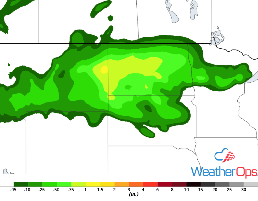
Risk for Excessive Rainfall Thursday across North Dakota and Northern Minnesota
In addition to the severe weather potential described above, there will be a risk for excessive rainfall across portions of North Dakota and northern Minnesota. High moisture content will allow for the potential of very heavy rainfall. Hourly rainfall rates of 2.00-2.50 inches per hour are forecast, resulting in a potential for localized flash flooding.
Major Cities in Region: Minot, ND, Bismarck, ND, Grand Forks, ND, Fargo, ND
 Rainfall Accumulation for Thursday
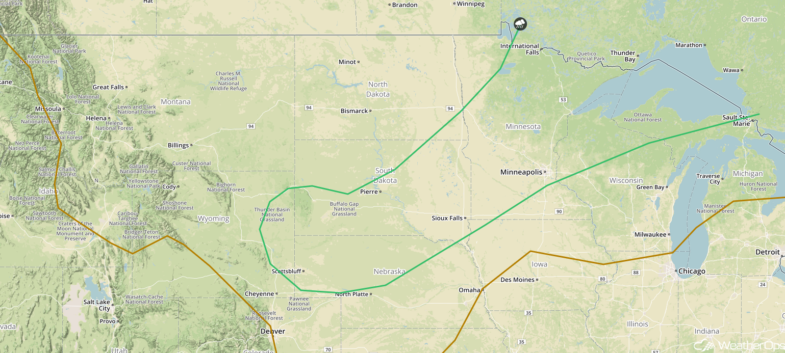
Potential for Thunderstorms from the Northern Plains into the Western Great Lakes on Friday
The complex of thunderstorms described above may continue into early Friday morning. Isolated strong thunderstorms may also develop from Minnesota eastward. The primary hazard with these storms will be damaging winds. A second, stronger, and more widespread round of storms may develop ahead of a cold front during the afternoon. Damaging winds and large hail will be the primary hazards with these storms.
Major Cities in Region: Scottsbluff, NE, Rapid City, SD, Pierre, SD, Sioux Falls, SD, International Falls, MN, Minneapolis, MN, Duluth, MN
 SPC Convective Outlook for Friday
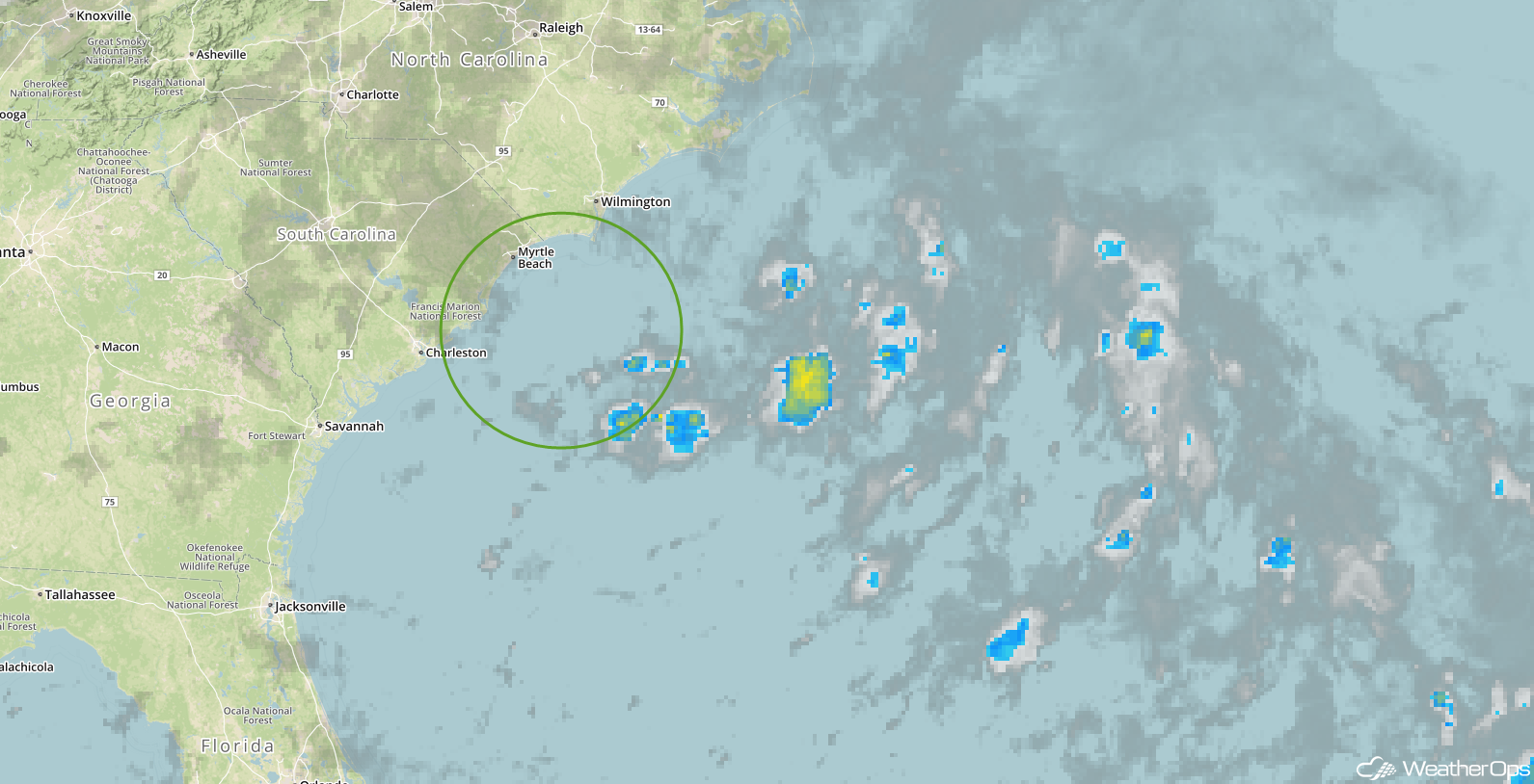
Tropical Update
A weak, non-tropical area of low pressure off the southeastern coast of North Carolina continues to produce a disorganized area of cloudiness and showers. Environmental conditions are not expected to be conducive for development as the system moves northeastward away from the United States during the next couple of days.
 Enhanced Infrared Satellite
A Look Ahead
Showers and thunderstorms may develop across portions of the Great Lakes and Upper Midwest on Saturday ahead of a cold front. By Sunday, light to moderate rain is expected from the Great Lakes into portions of the Southeast. An area of low pressure may develop across the High Plains on Monday, bringing a potential for showers and thunderstorms to the Central Plains. Another area of low pressure will move across the Northern Plains and Upper Midwest on Tuesday, allowing the development of showers and thunderstorms.
This is just a brief look at current weather hazards. We can provide you site-specific weather forecast information for the purpose of protecting your personnel and assets and to assess your weather risk. Try a 7-day demo right away and learn how timely precision weather information can enhance your bottom line.
