National Weather Summary for Wednesday, June 14, 2017
by David Moran, on Jun 14, 2017 11:00:01 AM
Severe thunderstorms are expected across the Midwest and Missouri Valley on Wednesday as an upper level disturbance and cold front move across the region. A few thunderstorms may develop during the afternoon across Virginia and North Carolina. Daytime heating across the Southern Plains may allow for the development of thunderstorms Wednesday.
- Severe Thunderstorms Expected for the Midwest and Missouri Valley on Wednesday
- Thunderstorm Potential Wednesday across Virginia and North Carolina
- Strong to Severe Thunderstorms Possible for the Southern Plains on Wednesday
- Risk for Thunderstorms Thursday across the Ohio Valley and Mid Mississippi Valley
- Thunderstorms for the Central and Southern Plains on Thursday
- Severe Thunderstorms Expected Friday for the Central Plains and Upper Midwest
- Potential for Thunderstorms Across the Southeast on Friday
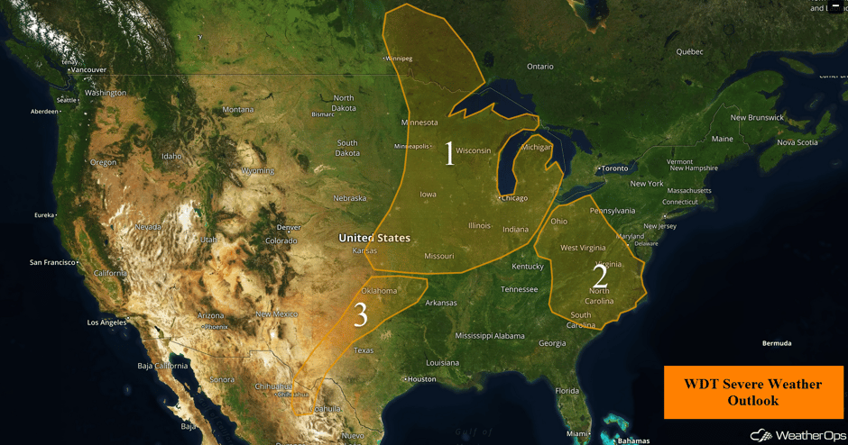 US Hazards
Severe Thunderstorms Expected for the Midwest and Missouri Valley on Wednesday
A slow moving upper level low and its surface low will allow for isolated to widely scattered strong to severe thunderstorms across the region today. As a cold front moves in from the west this afternoon, storms are expected to develop along and ahead of the front. Although morning thunderstorms will affect the environment, daytime heating should destabilize the atmosphere enough that some storms will become severe. Hail and damaging winds will be the primary hazards with these storms. This activity should continue into the evening and overnight hours as they evolve into clusters and move eastward. The primary hazards with these clusters will be damaging winds.
Update 12:19pm CDT: Severe thunderstorm capable of hail and damaging winds SE of Rockford, IL.
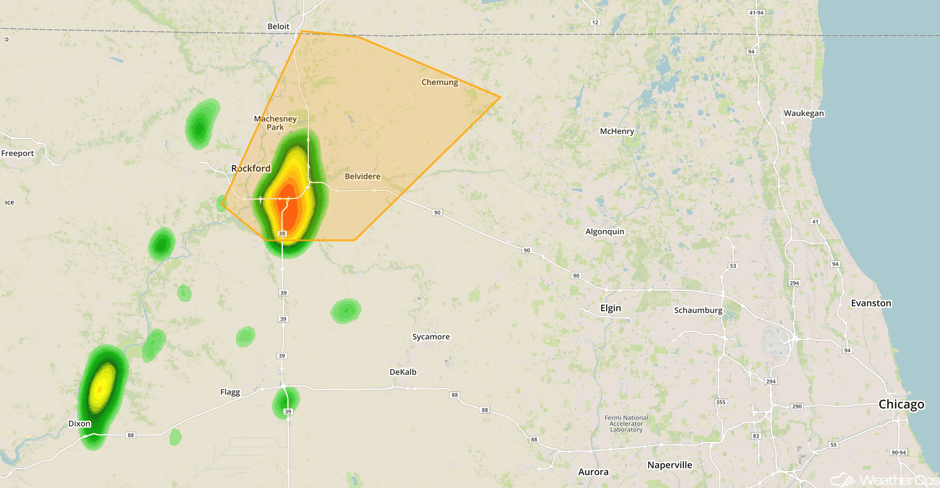 Radar 12:19pm CDT
Update 12:28pm CDT: Severe thunderstorm capable of hail and damaging winds north of St. Louis, MO.
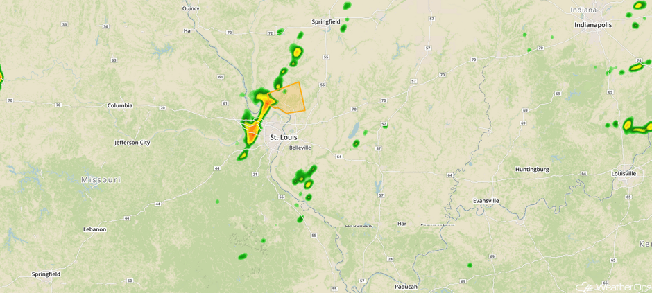 Radar 12:30pm CDT
Update 12:54pm CDT: Severe Thunderstorm Watch in effect for portions of Iowa, Illinois, Indiana, Missouri, and Wisconsin until 8pm CDT.
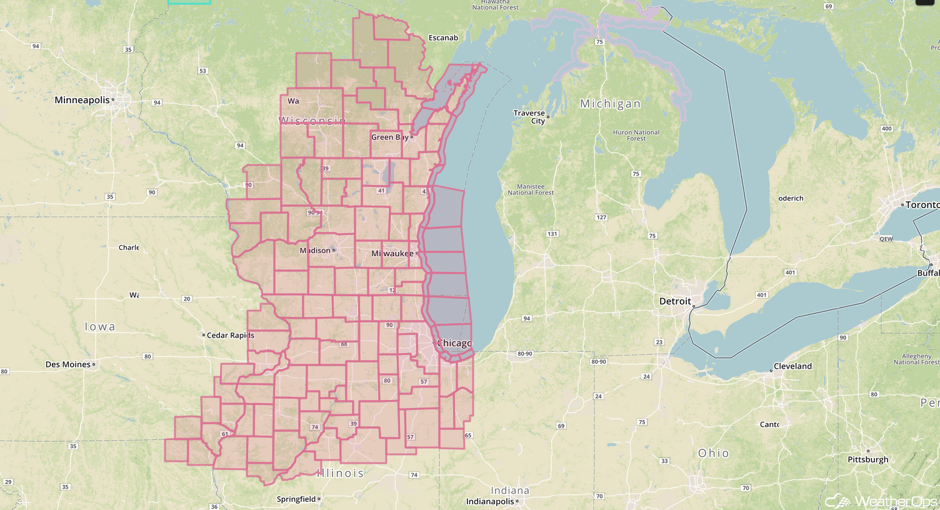 Severe Thunderstorm Watch
Update 1:02pm CDT: Severe thunderstorms capable of hail and damaging winds south of Madison, WI.
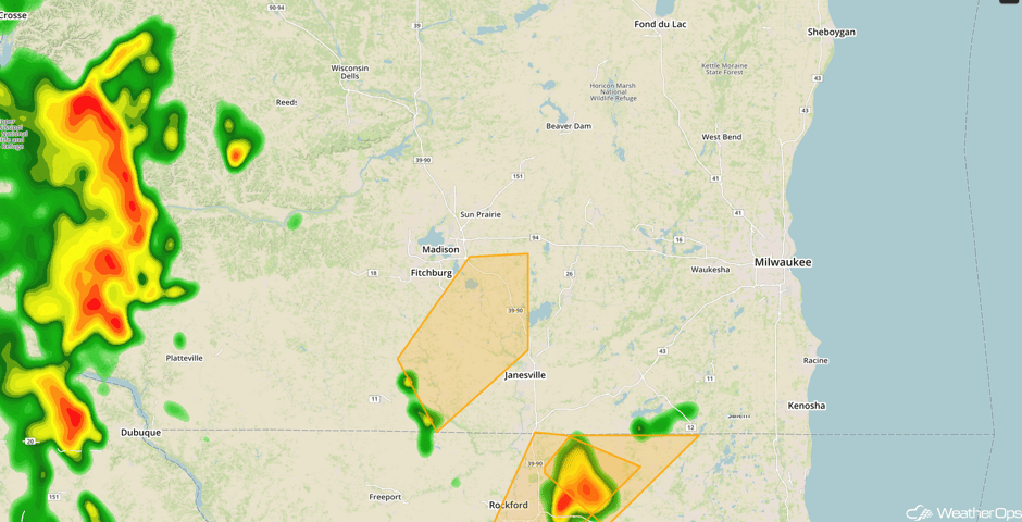 Radar 1:02pm CDT
Update 1:14pm CDT: Severe Thunderstorm Watch for portions of Illinois and Missouri until 8pm CDT.
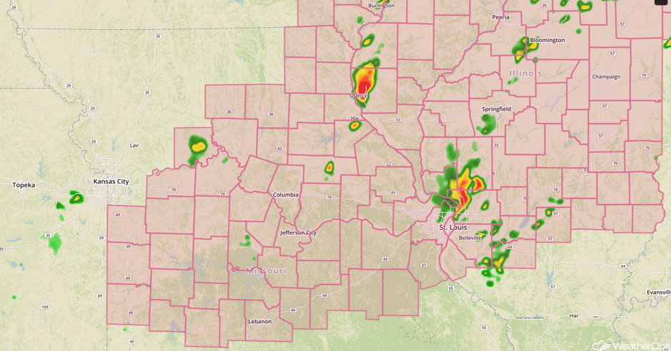 Severe Thunderstorm Watch
Update 1:21pm CDT: Severe thunderstorms capable of damaging winds in SW Wisconsin.
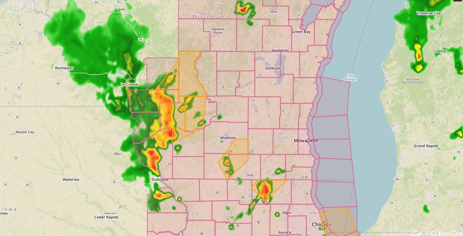 Radar 1:21pm CDT
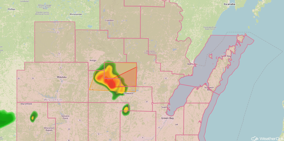
Update 1:49pm CDT: Tornado warned storm NW of Green Bay, WI.
Major Cities in Region: Wichita, KS, Topeka, KS, Kansas City, MO, Des Moines, IA, Minneapolis, MN, St. Louis, MO, Milwaukee, WI, Chicago, IL, Indianapolis, IN, Detroit, MI
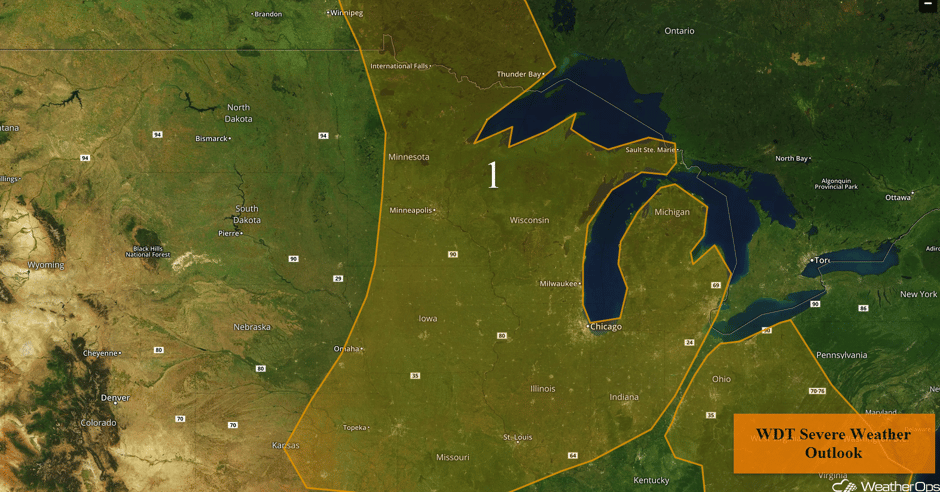 Region 1
Thunderstorm Potential Wednesday across Virginia and North Carolina
Isolated strong to severe thunderstorms are possible across the region on Wednesday. Thunderstorms should develop during the afternoon as instability builds as a result of daytime heating. Damaging winds will be the primary hazards with these storms. Activity should begin to weaken in the evening with the loss of daytime heating. Activity that develops over Missouri, Illinois, and Indiana during the day could move eastward overnight, bringing a slight risk for damaging winds.
Major Cities in Region: Cleveland, OH, Charleston, WV, Pittsburgh, PA, Raleigh, NC, Norfolk, VA
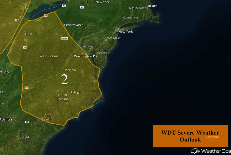 Region 2
Strong to Severe Thunderstorms Possible for the Southern Plains on Wednesday
A dryline and trough extends roughly from southwest Texas north-northeastward into the Oklahoma Panhandle and on into western Kansas. The strongest activity will be in Texas, however, a few thunderstorms may develop across Oklahoma as well. Thunderstorms are expected to develop in the afternoon as daytime heating destabilizes the atmosphere east of the dryline. The primary threats will be large hail and damaging winds. Storms will begin to weaken as daytime heating decreases.
Major Cities in Region: Odessa, TX, Oklahoma City, OK, Tulsa, OK
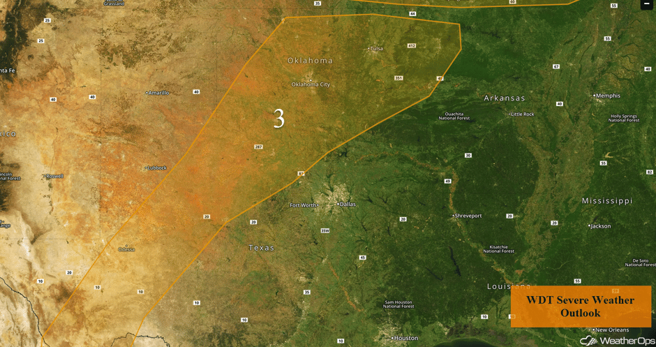 Region 3
Risk for Thunderstorms Thursday across the Ohio Valley and Mid Mississippi Valley
A few thunderstorms may develop across the Ohio and Mid Mississippi Valleys on Friday as moderate instability builds across the region. A few thunderstorms may be severe with strong wind gusts the primary hazard. Activity should diminish by, or just after, dark.
Major Cities in Region: Memphis, TN, Jackson, MS, Atlanta, GA, Charleston, WV, Cleveland, OH, Pittsburgh, PA
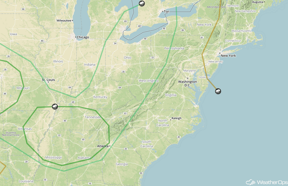 SPC Convective Outlook for Thursday
Thunderstorms for the Central and Southern Plains on Thursday
Thunderstorms may develop from portions of Iowa into Texas. Storm coverage will be limited, but any storms that develop will have the potential for hail and damaging winds.
Major Cities in Region: Lubbock, TX, Oklahoma City, OK, Tulsa, OK, Omaha, NE, Kansas City, MO
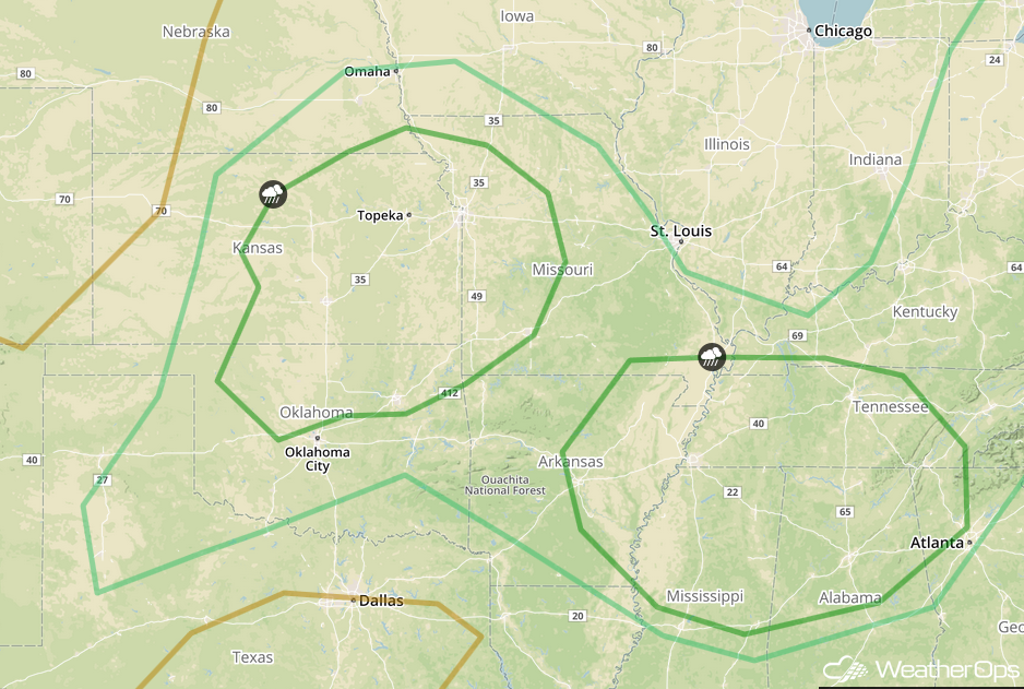 SPC Convective Outlook for Thursday
Severe Thunderstorms Expected Friday for the Central Plains and Upper Midwest
Strong westerly flow aloft will begin to overspread the Central US on Friday. At the surface, an area of low pressure will develop, promoting increasing wind shear. Moisture and instability will remain high, allowing showers and thunderstorms to develop during the day. Large hail, damaging winds, and tornadoes will all be potential hazards with these storms.
Major Cities in Region: Wichita, KS, Topeka, KS, Omaha, NE, Des Moines, IA, St. Louis, MO
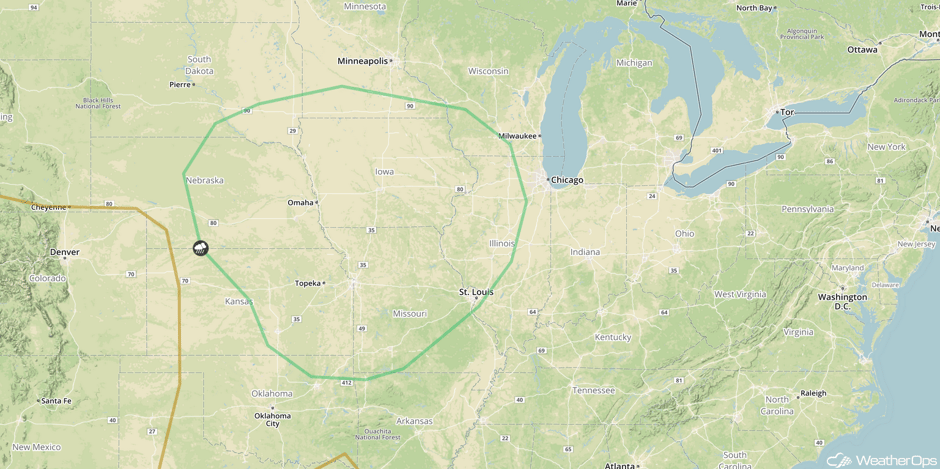 SPC Convective Outlook for Friday
Potential for Thunderstorms Across the Southeast on Friday
A weak area of low pressure will promote the development of showers and thunderstorms from Alabama into the Carolinas on Friday. Severe wind gusts will be the primary hazard with any storms that develop.
Major Cities in Region: Pensacola, FL, Tallahassee, FL, Jacksonville, FL, Atlanta, GA, Raleigh, NC, Washington, DC
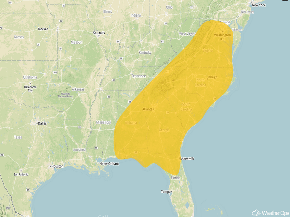 Severe Thunderstorm Risk Outline for Friday
A Look Ahead
A compact, but potent upper level trough is forecast to push through the Upper Midwest region on Saturday, atop a very unstable environment. Northwest flow aloft will likely promote showers and thunderstorms along and ahead of the trough with an increasing threat for widespread damaging wind gusts and isolated hail from the Dakotas and Minnesota, southward, into the Missouri Valley.
This is just a brief look at current weather hazards. We can provide you site-specific weather forecast information for the purpose of protecting your personnel and assets and to assess your weather risk. Try a 7-day demo right away and learn how timely precision weather information can enhance your bottom line.


