National Weather Summary for Wednesday, July 6, 2016
by David Moran, on Jul 6, 2016 11:45:56 AM
An area of low pressure and the associated cold front will bring a risk for strong to severe thunderstorms to portions of the Plains on Wednesday. Instability across the Mississippi Valley and Midwest will allow for the potential for strong to severe thunderstorms during the morning and into the early afternoon. Strong thunderstorms are possible for portions of the Southeast during the afternoon as instability builds. Isolated thunderstorms will be possible across portions west Texas and southwestern Oklahoma during the afternoon and evening hours. As the area of low pressure continues to move across the Plains on Thursday, strong to severe thunderstorms will be possible for the Central Plains and Midwest. By Friday, the area of low pressure will move into the Northeast and thunderstorms will be possible ahead of the associated cold front across the Ohio and Missouri Valleys.
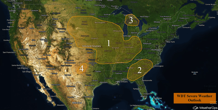
US Hazards
Region 1
Thunderstorms are expected to develop across northwestern portions of Region 1 during the afternoon hours. These storms should quickly merge into a squall line which will track east into portions of South Dakota, Nebraska, Minnesota, and Iowa during the evening and overnight hours. This squall line will be capable of producing damaging wind gusts in excess of 60 mph. A high risk for large hail in excess of once inch in diameter will exist earlier in the event across western portions of Nebraska and South Dakota.
To the east, thunderstorms are ongoing this morning across portions of the Midwest and into the Missouri Valley. While these thunderstorms have been weakening this morning, reintensification will be possible during the afternoon hours, which could result in some wind gusts in excess of 60 mph.
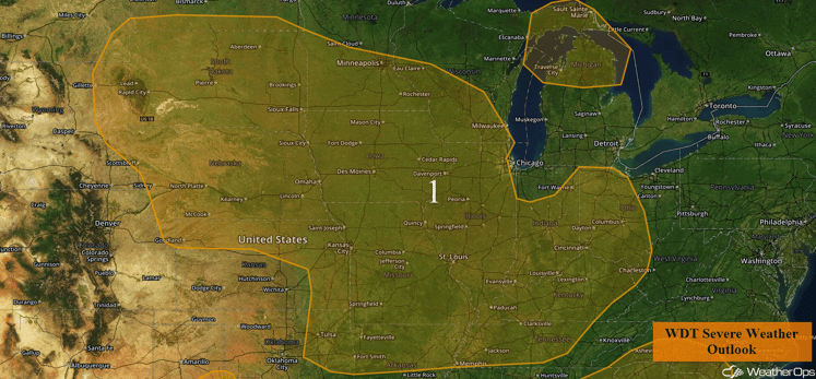
Region 1
Region 2
Thunderstorms are expected to develop during the afternoon hours in response to strong surface heating. A few thunderstorms could become strong and produce wind gusts in excess of 60 mph. The most likely time for severe wind gusts will be during the afternoon and early evening hours, with the severe weather threat diminishing after sunset.
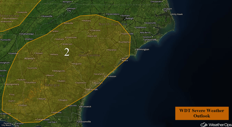
Region 2
Region 3
A few thunderstorms are expected to develop across Region 3 this afternoon. Conditions will be favorable for a few of these thunderstorms to be strong, with wind gusts in excess of 60 mph expected to be the primary hazard. The most likely time for strong to severe thunderstorms will be during the late afternoon to evening hours.
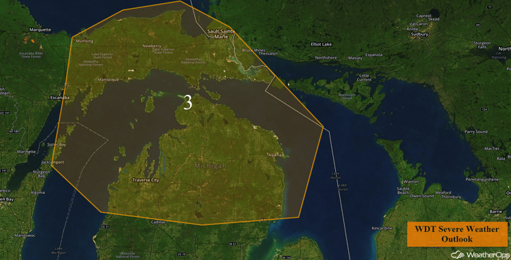
Region 3
Region 4
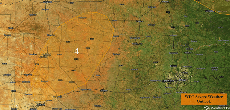
Isolated thunderstorms are expected to develop this afternoon across portions of west Texas and into southwestern Oklahoma. A few thunderstorms could become strong to severe and produce wind gusts in excess of 50 mph. The most likely time for severe weather will be during the afternoon and evening hours, with the severe weather threat diminishing rapidly after sunset.
Region 4
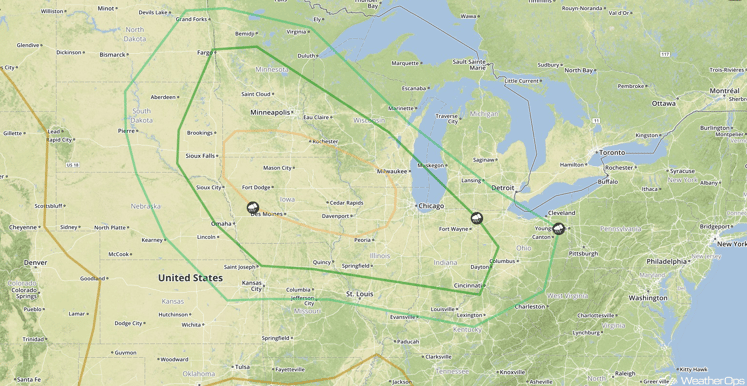
Strong to Severe Thunderstorms Possible Thursday for the Central Plains and Midwest
As an area of low pressure in the Central Plains continues to move eastward toward the Great Lakes region, the associated cold front will stretch southwestward into Iowa and Nebraska. This cold front will continue to progress southeastward and southward as the day progresses, into the Central Plains and Midwest regions. As daytime heating destabilizes the atmosphere, ample moisture coupled with moderate to strong wind shear especially just to the south of the aforementioned front will lead to an increase in intensity and coverage of strong to possibly isolated severe thunderstorms. The main hazards within any thunderstorms that develop will be strong wind gusts, however a few isolated areas of large hail cannot be ruled out.
SPC Convective Outlook for Thursday
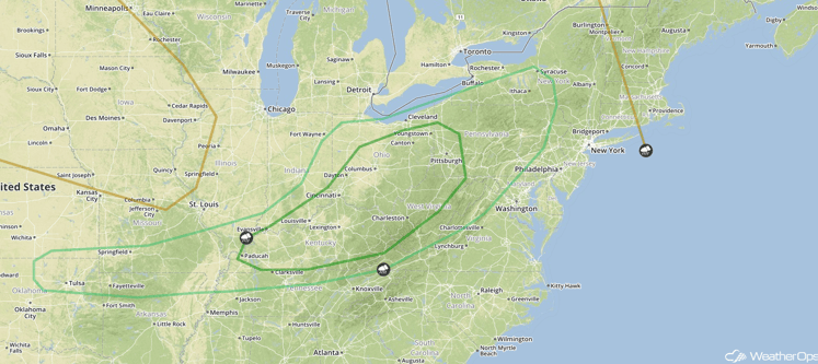
Strong to Severe Thunderstorms Possible for Ohio and Missouri Valleys on Friday
As an area of low pressure moves east northeastward into Southern Canada and the Northeastern US, a cold front will stretch southwestward into the Ohio and Missouri Valleys. With increasing instability across the region as a result of daytime heating as well as ample moisture and wind shear, especially south of the cold front, strong to severe thunderstorms are possible Friday afternoon. Although coverage of strong to severe thunderstorms is expected to remain isolated at this time, there will still be a threat for strong wind gusts as well as some isolated pockets of hail within any thunderstorms that develop.
SPC Convective Outlook for Friday
This is just a brief look at current weather hazards. We can provide you site-specific forecast information. Try a 7-day demo right away.


