National Weather Summary for Wednesday, July 19, 2017
by David Moran, on Jul 19, 2017 10:52:18 AM
Severe thunderstorms are expected Wednesday across the Northern Plains and Upper Midwest along a stalled frontal boundary. Monsoonal rains are forecast to continue for the Intermountain West into the Southwest on Wednesday.
- Severe Thunderstorms Expected for the Northern Plains and Upper Midwest on Wednesday
- Thunderstorm Potential for Southern Arizona on Wednesday
- Thunderstorms Continuing for Northern Gulf of Mexico through Early Wednesday Afternoon
- Continued Excessive Rainfall through Friday for the Intermountain West and Southwest
- Risk for Thunderstorms Thursday across the Northern Plains
- Potential for Thunderstorms from the Midwest to the Northeast on Thursday
- Thunderstorms for the Plains into the Midwest on Friday
- Tropical Update
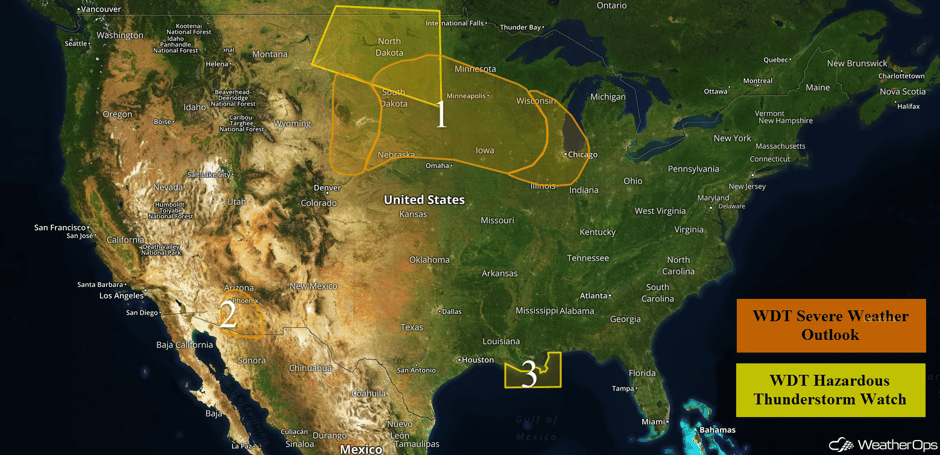 US Hazards
Severe Thunderstorms Expected for the Northern Plains and Upper Midwest on Wednesday
A complex of showers and thunderstorms is currently moving across portions of North Dakota. By late afternoon, marginal instability and strengthening winds aloft should allow for the development of isolated thunderstorms. Large hail and damaging winds will be the primary hazards with any storms that develop. From the Dakotas and Nebraska into the Great Lakes, thunderstorms will develop along a warm front. Any storms that develop in this region will have the potential for large hail, damaging winds, and isolated tornadoes. By late evening, thunderstorms will move into eastern portions of the region with large hail the primary hazard.
Update 11:15am CDT: Severe Thunderstorm Watch for portions of South Dakota until 3pm CDT.
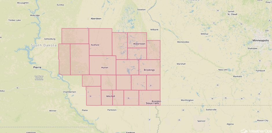 Severe Thunderstorm Watch
Update 12:43pm CDT: Severe Thunderstorm Watch in effect for portions of Iowa and Minnesota until 6pm CDT.
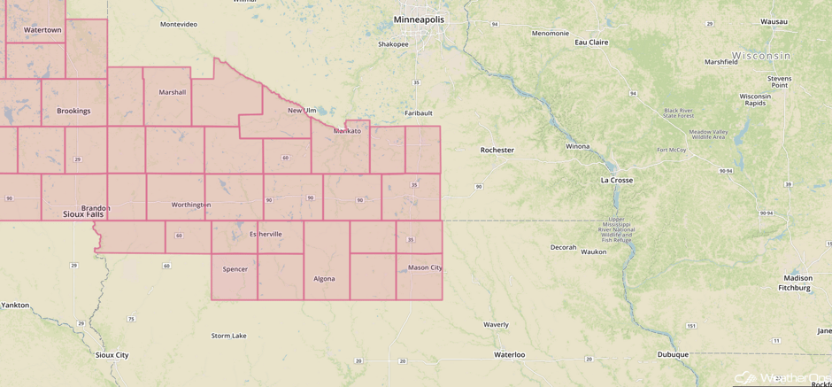 Severe Thunderstorm Watch
Major Cities in Region: North Platte, NE, Minot, ND, Bismarck, ND, Pierre, SD, Sioux Falls, SD, Des Moines, IA, Minneapolis, MN, Green Bay, WI, Milwaukee, WI, Chicago, IL
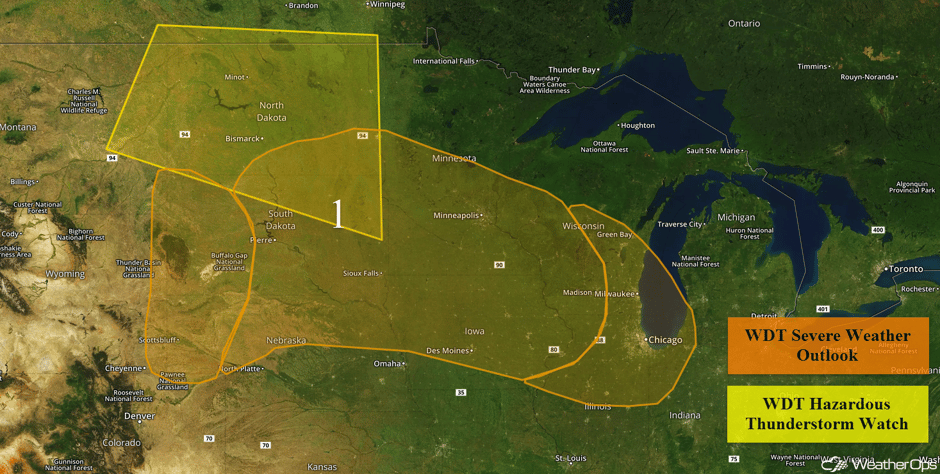 Region 1
Thunderstorm Potential for Southern Arizona on Wednesday
Widely scattered thunderstorms are likely to develop over the higher terrain of southern Arizona early this afternoon. An upper level disturbance combined with adequate moisture at the surface will yield a low threat of damaging winds within some of the more organized storms that form. The primary threat will be between 1pm and 9pm local time.
Major Cities in Region: Phoenix, AZ, Tucson, AZ
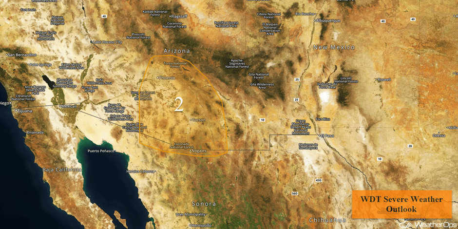 Region 2
Thunderstorms Continuing for Northern Gulf of Mexico through Early Wednesday Afternoon
Thunderstorms will continue for portions of the northern Gulf of Mexico through the early afternoon. Wind gusts in excess of 35 knots, lightning, and locally enhanced seas will all be potential hazards.
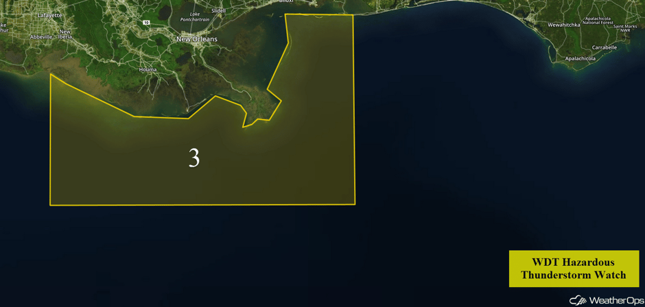 Region 3
Continued Excessive Rainfall through Friday for the Intermountain West and Southwest
Monsoonal rains will slowly spread eastward across portions of the Intermountain West and Southwest through Friday. Rainfall amounts of 1-2 inches with locally higher amounts in excess of 3 inches are forecast. Daily rainfall amounts should be less than 0.75 inch. There may be an increased risk of flooding and runoff as well.
Major Cities in Region: Provo, UT, Phoenix, AZ, Flagstaff, AZ, Tucson, AZ, Grand Junction, CO
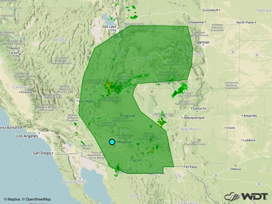 Excessive Rainfall Risk Outline Wednesday through Friday
Risk for Thunderstorms Thursday across the Northern Plains
A weak trough aloft is forecast to move across the region with a warm front lifting northward. Along the front, instability is forecast to develop into the afternoon leading to strong to severe thunderstorms. Strong wind gusts and hail will be the primary hazards, as well as frequent lightning and heavy rainfall.
Major Cities in Region: Cheyenne, WY, North Platte, NE, Bismarck, ND, Pierre, SD, Sioux Falls, SD
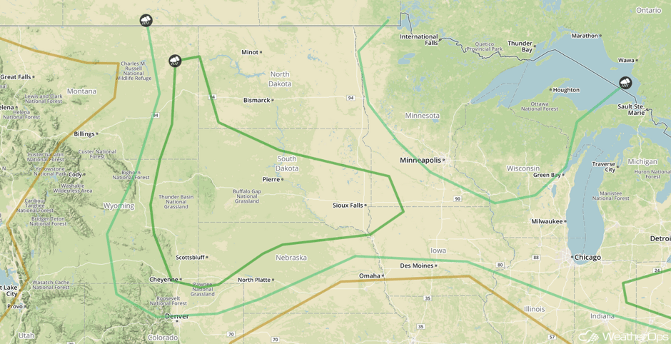 SPC Convective Outlook for Thursday
Potential for Thunderstorms from the Midwest to the Northeast on Thursday
Lingering precipitation from overnight thunderstorms are forecast throughout the region into the morning hours. As a result, there is some uncertainty in the overall coverage of activity into Thursday. However, some strong to severe thunderstorms will be possible. Ahead of an area of low pressure and cold front, daytime heating along with outflow boundaries in the region will lead to some lift for the development of strong to severe thunderstorms into the afternoon and evening. Strong wind gusts and hail along with frequent lightning and heavy rainfall are the main severe weather threats on Thursday. Thunderstorms may continue into the evening and overnight hours.
Major Cities in Region: Columbus, OH, Cleveland, OH, Pittsburgh, PA, Buffalo, NY, Syracuse, NY
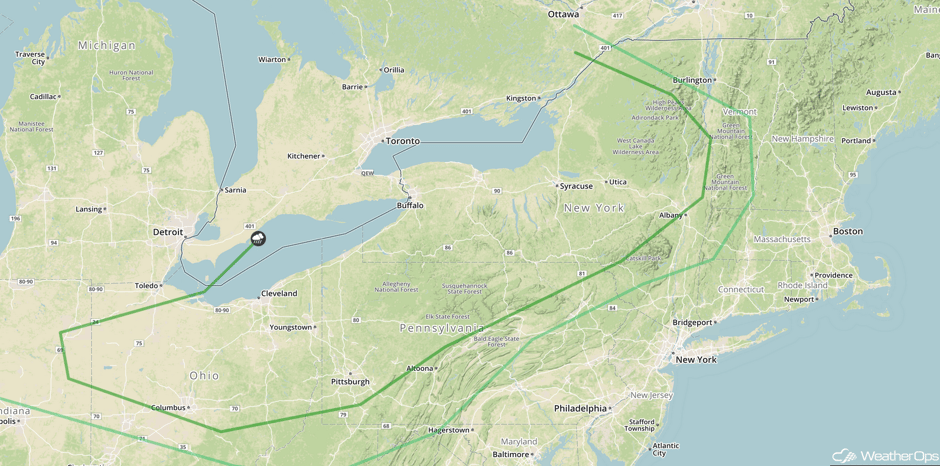 SPC Convective Outlook for Thursday
Thunderstorms for the Plains into the Midwest on Friday
Thunderstorm activity from the overnight hours will linger into the morning with heavy rain the primary hazard. Into the afternoon, daytime heating will allow instability to build ahead of an area of low pressure. With some upper level support, strong to severe thunderstorms capable of strong wind gusts, large hail, frequent lightning, and heavy rainfall may develop.
Major Cities in Region: North Platte, NE, Bismarck, ND, Pierre, SD, Sioux Falls, SD, Omaha, NE, Des Moines, IA, Minneapolis, MN, Milwaukee, WI, Chicago, IL, Detroit, MI, Cleveland, OH, Pittsburgh, PA
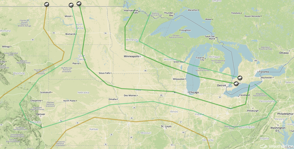 SPC Convective Outlook for Friday
Tropical Update
An area of low pressure between the Cabo Verde Islands and the Lesser Antilles is producing a large area of disorganized showers and thunderstorms. Some development is possible over the next day or two while it moves toward the west-northwest or northwest at 10-15 mph. After that time, environmental conditions are forecast to become unfavorable for development.
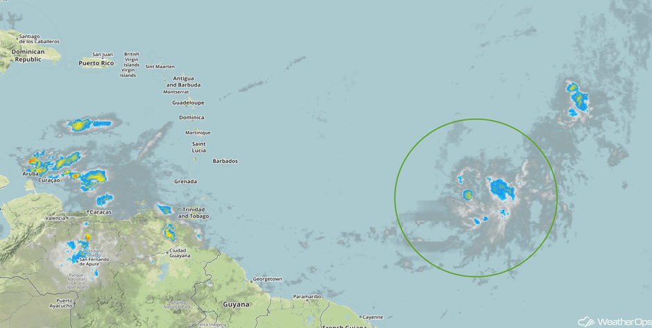 Tropical Enhanced Infrared Satellite
A Look Ahead
Thunderstorms, some severe, are forecast across the Ohio Valley on Saturday as a cold front moves eastward. By Sunday, this activity will spread into the Appalachians.
This is just a brief look at current weather hazards. We can provide you site-specific weather forecast information for the purpose of protecting your personnel and assets and to assess your weather risk. Try a 7-day demo right away and learn how timely precision weather information can enhance your bottom line.


