National Weather Summary for Wednesday, January 3, 2018
by David Moran, on Jan 3, 2018 10:49:26 AM
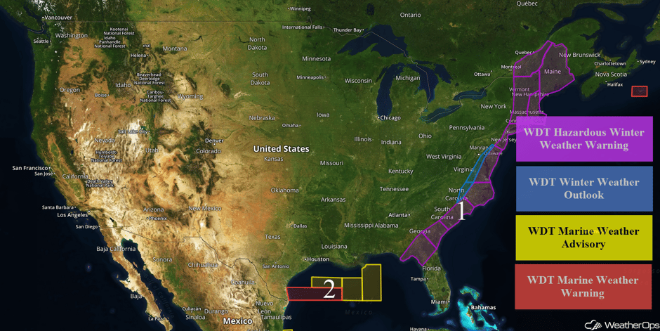
Wintry precipitation will continue along the East Coast through Friday as an area of low pressure moves northward. Elevated winds and seas will continue for portions of the Gulf of Mexico through early Thursday as an upper level trough moves across the region.
- Wintry Precipitation Continuing along the East Coast through Friday
- Elevated Winds and Seas through early Thursday for Portions of the Gulf of Mexico
 US Hazards
Wintry Precipitation Continuing along the East Coast through Friday
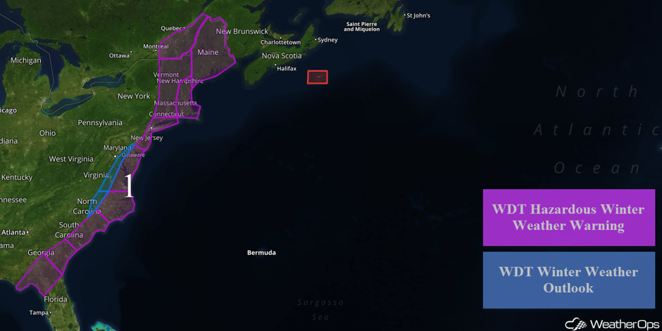
A mixture of sleet and freezing rain is expected to continue through midday Wednesday across portions of northern Florida and southern Georgia as an area of low pressure rapidly intensifies just east of the Florida Peninsula. Prior to ending, some snow may mix in briefly. Ice accumulations of 0.1-0.3 inch are expected and may result in the potential for hazardous travel. From southeastern Georgia into South Carolina, snow accumulations of 1-3 inches and ice accumulations of 0.1-0.2 inch are forecast.
Across central South Carolina into southern North Carolina, 2-4 inches of snow are forecast. For portions of central and northern North Carolina, 4-8 inches of snow, as well as 0.1-0.2 inch of ice are expected. In addition, winds of 15-25 mph inland and 25-45 mph with higher gusts near the coast will limit visibilities to less than half a mile at times. Further inland from central North Carolina into northern Maryland, snow accumulations of 1-3 inches with locally higher amounts in excess of 4 inches are expected, Wind chills will range 15-25°F. From Virginia into the Delmarva Peninsula, 4-7 inches of snow with locally higher accumulations in excess of 10 inches are forecast through mid morning Thursday. In addition, freezing rain accumulations of 0.05 inches are expected. Winds will range 20-30 mph with gusts in excess of 35 mph.
From New Jersey northward into Connecticut, 4-7 inches of snow with locally higher amounts in excess of 10 inches are expected Thursday. Winds of 20-30 mph with gusts in excess of 35 mph are forecast. Across western portions of Connecticut northward into Vermont and New Hampshire, 4-7 inches of snow with locally higher amounts in excess of 10 inches are expected through Friday morning. Accumulations of 7-10 inches with locally higher amounts in excess of 15 inches are forecast for portions of eastern Massachusetts and southern New Hampshire. For much of Maine, 9-14 inches of snow with locally higher amounts in excess of 20 inches are expected through Friday evening.
Major Cities in Region: Tallahassee, FL, Savannah, GA, Charleston, SC, Myrtle Beach, SC, Raleigh, NC, Norfolk, VA, Richmond, VA, Atlantic City, NJ, New York, NY, Boston, MA, Portland, ME, Caribou, ME
 Region 1
Elevated Winds and Seas through early Thursday for Portions of the Gulf of Mexico
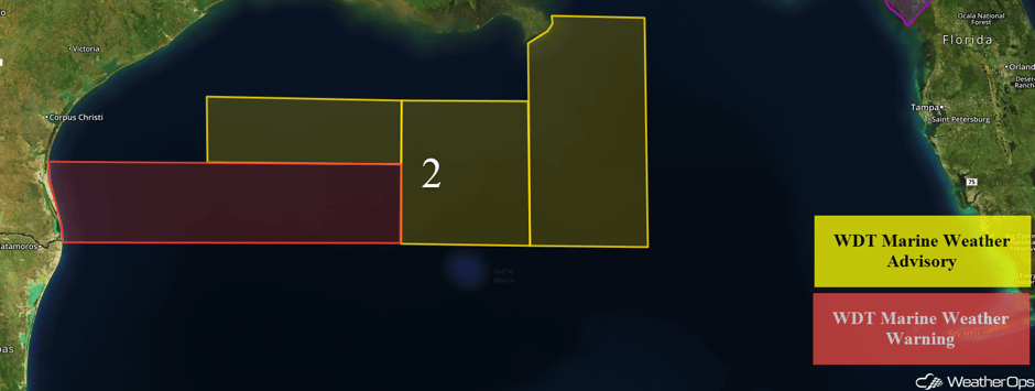
An upper level trough tracking across the Gulf of Mexico will allow for elevated winds and seas through early Thursday. Winds will range 20-25 knots with gusts in excess of 35 knots across western areas with seas building to 8-11 feet. Across eastern areas, winds will range 17-22 knots with gusts in excess of 25 knots. Seas will range 5-7 feet in eastern areas and 6-9 feet across northern areas.
 Region 2
A Look Ahead
Calmer conditions are expected for much of the East Coast on Saturday as high pressure builds into the region. Across the west, snow may develop across the Intermountain West in association with a frontal boundary. Accumulations of 5-10 inches are anticipated for portions of Idaho, Wyoming, Utah, and Colorado. On Sunday, an area of low pressure will develop along a frontal boundary in the Central Plains before tracking into the Ozarks and Upper Midwest. With moisture lifting northward, a few inches of snow may develop across portions of Illinois, Indiana, Ohio, and Southern Michigan. Further south, a few strong thunderstorms may develop across the Deep South.
This is just a brief look at current weather hazards. We can provide you site-specific weather forecast information for the purpose of protecting your personnel and assets and to assess your weather risk. Try a 7-day demo right away and learn how timely precision weather information can enhance your bottom line.


