


by David Moran, on Feb 21, 2018 10:57:01 AM
Wintry precipitation will continue for portions of the Plains into the Midwest as a stationary front begins to lift to the north. Thunderstorms may develop for portions of Louisiana during the afternoon and evening as an upper level trough moves across the region. Snow may develop across portions of the Pacific Northwest as an area of low pressure moves into the region. The front mentioned above will allow for continued excessive rainfall from east Texas into the Lower Mississippi Valley.
- Wintry Precipitation for the Plains and Midwest through Thursday
- Potential for Snow Wednesday across Portions of the Pacific Northwest
- Thunderstorms for the Lower Mississippi Valley Wednesday
- Snow Thursday and Friday for the Northern Plains
- Excessive Rainfall Continuing from the Southern Plains into the Ohio Valley through Saturday
 US Hazards

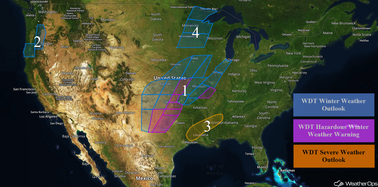
Wintry Precipitation for the Plains and Midwest through Thursday
Southern Plains:
A mix of freezing rain, sleet, and snow will continue across the Southern Plains through Thursday morning. Across west Texas, a mixture of sleet and freezing rain is expected through Wednesday. Up to a tenth of an inch of ice is expected. Sleet accumulations will generally be less than an inch. Winds of 15-20 mph will allow for wind chills between 10 and 20°F. Further east into central Texas, freezing rain and sleet accumulations are forecast to be less than 0.20 inch. For western Oklahoma, freezing rain accumulations up to 0.20 inch and sleet accumulations less than 0.50 inch are expected. Across central Oklahoma, ice accumulations will generally range from a glaze to a quarter inch of ice, but portions of south central Oklahoma may pick up as much as 0.40 inch. Sleet accumulations will generally be less than a quarter of an inch. From eastern Oklahoma into western Arkansas, ice accumulations up to 0.20 inch are expected.
Central Plains/Midwest:
Across western and south central Kansas, snow accumulations will range 1-3 inches, From north central Kansas to western Iowa, snowfall amounts will range 3-5 inches. For portions of eastern Kansas and western Missouri, ice accumulations up to a quarter of an inch and sleet accumulations to half an inch are expected. Across northern Missouri into southern Iowa, snow accumulations will range 1-3 inches with locally higher amounts in excess of 4 inches. In addition, ice accumulations to 0.20 inch and sleet accumulations up to half an inch are expected. Across south central Missouri, ice accumulations will range 0.05-0.15 inches. Further east across southeast Missouri, ice accumulations between 0.20-0.50 inch are forecast. From east central Missouri to northeastern Illinois, including Chicago, up to 0.20 inch of ice is expected.
Major Cities in Region: Lubbock, TX, Amarillo, TX, Oklahoma City, OK, Wichita, KS, Tulsa, OK, Omaha, NE, Kansas City, MO, Des Moines, IA, St. Louis, MO, Chicago, IL
 Region 1
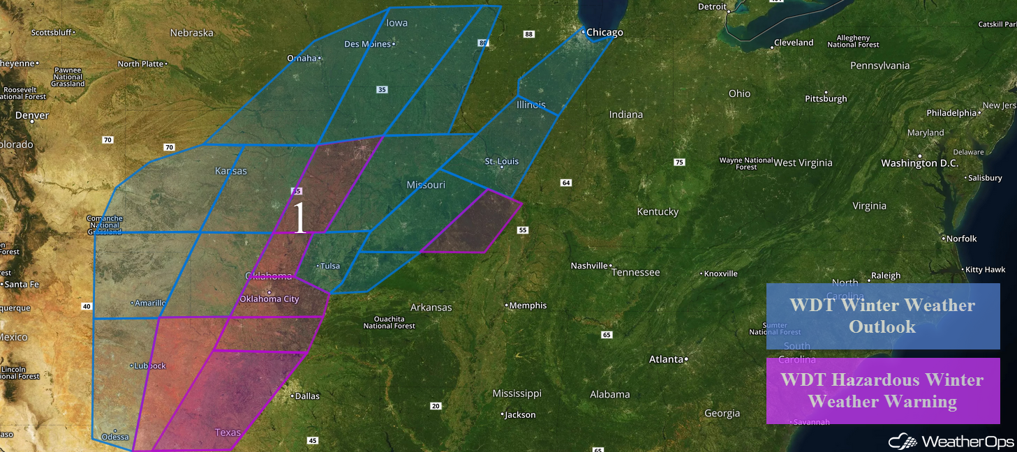
Potential for Snow Wednesday across Portions of the Pacific Northwest
Snow will continue for portions of Oregon and Washington through the morning as an area of low pressure moves inland. Accumulations of 2-4 inches are expected.
Major Cities in Region: Medford, OR, Bend, OR
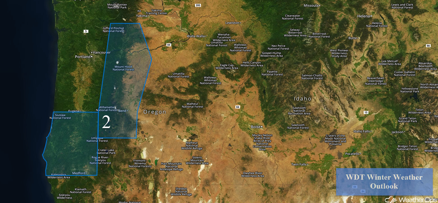
Thunderstorms for the Lower Mississippi Valley Wednesday
Ongoing thunderstorms across East Texas will spread eastward throughout the day ahead of a cold front. Strong winds and perhaps an isolated tornado will be the primary hazards during the morning and afternoon. Thunderstorm activity will decrease during the evening hours.
Major Cities in Region: Beaumont, TX, Alexandria, LA, Jackson, MS
 Region 3
Snow Thursday and Friday for the Northern Plains
Snow is forecast for portions of Minnesota and Wisconsin Thursday night into Friday morning as an upper level disturbance moves through the region. Snowfall totals of 2-4 inches with locally higher amounts in excess of 5 inches are forecast.
Major Cities in Region: International Falls, MN, Minneapolis, MN, Rochester, MN
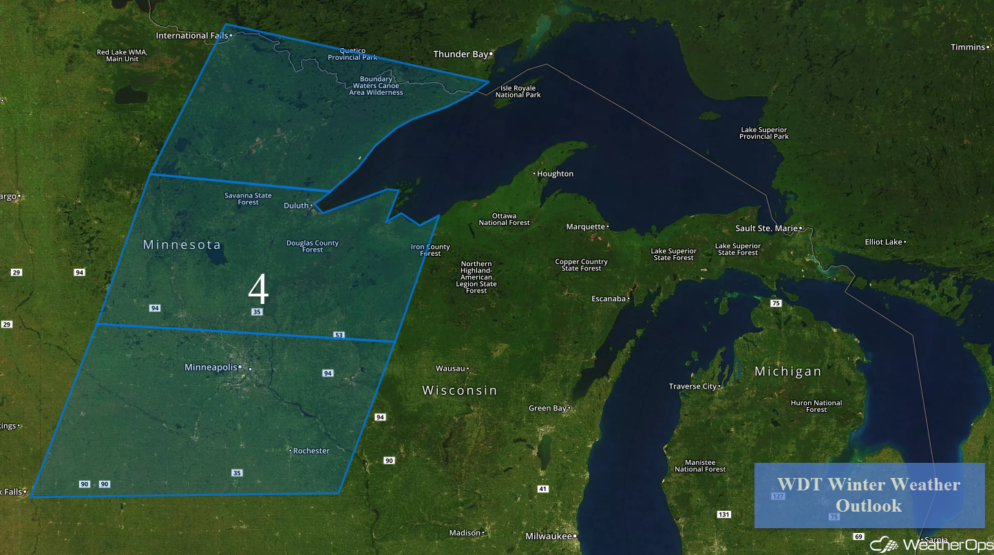 Region 4
Excessive Rainfall Continuing from the Southern Plains into the Ohio Valley through Saturday
A stationary front will remain in place across the Southern Plains into the Ohio Valley through Friday, allowing for continued rainfall. Three day rainfall totals of 4-7 inches with locally higher amounts in excess of 8 inches are forecast. This will allow for a continued risk for flooding and flash flooding.
Major Cities in Region: Dallas, TX, Shreveport, LA, Memphis, TN, Evansville, IN, Cincinnati, OH
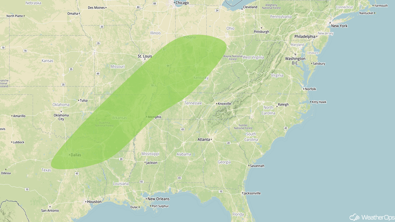 Excessive Rainfall Risk Outline for Wednesday through Friday
A Look Ahead
As another area of low pressure develops on Saturday, heavy to excessive rainfall will continue for portions of the Ozarks into the Ohio Valley. This will allow for a continued threat for flooding and flash flooding. Across the Central Plains and Midwest, snow is expected to develop. This snow may be heavy at times with snow accumulations ranging 3-6 inches and locally higher amounts in excess of 8 inches.
That is a brief look at current weather hazards. We can provide you site-specific weather forecast information to protect your staff and assets and to assess your weather risk. Try a 7-day demo right away and learn how timely precision weather information can enhance your bottom line.
