National Weather Summary for Wednesday, August 10, 2016
by David Moran, on Aug 10, 2016 11:56:36 AM
Severe thunderstorms will be possible on Wednesday across the Northern Plains and Upper Midwest as an area of low pressure moves across the region. Across New England, a cold front will be the focal point for thunderstorm development. Heavy rain will continue along the Gulf Coast as an area of low pressure moves along the coast. Monsoonal thunderstorms will continue across portions of Arizona. As the area of low pressure over the Plains continues to progress eastward on Thursday, thunderstorms will be possible across the Central Plains and western Great Lakes. The heavy rain along the Gulf Coast will spread into the Lower Mississippi Valley on Thursday and continue into Friday. By Friday, thunderstorms will be possible across portions of New England. Heavy rain will be possible for portions of the South Central Plains ahead of a slow moving cold front.
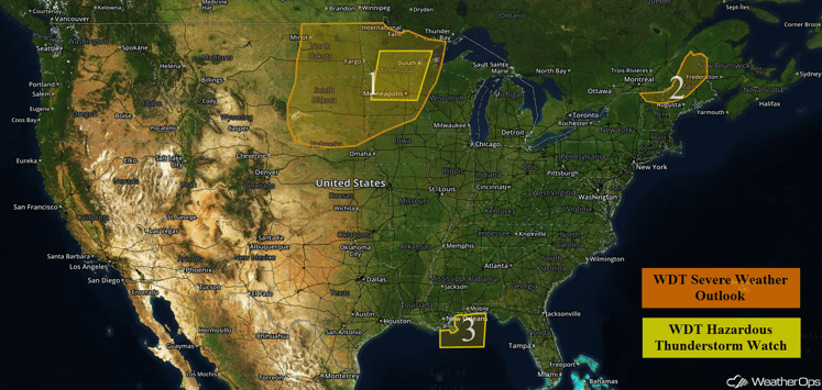
US Hazards
Region 1
There are two areas of thunderstorm activity that are forecast across Region 1 on Wednesday. The first area is currently located across portions of Northern North Dakota and Minnesota associated with a warm front moving northeastward across the region. Some of this thunderstorm activity is ongoing, however, additional activity is expected later this afternoon as instability builds due to daytime heating. This, combined with ample wind shear, is expected to result in an increase in thunderstorm activity in terms of coverage and intensity. The primary hazards associated with any thunderstorms across this region will be strong winds, large hail, and an isolated tornado or two. The second area for thunderstorm development will be further west and south across portions of northern Nebraska and South Dakota as a cold front progresses across the region. Ample moisture combined with moderate to strong instability and wind shear will lead to an increase in coverage and intensity during the afternoon hours especially just ahead of the cold front. Primary impacts with any thunderstorm that develops will be strong winds, large hail, and an isolated tornado or two.
Major Cities in Region: Bismarck, ND, Minneapolis, MN, Pierre, SD, Sioux City, IA
Update 12:11pm CDT: Severe thunderstorms capable of large hail and damaging winds are currently moving through portions of southeastern South Dakota.
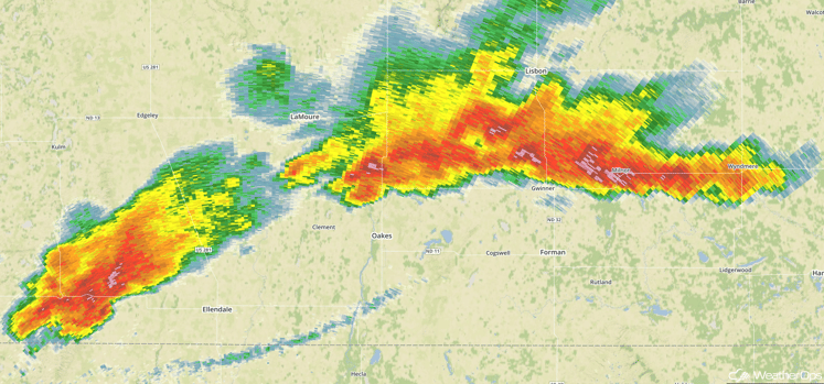
Radar 12:11pm CDT
Update 1:33pm CDT: A Severe Thunderstorm Watch is in effect for portions of Minnesota, North Dakota, and South Dakota until 8pm CDT.
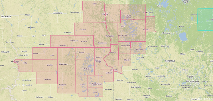
Watch Outline
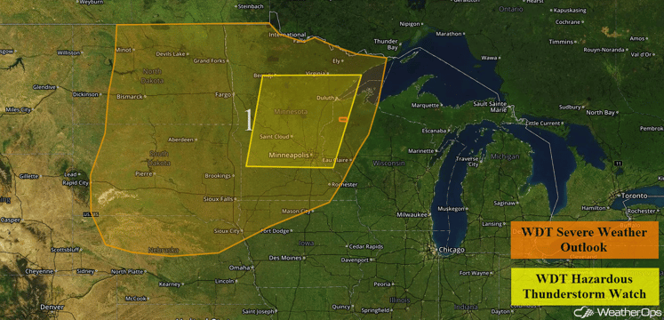
Region 1
Region 2
A cold front moving through Region 2 will be the focus for the development of strong to severe thunderstorms. As the cold front approaches the region, moderate instability will build as a result of daytime heating ahead of the front. This instability combined with moderate wind shear across the region will result in an increase in coverage and intensity of thunderstorms later this afternoon and into the early evening. The primary hazards with any thunderstorms that develop will be strong winds, as well as some hail.
Major Cities in Region: Presque Isle, ME
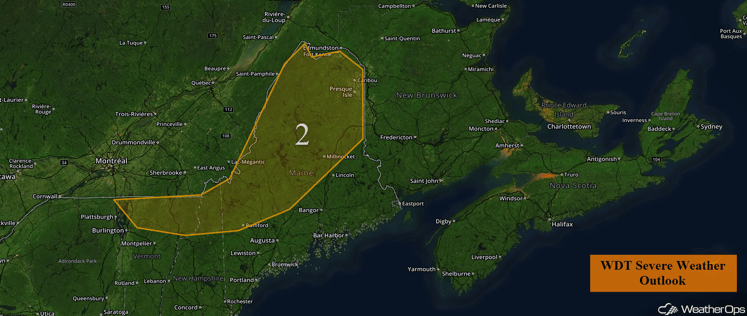
Region 2
Region 3
Widespread thunderstorm activity is expected to persist across Region 3 during the morning hours. While widespread severe weather is not anticipated, some of the stronger thunderstorms could produce winds in excess of 40 mph and locally rough seas. Thunderstorms may begin to weaken somewhat during the afternoon hours, but at least isolated to scattered activity will be likely through the rest of the day.
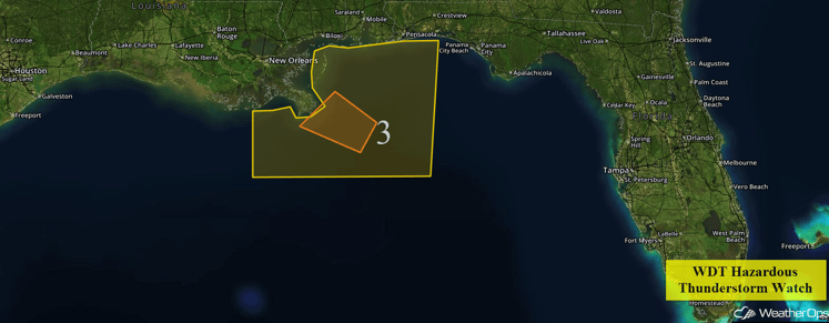
Region 3
Excessive Rainfall Possible for the Gulf Coast on Wednesday
Deep tropical moisture will remain in place along the Gulf Coast today. An upper level low over the Southeast will move slowly westward, allowing for continued shower and thunderstorm activity. Widespread rainfall accumulations of 2-3 inches will be likely across coastal portions of southeast Louisiana, Mississippi, Alabama, and the western Florida Panhandle, which could lead to some flash flooding.
Major Cities in Region: New Orleans, LA, Mobile, AL, Pensacola, FL, Tallahassee, FL
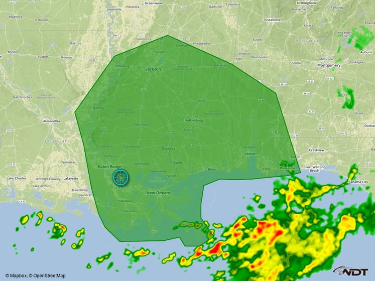
Excessive Rainfall Outline for Wednesday
Excessive Rainfall Possible Wednesday for Portions of Arizona
Monsoonal moisture will continue to stream into the Desert Southwest today. Daytime heating should allow thunderstorms to develop during the afternoon and evening hours, which will tap into this rich moisture. Thunderstorms will be capable of producing locally heavy downpours, resulting in rainfall accumulations of over two inches in some locations.
Major Cities in Region: Flagstaff, AZ, Phoenix, AZ, Tucson, AZ
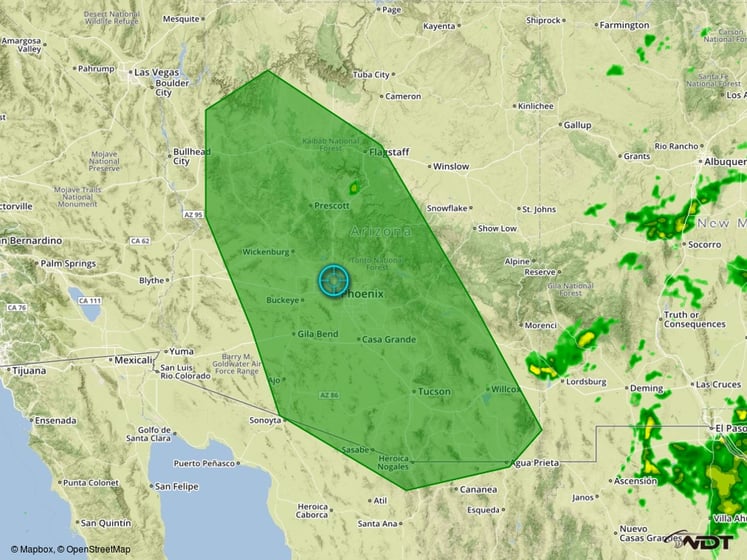
Excessive Rainfall Outline for Wednesday
Strong to Severe Thunderstorms Possible for Portions of the Central Plains and Western Great Lakes on Thursday
Thunderstorms are forecast to develop along and ahead of a cold front moving into the region on Thursday. Modest instability and wind shear in place across the region may allow for a few strong to severe thunderstorms. While there remains some uncertainty in where the most favorable conditions for severe thunderstorms will be, strong to severe thunderstorms will be possible across this region on Thursday. In addition to the severe weather threat, widespread rainfall accumulations of 1-2 inches can be expected, with locally higher amounts in excess of 3 inches possible in some locations.
Major Cities in Region: North Platte, NE, Omaha, NE, Des Moines, IA, Minneapolis, MN, Milwaukee, WI
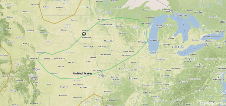
SPC Convective Outlook for Thursday
Excessive Rainfall Possible for Gulf Coast and Lower Mississippi Valley on Thursday and Friday
Widespread heavy rainfall will continue across portions of the northern Gulf Coast on Thursday and spread into the Lower Mississippi Valley on Friday. Very heavy rainfall will be likely in some areas with total rainfall totals of 4-8 inches with isolated higher amounts as high as 12 inches. Given the multiple days of heavy rain, flash flooding will be a significant concern.
Major Cities in Region: New Orleans, LA, Jackson, MS, Mobile, AL
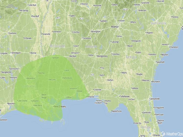
Excessive Rainfall Risk Outline for Thursday and Friday
Strong to Severe Thunderstorms Possible Friday for Upstate New York into New England
Thunderstorms may develop on Friday in the wake of a warm front moving northward into southern portions of Quebec and Ontario. While moderate wind shear is expected to be in place across this region, low instability should prevent much in the way of organized severe weather; however, the moderate shear should be sufficient for the development of a few isolated severe thunderstorms on Friday afternoon.
Major Cities in Region: Rochester, NY, Syracuse, NY, Boston, MA, Augusta, ME
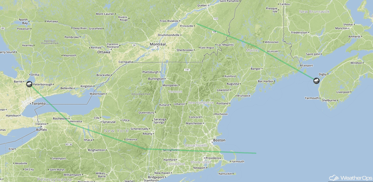
SPC Convective Outlook for Friday
Excessive Rainfall Possible for Portions of the South Central Plains on Friday
Thunderstorms will develop on Friday ahead of a slow moving cold front. While widespread heavy rainfall is not expected at this time, a few thunderstorms could produce locally heavy rainfall in excess of two inches.
Major Cities in Region: Tulsa, OK, Joplin, MO
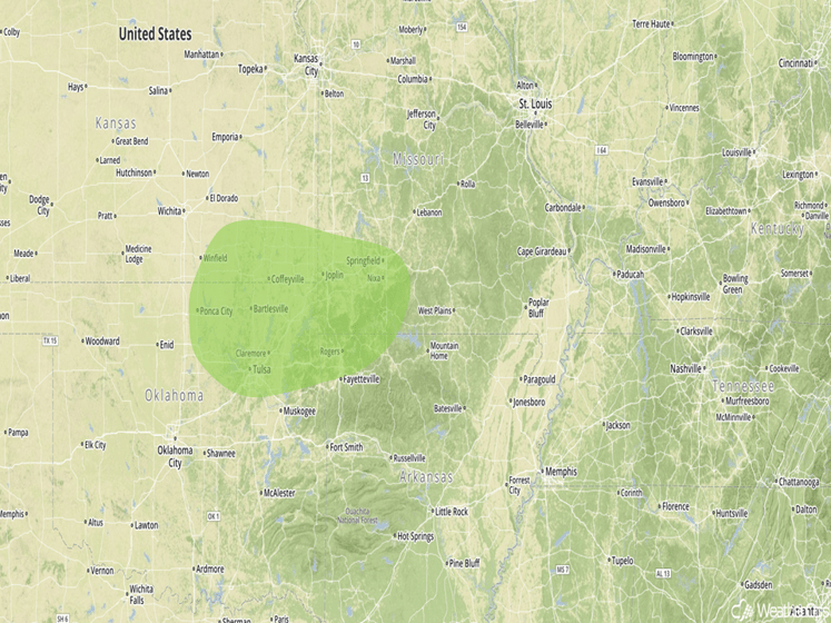
Excessive Rainfall Risk Outline for Friday
This is just a brief look at current weather hazards. We can provide you site-specific forecast information for the purpose of protecting your personnel and assets. Try a 7-day demo right away and learn how timely precision weather information can enhance your bottom line.


