


by David Moran, on Oct 30, 2018 10:28:06 AM
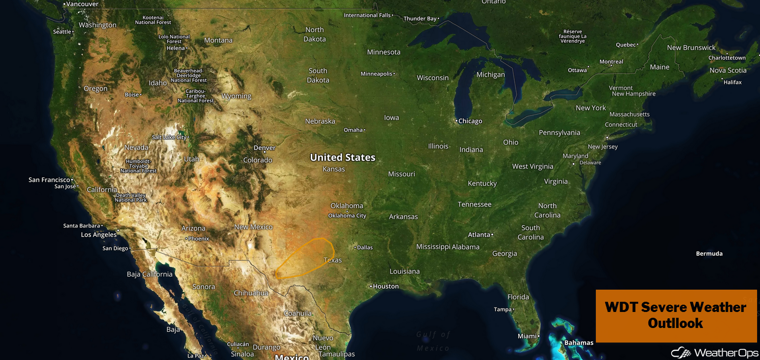
A cold front will be the focus for thunderstorm development across western Texas on Tuesday.
- Potential for Thunderstorms Tuesday across Western Texas
- Thunderstorms from Texas to the Lower Mississippi Valley on Wednesday
- Excessive Rainfall Wednesday from East Texas to the Ohio Valley
- Snow for Colorado and Northern New Mexico Wednesday and Thursday
- Potential for Thunderstorms Thursday across the Southeast
- Risk for Excessive Rainfall from the Central Gulf Coast to the Lower Great Lakes on Thursday
- Tropical Update
US Hazards
Potential for Thunderstorms Tuesday across Western Texas
Thunderstorms may develop across portions of western Texas tonight ahead of a cold front. With moist air ahead of the front and the approach of an upper level trough, conditions will be favorable for the development of thunderstorms. Large hail will be the primary hazard, but there will also be a potential for damaging winds.
Major Cities in Region: Midland, TX, Abilene, TX
Thunderstorm Risk for Tuesday
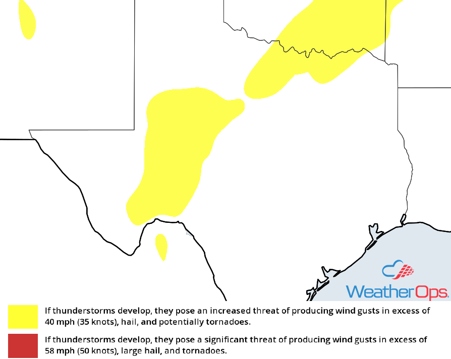
Thunderstorms from Texas to the Lower Mississippi Valley on Wednesday
An intensifying area of low pressure and associated cold front will move across the South Central Plains, allowing for the development of thunderstorms from Texas into the Lower Mississippi Valley on Wednesday. Conditions will be favorable for the development of severe thunderstorms, both supercells and possibly a squall line. Large hail, damaging winds, and tornadoes will be potential hazards with these storms.
Major Cities in Region: San Antonio, TX, Austin, TX, Dallas, TX, Houston, TX, Shreveport, LA, Baton Rouge, LA, Jackson, MS, New Orleans, LA
SPC Convective Outlook for Wednesday
Excessive Rainfall Wednesday from East Texas to the Ohio Valley
The cold front described above will likely produce widespread showers and thunderstorms along and ahead of it. With deep moisture spreading northward from the Gulf of Mexico, there will be a risk for excessive rainfall across the region. Rainfall amounts of 1-3 inches with locally higher amounts in excess of 5 inches are forecast, leading to an increased risk for flooding.
Major Cities in Region: Dallas, TX, Fort Smith, AR, Little Rock, AR, Paducah, KY, Evansville, IN
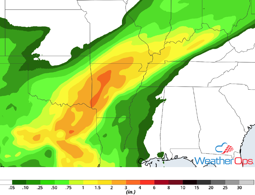
Rainfall Accumulation for Wednesday
Snow for Colorado and Northern New Mexico Wednesday and Thursday
An upper level disturbance will likely bring heavy snow to the higher elevations of the Rockies across Colorado and New Mexico Wednesday and Thursday. Snowfall totals could be in excess of a foot in the highest elevations. In the lower elevations, accumulations will generally be less than 3 inches.
Major Cities in Region: Santa Fe, NM, Trinidad, CO
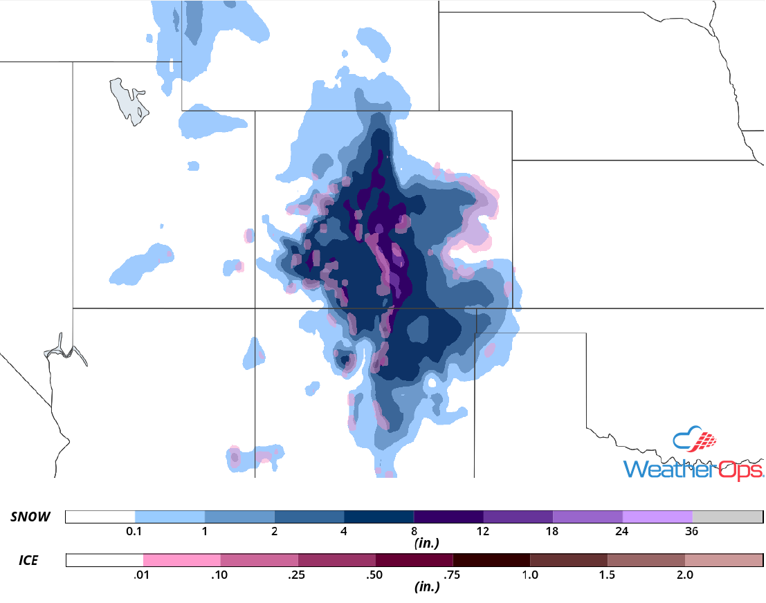
Snow Accumulation for Wednesday and Thursday
Potential for Thunderstorms Thursday across the Southeast
A cold front will continue to move eastward across the Southeast on Thursday, allowing for the development of strong to severe thunderstorms along and ahead of it. A line of thunderstorms may be ongoing during the morning, with additional activity expected during the afternoon and evening. Large hail, damaging winds, and tornadoes will be potential hazards with any severe storm.
Major Cities in Region: New Orleans, LA, Mobile, AL, Montgomery, AL, Panama City, FL Tallahassee, FL
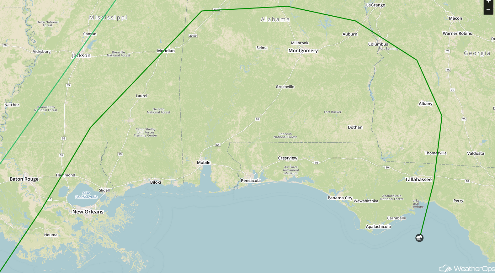
SPC Convective Outlook for Thursday
Risk for Excessive Rainfall from the Central Gulf Coast to the Lower Great Lakes on Thursday
As the cold front described above continues to move eastward on Thursday, widespread showers and thunderstorms will spread across the region along and ahead of the front. There will be a potential for heavy rain on Thursday with widespread amounts of 1-2 inches and locally higher amounts in excess of 4 inches expected. This could lead to the potential for flooding, especially in areas that receive heavy rain on Wednesday.
Major Cities in Region: New Orleans, LA, Evansville, IN, Indianapolis, IN, Cincinnati, OH, Columbus, OH, Cleveland, OH
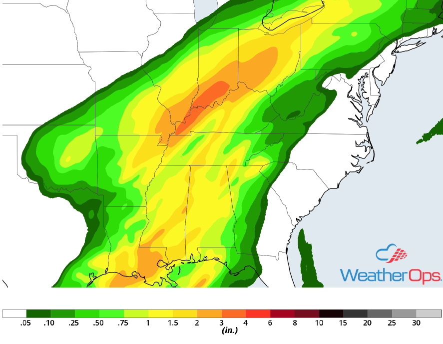
Rainfall Accumulation for Thursday
Tropical Update
Hurricane Oscar is 455 miles east-southeast of Bermuda and is moving north-northeastward at 14 mph. Oscar is forecast to accelerate toward the north-northeast or northeast during the next couple of days. Maximum sustained winds are near 100 mph with higher gusts. A gradual weakening trend is forecast to begin tonight and Oscar is expected to become a powerful extratropical low over the north-central Atlantic by late Wednesday.
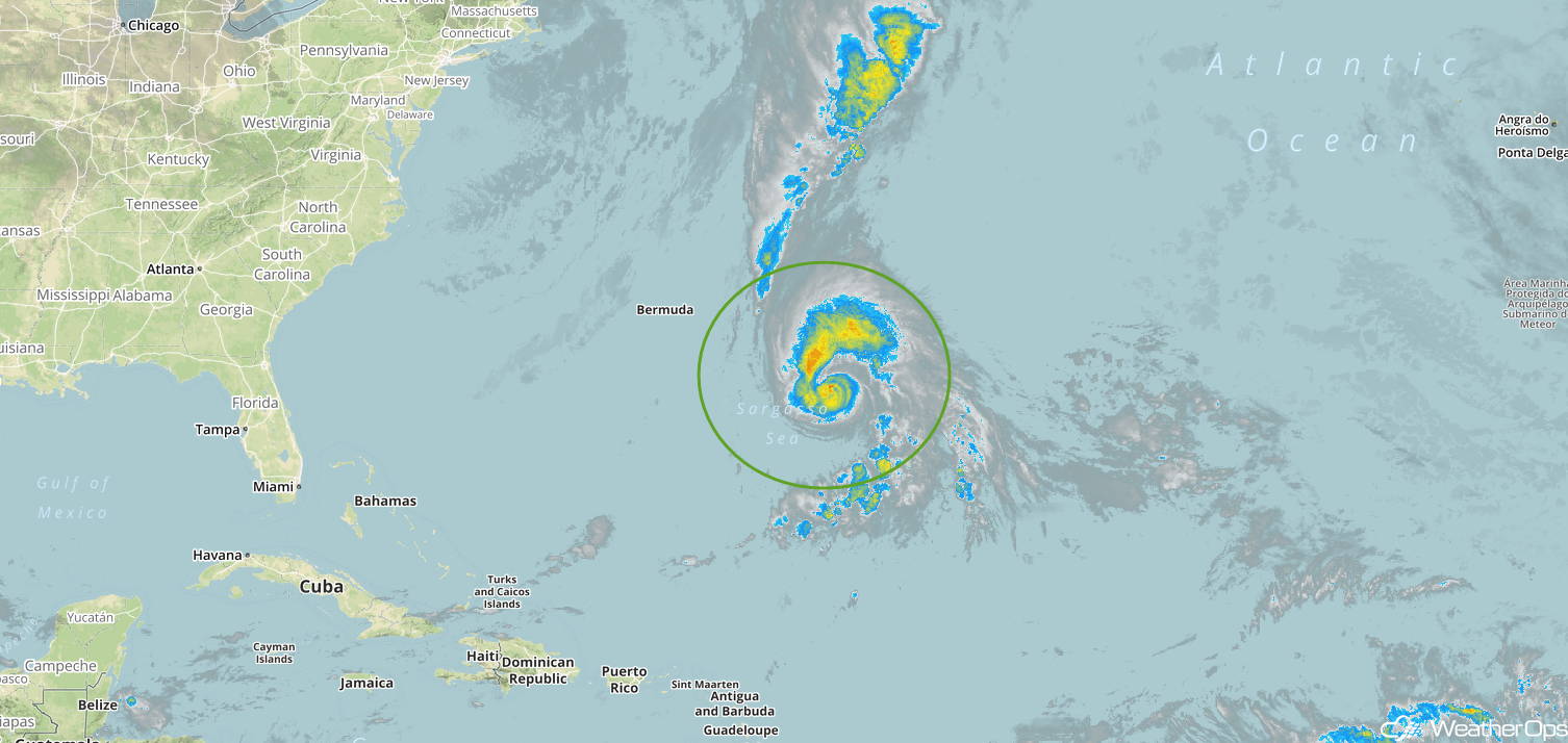
Enhanced Infrared Satellite
A Look Ahead
Showers and thunderstorms are forecast along the East Coast on Friday as a cold front continues to move eastward. An area of low pressure will bring snow to portions of the Northern Rockies on Saturday. By late Saturday, snow will begin to move into the Dakotas. On Sunday, showers will extend from the Great Lakes southward into Texas. Heavy rain and thunderstorms may develop across the Mid Mississippi Valley Monday.
