


by David Moran, on Jun 13, 2017 10:48:35 AM
Thunderstorms may develop on Tuesday from the Midwest into the Northeast along a stalled front. Continuing thunderstorms across Montana will bring the potential for excessive rainfall.
- Thunderstorms for the Plains on Tuesday
- Strong to Severe Thunderstorms on Tuesday from the Midwest into the Northeast
- Excessive Rainfall for Portions of Montana on Tuesday
- Thunderstorm Potential on Wednesday across the Midwest, Southern Plains, and Mid Atlantic
- Risk for Thunderstorms across the Ohio Valley on Thursday
 US Hazards

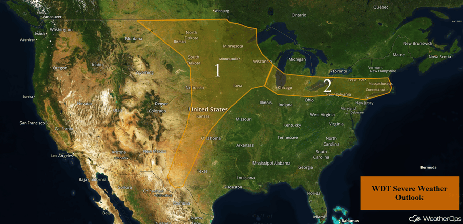
Thunderstorms for the Plains on Tuesday
Storms are expected to develop today ahead of an area of low pressure and cold front stretching from the Dakotas into the Southern Plains. Any discrete thunderstorms may produce tornadoes, but storms should eventually congeal into a line and move northeastward. Winds will become the strongest after the line has developed.
Further south into the Southern Plains, thunderstorms will be more scattered. A few storms may produce large hail and damaging winds during the late afternoon and early evening before weakening.
Major Cities in Region: Odessa, TX, Lubbock, TX, Amarillo, TX, Dodge City, KS, Wichita, KS, Omaha, NE, Des Moines, IA, Madison, WI, Sioux Falls, SD, Pierre, SD, Minneapolis, MN, Bismarck, ND, Fargo, ND, Duluth, MN
 Region 1
Strong to Severe Thunderstorms on Tuesday from the Midwest into the Northeast
Rich moisture combined with daytime heating will create enough instability for the development of thunderstorms along a nearly stationary front across the region. Storms will develop during the early afternoon and will move out of the region. Significant severe weather is not expected, but a few isolated severe storms may develop.
Update 12:03pm EDT: Severe thunderstorms capable of small hail and damaging winds in southern Ohio.
 Radar 12:03pm EDT
Update 12:31pm EDT: Severe thunderstorm capable of hail and damaging winds SE of Charleston, WV.
 Radar 12:31pm EDT
Update 2:12pm EDT: Severe thunderstorm capable of small hail and damaging winds north of Poughkeepsie, NY.
 Radar 2:12pm EDT
Update 2:36pm EDT: Severe thunderstorms capable of hail and damaging winds in eastern Ohio.
 Radar 2:36pm EDT
Update 2:52pm EDT: Severe thunderstorms capable of hail and damaging winds between Cleveland, OH and Columbus, OH.
 Radar 2:52pm EDT
Major Cities in Region: Milwaukee, WI, Chicago, IL, Detroit, MI, Cleveland, OH, New York, NY, Boston, MA
 Region 2
Excessive Rainfall for Portions of Montana on Tuesday
Overnight showers and thunderstorms across western Montana will continue Tuesday as an upper level low remains over the Northern High Plains. Rainfall totals of 1-2 inches with locally higher amounts in excess of 3 inches will be possible, resulting in some minor flooding and local runoff.
Major Cities in Region: Great Falls, MT
 Excessive Rainfall Risk Outline for Tuesday
Thunderstorm Potential on Wednesday across the Midwest, Southern Plains, and Mid Atlantic
Warm, moist air will be in place on Wednesday, stretching from Oklahoma and the Missouri Valley, northward, into the Great Lakes, and eastward into the Mid Atlantic. This area will be bounded by a stalled front over the Great Lakes and an approaching cold front to the west. Scattered showers and thunderstorms may develop with hail and damaging winds being the primary hazards. A slightly higher threat will exist across Wisconsin where large hail and severe winds are expected.
Major Cities in Region: Oklahoma City, OK, Kansas City, MO, Minneapolis, MN, St. Louis, MO, Milwaukee, WI, Chicago, IL, Indianapolis, IN, Cincinnati, OH, Charleston, WV, Raleigh, NC, Washington, DC
 SPC Convective Outlook for Wednesday
Risk for Thunderstorms across the Ohio Valley on Thursday
The severe weather threat will diminish quite a bit by Thursday as the weather pattern transitions to more of a late summer pattern. High pressure will build into the Central US. A weak cold front pushing through the Ohio Valley may allow for the development of isolated thunderstorms, but no significant severe weather is expected. Small hail and severe wind gusts will be the primary hazards with any storms that do develop.
Major Cities in Region: Evansville, IN, Indianapolis, IN, Cincinnati, OH, Charleston, WV, Pittsburgh, PA
 SPC Convective Outlook for Thursday
A Look Ahead
Showers and thunderstorms should increase across the Northeast on Friday as a warm front moves northward across the region. While severe impacts are not expected, a few storms may produce gusty winds and locally heavy rainfall. The threat for thunderstorms will continue through the weekend.
This is just a brief look at current weather hazards. We can provide you site-specific weather forecast information for the purpose of protecting your personnel and assets and to assess your weather risk. Try a 7-day demo right away and learn how timely precision weather information can enhance your bottom line.
