


by David Moran, on Jul 24, 2018 10:46:33 AM
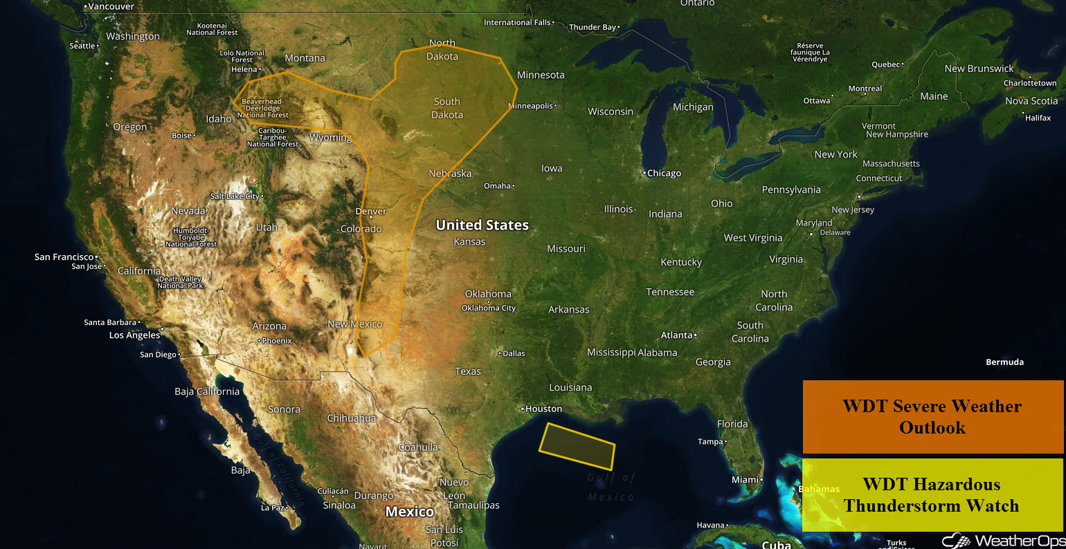
Thunderstorms will continue across the central Gulf of Mexico through early Tuesday afternoon as ample instability and moisture remain in place. A weak area of low pressure may develop over Montana and move into the Northern Plains, bringing a risk for thunderstorms from the Northern Plains to the Front Range. The risk for excessive rainfall will continue for the Northeast and Mid Atlantic as an upper level trough stalls over the region through Wednesday.
- Continued Thunderstorms through Tuesday afternoon for the Central Gulf of Mexico
- Thunderstorms from the Northern Plains to the Front Range on Tuesday
- Excessive Rainfall through Wednesday for the Northeast and Mid Atlantic
- Risk for Thunderstorms from the Upper Midwest through the Central Plains on Wednesday
- Potential for Excessive Rainfall Wednesday and Thursday for Colorado and the Front Range
- Thunderstorm Potential for the Rockies on Thursday
- Thunderstorms Thursday across the Lower Great Lakes
US Hazards
Continued Thunderstorms through Tuesday afternoon for the Central Gulf of Mexico
Ample instability and moisture will remain in place across portions of the central Gulf of Mexico this morning. Southward moving storms have begun to develop along outflow boundaries from yesterday's activity. With favorable conditions ahead of these storms, additional thunderstorms and further strengthening of ongoing thunderstorms is forecast into the afternoon as they continue to track southward. Damaging winds and waterspouts will be the primary hazards with the stronger storms.
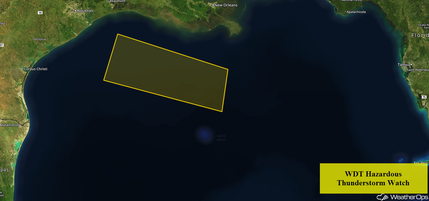
WDT Hazardous Thunderstorm Watch
Thunderstorms from the Northern Plains to the Front Range on Tuesday
There will be a risk of thunderstorms from the Northern Plains into the Front Range on Tuesday as a weak area of low pressure develops over Montana. Weak instability is expected to develop ahead of the low during the afternoon and early evening. With upslope flow pumping moisture northward, isolated to widely scattered showers and thunderstorms are forecast across Montana, Wyoming, and the Rockies late this afternoon. These storms will continue to move eastward with some of these thunderstorms becoming strong to severe. Damaging winds and large hail will be the primary hazards with these storms.
Major Cities in Region: Colorado Springs, CO, Rapid City, SD, Aberdeen, SD
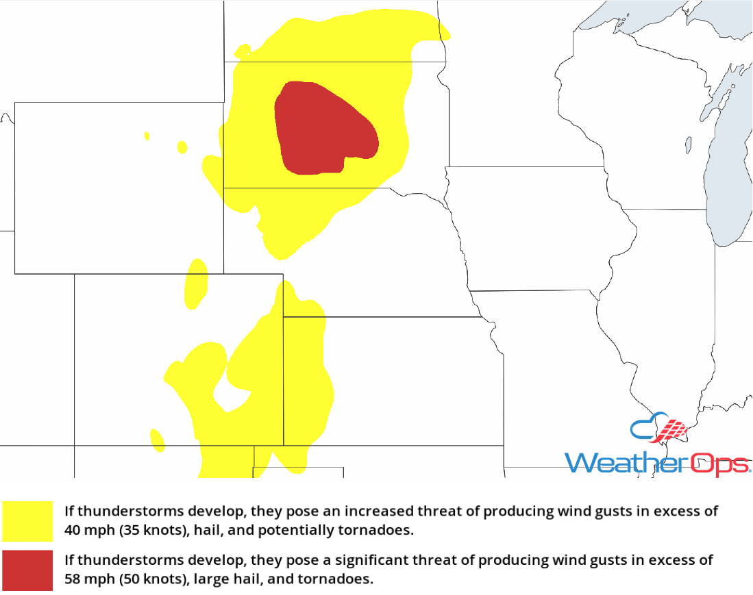
Thunderstorm Risk for Tuesday
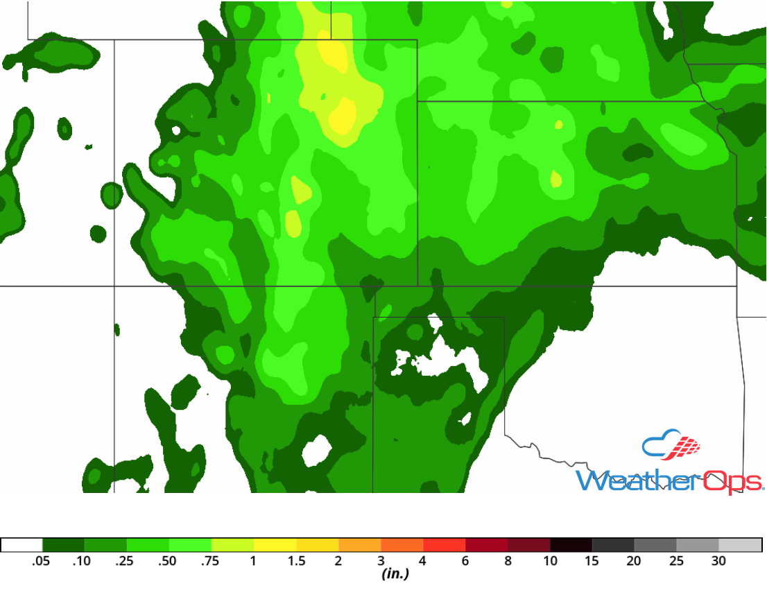
Excessive Rainfall through Wednesday for the Northeast and Mid Atlantic
An upper level trough will remain stalled over the region. Conditions will be favorable for slow moving shower and thunderstorm activity from the Carolinas northward into the Northeast. Rainfall accumulations of 2-4 inches with locally higher amounts in excess of 5 inches are forecast. Given previous heavy rainfall over the last few days, there will be a risk for flooding and flash flooding.
Major Cities in Region: Richmond, VA, Washington, DC, Baltimore, MD, Philadelphia, PA New York, NY, Albany, NY
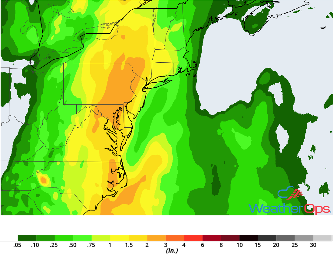
Rainfall Accumulation through Wednesday
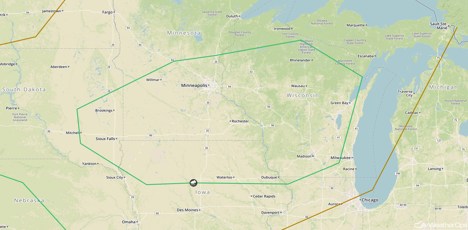
Risk for Thunderstorms from the Upper Midwest through the Central Plains on Wednesday
The area of low pressure that is forecast to bring thunderstorms to portions of the Northern Plains and Front Range on Tuesday will continue to move east-northeastward into the Great Lakes on Wednesday. The associated cold front will track east and southeastward throughout the day into portions of the Upper Midwest and Central Pains. Ahead of this front, instability will build. With the front providing lift, scattered shower and thunderstorm activity is forecast along and ahead of the cold front. Some storms could become strong to severe with large hail, damaging winds, and tornadoes all potential hazards. The threat will transition to damaging winds after sunset when thunderstorms merge into clusters.
Major Cities in Region: Sioux Falls, SD, Minneapolis, MN, Waterloo, IA, Madison, WI, Green Bay, WI
SPC Convective Outlook for Wednesday
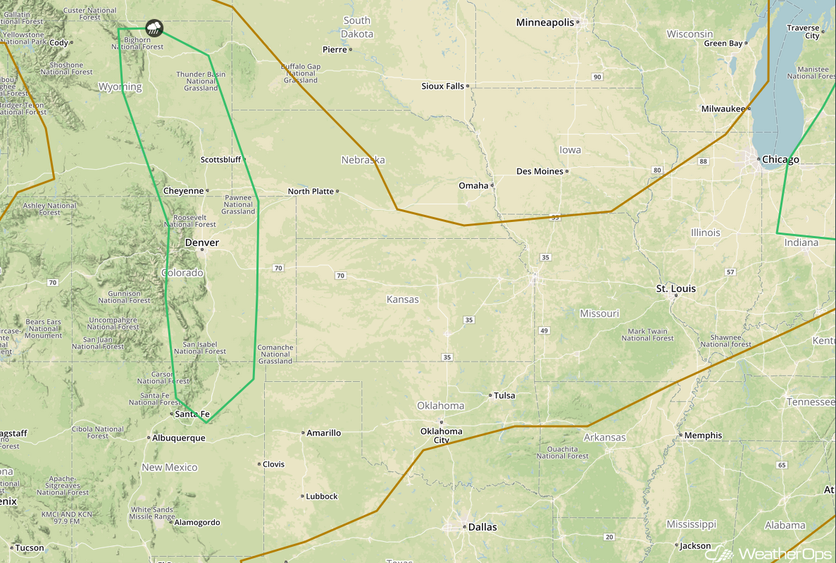
Potential for Excessive Rainfall Wednesday and Thursday for Colorado and the Front Range
Ample low level moisture will remain in place across the Rockies and Front Range Wednesday and Thursday as southeasterly upslope flow continues to bring moisture northward from the Gulf of Mexico. A frontal boundary will slowly move southward and stall. This will act as a focus for showers and thunderstorms during the afternoon and evening hours on both days. With instability building during the afternoon hours, scattered slow moving thunderstorms will track south to southeastward. This will bring a potential for moderate to heavy rainfall across the region. Rainfall totals of 1-2 inches with locally higher amounts in excess of 3 inches are forecast across the region between Wednesday and Thursday. This will allow for a risk for excessive runoff and widespread flash flooding.
Major Cities in Region: Denver, CO, Colorado Springs, CO
Rainfall Accumulation for Wednesday and Thursday
Thunderstorm Potential for the Rockies on Thursday
Upslope flow will continue to bring ample low level moisture to portions of the Rockies on Thursday. As daytime heating increases, instability will build across the region during the afternoon hours. With a weak stationary front in place and this instability, widely scattered strong to severe thunderstorms are forecast during the afternoon on Thursday. Damaging winds and large hail will be the primary hazards with the stronger storms. Activity will dissipate after sunset with the loss of daytime heating.
Major Cities in Region: Colorado Springs, CO, Denver, CO, Cheyenne, WY, Scottsbluff, NE
SPC Convective Outlook for Thursday
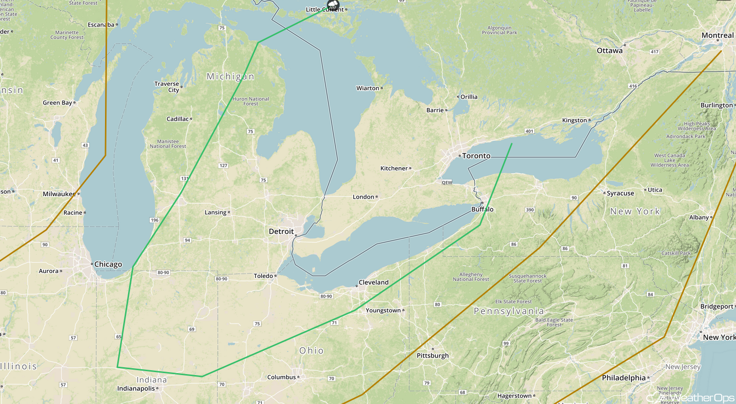
Thunderstorms Thursday across the Lower Great Lakes
A cold front will make its way across the Great Lakes on Thursday with instability building ahead of the front. With increasing wind shear, conditions will be favorable for shower and thunderstorm development along and ahead of the front. Damaging winds and hail will be the primary hazards with these storms.
Major Cities in Region: Lansing, MI, Toledo, OH, Detroit, MI, Cleveland, OH
SPC Convective Outlook for Thursday
A Look Ahead
As the cold front described above continues to move eastward on Friday, showers and thunderstorms may develop from the Northeast into the Ohio Valley. Thunderstorms are forecast to develop across the Central Plains and Missouri Valley on Saturday. This activity may continue into Sunday. By Monday, activity will shift into the Mid Mississippi Valley.
