


by David Moran, on Jul 17, 2018 11:13:15 AM
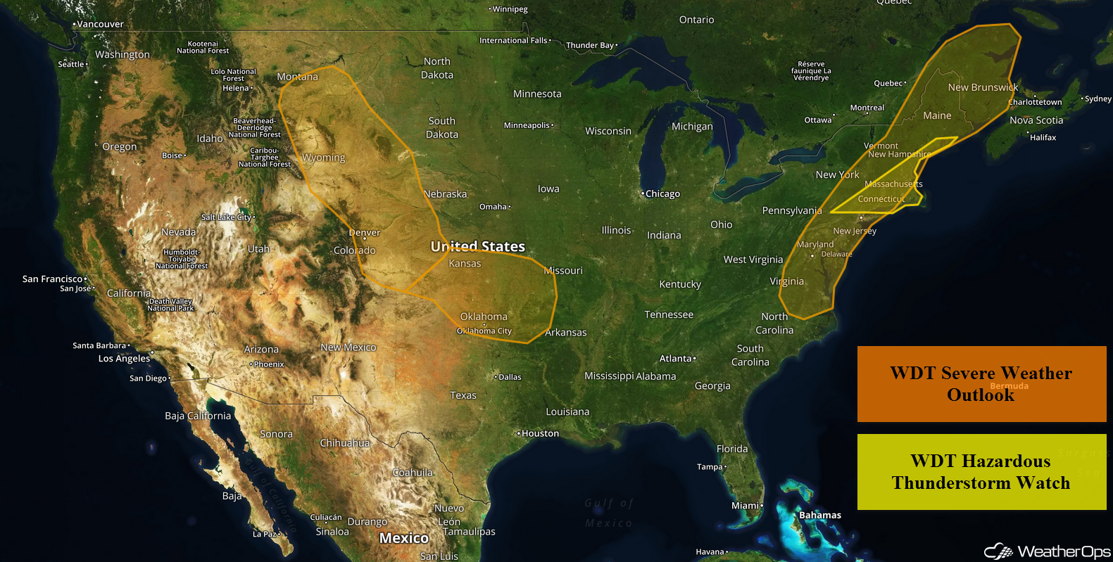
A cold front will be the focus for the development of thunderstorms across the Northeast on Tuesday. These thunderstorms will also have the potential to produce heavy to excessive rainfall. Thunderstorms may develop across the High and Central Plains during the afternoon as instability increases. Some storms may produce heavy to excessive rainfall. The risk for excessive rainfall will continue across portions of the Southeast as monsoonal moisture remains in place.
- Thunderstorms for the Northeast on Tuesday
- Excessive Rainfall Tuesday for the Northeast
- Potential for Thunderstorms across the High and Central Plains on Tuesday
- Risk for Excessive Rainfall on Tuesday across the High Plains
- Excessive Rainfall for the Southwest on Tuesday
- Thunderstorms Wednesday for the Central and Northern Plains
- Potential for Excessive Rainfall from the Central and Northern Plains into the Upper Mississippi Valley on Wednesday
- Thunderstorm Potential Thursday for the Upper Mississippi Valley
- Excessive Rainfall for the Upper Mississippi Valley Thursday
US Hazards
Thunderstorms for the Northeast on Tuesday
Strong to severe thunderstorms may develop across the Northeast as an upper level trough and cold front move across the region. Scattered showers and thunderstorms are likely throughout the day, however, conditions will become more favorable during the afternoon as instability builds. This will allow for the development of strong to severe thunderstorms along and ahead of the front. Strong to damaging winds will be the primary hazard, but an isolated tornado cannot be ruled out. Storms should push offshore by the evening.
Major Cities in Region: Albany, NY, New York, NY, Boston, MA, Portland, ME, Augusta, ME
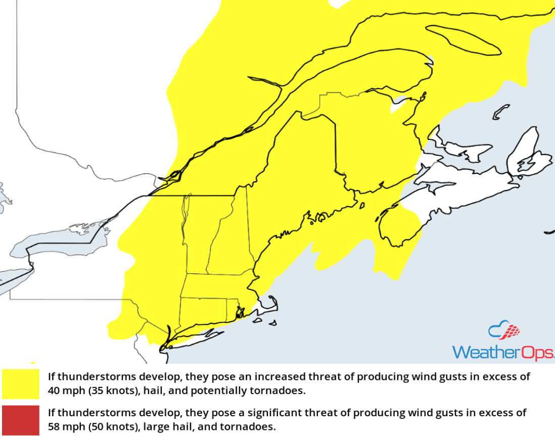
Thunderstorm Risk for Tuesday
Excessive Rainfall Tuesday for the Northeast
In addition to the thunderstorm potential, there will be a risk for excessive rain. Rainfall amounts of 1.00-2.00 inches with locally higher amounts in excess of 2 inches are forecast. Due to previous days' rainfall, there will be an increased risk for flooding and flash flooding.
Major Cities in Region: New York, NY, Bridgeport, CT, Burlington, VT
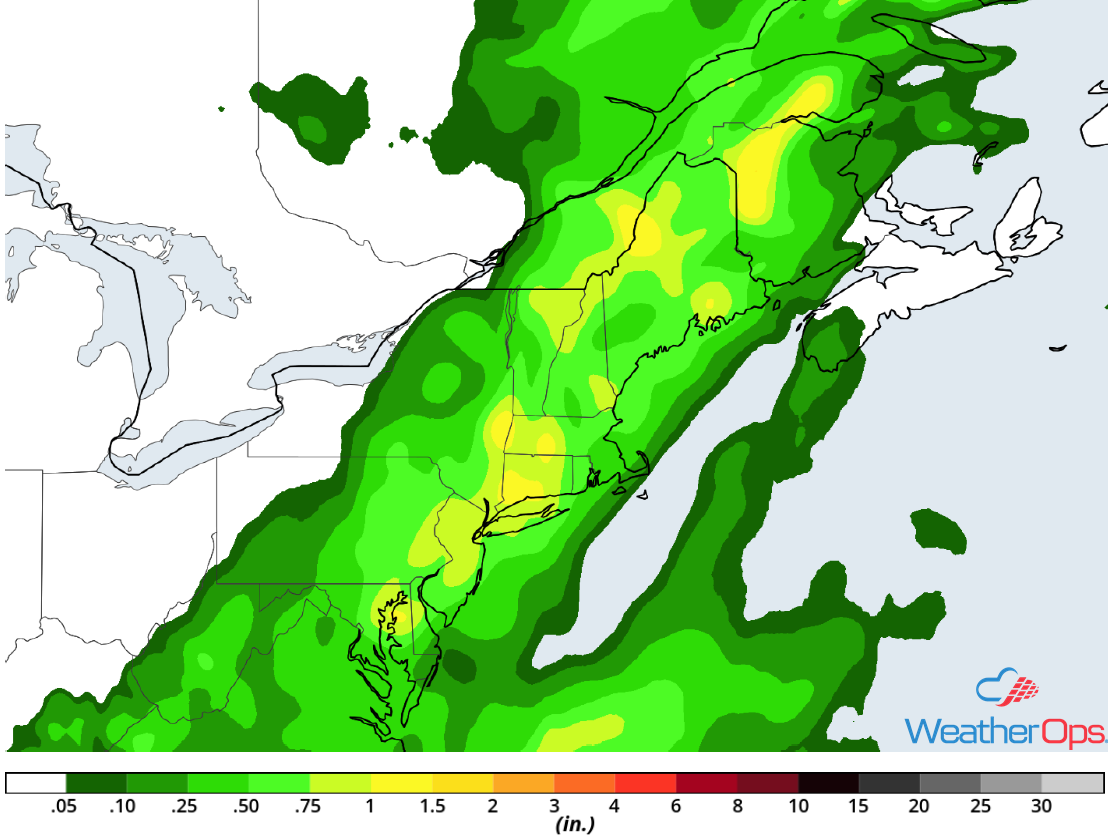
Rainfall Accumulation for Tuesday
Potential for Thunderstorms across the High and Central Plains on Tuesday
An ongoing cluster of thunderstorms moving southeastward across the area will pose a low end wind threat through the morning hours before it weakens. However, by the afternoon, conditions are expected to become favorable for redevelopment of thunderstorms along remnant outflow boundaries from morning activity. Strong to damaging winds and large hail will be the primary hazards with these storms.
Major Cities in Region: Rapid City, SD, North Platte, NE, Goodland, KS
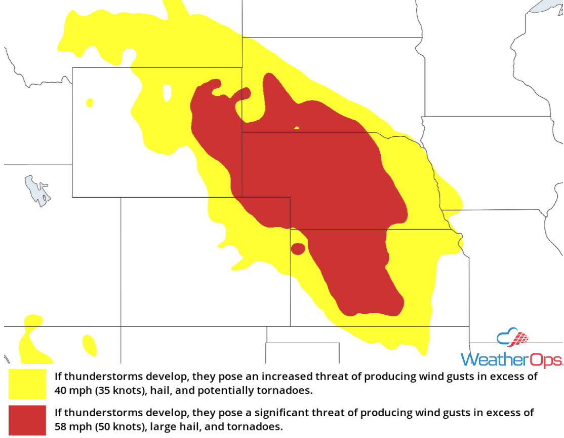
Thunderstorm Risk for Tuesday
Risk for Excessive Rainfall on Tuesday across the High Plains
Some of the thunderstorms described above may have the potential to produce heavy rainfall. Rainfall amounts will range 0.25-0.50 inch with locally higher amounts in excess of 0.75 inch. With rainfall from overnight storms, there will be a risk for localized flash flooding.
Major Cities in Region: Rapid City, SD, North Platte, NE
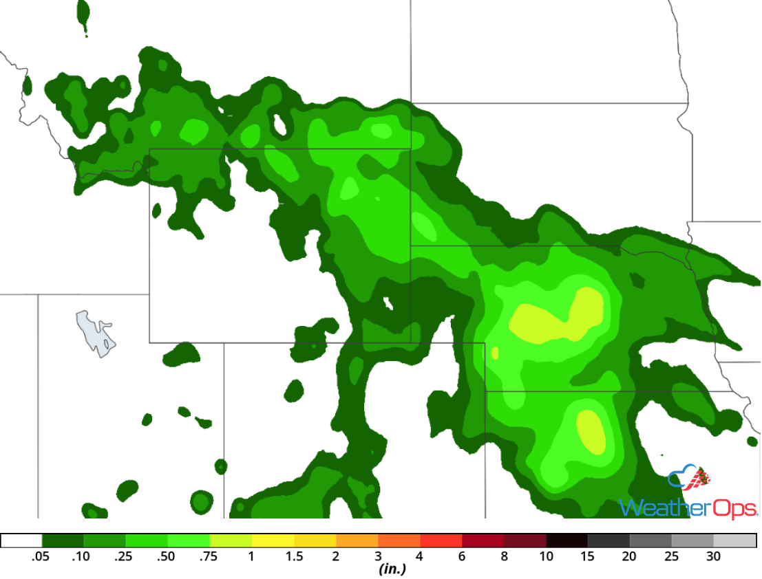
Rainfall Accumulation for Tuesday
Excessive Rainfall for the Southwest on Tuesday
Monsoonal moisture will remain in place across the region on Tuesday. Scattered slow moving showers and thunderstorms are forecast to develop across the higher terrain, leading to a threat of flooding and flash flooding, especially areas that have received multiple days of rain. Rainfall amounts will range 0.10-0.25 inch, with locally higher amounts in excess of 0.50 inch.
Major Cities in Region: Flagstaff, AZ, Phoenix, AZ, Tucson, AZ
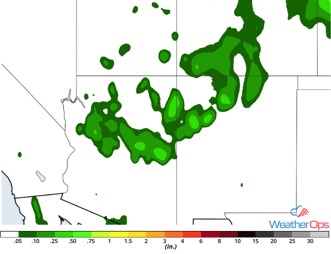
Rainfall Accumulation for Tuesday
Thunderstorms Wednesday for the Central and Northern Plains
The severe weather threat will continue across portions of the Plains on Wednesday as an area of low pressure begins to develop over the Northern Plains. The low will track eastward during the day with scattered strong to severe thunderstorms likely to the south of the low during the afternoon. High winds and hail will be the primary hazards with the stronger storms.
Major Cities in Region: Pierre, SD, Kearney, NE, Sioux Falls, SD, Sioux City, IA, Omaha, NE
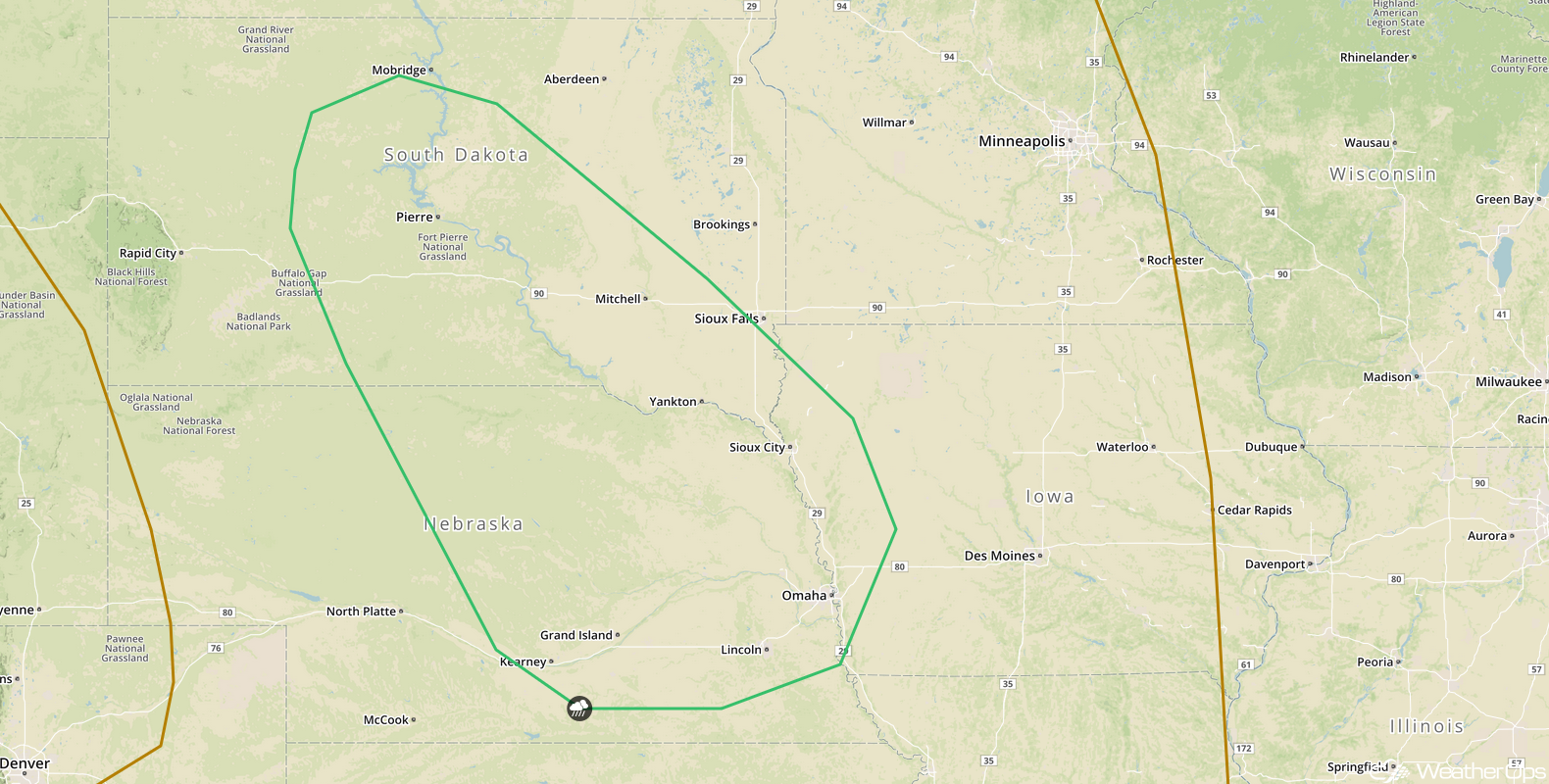
SPC Convective Outlook for Wednesday
Potential for Excessive Rainfall from the Central and Northern Plains into the Upper Mississippi Valley on Wednesday
The thunderstorms described above will have the potential to produce heavy to excessive rainfall. Rainfall amounts will range 0.50-1.50 inches with locally higher amounts.
Major Cities in Region: Pierre, SD, Grand Island, NE, Lincoln, NE, Sioux City, IA, Omaha, NE
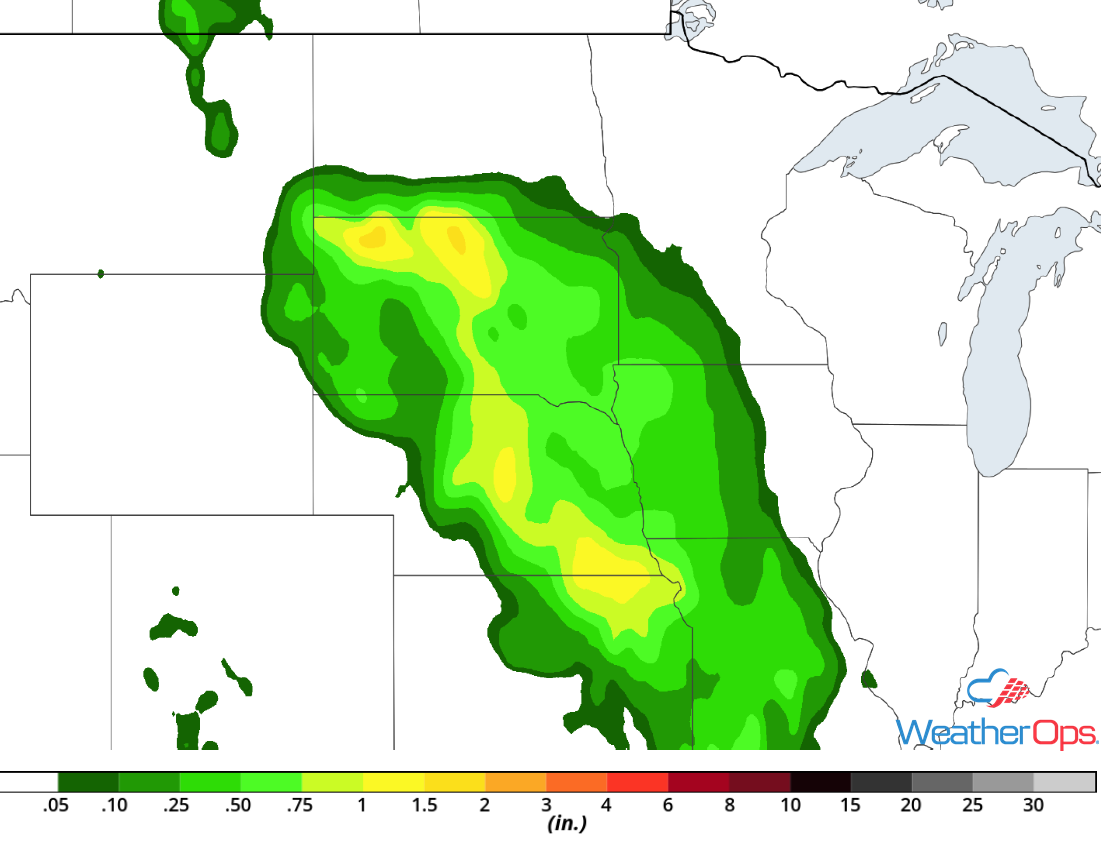
Rainfall Accumulation for Wednesday
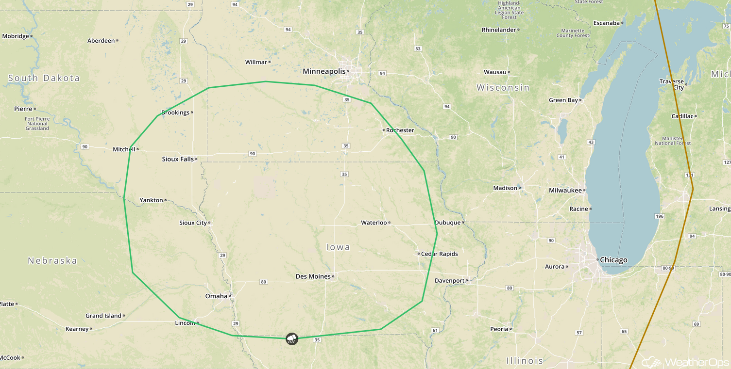
Thunderstorm Potential Thursday for the Upper Mississippi Valley
An area of low pressure is forecast to move eastward on Thursday, allowing for a risk of strong to severe thunderstorms across the Upper Mississippi Valley. Thunderstorms will likely develop across southern Minnesota or northern Iowa during the afternoon. These storms will move southeastward during the late afternoon and evening with severe winds and hail the primary hazards.
Major Cities in Region: Sioux Falls, SD, Sioux City, IA, Omaha, NE, Des Moines, IA, Rochester, MN, Cedar Rapids, IA
SPC Convective Outlook for Thursday
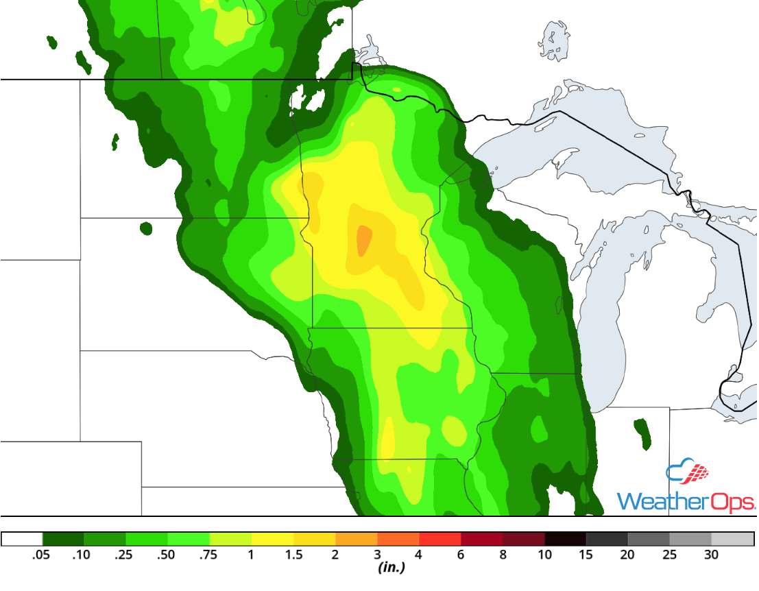
Excessive Rainfall for the Upper Mississippi Valley Thursday
In addition to the severe weather potential described above, there will be a risk for excessive rainfall. Rainfall amounts will range 0.50-1.50 inches with locally higher amounts in excess of 2 inches. This will allow for a risk for flash flooding.
Major Cities in Region: Fargo, ND, Minneapolis, MN, Duluth, MN
Rainfall Accumulation for Thursday
A Look Ahead
As the area of low pressure described above continues to move eastward on Friday, showers and thunderstorms will extend from the Great Lakes into the Southeast. This activity will continue into Saturday. An area of low pressure moving northward along the East Coast late Saturday into Sunday will bring a potential for heavy to excessive rainfall to portions of the Mid Atlantic and Northeast on Sunday. Showers and thunderstorms may continue across the Northeast on Monday as this area of low pressure moves away from the coast.
