National Weather Summary for Tuesday, August 9, 2016
by David Moran, on Aug 9, 2016 12:12:54 PM
A cold front moving out of the Dakotas will be the focus for thunderstorms across portions of the Northern Plains and Upper Midwest on Tuesday. Deep tropical moisture and a weak upper level low will allow for heavy rain across portions of the Ohio Valley and Eastern Great Lakes. Heavy rain will continue across the northeastern Gulf Coast through Thursday, as rich moisture remains in place. Monsoonal showers and thunderstorms will continue through Wednesday across Arizona. An area of low pressure developing over the Northern Plains on Wednesday will allow for the development of thunderstorms across portions of the Northern Plains and Upper Midwest. As the area of low pressure continues to progress eastward, thunderstorms will be possible on Thursday across the Central Plains and Upper Mississippi Valley.
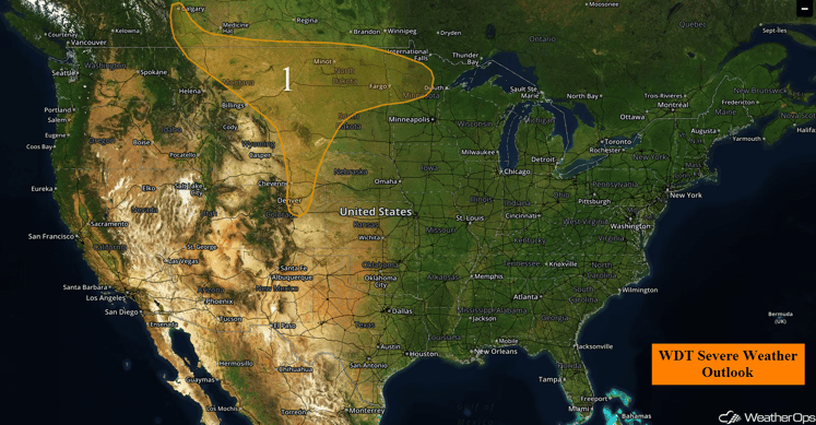
US Hazards
Region 1
An area of low pressure over the Northern Rockies will maintain a strong southwesterly jet stream over the Northern High Plains with the potential for one or two troughs to pass through Region 1 this afternoon and evening. Showers and thunderstorms will be possible, with a few becoming severe. Instability will support thunderstorms capable of large hail, damaging winds, and an isolated tornado or two. Isolated to scattered activity is expected to develop across portions of Alberta and Montana with storm coverage expanding eastward into the Dakotas. Additional development is forecast across North Dakota during the evening hours with a risk for damaging winds. This activity may push into much of northern Minnesota by Wednesday morning. Further south, a few storms will be possible before dark across the Front Range with isolated large hail and winds.
Major Cities in Region: Great Falls, MT, Rapid City, SD, Bismarck, ND, Fargo, ND, Cheyenne, WY, Denver, CO
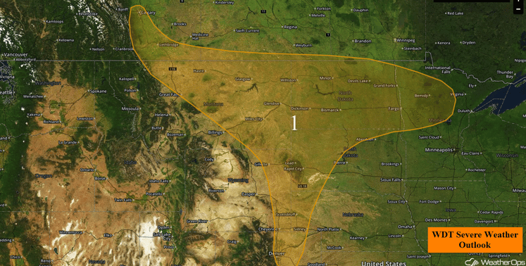
Region 1
Excessive Rainfall Possible Tuesday Across the Ohio Valley and Eastern Great Lakes
Deep tropical moisture will interact with a weak upper level trough digging into the region on Tuesday. Widespread rainfall amounts will likely remain near an inch, but locally higher amounts in excess of 2 inches will be possible.
Major Cities in Region: Cincinnati, OH, Cleveland, OH, Pittsburgh, PA
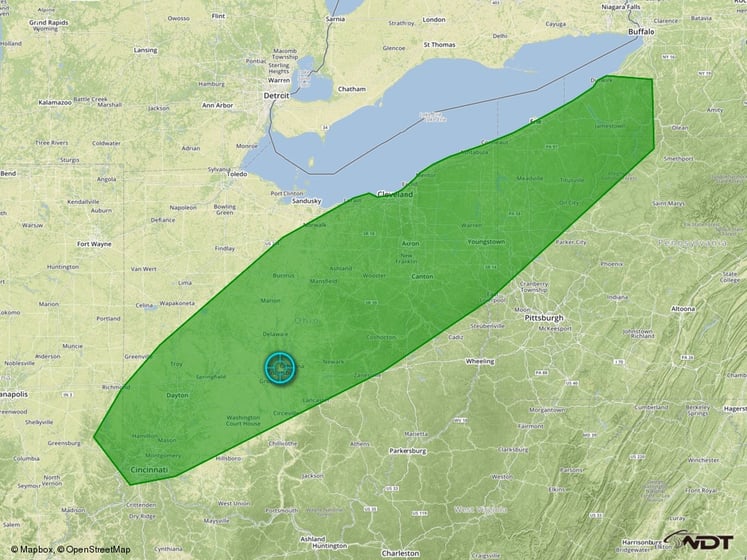
Excessive Rainfall Risk Outline
Excessive Rainfall Possible Tuesday for Northeast Gulf Coast
Very rich moisture remains in place across the Southeast. Thunderstorms continuing today will tap into this rich moisture. Combined with weak upper level winds, these slow moving thunderstorms will be capable of producing very heavy rainfall that could lead to flash flooding. The focus of the heaviest thunderstorms will likely be across the Florida Panhandle, the Florida Big Bend, and southwards to the Tampa Bay area. Rainfall accumulations of 1-2 inches with locally higher amounts in excess of 3 inches will be possible.
Major Cities in Region: Tallahassee, FL, Tampa, FL
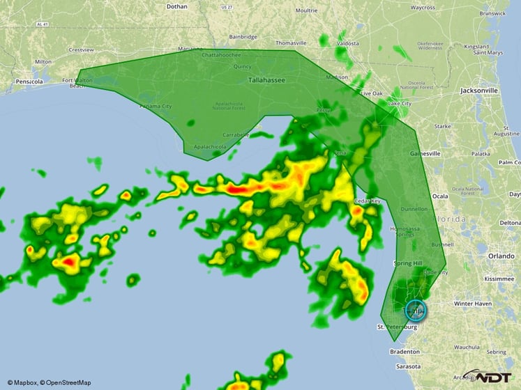
Excessive Rainfal Outline for Tuesday
Excessive Rainfall Possible for Portions of Arizona Tuesday and Wednesday
Monsoonal moisture will continue to flow into the Desert Southwest on Tuesday. Thunderstorms that develop during the afternoon and evening in response to strong daytime heating will tap into this rich, tropical moisture. This will allow for thunderstorms to produce heavy downpours. While the heavy rains should remain localized, 1-2 inches of rain will be possible in some areas, which could lead to flash flooding. Heavy rain will continue into Wednesday; additional accumulations around 0.50 inches and locally heavier amounts in excess of one inch will be possible.
Major Cities in Region: Phoenix, AZ, Tucson, AZ
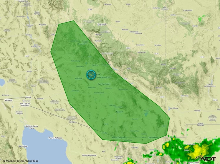
Excessive Rainfall Risk Outline
Strong to Severe Thunderstorms Possible Wednesday for the Northern Plains and Upper Midwest
Thunderstorms will form near and ahead of a developing area of low pressure over the Northern Plains on Wednesday. Strong instability in place across the region will allow for some thunderstorms to become severe. Thunderstorms will begin initially as supercells over the Dakotas with large hail and perhaps a few tornadoes expected to be the main threats. Thunderstorms should quickly merge into a squall line as they push east into Minnesota and eventually western Wisconsin. The threat will transition to primarily damaging winds during the evening hours. In addition to this severe weather threat, heavy rainfall will be possible. Widespread rainfall accumulations of 2-4 inches will be likely with higher amounts in excess of 6 inches possible in some locations.
Major Cities in Region: Bismarck, ND, Aberdeen, SD, Sioux Falls, SD, Minneapolis, MN
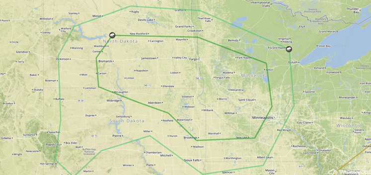
SPC Convective Outlook for Wednesday
Excessive Rainfall Possible for Portions of the Gulf Coast on Wednesday
A weak area of low pressure will drift westward on Wednesday. This will shift the heavy rainfall threat into southeastern Louisiana, coastal portions of Alabama and Mississippi, and the western Florida Panhandle. Widespread rainfall accumulations of around two inches will be likely, with locally higher amounts in excess of four inches possible in some locations.
Major Cities in Region: New Orleans, LA, Mobile, AL, Pensacola, FL
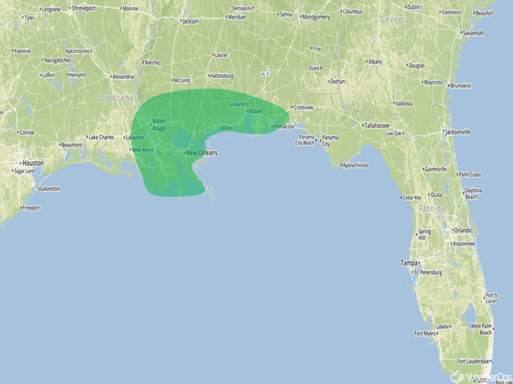
Excessive Rainfall Risk Outline
Strong to Severe Thunderstorms Possible Thursday for the Central Plains and Upper Mississippi Valley
The threat for severe weather will shift slowly to the south and east as a surface low continues across the Great Plains. Thunderstorms are expected to be ongoing during the early morning hours, but will likely weaken by late afternoon. Additional thunderstorm development is expected during the afternoon. Conditions will be favorable for some of these thunderstorms to become severe, with damaging winds the main hazard. In addition to the severe weather threat, locally heavy rainfall accumulations in excess of 2 inches will be possible in some locations.
Major Cities in Region: Denver, CO, Kansas City, MO, Des Moines, IA, Minneapolis, MN
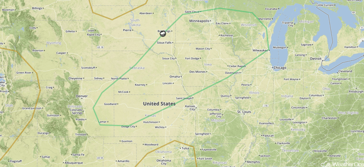
SPC Convective Outlook for Thursday
Excessive Rainfall Possible for Portions of the Gulf Coast on Thursday
The excessive rainfall threat along the Gulf Coast will shift north and west as a weak area of low pressure continues to meander along the coast. Widespread rainfall accumulations of around two inches can be expected across southeastern Louisiana, southern Mississippi, and southwestern Alabama on Thursday. This second day of heavy rainfall could lead to flooding concerns.
Major Cities in Region: Baton Rouge, LA, New Orleans, LA, Mobile, AL
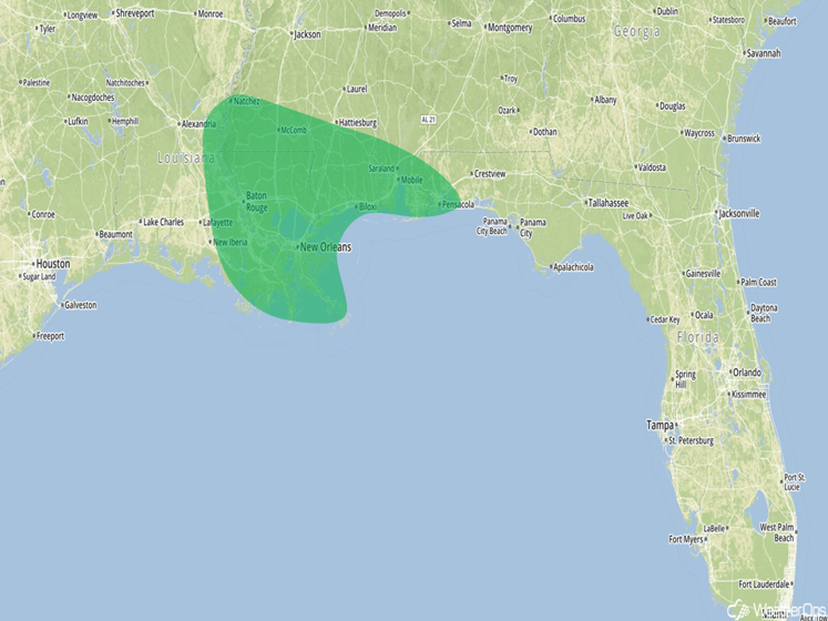
Excessive Rainfall Risk Outline for Thursday
This is just a brief look at current weather hazards. We can provide you site-specific forecast information for the purpose of protecting your personnel and assets. Try a 7-day demo right away and learn how timely precision weather information can enhance your bottom line.


