by David Moran, on Sep 6, 2018 11:11:02 AM
As the remnants of Tropical Storm Gordon continue to move northwestward, heavy to excessive rainfall will continue across Arkansas through Saturday. A stalled front, as well as the remnants of Gordon, will allow for a risk of excessive rainfall through Saturday from the Middle Mississippi Valley into the Ohio Valley. Rich tropical moisture across Texas will pose a risk for heavy rainfall through Saturday. Thunderstorms are forecast to develop across the Northeast on Thursday ahead of a cold front. Some of these storms will have the potential to produce excessive rainfall. A cold front will be the focus for the development of thunderstorms across North Dakota.
- Excessive Rainfall for Arkansas through Saturday
- Potential for Excessive Rainfall through Saturday from the Middle Mississippi Valley through the Ohio Valley
- Excessive Rainfall for Texas through Saturday
- Thunderstorms Thursday across the Northeast
- Risk for Excessive Rainfall for the Northeast on Thursday
- Potential for Thunderstorms Thursday across North Dakota
- Thunderstorms for the Northern High Plains on Saturday
- Tropical Update
US Hazards
Excessive Rainfall for Arkansas through Saturday
The remnants of Tropical Depression Gordon, along with a stalled front over the region, will lead to a risk of excessive rainfall over Arkansas. Rainfall amounts of 4-6 inches with locally higher amounts in excess of 8 inches are expected. As a result, there will be a potential for flooding and flash flooding.
Major Cities in Region: Little Rock, AR, Pine Bluff, AR, Jonesboro, AR
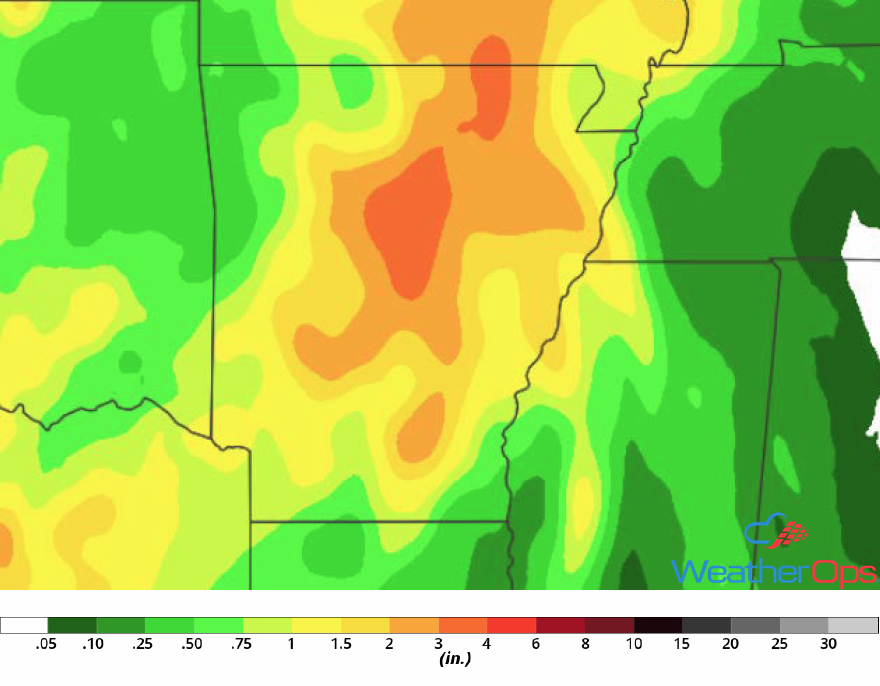
Rainfall Accumulation through Saturday
Potential for Excessive Rainfall through Saturday from the Middle Mississippi Valley through the Ohio Valley
As a front stalls over the Mid Mississippi Valley and into the Ohio Valley, excessive rainfall will be likely as a result of rich moisture and the remnants of Gordon. For Thursday, rainfall will be a result of the stalled front; rainfall accumulations will range 0.75-1.00 inch. On Friday, as tropical moisture moves into the region, rainfall amounts will range 1.50-3.00 inches with locally higher amounts in excess of 4 inches. Going into Saturday, rainfall totals will range 2.50-4.00 inches with locally higher amounts in excess of 6.00 inches. This will result in three day rainfall accumulations of 5-8 inches with locally higher amounts in excess of 12 inches. Flooding and flash flooding will be likely.
Major Cities in Region: Kirksville, MO, Springfield, MO, Indianapolis, IN
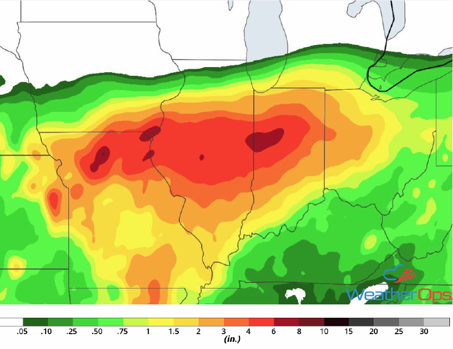
Rainfall Accumulation through Saturday
Excessive Rainfall for Texas through Saturday
Rich tropical moisture is forecast to remain across the region as southeasterly to east-southeasterly winds continue to bring moisture northward. With daytime heating and a stalled front, there will be a risk for heavy to excessive rainfall leading to flash flooding into the weekend. Three day rainfall accumulations of 2-4 inches with locally higher amounts in excess of 6 inches are forecast.
Major Cities in Region: Del Rio, TX, San Antonio, TX, Austin, TX, Dallas, TX
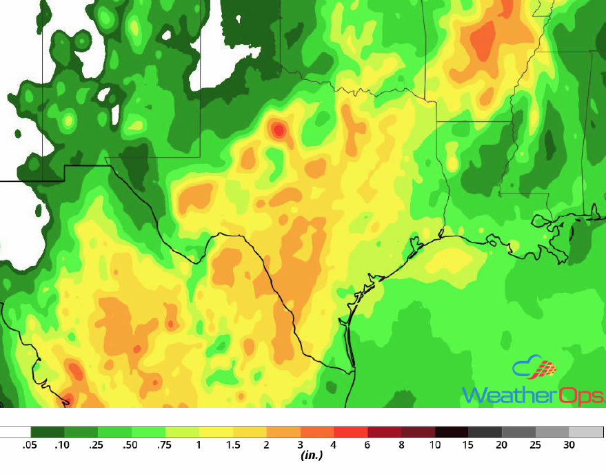
Rainfall Accumulation through Saturday
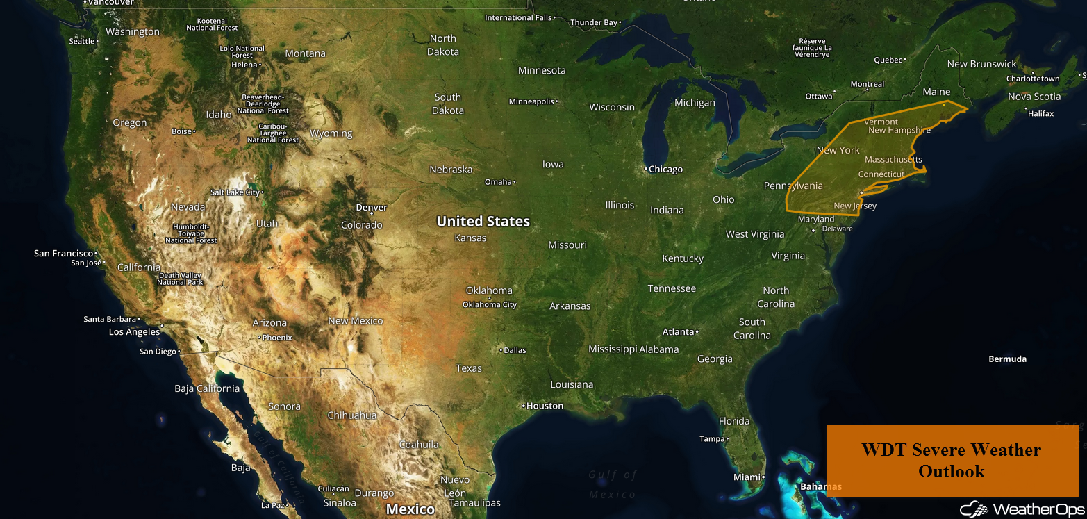
Thunderstorms Thursday across the Northeast
A slow moving cold front is forecast to progress eastward throughout the day, Ahead of the front, plentiful moisture and daytime heating will allow instability to build. As the cold front continues to move eastward, strong to severe thunderstorms may develop along the front. Strong to damaging winds will be the primary hazard with these storms.
Major Cities in Region: Albany, NY, New York, NY, New Haven, CT, Providence, RI
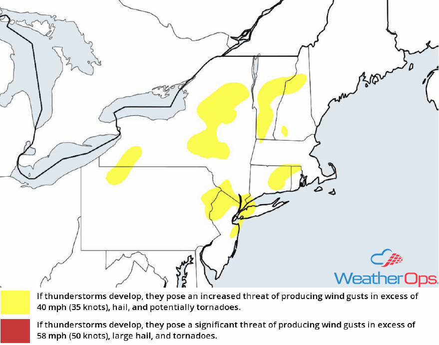
Thunderstorm Risk for Thursday
Risk for Excessive Rainfall for the Northeast on Thursday
In addition to the thunderstorm risk described above, there will be a potential for excessive rainfall. Rainfall amounts of 0.25-0.75 inch with locally higher amounts in excess of 1.25 inches are expected.
Major Cities in Region: State College, PA, Albany, NY, Burlington, VT, New Haven, CT, Providence, RI
Rainfall Accumulation for Thursday
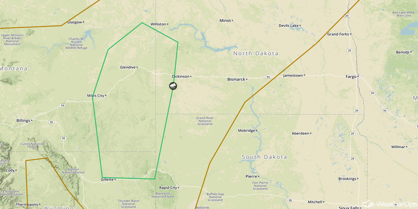
Potential for Thunderstorms Thursday across North Dakota
Moisture will increase across the region as southerly winds persist throughout the day ahead of a cold front. With warming temperatures and increasing moisture, instability will build. This will lead to the development of widely scattered thunderstorms. Strong winds and large hail will be the primary hazards with these storms.
Major Cities in Region: Bismarck, ND
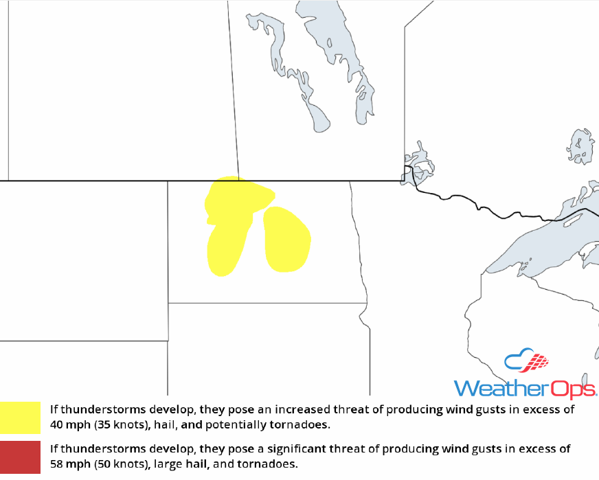
Thunderstorm Risk for Thursday
Thunderstorms for the Northern High Plains on Saturday
An upper level trough is forecast to track to the east over the Rockies throughout the day on Saturday with a lee trough developing in the Northern High Plains. With warm temperatures and moisture in the region, instability is expected to build. Upper level support provided by the trough will allow the development of strong to severe thunderstorms during the late afternoon and evening. Strong winds and large hail will be the primary hazards with these storms.
Major Cities in Region: Glendive, MT
SPC Convective Outlook for Saturday
Tropical Update
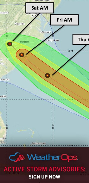
Hurricane Florence (green oval) is 1115 miles east-southeast of Bermuda and is moving northwestward at 10 mph. A turn toward the west-northwest and a decrease in forward speed is expected through Saturday. Florence may begin to move faster toward the west-northwest over the western Atlantic early next week. Maximum sustained winds are 105 mph with higher gusts. Additional weakening is expected over the next day or two however, Florence is expected to remain a hurricane and reintensify over the weekend.
A broad area of low pressure (red oval) is several hundred miles west-southwest of the Cabo Verde Islands. Associated shower and thunderstorm activity has not become any better organized since yesterday and there is no well defined center. However, environmental conditions are expected to be conducive for development. A tropical depression is expected to develop over the next few days while this system moves slowly westward or west-northwestward.
A tropical wave (blue oval) is forecast to move off the west coast of Africa on Friday. Some development of this system is anticipated afterward and a tropical depression could develop over the weekend or early next week. This system will move westward or west-northwestward.
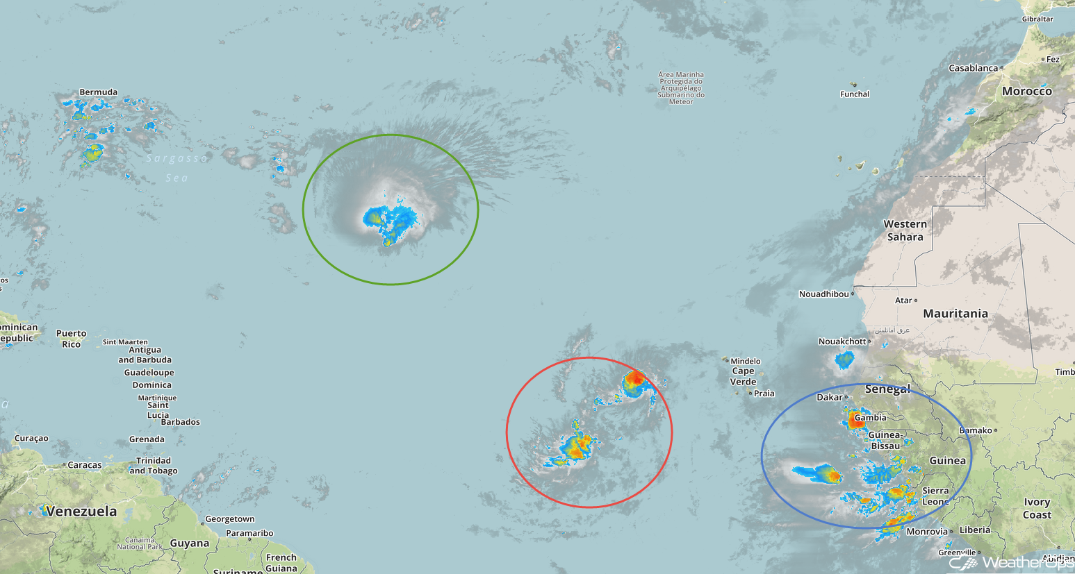
Enhanced Infrared Satellite
A Look Ahead
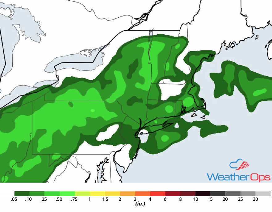
Heavy rain associated with the remnants of Gordon will continue to move across the Ohio Valley and into the Northeast on Sunday. Rainfall amounts of 3-5 inches with locally higher amounts in excess of 6 inches are expected, leading to a potential for flooding. The heaviest rain will continue to move across the Northeast on Monday. A few light showers will remain across the Northeast Tuesday into Wednesday.