


by David Moran, on May 17, 2018 10:52:11 AM
Thunderstorms are forecast to develop across portions of the Plains on Thursday ahead of a dry line. The risk for excessive rainfall will continue for the Mid Atlantic and Central Appalachians through Friday. Across the Northern Plains, there will be a threat for excessive rainfall as an area of low pressure moves across the region.
- Thunderstorms for the Plains on Thursday
- Excessive Rainfall Continuing through Friday across the Mid Atlantic and Central Appalachians
- Risk of Excessive Rainfall for the Northern Plains Thursday
- Thunderstorm Potential Friday for the Great Plains and Front Range
- Excessive Rainfall for the Northern High Plains on Friday
- Risk for Thunderstorms Saturday from the Central Plains to the Mid Mississippi Valley
- Thunderstorms for the Upper Ohio Valley on Saturday
- Excessive Rainfall Saturday for the Northern Plains
 US Hazards

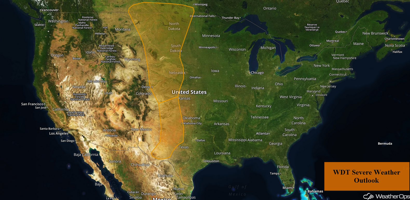
Thunderstorms for the Plains on Thursday
As an upper level trough continues to progress slowly eastward toward the Plains today, isolated to scattered thunderstorm development is anticipated across a large portion of the area this afternoon and evening. Frontal boundaries associated with the surface low, as well as a dry line, will provide the forcing for thunderstorm development. As instability increases with daytime heating, conditions are expected to become favorable for strong to severe thunderstorms. Damaging winds and hail will be the primary hazards, but an isolated tornado cannot be ruled out.
Major Cities in Region: Lubbock, TX, Amarillo, TX, Goodland, KS, Scottsbluff, NE, Rapid City, SD, Bismarck, ND
 Thunderstorm Risk for Thursday
Excessive Rainfall Continuing through Friday across the Mid Atlantic and Central Appalachians
A stalled front will remain in place, bringing scattered to widespread showers and thunderstorms to the region through Friday. Deep moisture in place will allow for an excessive rainfall threat; rainfall amounts of 2-3 inches with locally higher amounts in excess of 5 inches are expected. Given rain from previous days, a flooding threat will continue through the end of the week.
Major Cities in Region: Richmond, VA, Washington, DC, Baltimore, MD
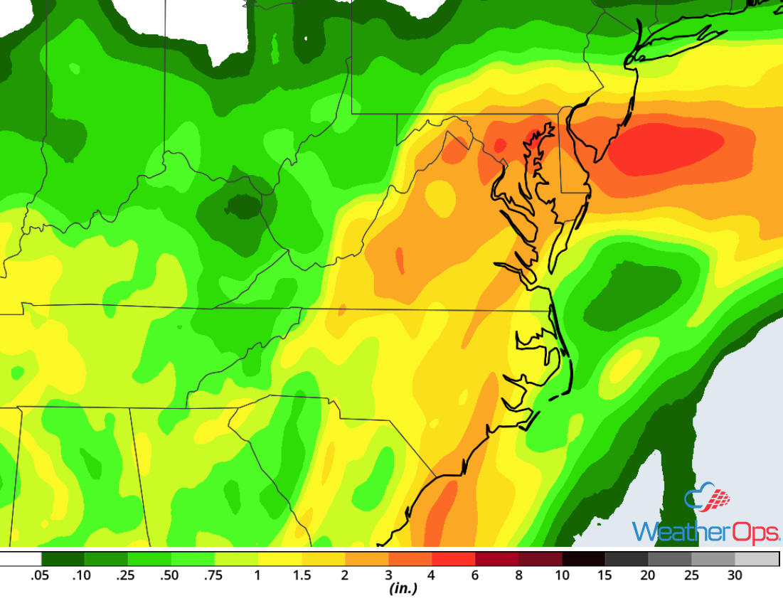 Rainfall Accumulation through Friday
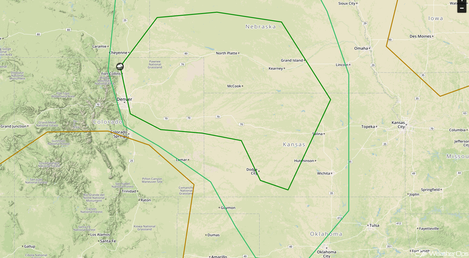
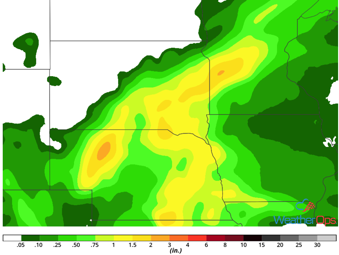
Risk of Excessive Rainfall for the Northern Plains Thursday
A slow moving upper level trough and associated surface low will allow for the development of showers and thunderstorms across portions of the Northern Plains, mainly beginning tonight and continuing into the overnight hours. Showers and thunderstorms across the region will bring a potential for excessive rainfall to the region. Rainfall amounts of 1-2 inches with locally higher amounts in excess of 3 inches are forecast. This could lead to areas of localized flooding.
Major Cities in Region: Rapid City, SD, Bismarck, ND
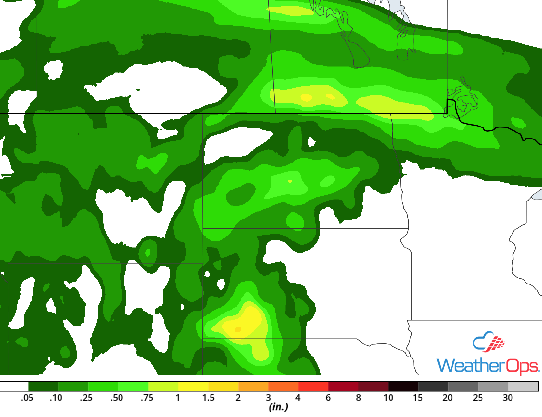 Rainfall Accumulation for Thursday
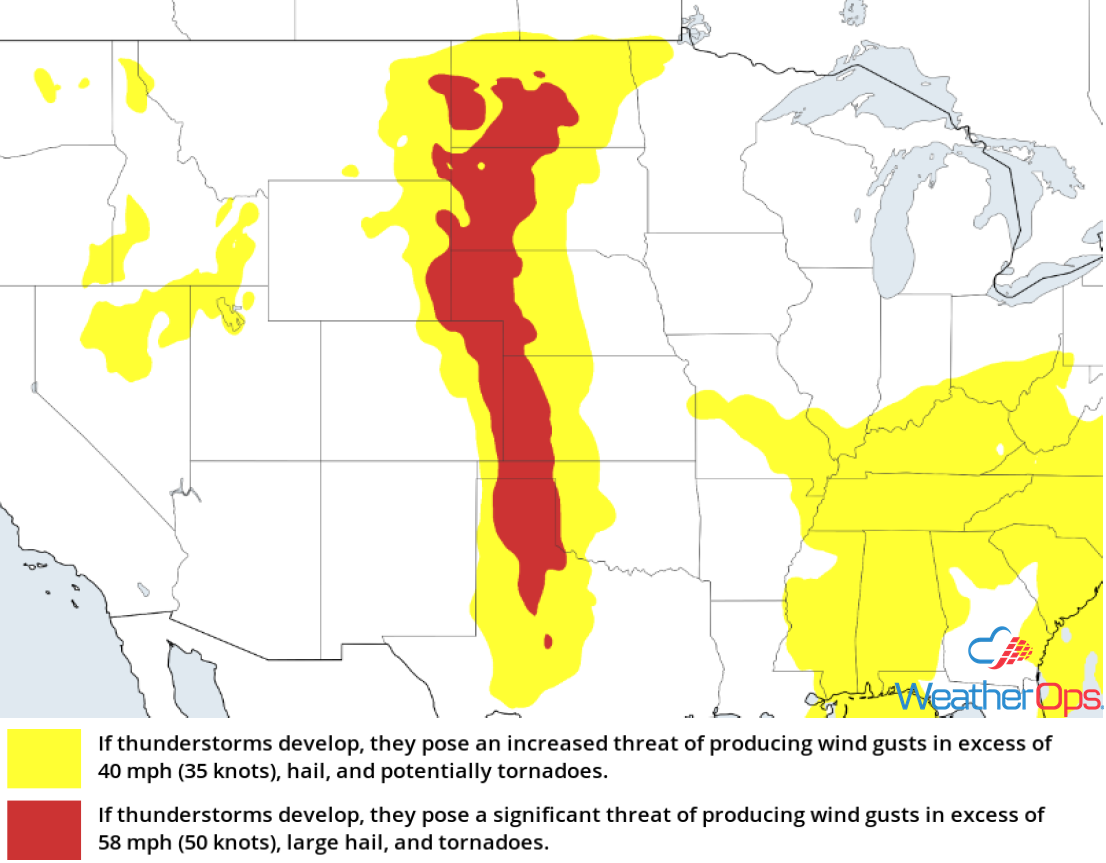
Thunderstorm Potential Friday for the Great Plains and Front Range
A slow moving upper level trough will continue to allow for a thunderstorm potential across the central portions of the country on Friday. An intensifying area of low pressure and associated cold front will provide the focus for thunderstorm development, primarily during the afternoon and evening. Damaging winds and hail will be the primary hazards, but an isolated tornado or two cannot be ruled out.
Major Cities in Region: Goodland, KS, North Platte, NE, Dodge City, KS, Grand Island, NE
 SPC Convective Outlook for Friday
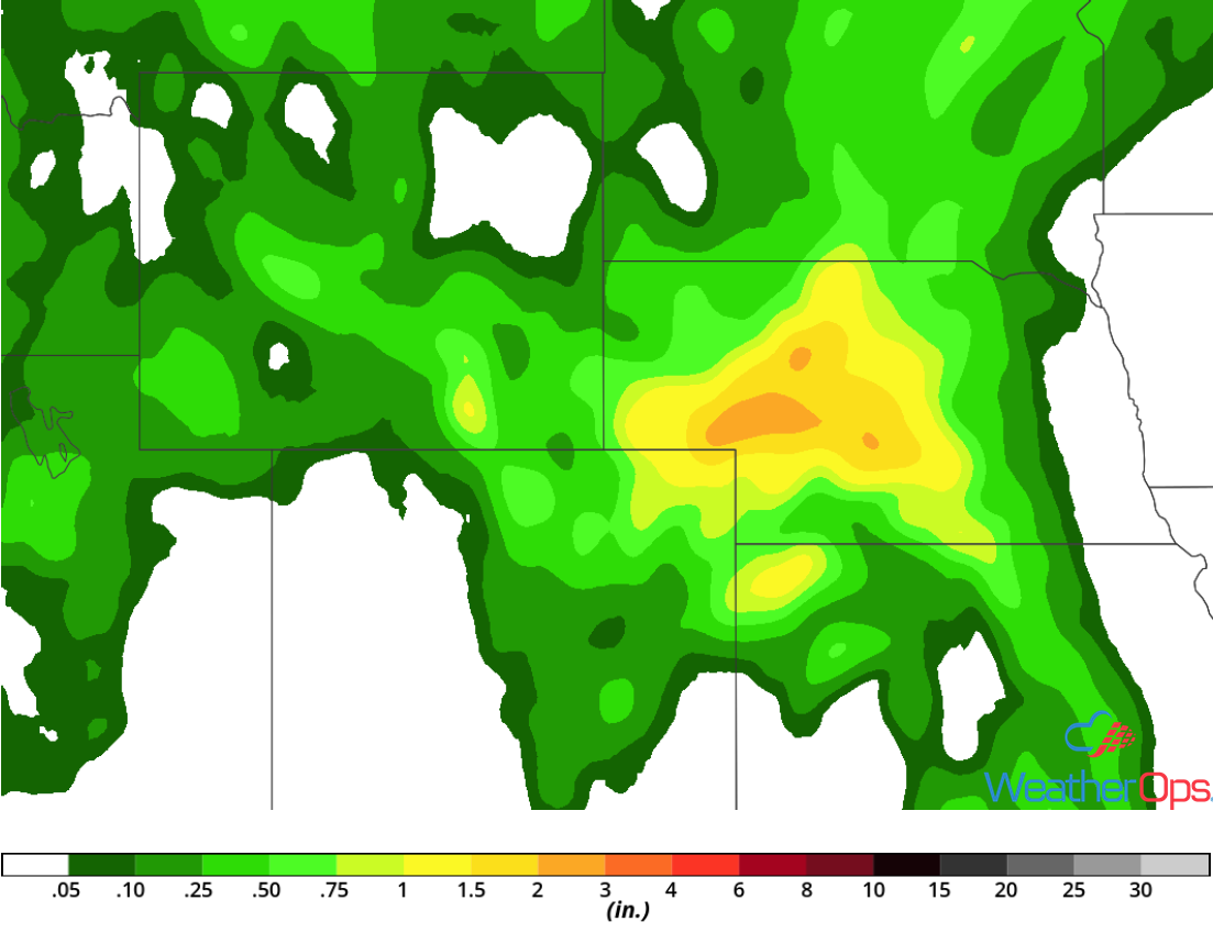
Excessive Rainfall for the Northern High Plains on Friday
A system slowly tracking eastward across the central US will bring showers and thunderstorms to portions of the Northern High Plains on Friday. Showers and thunderstorms may become widespread and lead to an excessive rain threat. Rainfall amounts of 1-3 inches with locally higher amounts in excess of 4 inches are forecast.
Major Cities in Region: Scottsbluff, NE, North Platte, NE
 Rainfall Accumulation for Friday
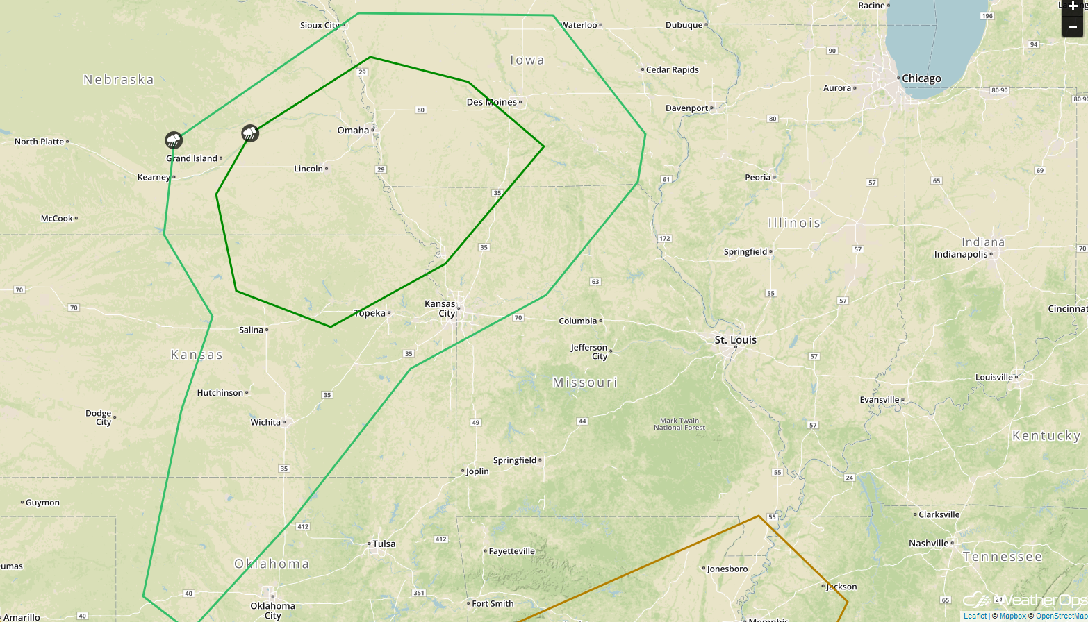
Risk for Thunderstorms Saturday from the Central Plains to the Mid Mississippi Valley
A strong upper level disturbance is forecast to track across the central US on Saturday. As it does, a strengthening area of low pressure and cold front will move into the region. Thunderstorms are forecast to develop in the vicinity of the low, as well as along and ahead of the cold front. A few storms may become severe with damaging winds and large hail the primary hazards, but an isolated tornado cannot be ruled out.
Major Cities in Region: Wichita, KS, Topeka, KS, Kansas City, MO, Omaha, NE, Des Moines, IA
 SPC Convective Outlook for Saturday
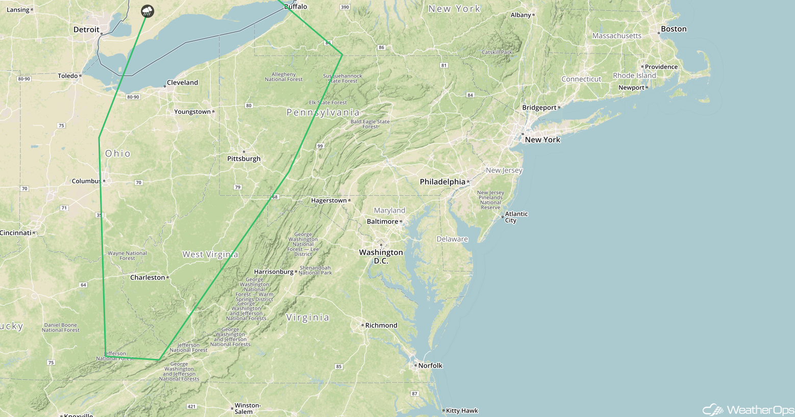
Thunderstorms for the Upper Ohio Valley on Saturday
An approaching upper level disturbance is forecast to aid in the development of thunderstorms Saturday afternoon and evening. Forcing from this disturbance combined with favorable mid level winds will lead to at least a marginal risk of strong to severe thunderstorms. Gusty winds and hail will be the primary hazards with these storms.
Major Cities in Region: Columbus, OH, Cleveland, OH, Charleston, WV, Pittsburgh, PA
 SPC Convective Outlook for Saturday
Excessive Rainfall Saturday for the Northern Plains
Heavy to excessive rainfall is expected across the Northern Plains on Saturday as an area of low pressure lifts northeastward. Rainfall totals will range 1-1.5 inches with locally higher amounts in excess of 2 inches forecast, resulting in the potential for flooding.
Major Cities in Region: Pierre, SD, Sioux Falls, SD
 Rainfall Accumulation for Saturday
A Look Ahead
Showers and thunderstorms will continue for portions of the Plains and the Upper Midwest on Sunday as the area of low pressure over the Plains continues to move northeastward. This activity will move into the Great Lakes and Ohio Valley on Monday. Thunderstorms may move into portions of the Northeast late Tuesday.
This is just a brief look at current weather hazards. We can provide you site-specific weather forecast information for the purpose of protecting your personnel and assets and to assess your weather risk. Try a 7-day demo right away and learn how timely precision weather information can enhance your bottom line.
