


by David Moran, on Jul 26, 2018 11:32:51 AM
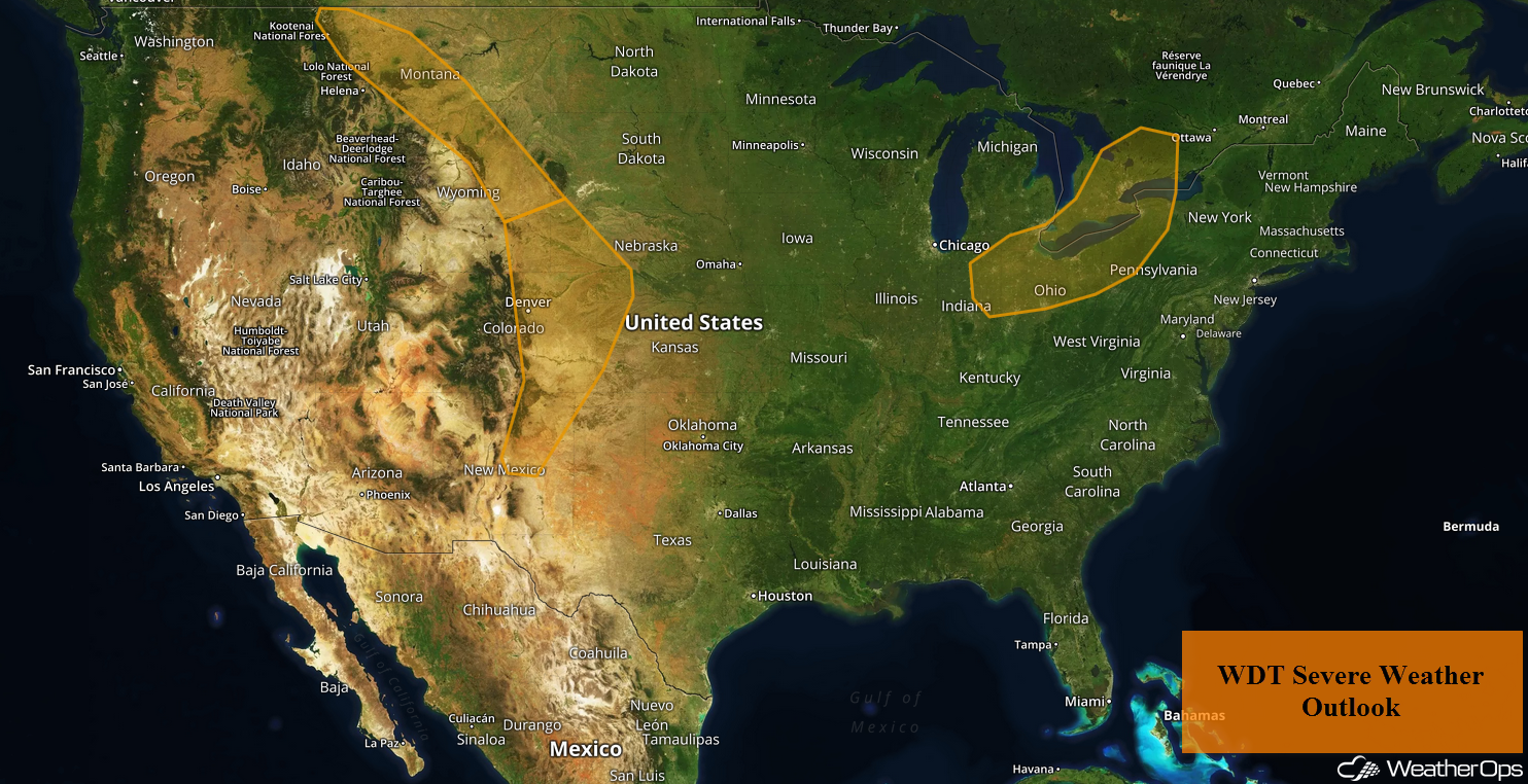
Thunderstorms may develop across the Ohio Valley on Thursday ahead of a cold front. Upslope winds will allow for a risk of thunderstorms from Montana to the Colorado Front Range through Friday. Further south, upslope flow may allow for a risk of excessive rainfall across the Central and Southern High Plains. Across Upper New England, showers may pose a risk for excessive rainfall.
- Thunderstorms for the Ohio Valley on Thursday
- Risk for Thunderstorms through Friday from Montana to the Colorado Front Range
- Excessive Rainfall for the Central and Southern High Plains Thursday
- Potential for Excessive Rainfall Thursday across Upper New England
- Thunderstorm Potential from New England to the Central Appalachians on Friday
- Excessive Rainfall Friday and Saturday from Wyoming to Kansas
- Thunderstorms for the Central Plains on Saturday
US Hazards
Thunderstorms for the Ohio Valley on Thursday
A cold front will move through the Midwest and into the Ohio Valley on Thursday. Thunderstorms will develop ahead of the front during the mid to late afternoon from Illinois into Ohio, with some storms continuing across western Pennsylvania into the overnight hours. Strong wind shear, as well as instability, along the front will support storms capable of producing severe winds and hail. An isolated tornado or two cannot be ruled out.
Major Cities in Region: Toledo, OH, Columbus, OH, Cleveland, OH
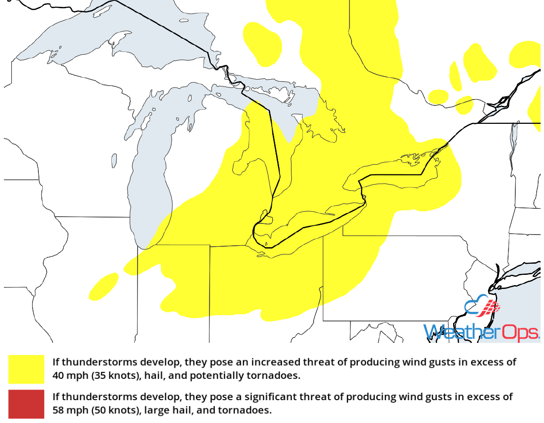
Thunderstorm Risk for Thursday
Risk for Thunderstorms through Friday from Montana to the Colorado Front Range
Upslope winds will promote convergence and instability will build across the region. This will support the development of widely scattered thunderstorms Thursday and Friday from eastern Montana southward into parts of the Colorado Front Range. Activity will likely develop during the afternoon and evening. Severe winds and large hail will be the primary hazards, but an isolated tornado or two cannot be ruled out.
Major Cities in Region: Colorado Springs, CO, Denver, CO, Cheyenne, WY
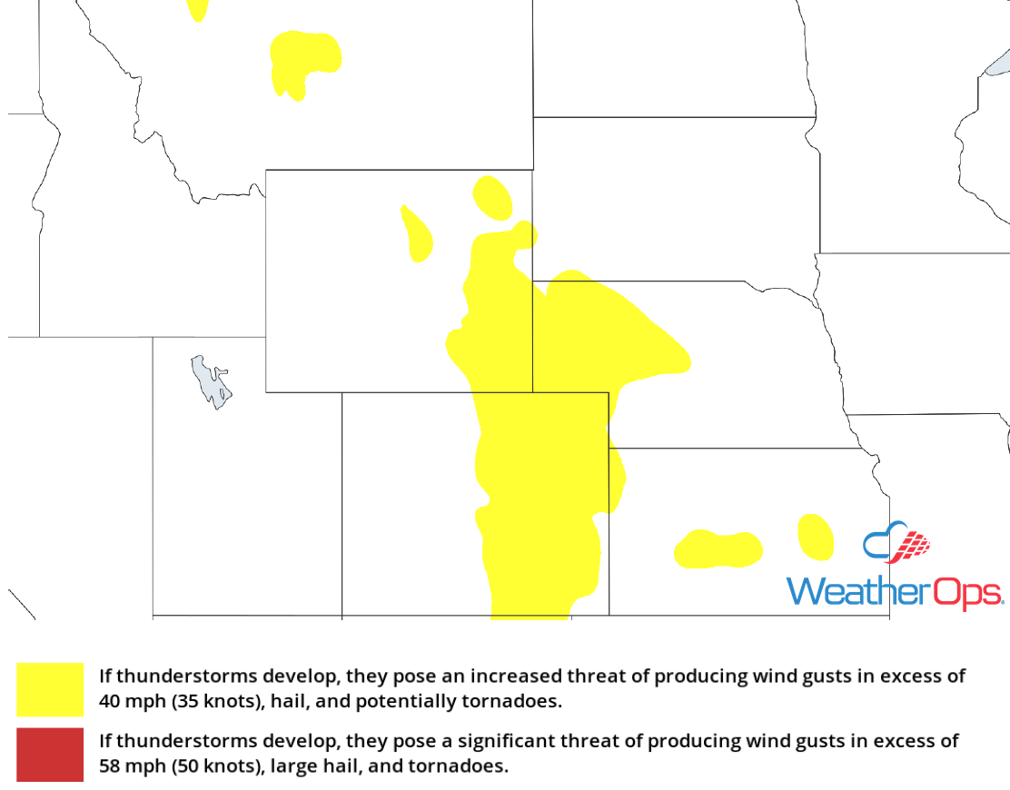
Thunderstorm Risk for Thursday
Excessive Rainfall for the Central and Southern High Plains Thursday
In addition to the thunderstorm potential described above, there will be a risk for excessive rainfall from Colorado into eastern New Mexico. Areas that receive multiple rounds of storms will pick up rainfall amounts of 1-2 inches with locally higher amounts in excess of 3 inches. This may contribute to minor flooding and runoff in some areas.
Major Cities in Region: Colorado Springs, CO, Denver, CO, Roswell, NM, Carlsbad, NM

Rainfall Accumulation for Thursday
Potential for Excessive Rainfall Thursday across Upper New England
Showers are ongoing across the Northeast this morning as an upper level low remains in place across the region. With ongoing activity and additional development this afternoon, rainfall totals of 1-2 inches are forecast through early Friday morning. This could result in minor flooding and runoff.
Major Cities in Region: Burlington, VT, Portland, ME, Augusta, ME
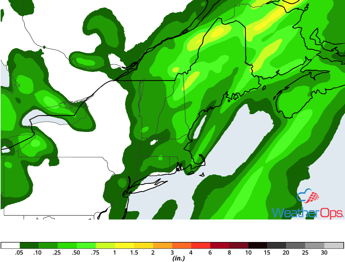
Rainfall Accumulation for Thursday
Thunderstorm Potential from New England to the Central Appalachians on Friday
The cold front that is forecast to move into the Ohio Valley on Thursday will reach the Northeast on Friday. Thunderstorms, some severe, are forecast during the afternoon and evening. Severe winds will be the primary hazard, but there will also be a risk for hail and isolated tornadoes.
Major Cities in Region: Harrisonburg, VA, Washington, DC, Baltimore, MD, Philadelphia, PA, New York, NY, Albany, NY, Burlington, VT
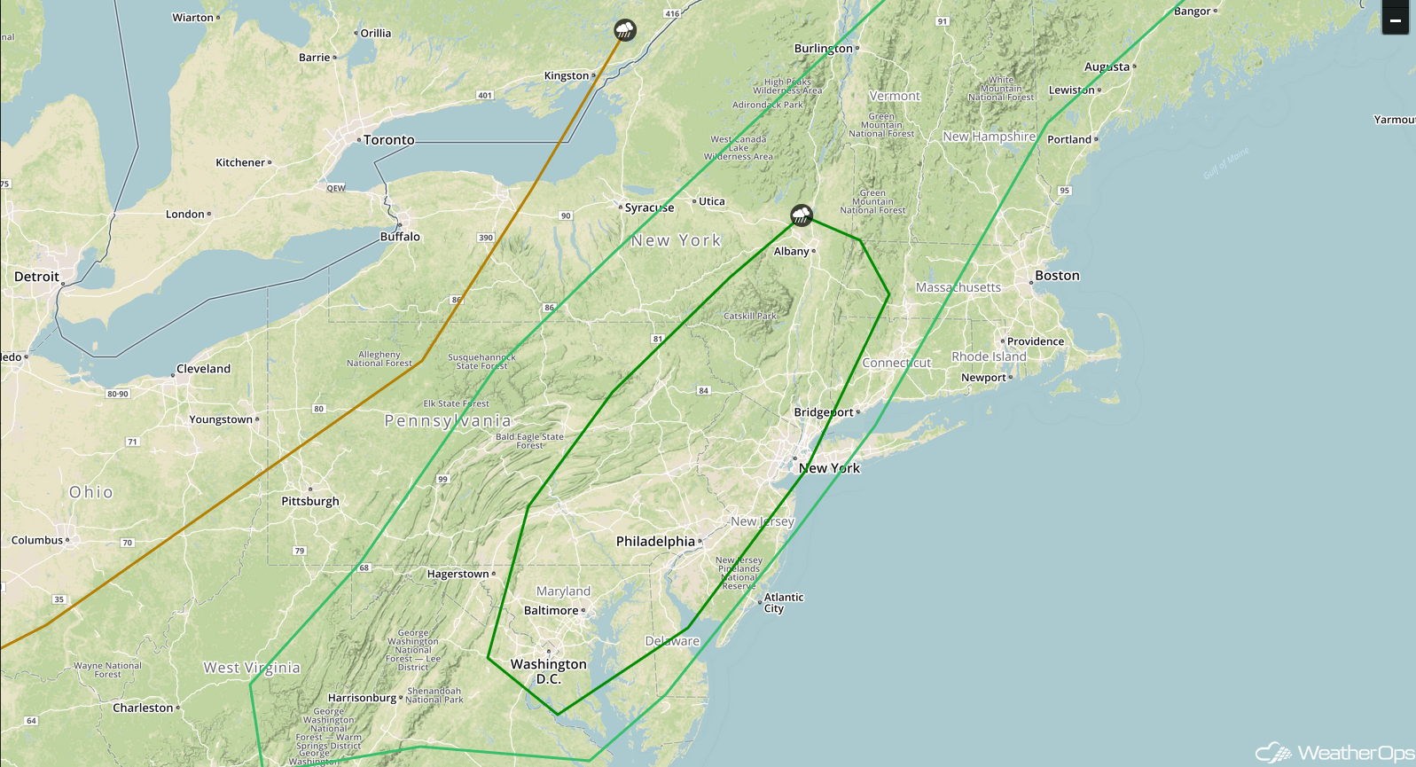
SPC Convective Outlook for Friday
Excessive Rainfall Friday and Saturday from Wyoming to Kansas
Northwesterly flow aloft and upslope surface winds will promote scattered showers and thunderstorms from Wyoming to Kansas Friday into Saturday. Rainfall accumulations of 1-2 inches with locally higher amounts in excess of 3 inches are expected, leading to a risk for minor flooding and runoff.
Major Cities in Region: Cheyenne, WY, Scottsbluff, NE, Goodland, KS
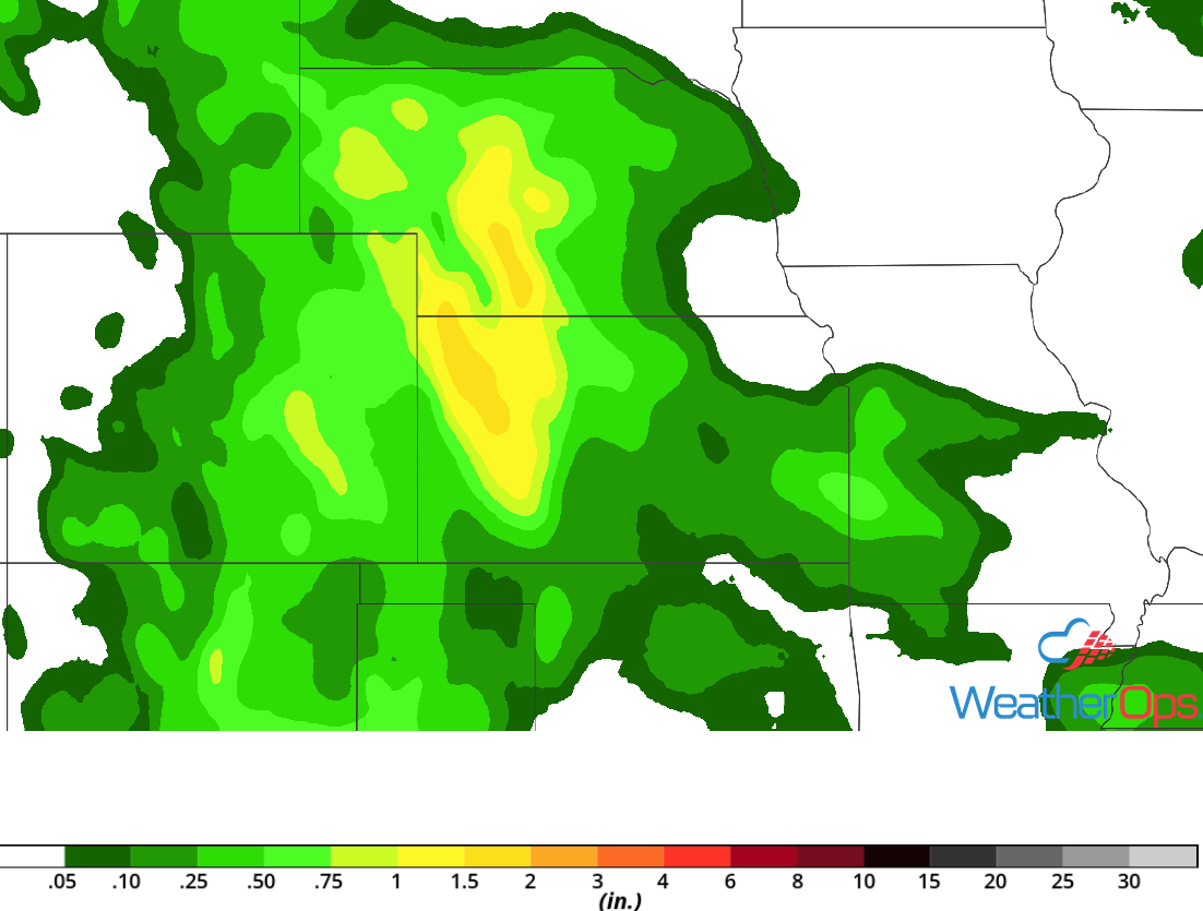
Rainfall Accumulation for Friday and Saturday
Thunderstorms for the Central Plains on Saturday
By Saturday, an area of low pressure will begin to move southward into the Central Plains. Showers and thunderstorms are forecast from Wyoming southward into Colorado and Kansas. While a significant threat is not anticipated, a few storms could become severe with damaging winds and hail the primary hazards. Activity should taper off through the evening hours with the severe threat diminishing after dark.
Major Cities in Region: Denver, CO, Cheyenne, WY, North Platte, NE, Dodge City, KS, Kearney, NE, Wichita, KS
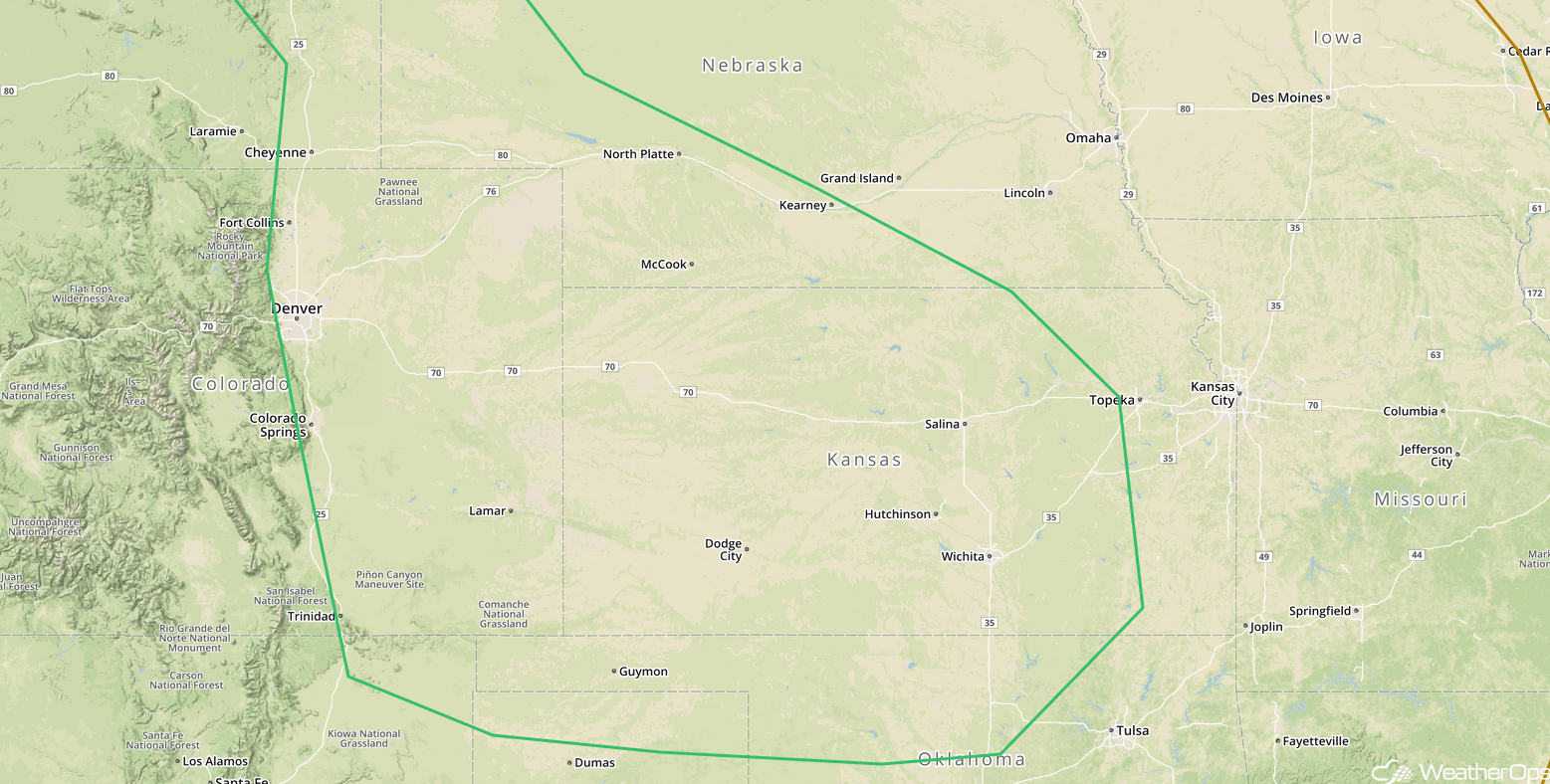
SPC Convective Outlook for Saturday
A Look Ahead
Showers and thunderstorms may develop across portions of the Plains on Sunday along a stalled front. This activity may continue and spread into the Missouri Valley on Monday. By Tuesday, an area of low pressure may develop over the eastern US, bringing a potential for thunderstorms to portions of the Ohio and Mid Mississippi Valleys. This activity will move northeastward into the Northeast and Appalachians on Wednesday.
