National Weather Summary for Thursday, July 20, 2017
by David Moran, on Jul 20, 2017 10:27:02 AM
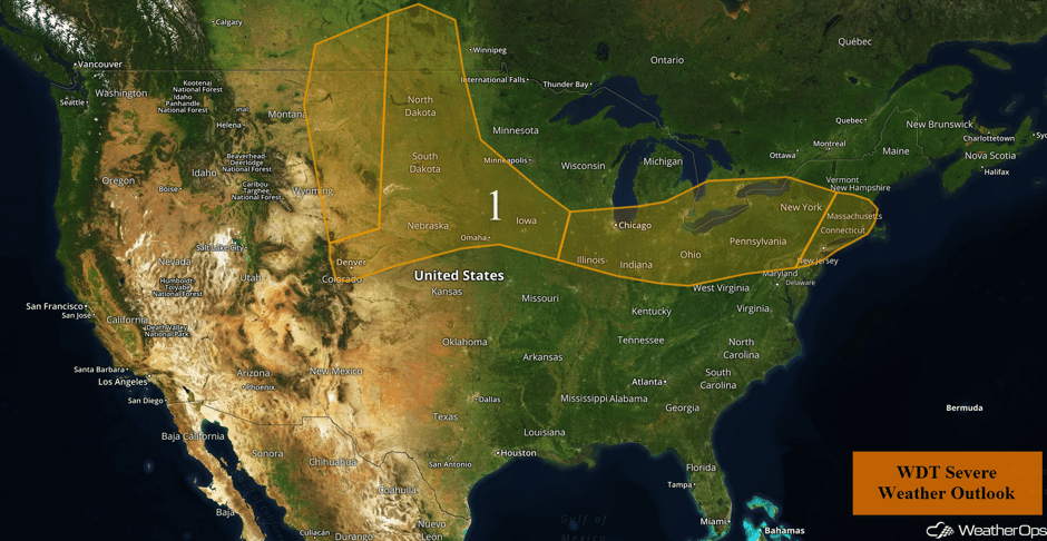
A few thunderstorms may develop over the Northern High Plains on Thursday as an area of low pressure intensifies over the region. A stalled front will be the focus for the development of thunderstorms from the Midwest into the Northeast on Thursday. Heavy to excessive rainfall will continue across the Desert Southwest through Friday, leading to the potential for flash flooding.
- Thunderstorms Thursday from the Northern High Plains to the Northeast
- Excessive Rainfall Continuing through Friday across the Southwest
- Risk for Thunderstorms from the Northern Plains into the Ohio Valley on Friday
- Strong to Severe Thunderstorms Friday across the Central High Plains
- Thunderstorms from the Northern Plains into the Ohio Valley on Saturday
 US Hazards
Thunderstorms Thursday from the Northern High Plains to the Northeast
A developing area of low pressure across central and eastern Montana will lead to the development of strong to severe thunderstorms across the Northern High Plains. To the east and south of the low and along the developing cold front, instability is forecast to build into the afternoon and evening. With any storms that develop, large hail and damaging winds will be the primary hazards.
Further east across the Northern Plains, a warm front will lift northward across the region. Thunderstorms may develop along and ahead of the front, especially into the afternoon. Initial thunderstorms will have the potential to produce gusty winds and large hail. By late evening, thunderstorms will continue to move eastward with gusty winds the primary hazard with these storms.
From the Mid Mississippi Valley into the Northeast, thunderstorms are forecast to develop during the afternoon and evening. Strong wind gusts will be the primary hazard, but there will also be a risk of large hail. A low tornado threat will exist over northern Pennsylvania and western New York.
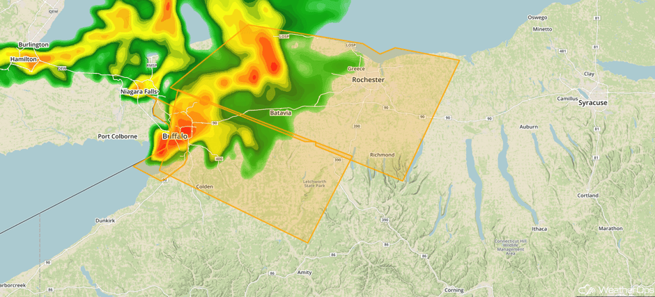
Update 12:34pm EDT: Severe thunderstorms capable of hail and damaging winds moving into western New York.
 Radar 12:34pm EDT
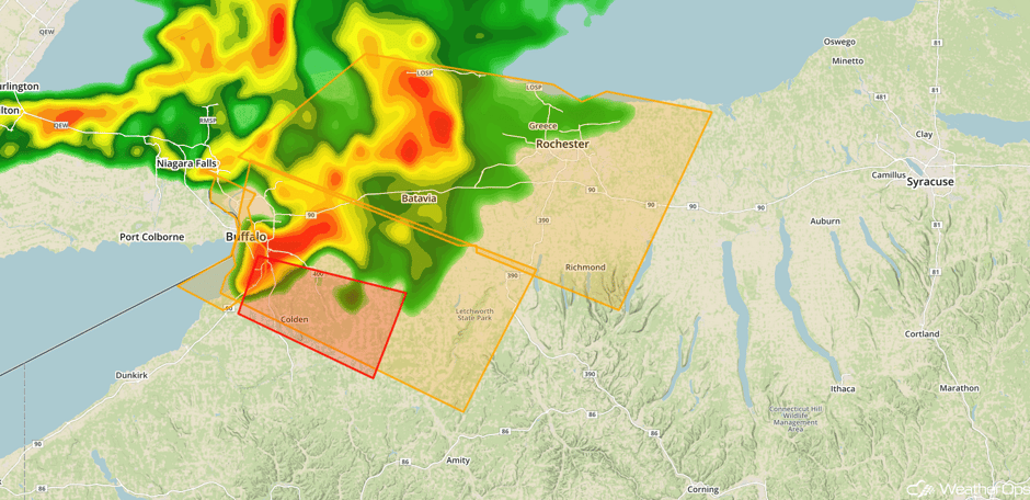
Update 12:43pm EDT: Tornado Warning south of Buffalo, NY
 Radar 12:43pm EDT
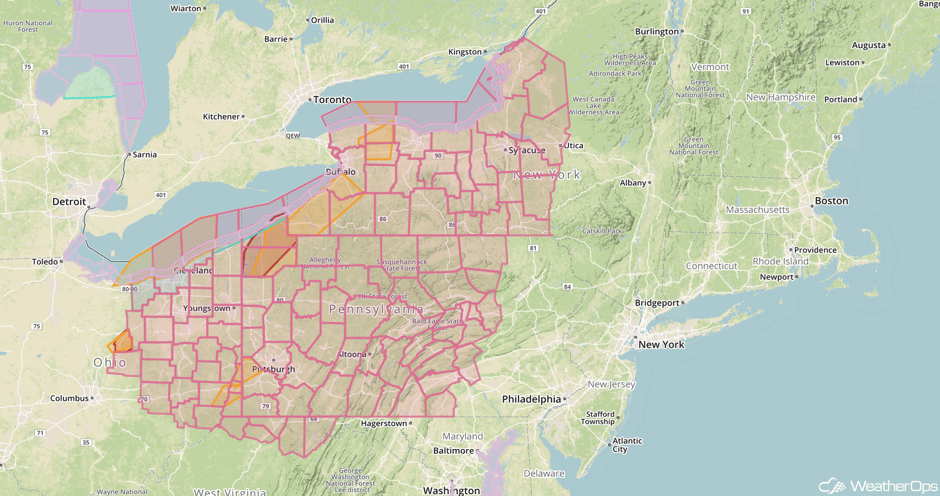
Update 1:19pm EDT: Severe Thunderstorm Watch in effect for portions of New York and Pennsylvania until 8pm EDT.
 Severe Thunderstorm Watch
Update 1:40pm EDT: Tornado Warning near Amity, NY.
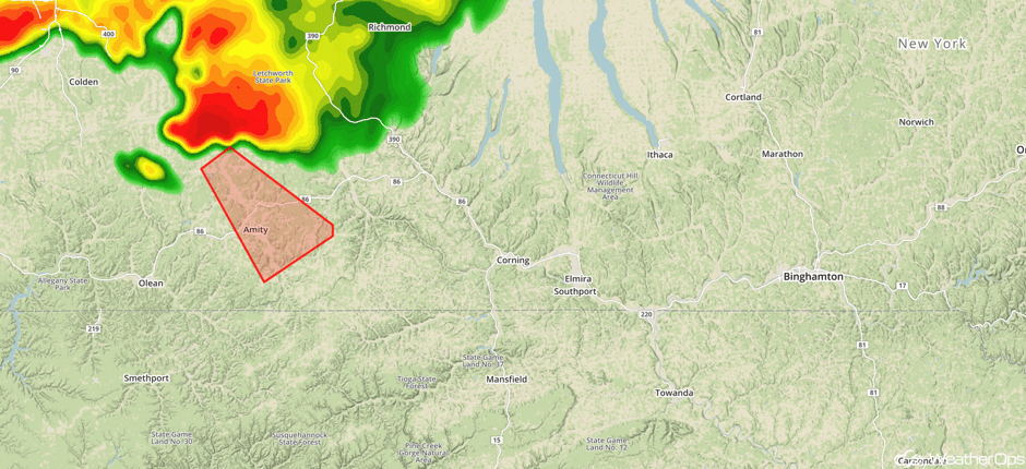 Radar 1:40pm EDT
Update 2:52pm EDT: Severe thunderstorms capable of damaging winds moving into north central Pennsylvania.
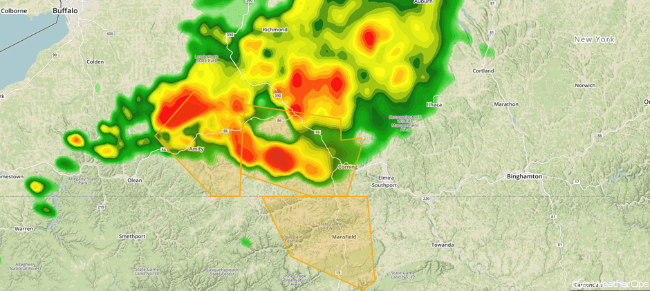 Radar 2:52pm EDT
Major Cities in Region: Denver, CO, Cheyenne, WY, North Platte, NE, Bismarck, ND, Pierre, SD, Sioux Falls, SD, Omaha, NE, Des Moines, IA, Chicago, IL, Indianapolis, IN, Columbus, OH, Cleveland, OH, Pittsburgh, PA, Rochester, NY, Philadelphia, PA, New York, NY, Boston, MA
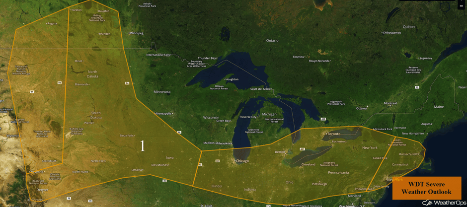 Region 1
Excessive Rainfall Continuing through Friday across the Southwest
Isolated to widely scattered showers and thunderstorms are forecast to develop across the Southwest Thursday and Friday with ample moisture available. Some of these storms will produce heavy rainfall rates (in excess of an inch per hour). Given multiple days of previous rainfall, there will be an increased risk of flash flooding.
Major Cities in Region: Phoenix, AZ, Flagstaff, AZ, Tucson, AZ
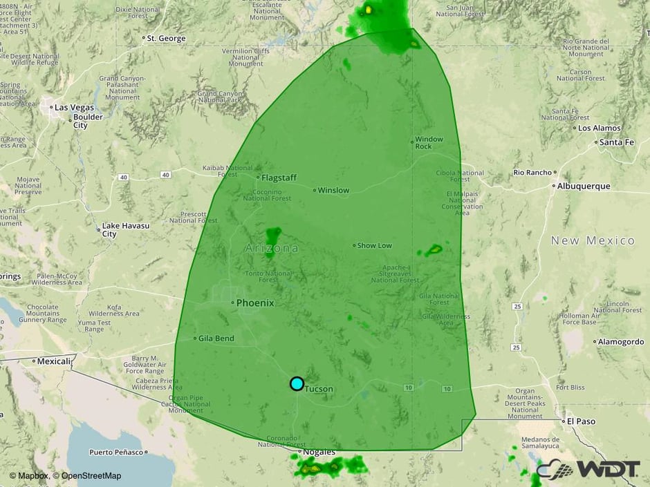 Excessive Rainfall Risk Outline for Thursday and Friday
Risk for Thunderstorms from the Northern Plains into the Ohio Valley on Friday
The severe weather threat will return to the Northern Plains and Ohio Valley as a large area of low pressure develops over the Plains. A warm front will lift into the region, creating a favorable environment for the development of thunderstorms. Showers and thunderstorms will be possible along the warm front through much of the day over the Midwest, with an increase in intensity during the afternoon and evening. Large hail and damaging winds will be the primary hazards with these storms. Additional development is forecast into the evening and overnight hours with damaging winds the primary hazard.
Flash flooding will also be likely over the Upper Midwest along the warm front given the previous days of heavy rainfall. Additional rainfall will cause an elevated risk of flash flooding.
Major Cities in Region: Sioux Falls, SD, Minneapolis, MN, Milwaukee, WI, Chicago, IL, Detroit, MI
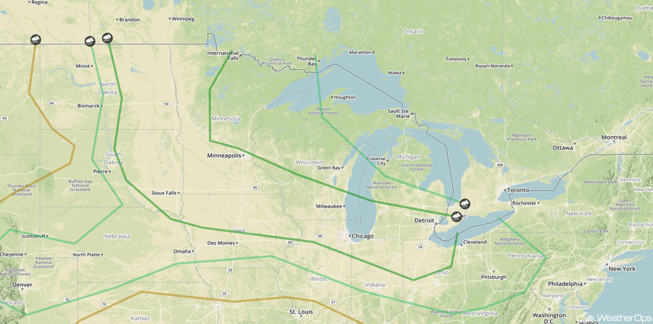 SPC Convective Outlook for Friday
Strong to Severe Thunderstorms Friday across the Central High Plains
There will be a chance for isolated to scattered thunderstorms over the high terrain into the High Plains on Friday as daytime heating increases. Storms over the Rockies may move eastward during the afternoon with large hail being the primary hazard.
Major Cities in Region: Scottsbluff, NE, Minot, ND, Bismarck, ND
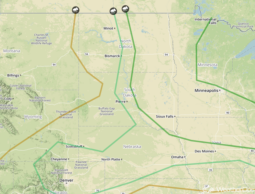 SPC Convective Outlook for Friday
Thunderstorms from the Northern Plains into the Ohio Valley on Saturday
On Saturday, the area of low pressure over the Plains will become more progressive and shift into the Midwest as an upper level trough moves through the Northern Plains. Over the Great Lakes into the Ohio Valley, showers and thunderstorms are forecast for much of the day as a warm front lifts into the region. By the afternoon, some of this activity may become strong to severe with hail and damaging winds the primary hazards. Over the Northern Plains, the severe weather potential will ramp up during the afternoon hours as another area of low pressure develops over northern Minnesota. Primary hazards with any storms that become severe will be large hail, damaging winds, and isolated tornadoes.
Major Cities in Region: Minneapolis, MN, Green Bay, WI, Milwaukee, WI, Chicago, IL, Detroit, MI, Cleveland, OH, Pittsburgh, PA, Washington, DC, Philadelphia, PA
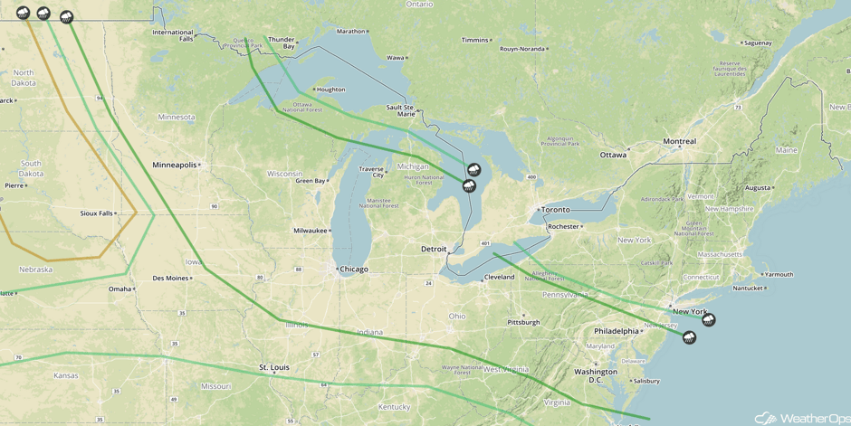 SPC Convective Outlook for Saturday
A Look Ahead
A few thunderstorms may develop over the Ohio Valley on Sunday as a cold front moves into the region. Strong winds and hail will be the primary hazards before the storms diminish during the evening.
This is just a brief look at current weather hazards. We can provide you site-specific weather forecast information for the purpose of protecting your personnel and assets and to assess your weather risk. Try a 7-day demo right away and learn how timely precision weather information can enhance your bottom line.


