


by David Moran, on Feb 28, 2019 10:27:42 AM
Snow will continue from the western US into the Northern Rockies through Friday as an area of low pressure moves across the region. Freezing rain and snow are expected to continue across the Missouri River Valley. Fog will continue along the Texas and Louisiana coasts through Saturday morning.
- Snow from the Western US into the Northern Rockies on Friday
- Freezing Rain and Snow Thursday across the Missouri River Valley
- Fog along the Texas and Louisiana Coasts through Saturday Morning
- Snow Friday for the Northern Plains and Upper Midwest
- Potential for Snow from the Rockies into the Central Plains on Saturday
- Thunderstorms Saturday for the Arklatex Region
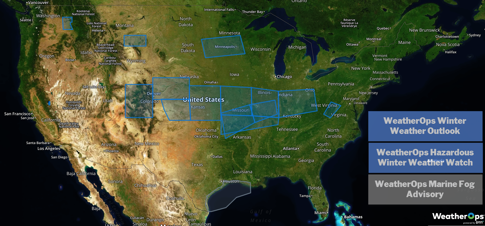
US Hazards
Snow from the Western US into the Northern Rockies on Friday
An area of low pressure will move along a stalled frontal boundary located across the Intermountain West, bringing the potential for snowfall through Friday. Another round of light snow may develop Friday into Saturday as a cold front tracks southward across the region. Snowfall totals will range 2-4 inches in the lower elevations and 4-8 inches in the higher elevations.
Major Cities in Region: Spokane, WA, Missoula, MT, Butte, MT, Idaho Falls, ID, Cody, WY
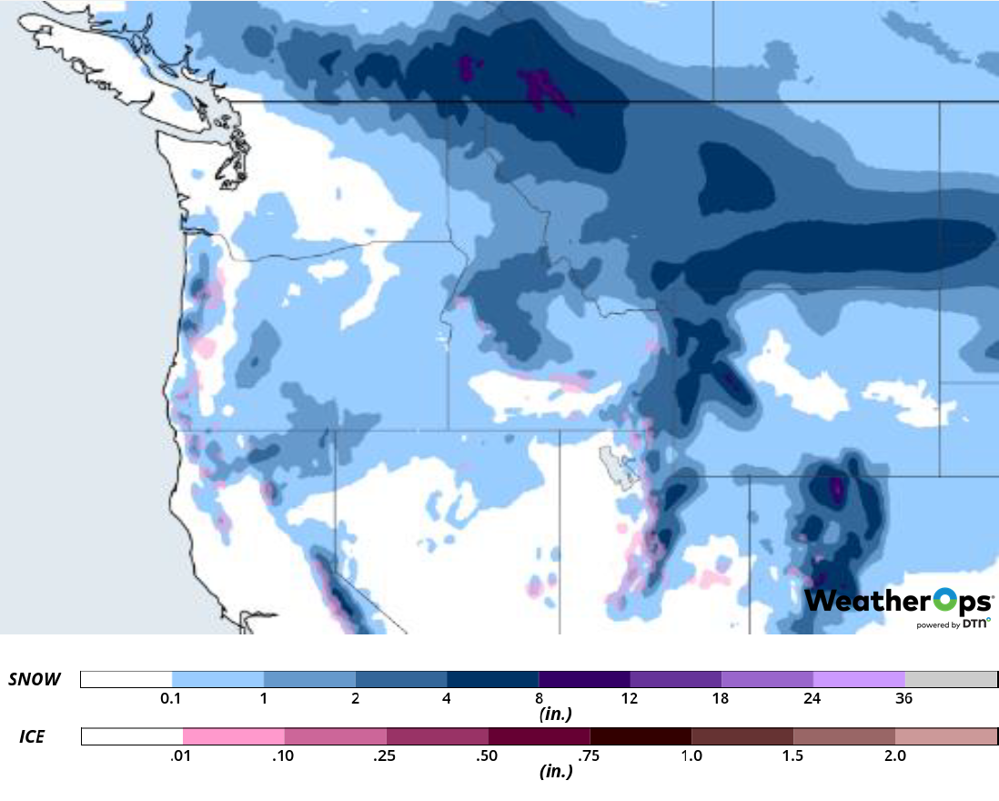
Snowfall Accumulation through Friday
Freezing Rain and Snow Thursday across the Missouri River Valley
Light wintry precipitation has developed across portions of Missouri and Illinois and is forecast to persist through the afternoon and early evening. Freezing rain and snow will continue to create hazardous travel conditions. Ice accumulations will range from a glaze to 0.10 inch with locally higher amounts in excess of 0.25 inch. Sleet accumulations of 1-2 inches are expected. Snow accumulations of 1-2 inches with locally higher amounts in excess of 3 inches are forecast.
Major Cities in Region: Columbia, MO, St. Louis, MO
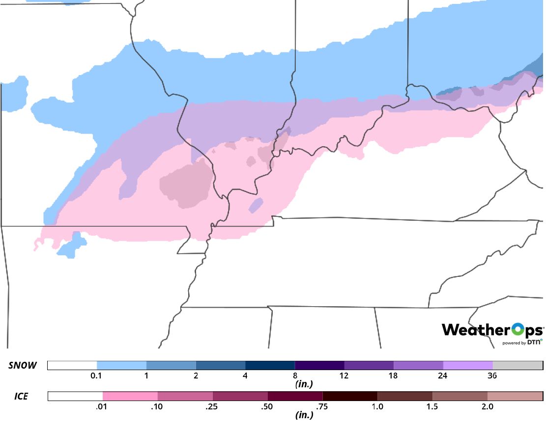
Snow and Ice Accumulation for Thursday
Fog along the Texas and Louisiana Coasts through Saturday Morning
Moisture and light winds will produce fog along the Texas and Louisiana coasts through Saturday morning. Fog will be most dense during the overnight and morning hours with some improvement during the afternoon. Visibilities may be less than a mile at times.
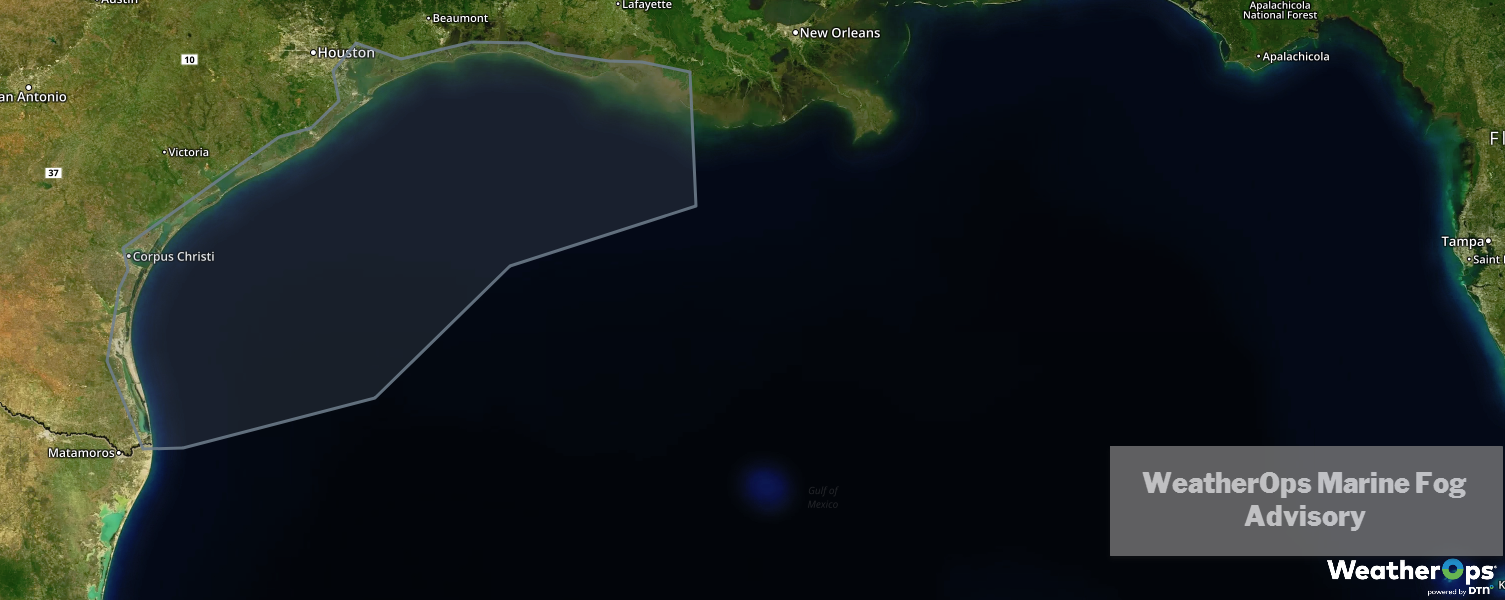
WeatherOps Marine Fog Advisory
Snow Friday for the Northern Plains and Upper Midwest
A strong arctic cold front is forecast to track southward across the Northern Plains and Upper Midwest on Friday, bringing the potential for light to moderate snowfall across the region. Snowfall accumulations of 2-5 inches are expected from central South Dakota eastward into Minnesota and Wisconsin.
Major Cities in Region: Pierre, SD, Grand Forks, ND, Sioux Falls, SD, Minneapolis, MN, Wausau, WI, Green Bay, WI
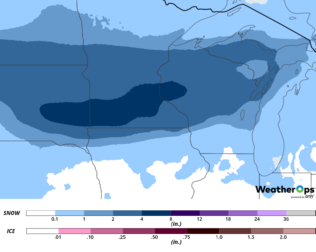
Snow Accumulation for Friday
Potential for Snow from the Rockies into the Central Plains on Saturday
An area of low pressure is forecast to develop in the lee of the Rockies and track eastward across the Southern Plains on Saturday. As this occurs, warm moist air is forecast to move northward ahead of the cold front associated with the low. This will result in widespread freezing rain and snow. Snow accumulations will range 3-6 inches with locally higher amounts in excess of 10 inches. In addition, the low will be intensifying over the Southern Plains, resulting in gusty winds Saturday night into Sunday. This will result in the potential for blowing and drifting snow. Wind chills will be as low as -20°F in some places.
Major Cities in Region: Cheyenne, WY, North Platte, NE, Omaha, NE
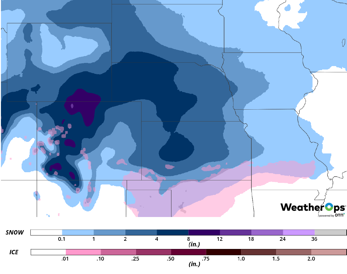
Snow Accumulation for Saturday
Thunderstorms Saturday for the Arklatex Region
As an area of low pressure develops in the Southern Plains and quickly tracks eastward toward the Tennessee Valley Saturday afternoon and evening, southerly flow will bring moist air northward. In addition, wind shear will increase across the region during the late afternoon and early evening. With these conditions in place, thunderstorms are expected to develop, some of which may become strong to severe. Damaging winds and large hail will be the primary hazards with the strongest storms.
Major Cities in Region: Texarkana, AR, El Dorado, AR, Little Rock, AR
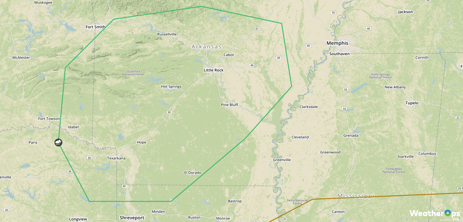
SPC Convective Outlook for Saturday
A Look Ahead
Snow will extend from the Plains into the Mid Atlantic on Sunday as a cold front continues to move southward. By Monday, the snow will extend from the Appalachians into the Northeast. Thunderstorms may develop across the Southeast. Rain and snow are forecast across portions of California on Tuesday as an area of low pressure moves onshore. Snow will spread into the Rockies on Wednesday.
Note: The National Weather Summary has been discontinued. This will be the last forecast.
