by David Moran, on Dec 20, 2018 10:45:15 AM
Thunderstorms will continue across Florida on Thursday ahead of a cold front. As this front moves eastward, thunderstorms may develop across the Coastal Carolinas and Southeast Virginia. These thunderstorms will have the potential to produce excessive rainfall. Excessive rainfall is forecast from northeast Georgia into Southern New England. Elevated winds and seas will continue across the Gulf of Mexico through Saturday morning as a cold front moves eastward.
- Thunderstorms across Florida on Thursday
- Potential for Thunderstorms Thursday across the Coastal Carolinas and Southeast Virginia
- Excessive Rainfall from Northeast Georgia into Southern New England Thursday
- Risk for Excessive Rainfall Thursday from Georgia into the Coastal Carolinas
- Elevated Winds and Seas across the Gulf of Mexico through Saturday Morning
- Snow from the Appalachians Friday and Saturday into the Northeast
- Excessive Rainfall across New England Friday
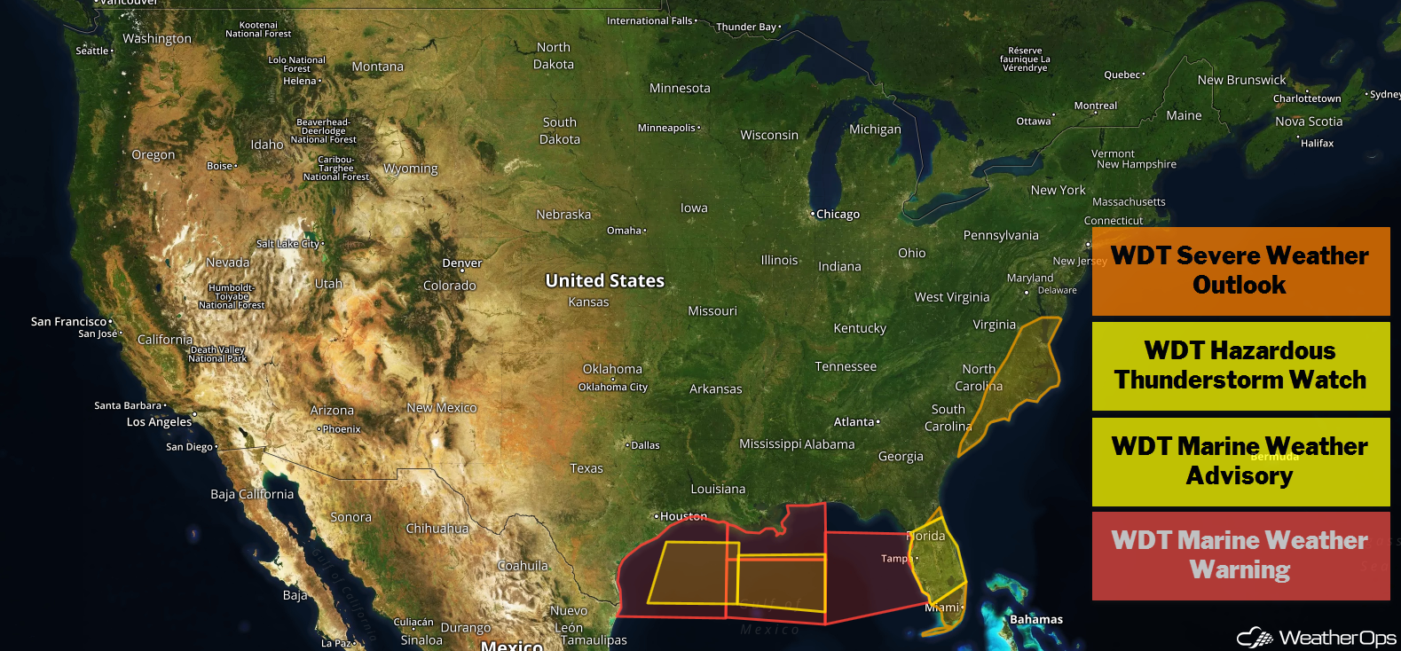
US Hazards
Thunderstorms across Florida on Thursday
A strong upper level trough will be moving over the Gulf of Mexico today, and an associated surface low has developed in the northern Gulf along a cold front. As the surface low intensifies, the front will move eastward. Strong to severe thunderstorms have been occurring over the Gulf along and ahead of the front and are expected to move across the Florida Peninsula today. Storm intensity should be the greatest during the afternoon. Damaging winds will be the primary hazard, but isolated tornadoes cannot be ruled out.
Major Cities in Region: Tampa, FL, Orlando, FL, Jacksonville, FL
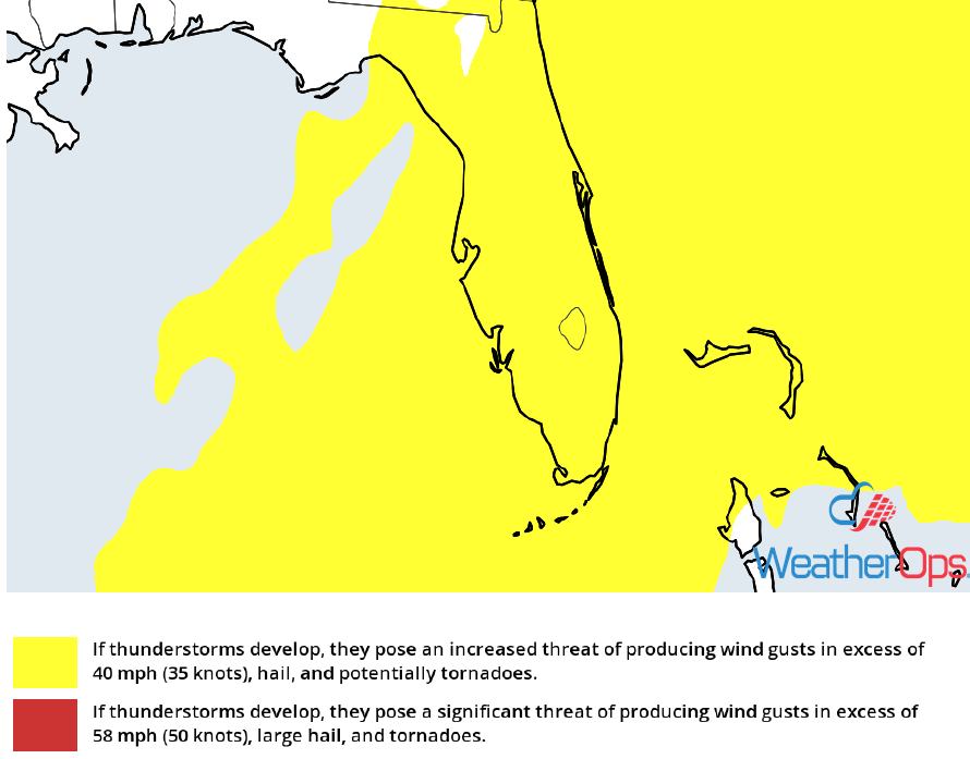
Thunderstorm Risk for Thursday
Potential for Thunderstorms Thursday across the Coastal Carolinas and Southeast Virginia
The surface low described above will move northward, and the associated cold front will move eastward. Strong to severe thunderstorms are expected along and ahead of the front. These storms will develop during the afternoon and continue into the evening. Large hail, damaging winds, and tornadoes will all be potential hazards with these storms.
Major Cities in Region: Charleston, SC, Myrtle Beach, SC, Wilmington, NC, Norfolk, VA
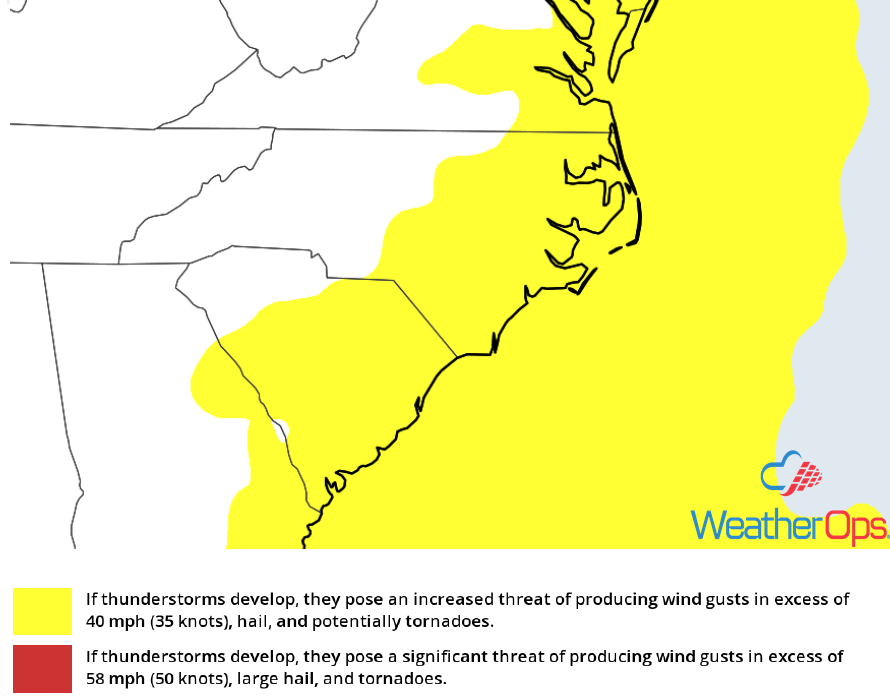
Thunderstorm Risk for Thursday
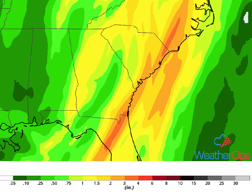
Excessive Rainfall from Northeast Georgia into Southern New England Thursday
The area of low pressure described above will continue to move north-northeastward throughout the day. Upslope flow along and to the east of the path could enhance rainfall along the eastern slopes of the Appalachians. As the low moves northward, widespread rainfall is expected to move into southern New England as moist air is being pulled northward. Rainfall amounts of 1-2 inches with locally higher amounts in excess of 3 inches are forecast through tonight.
Major Cities in Region: Charleston, SC, Myrtle Beach, SC, Wilmington, NC, Norfolk, VA, Baltimore, MD
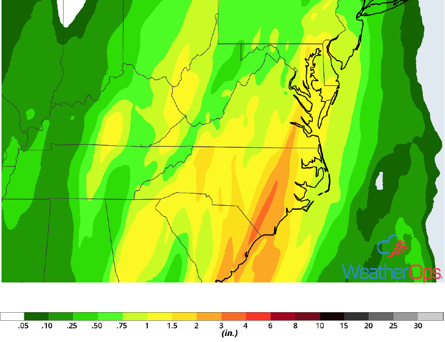
Rainfall Accumulation for Thursday
An upper level trough will be moving into the eastern US on Thursday and will extend from Canada to the Gulf of Mexico. At the surface, the area of low pressure described above will move northeastward, bringing the potential for heavy rain and thunderstorms. Rainfall totals of 1-4 inches with locally higher amounts in excess of 5 inches are expected.
Major Cities in Region: Jacksonville, FL, Charleston, SC, Myrtle Beach, SC, Wilmington, NC
Rainfall Accumulation for Thursday
Elevated Winds and Seas across the Gulf of Mexico through Saturday Morning
Elevated winds and seas will continue across the Gulf of Mexico through Saturday morning behind a cold front. Winds will be west-northwesterly to north-northwesterly at 30-40 knots with gusts in excess of 50 knots. Seas will be 7-14 feet near the shore and 15-23 feet in the deeper waters. Further east, seas will be 7-10 feet building to 10-15 feet. In addition, thunderstorms will continue through early Thursday evening with wind gusts in excess of 45 knots, waterspouts, and frequent lightning being potential hazards.
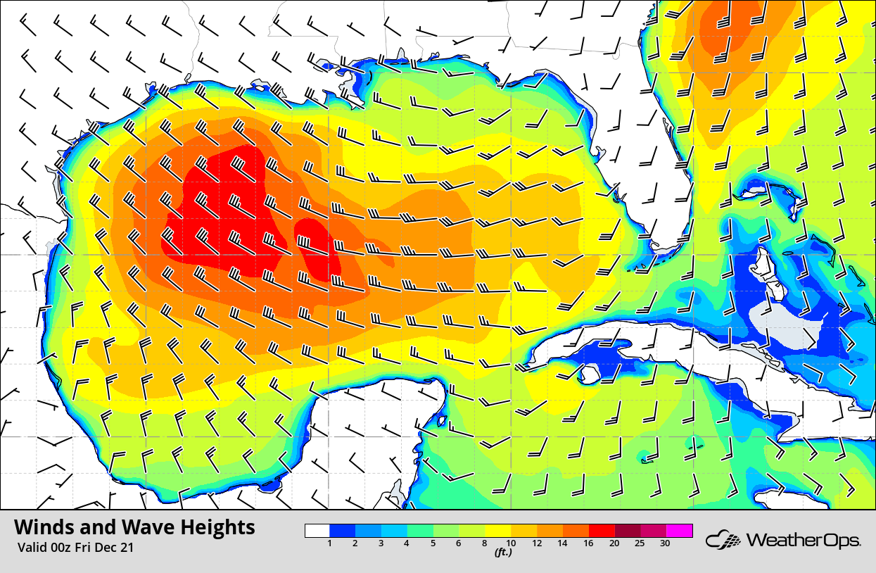
Winds and Wave Heights 6pm CST Thursday
Snow from the Appalachians Friday and Saturday into the Northeast
A strong area of low pressure moving northward along the Appalachians will move into the eastern Great Lakes tomorrow. Snow accumulations of 2-4 inches are expected across the higher elevations of the Appalachians Friday night into Saturday. However, snow is more likely further north where temperature profiles are more conducive for frozen precipitation.
Major Cities in Region: Knoxville, TN, Pittsburgh, PA, Buffalo, NY
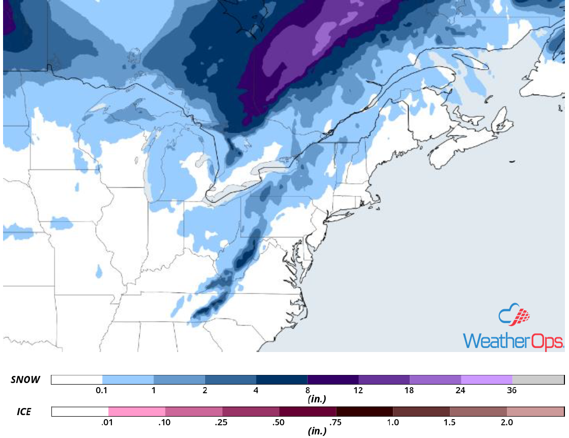
Snow Accumulation for Friday and Saturday
Excessive Rainfall across New England Friday
An area of low pressure will be moving into the Great Lakes on Friday, with moist air moving over New England to the east of the low. A strong upper level trough will be moving over the eastern US, bringing widespread rainfall to New England. Rainfall amounts will range 1-3 inches with locally higher amounts in excess of 4 inches, especially in areas receiving multiple rounds of showers and thunderstorms.
Major Cities in Region: New York, NY, Boston, MA, Augusta, ME, Bangor, ME
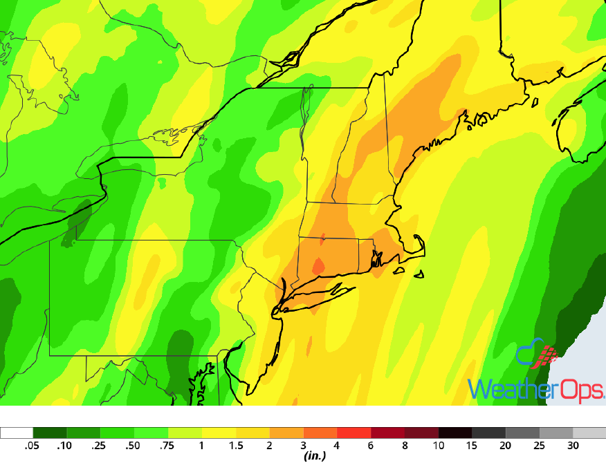
Rainfall Accumulation for Friday
A Look Ahead
Snow is forecast across portions of the Pacific Northwest and Northern Rockies on Sunday as an upper level system moves across the region. By Christmas Eve, snow will move into the Central Rockies. Going into Christmas, snow is expected from the Sierra Nevadas into the Central Rockies. An area of low pressure will develop across the Plains on Wednesday, bringing a potential for rain to the Central and Southern Plains and snow to the Northern Plains and Midwest.