


by David Moran, on Aug 9, 2018 11:06:37 AM
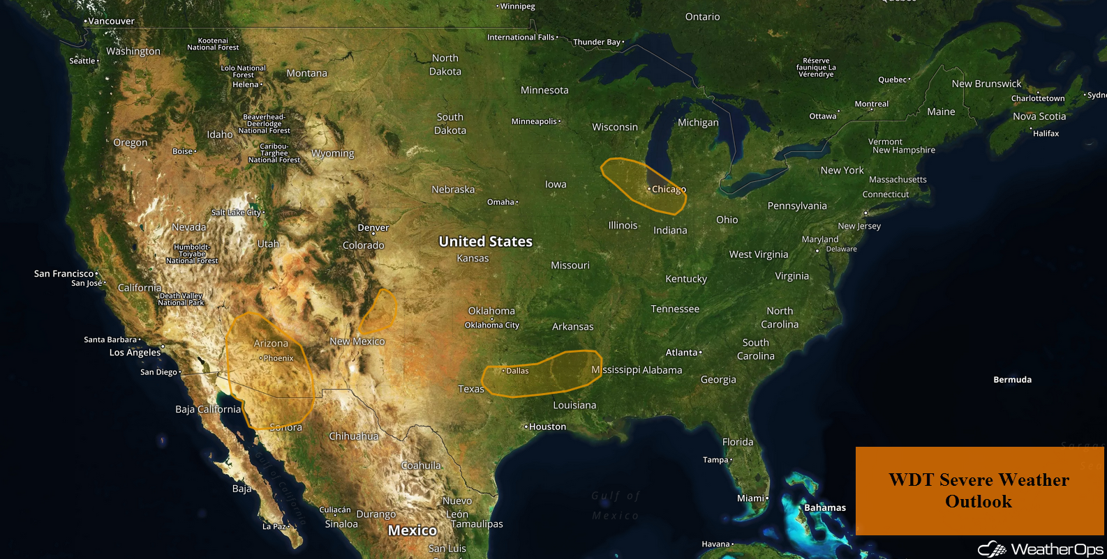
Thunderstorms are forecast to develop across northeastern New Mexico on Thursday as a result of daytime heating. Plentiful moisture and daytime heating will allow for the development of thunderstorms across portions of Arizona. These thunderstorms will pose a risk for excessive rainfall from Arizona into west Texas through Friday. A cold front moving across the Midwest will be the focus for thunderstorm development. Thunderstorms may develop across the Arklatex region along a stalled front. This front may allow for a potential for excessive rainfall from the Southern Plains into the Lower Mississippi Valley.
- Potential for Thunderstorms Thursday across Northeastern New Mexico
- Thunderstorms across Arizona on Thursday
- Excessive Rainfall through Friday from Arizona into West Texas
- Risk for Thunderstorms across the Midwest on Thursday
- Thunderstorm Potential Thursday for the Arklatex Region
- Potential for Excessive Rainfall from the Southern Plains into the Lower Mississippi Valley on Thursday
- Tropical Update
US Hazards
Potential for Thunderstorms Thursday across Northeastern New Mexico
Late afternoon and evening shower and thunderstorm activity is forecast across portions of northeast New Mexico. Storms will develop across the higher terrain; severe winds will be the primary hazard. Storms may persist after dark, but the overall severe risk will decrease.
Major Cities in Region: Las Vegas, NM, Santa Rosa, NM, Raton, NM
Thunderstorm Risk for Thursday
Thunderstorms across Arizona on Thursday
Plentiful moisture over the Southwest will contribute to a severe thunderstorm risk this evening. With this moisture in place and daytime heating, instability will increase. Outflow boundaries left behind from yesterday's activity will be the focus for thunderstorm development. Strong winds and hail will be the primary hazards, but frequent lightning and heavy rain will also be likely.
Major Cities in Region: Flagstaff. AZ, Phoenix, AZ, Tucson, AZ
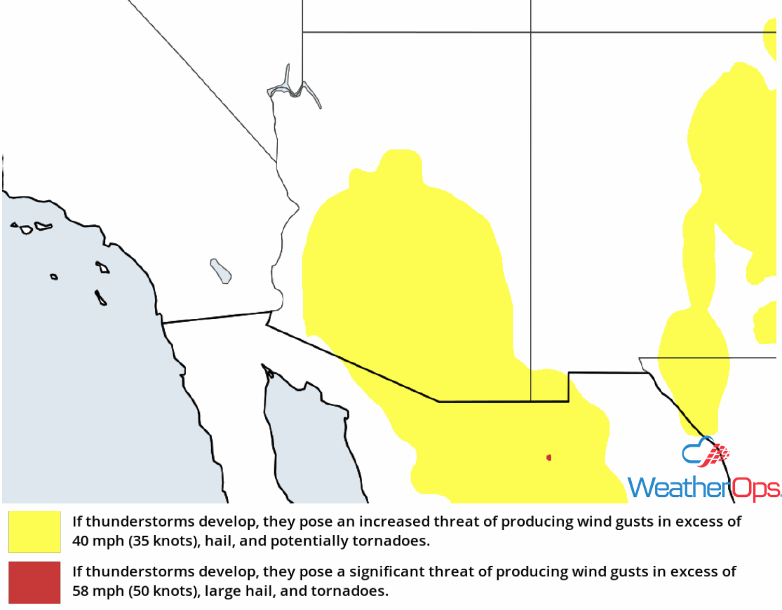
Thunderstorm Risk for Thursday
Excessive Rainfall through Friday from Arizona into West Texas
Monsoonal rains are expected to continue from Arizona into West Texas through Friday. With rich monsoonal moisture in place, strong to severe thunderstorms are expected to develop. These storms will have the potential to produce rainfall amounts ranging 1-2 inches with locally higher amounts in excess of 3 inches. Given rainfall from the last few days, there will be a risk for flooding and flash flooding.
Major Cities in Region: Phoenix, AZ, Tucson, AZ, Truth or Consequences, NM, Roswell, NM, Lubbock, TX
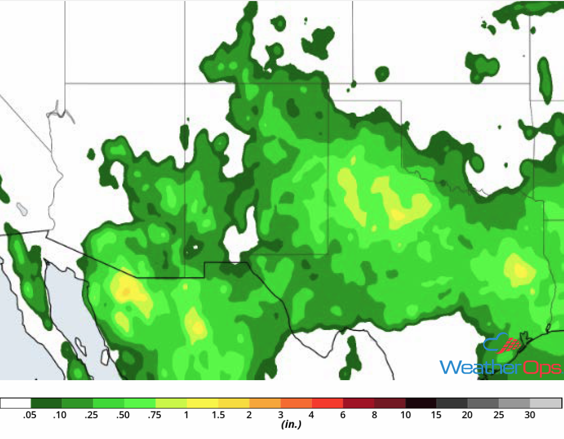
Rainfall Accumulation through Friday
Risk for Thunderstorms across the Midwest on Thursday
A cold front is forecast to track southward across portions of the Midwest throughout the day. Ahead of the front, instability will develop due to increased moisture and daytime heating. This will allow for the development of strong to severe thunderstorms. Storms will initially develop as clusters, but will evolve into linear segments as the cold front advances. Strong winds and large hail will be the primary hazards, but frequent lightning and heavy rainfall are also likely.
Major Cities in Region: Cedar Rapids, IA, Chicago, IL, Detroit, MI
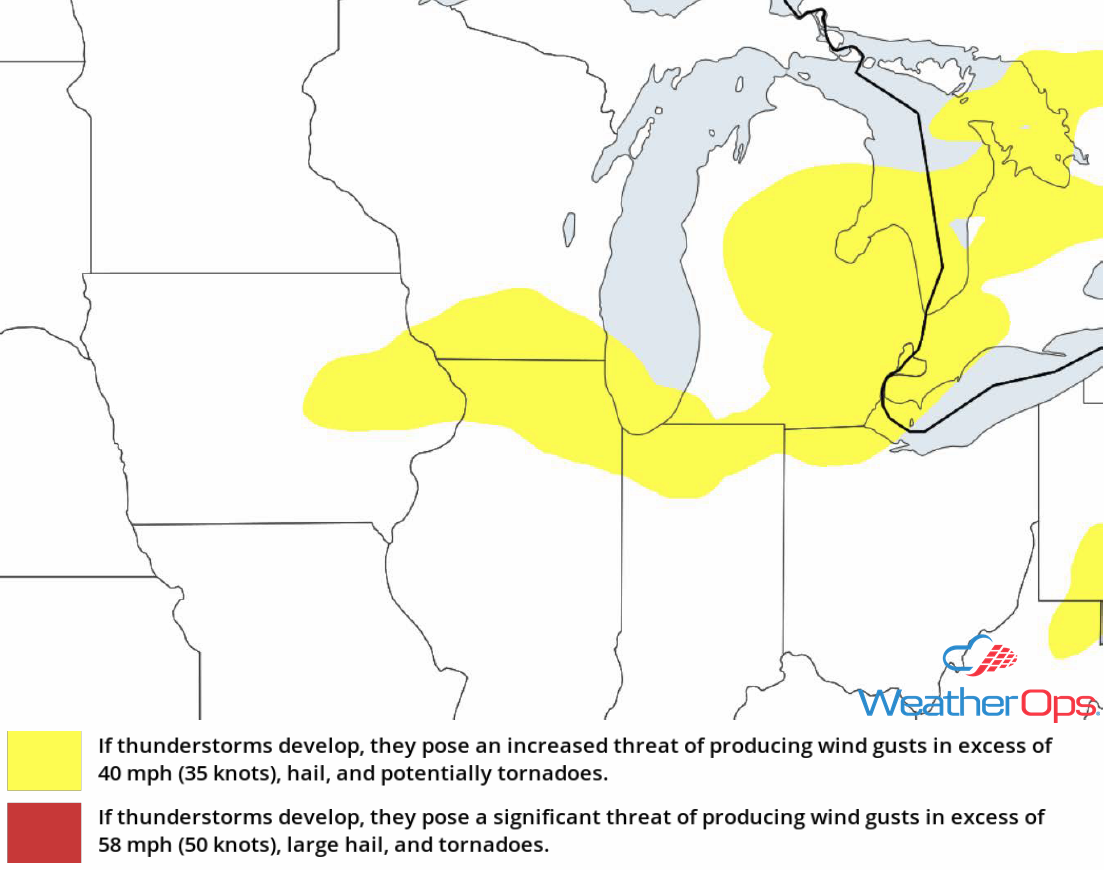
Thunderstorm Risk for Thursday
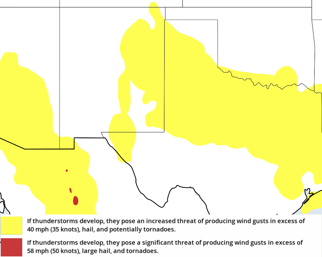
Thunderstorm Potential Thursday for the Arklatex Region
A stalled front will remain in place across the Arklatex throughout the day today. Rich Gulf moisture and daytime heating will allow instability to build. With a front providing lift and an upper level trough passing through the region, strong to severe thunderstorms are forecast to develop. Strong winds and large hail will be the primary hazards, but there will also be a risk for frequent lightning and heavy rainfall.
Major Cities in Region: Texarkana, AR, Shreveport, LA
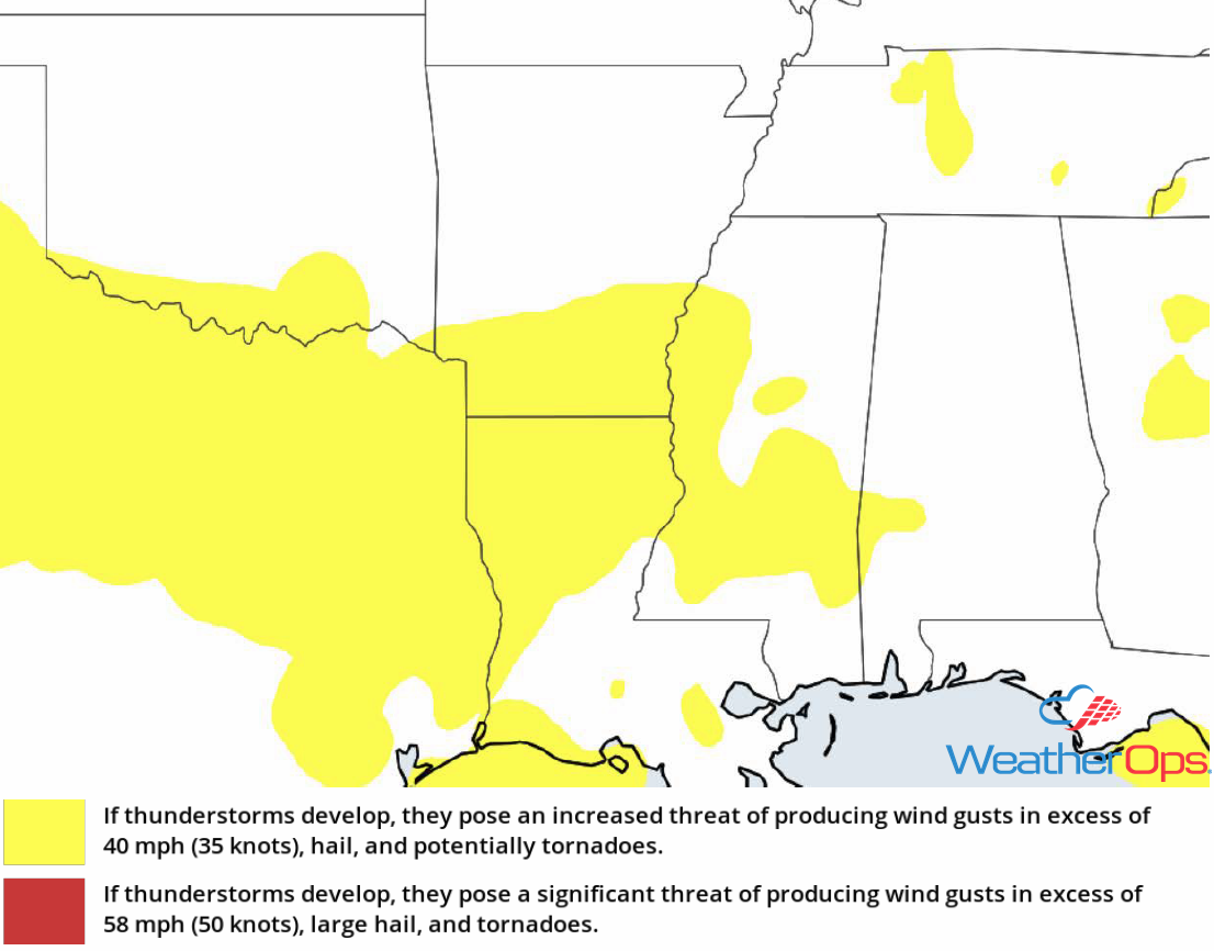
Thunderstorm Risk for Thursday
Potential for Excessive Rainfall from the Southern Plains into the Lower Mississippi Valley on Thursday
In addition to the thunderstorm risk described above, there will be a risk for excessive rainfall. Rainfall accumulations of 1.00-1.50 inches are forecast with locally higher amounts in excess of 3 inches. This will contribute to a potential for flooding and flash flooding.
Major Cities in Region: Little Rock, AR, Jackson, TN
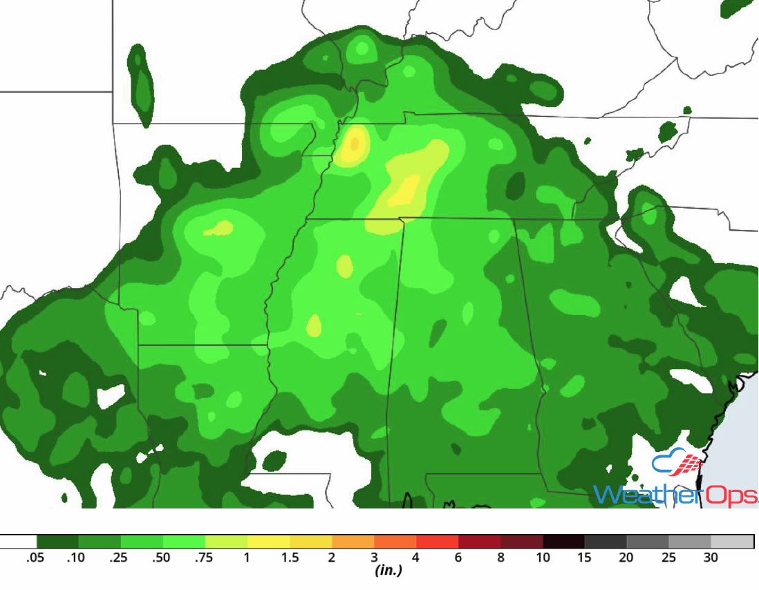
Rainfall Accumulation for Thursday
Tropical Update
Tropical Storm Debby is currently 945 miles west-northwest of the Azores and is moving northeastward at 17 mph. Maximum sustained winds are near 45 mph with higher gusts. Debby is forecast to dissipate later today or tonight.
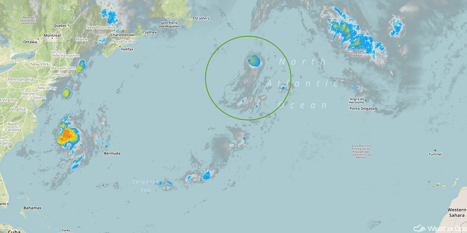
Enhanced Infrared Satellite
A Look Ahead
An area of low pressure is forecast to develop across western Texas on Sunday, bringing a risk for excessive rainfall to the region through Monday. Rainfall amounts of 2-4 inches with locally higher amounts in excess of 5 inches are expected. By Tuesday, the low will move northeastward, bringing the heavy rain into the Central Plains and Midwest. This activity will approach the Great Lakes on Wednesday.
