National Weather Summary for Thursday, August 18, 2016
by David Moran, on Aug 18, 2016 11:30:58 AM
A cold front moving into the Northern Plains will allow for the development of thunderstorms across the Northern Plains and Upper Mississippi Valley on Thursday. Further to the west, a weak upper level trough will provide lift for thunderstorms across the Central and Northern High Plains and Northern Rockies. As the cold front across the Plains continues to progress eastward, thunderstorms are expected to develop across the Central Plains and Upper Mississippi Valley. A weak upper level trough moving into the Rockies will support the development of thunderstorms along the Colorado Front Range and Southern Wyoming. Thunderstorms are expected to develop across the Midwest on Saturday ahead of a cold front. Across South Central Texas, heavy rain is expected along a stalled front.
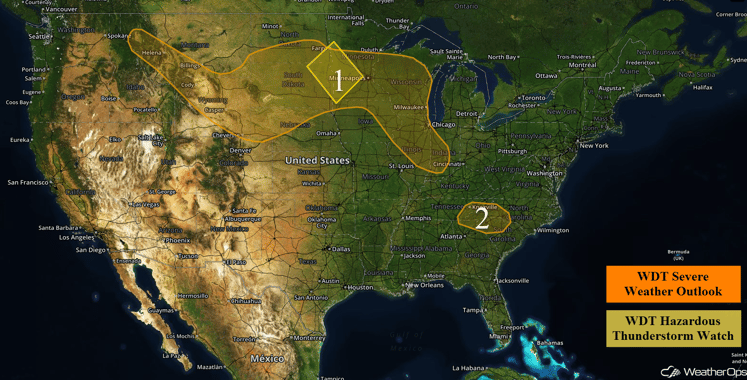
US Hazards
Region 1
A threat for severe weather is forecast on Thursday from portions of the Northern Rockies into the Midwest. Ongoing showers and thunderstorms across the Dakotas may pose a threat for severe wind over the next several hours as they track to the southeast and eventually into Southern Minnesota. Across the same region, additional showers and thunderstorms will be possible again later this afternoon with a threat for severe wind, large hail, and a tornado or two. Activity may develop into Wisconsin and Illinois by early evening with a lesser threat of severe wind and hail. To the west, the beginnings of a strong cold front will start to move southeastward into the Northern and Central Plains. A few severe storms will be possible across the higher terrain from Montana into Wyoming with a risk for isolated severe wind and hail, primarily after dark. As the front continues its southward progression, isolated to scattered showers and thunderstorms. some severe, will be possible from the Dakotas into Nebraska.
Update 1pm CDT: Severe thunderstorms with the potential for large hail and damaging winds are moving through southwestern Minnesota.
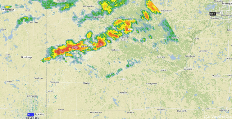
Radar 1pm CDT
Major Cities in Region: Helena, MT, Cheyenne, WY, Rapid City, SD, Bismarck, ND, Minneapolis, MN, Cedar Rapids, IA, Chicago, IL
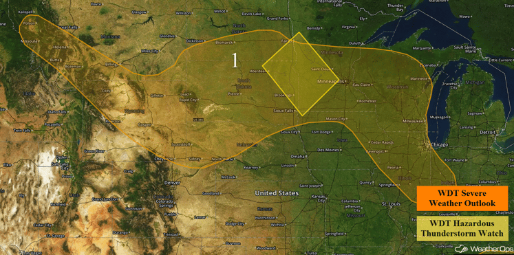
Region 1
Region 2
A persistent cluster of ongoing thunderstorms will track to the east throughout the day. This cluster will pose a small risk for locally damaging wind gusts.
Major Cities in Region: Knoxville, TN, Asheville, NC, Charlotte, NC, Greenville, SC
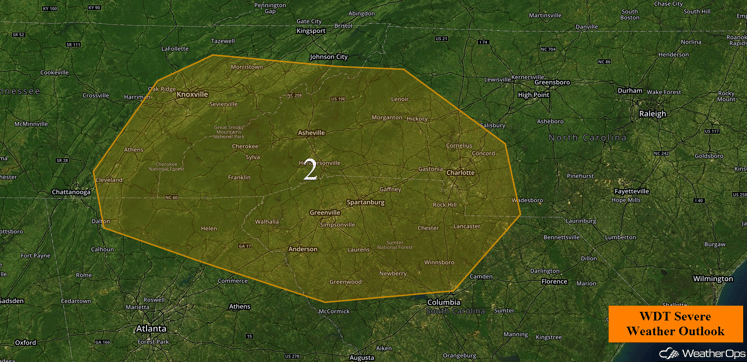
Region 2
Strong to Severe Thunderstorms Possible Friday for the Central Plains and Upper Mississippi Valley
An unstable air mass is expected to be in place across a large region extending from northern Oklahoma, through the Great Plains, Missouri Valley, and into the Upper Mississippi Valley by Friday afternoon. Lift associated with a cold front moving into this unstable air mass will allow for thunderstorms to develop. Thunderstorms will form in a line along and ahead of this cold front, with some thunderstorms likely to contain damaging wind gusts in excess of 60 mph. In addition to this severe weather threat, locally heavy rainfall will be possible. Widespread rainfall accumulations around an inch, with locally higher amounts in excess of three inches will be possible. The most likely area to receive heavy rainfall will be Kansas.
Major Cities in Region: Dodge City, KS, Kansas City, MO, Des Moines, IA, Davenport, IA
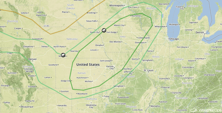
SPC Convective Outlook for Friday
Strong to Severe Thunderstorms Possible across Colorado Front Range and Southern Wyoming on Friday
Lift associated with a weak upper level trough moving into the Rockies should support the development of a few thunderstorms. While coverage of the thunderstorms should be limited, the few thunderstorms that do develop will likely become severe with large hail and damaging wind gusts likely to be the main hazards.
Major Cities in Region: Denver, CO, Cheyenne, WY
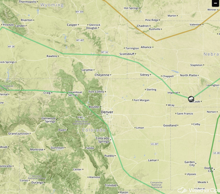
SPC Convective Outlook for Friday
Strong to Severe Thunderstorms Possible across the Midwest on Saturday
Thunderstorms are expected to develop across the Midwest on Saturday ahead of an advancing cold front. While conditions will only be marginally favorable for severe weather, a few thunderstorms could become strong and produce wind gusts in excess of 50 mph, frequent lightning, and heavy downpours.
Major Cities in Region: St. Louis, MO, Chicago, IL, Indianapolis, IN, Dayton, OH, Detroit, MI
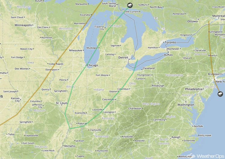
SPC Convective Outlook for Saturday
Excessive Rainfall Possible Saturday across South Central Texas
A cold front will approach the region and stall by late Saturday. Ahead of this cold front, widespread showers and thunderstorms will develop. Widespread rainfall accumulations of 1-2 inches with locally higher amounts in excess of 3 inches will be possible in some locations. This locally heavy rainfall may lead to flash flooding in some areas.
Major Cities in Region: San Angelo, TX, San Antonio, TX, Austin, TX, Waco, TX
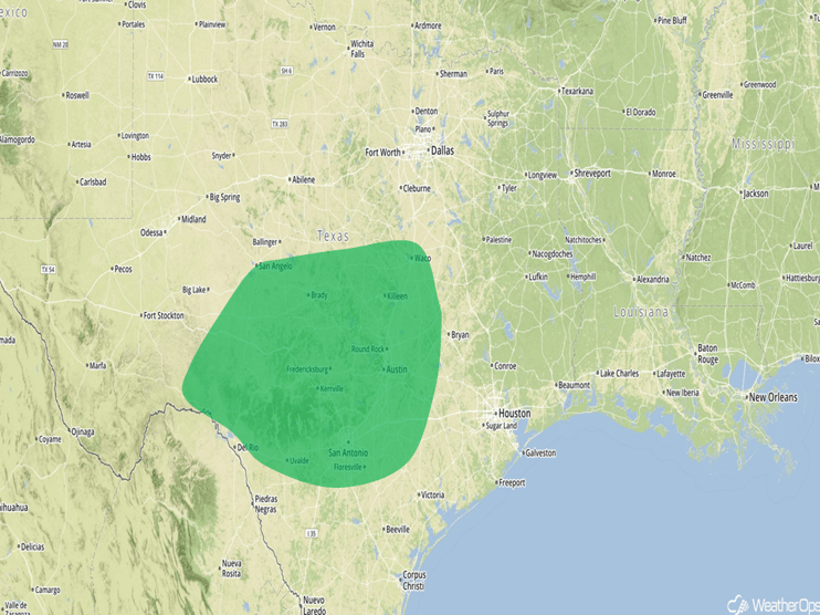
Excessive Rainfall Risk Outline for Saturday
This is just a brief look at current weather hazards. We can provide you site-specific forecast information for the purpose of protecting your personnel and assets. Try a 7-day demo right away and learn how timely precision weather information can enhance your bottom line.


