National Weather Summary for Monday, September 26, 2016
by David Moran, on Sep 26, 2016 11:20:23 AM
A cold front progressing through the Lower Great Lakes will bring a risk for thunderstorms to the Upper Ohio River Valley on Monday. Across portions of South Texas, a slow moving cold front will bring heavy to excessive rainfall to the region. As an area of low pressure develops over the Ohio Valley on Wednesday, heavy rain will be possible for portions of the Northeast.
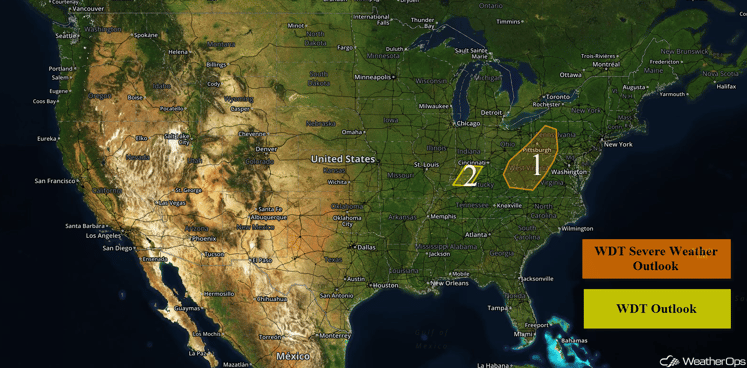
US Hazards
Region 1
A cold front extending from a low just north of the Great Lakes is moving into the eastern US this morning and showers and thunderstorms are ongoing along the front. This front should enter the region this afternoon and thunderstorms along it may intensify as daytime heating increases. This will be aided by forcing from an upper level low that is also moving over the area. Isolated strong to severe thunderstorms may develop along and just east of this front this afternoon and continue into the evening hours. The primary threat with these storms will be damaging winds.
Update 1:44pm EDT: Severe thunderstorms capable of damaging winds and small hail west of Charleston, WV.
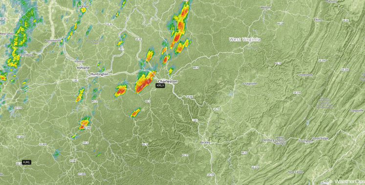
Radar 1:44pm EDT
Update 2:23pm EDT: Severe thunderstorms are currently moving through northeastern Tennessee. Hail and damaging winds will be possible with these storms.
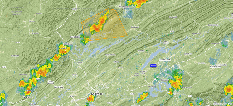
Radar 2:26pm EDT
Major Cities in Region: Charleston, WV, Pittsburgh, PA
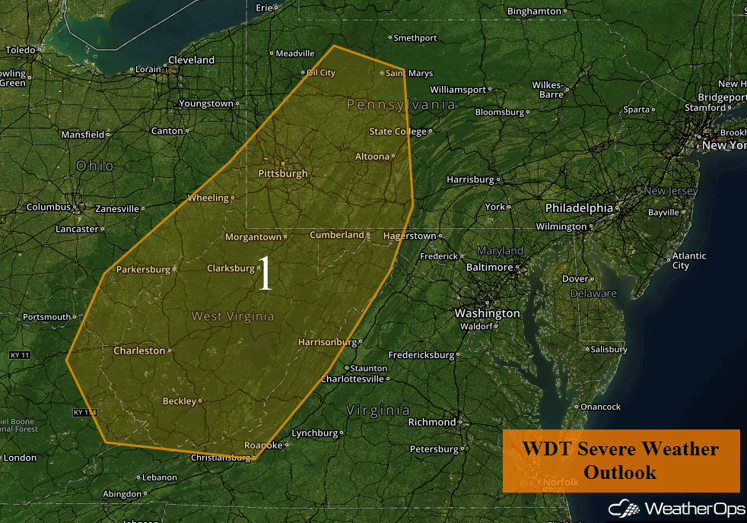
Region 1
Region 2
Numerous showers and thunderstorms are ongoing this morning along and ahead of an approaching cold front. This activity is not expected to pose any severe threats, but a few wind gusts in excess of 30 mph may be possible within the heavier showers. Otherwise, periods of moderate to heavy rain and lightning can be anticipated through much of the late morning hours. Activity will slowly progress eastward and should eventually clear the region by or before 1:00 PM EDT.
Major Cities in Region: Owensboro, KY, Louisville, KY
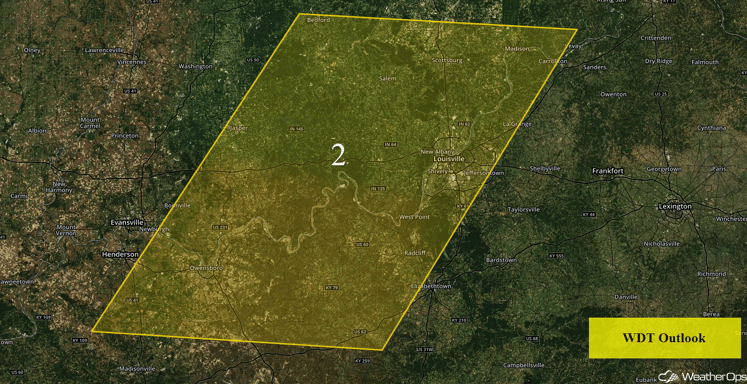
Region 2
Excessive Rainfall Possible Monday for Portions of South Texas
A very slow moving cold front moving across Texas will lead to heavy to excessive rainfall over portions of South Texas throughout the day on Monday. Total rainfall accumulations of 1-2 inches will be possible with locally heavier amounts in excess of 3 inches. Flooding and flash flooding may be of concern due to previous rainfall.
Major Cities in Region: Del Rio, TX
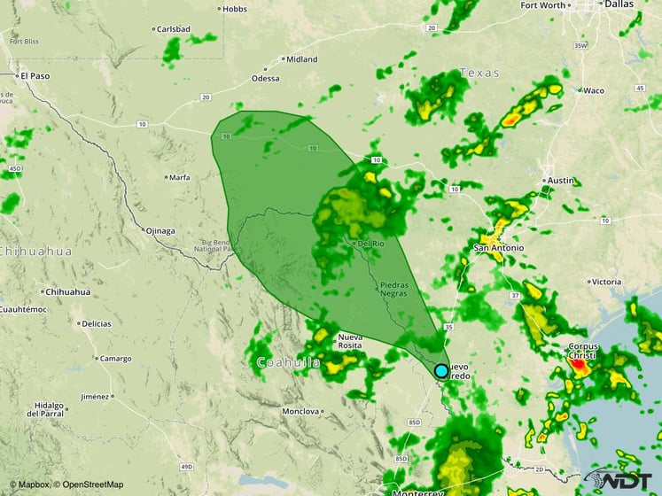
Excessive Rainfall Risk Outline for Monday
Excessive Rainfall Possible across the Northeast on Wednesday
As a new area of low pressure develops from a weakening low across the Upper Great Lakes on Tuesday, a weak warm front is forecast to lift to the north through portions of the Northeast. Additionally, a surface low off the coast will bring heavy rainfall chances along the northwest and western side of the surface low. With the surface low offshore the weak and developing low across the Ohio Valley, heavy to excessive rainfall may develop over portions of the Northeast. Total rainfall accumulations of 1-3 inches will be possible with locally heavier amounts in excess of 4 inches.
Major Cities in Region: Washington, DC, Philadelphia, PA, Atlantic City, NJ
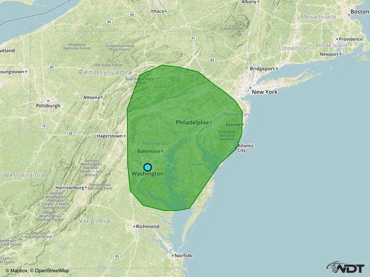
Excessive Rainfall Risk Outline for Wednesday
Tropical Update
Showers and thunderstorms associated with an area of low pressure located about 1100 miles east-southeast of the Windward Islands (green oval) continue to show signs of organization. Environmental conditions are expected to be conductive for development, and a tropical depression is likely to develop around midweek while to low moves westward to west-northwestward at 15-20 mph. Interests in the eastern and central Caribbean sea, including the northern coast, including the northern coast of South America, should monitor the progress of this system. Regardless of development, heavy rains and gusty winds should spread over the Windward Islands and portions of the southern Lesser Antilles beginning late Tuesday or Wednesday.
Shower activity increased overnight in association with the remnants of Tropical Storm Lisa (red oval). Unfavorable environmental conditions are expected to cause the circulation to open up into a trough of low pressure.
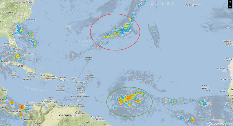
Tropical Infrared Satellite
A Look Ahead
Thunderstorms will be possible for portions of the Northeast on Friday as a warm front lifts northward across the Northeast. Gusty winds will be the primary hazards with these storms. By the weekend, an upper level low will move through the Northern Rockies and allow for the development of an area of low pressure in the lee of the Rockies on Sunday. Thunderstorms may develop along the associated warm front across the Plains.
This is just a brief look at current weather hazards. We can provide you site-specific forecast information for the purpose of protecting your personnel and assets. Try a 7-day demo right away and learn how timely precision weather information can enhance your bottom line.


