by David Moran, on Sep 24, 2018 11:11:23 AM
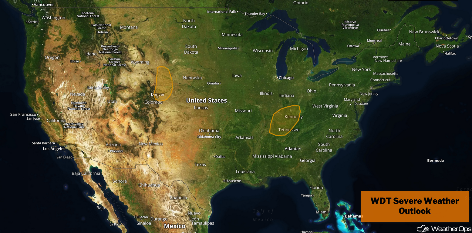
Thunderstorms may develop across portions of the Front Range of the Rockies on Monday as upslope flow increases. A weak upper level trough may allow for the development of thunderstorms across Tennessee and Kentucky. This trough may bring a risk of excessive rainfall to the Ohio Valley.
- Potential for Thunderstorms Monday along the Front Range
- Thunderstorms for Portions of Tennessee and Kentucky on Monday
- Excessive Rainfall Monday for the Ohio Valley
- Risk for Thunderstorms from the Mid Mississippi Valley into the Great Lakes Tuesday
- Potential for Excessive Rainfall Tuesday from the Ohio Valley into the Great Lakes
- Excessive Rainfall for New England on Tuesday
- Thunderstorms Wednesday from the Ohio Valley into New England
- Tropical Update
US Hazards
Potential for Thunderstorms Monday along the Front Range
Upslope flow may provide sufficient forcing for the development of thunderstorms along the Front Range this afternoon. They will likely be scattered in nature and extend northward into Nebraska and Wyoming. Strong winds and small hail will be the primary hazards with the stronger storms. This activity will move eastward through the evening.
Major Cities in Region: Fort Collins, CO, Cheyenne, WY, Denver, CO, North Platte, NE
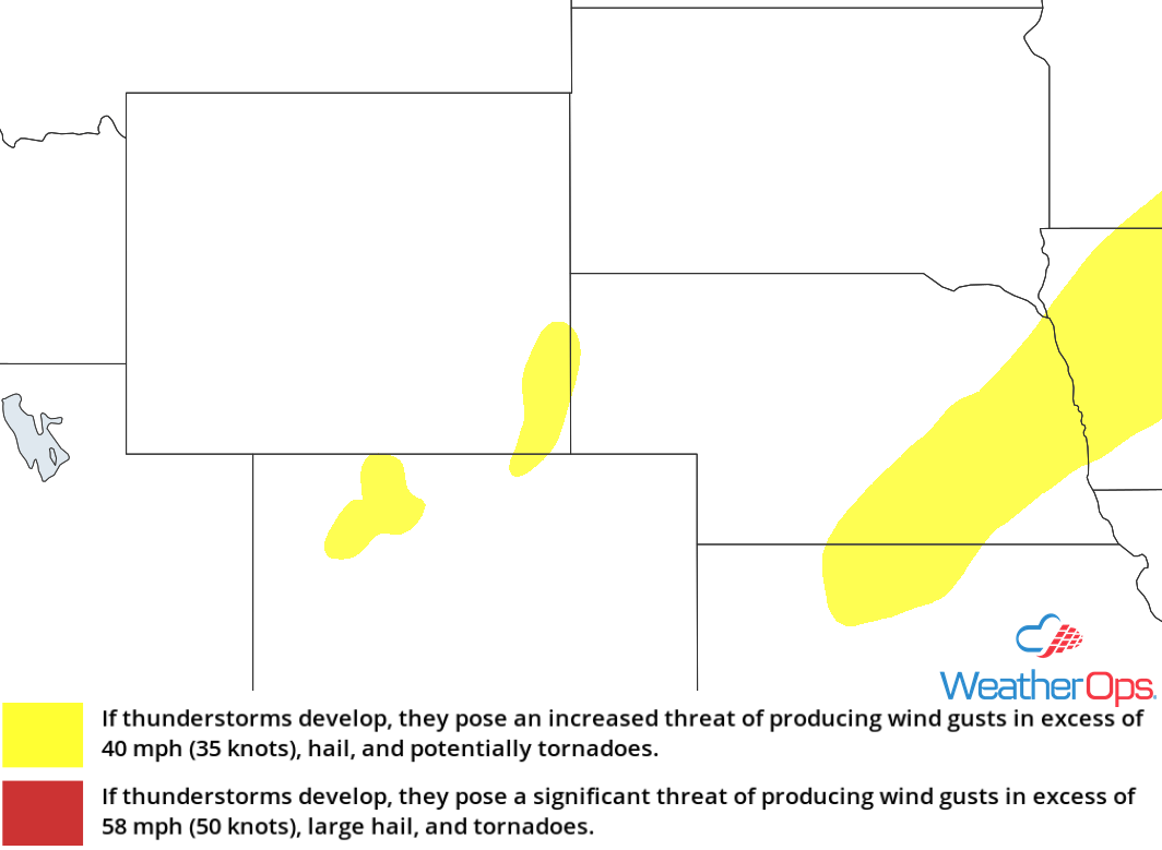
Thunderstorm Risk for Monday
Thunderstorms for Portions of Tennessee and Kentucky on Monday
Warm, moist air will be moving northward through the day. This moisture, coupled with forcing from a weak upper level trough, will allow for the development of strong to severe thunderstorms. Damaging winds will be the primary hazard with these storms.
Major Cities in Region: Nashville, TN, Louisville, KY, Lexington, KY
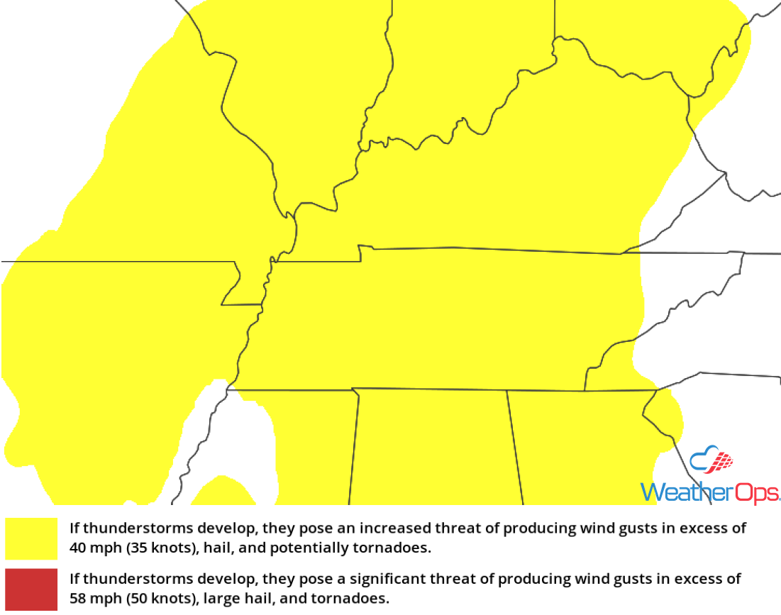
Thunderstorm Risk for Monday
Excessive Rainfall Monday for the Ohio Valley
The same trough described above will allow for a risk for excessive rainfall across the Ohio Valley. Rainfall amounts of 1-3 inches with locally higher amounts in excess of 4 inches are expected. Given the rainfall from previous days, there will be a risk for flash flooding.
Major Cities in Region: Louisville, KY, Cincinnati, OH, Lexington, KY
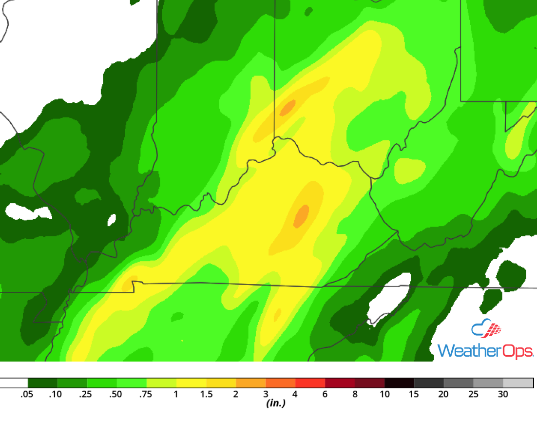
Rainfall Accumulation for Monday
Risk for Thunderstorms from the Mid Mississippi Valley into the Great Lakes Tuesday
An area of low pressure will be moving through eastern Canada on Tuesday with its trailing cold front moving into the region. Cooler air will move in aloft with warm moist air near the surface. Instability may be sufficient for the development of scattered severe thunderstorms along and ahead of the front. Damaging winds and large hail will be the primary hazards, but an isolated tornado or two cannot be ruled out.
Major Cities in Region: Davenport, IA, St. Louis, MO, Madison, WI, Milwaukee, WI, Chicago, IL, Indianapolis, IN, Louisville, KY, Cincinnati, OH, Detroit, MI, Columbus, OH, Cleveland, OH
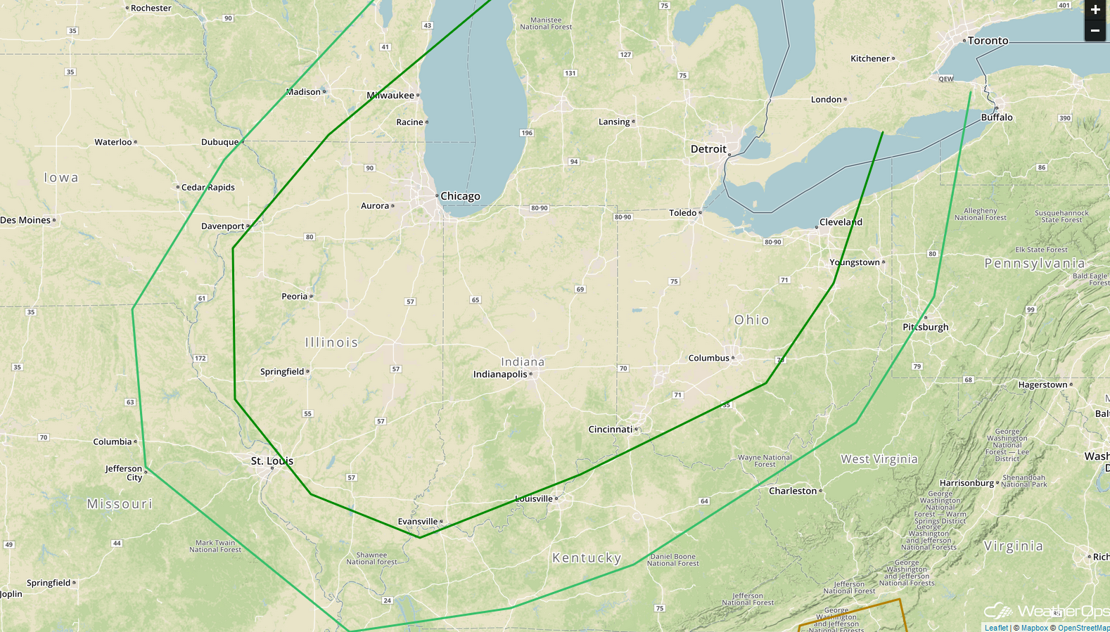
SPC Convective Outlook for Tuesday
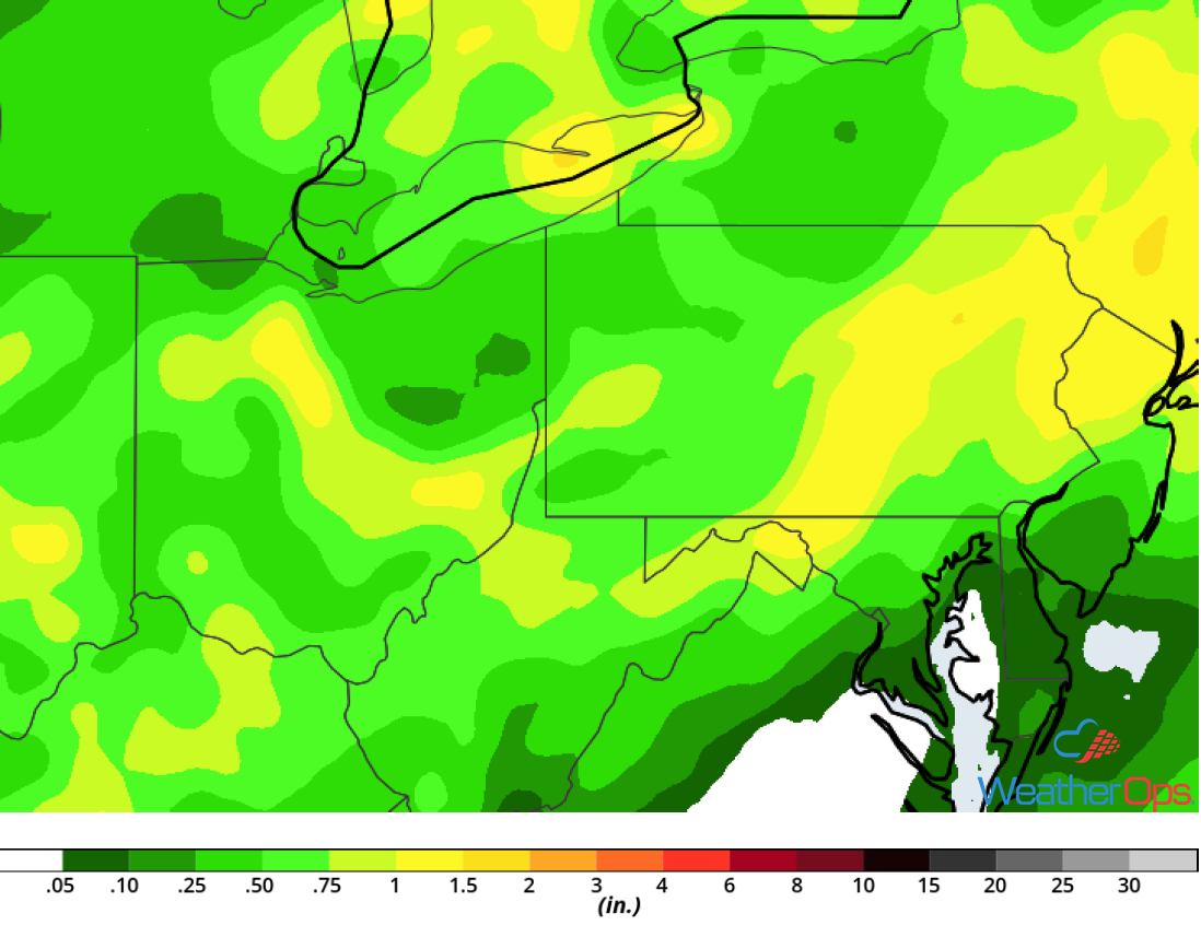
Potential for Excessive Rainfall Tuesday from the Ohio Valley into the Great Lakes
The same cold front described above will pose a risk for excessive rainfall from the Ohio Valley into the Great Lakes. Rainfall amounts will range 1-2 inches and locally higher amounts in excess of 3 inches. Given the rainfall from previous days, there will be a risk for flash flooding.
Major Cities in Region: Toledo, OH, Detroit, MI, Columbus, OH, Charleston, WV
Rainfall Accumulation for Tuesday
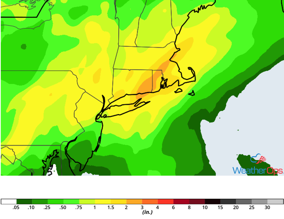
Excessive Rainfall for New England on Tuesday
Warm moist air moving northward and daytime heating will allow instability to build, leading to the development of thunderstorms capable of producing heavy to excessive rainfall. Activity should develop during the afternoon; a few of these storms could be strong. Rainfall amounts will range 1-2 inches with locally higher amounts in excess of 3 inches.
Major Cities in Region: Hartford, CT, Providence, RI, Boston, MA
Rainfall Accumulation for Tuesday
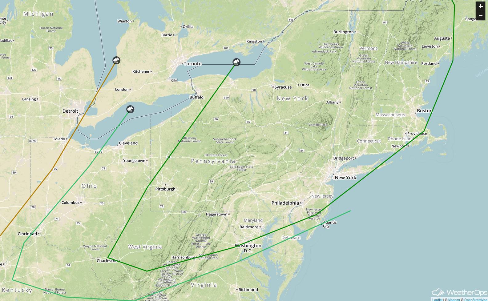
Thunderstorms Wednesday from the Ohio Valley into New England
The cold front expected to bring a risk for thunderstorms to portions of the Mid Mississippi Valley into the Great Lakes on Tuesday will move eastward Wednesday. As it does, it will serve as a focus for thunderstorm development from the Ohio Valley into New England. Some thunderstorms may become severe with large hail and damaging winds the primary hazards, but an isolated tornado or two cannot be ruled out.
Major Cities in Region: Cincinnati, OH, Columbus, OH, Cleveland, OH, Charleston, WV, Pittsburgh, PA, Buffalo, NY, Syracuse, NY, Philadelphia, PA, New York, NY, Boston, MA, Portland, ME, Augusta, ME
SPC Convective Outlook for Wednesday
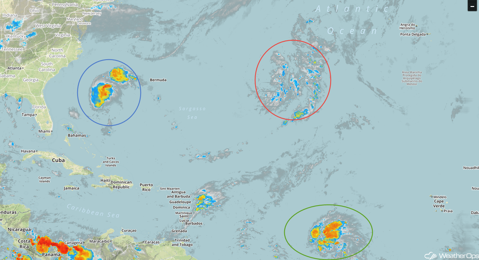
Tropical Update
The remnants of Tropical Storm Kirk (green oval) are 1470 miles east of the Windward Islands and moving westward at 23 mph. This general motion is expected to continue over the next few days with little change in strength. Maximum sustained winds are at 40 mph.
Subtropical Storm Leslie (red oval) is 1240 miles west of the Azores and is moving eastward at 5 mph. This general motion is expected to continue through Tuesday night. A turn toward the east-northeast with an increase in forward speed is expected on Wednesday. Maximum sustained winds are at 40 mph. Leslie is forecast to strengthen by mid week.
A broad area of low pressure located between Bermuda and the Bahamas (blue oval) continues to produce a limited amount of shower and thunderstorm activity. Conditions are expected to become more favorable for development during the next day or so while the system moves west-northwestward to northwestward. By Tuesday night and Wednesday, upper level winds will increase, limiting the potential for additional development.
Enhanced Infrared Satellite
A Look Ahead
Showers and thunderstorms may develop across the Southeast on Thursday ahead of a cold front. On Friday, showers are forecast across portions of the Central Plains. By Saturday, thunderstorms will extend from the Plains into the Great Lakes. Additional activity may develop across the Upper Midwest on Sunday.