


by David Moran, on Nov 12, 2018 11:14:32 AM
Snow will continue for portions of the Plains and Midwest on Monday as an area of low pressure moves eastward. Showers and thunderstorms will continue across the Southeast as an area of low pressure and cold front move across the region. This activity may produce excessive rainfall. Elevated winds and seas will continue through Thursday morning as a cold front progresses eastward.
- Snow for the Southern Plains and Midwest on Monday
- Thunderstorms Monday across the Southeast
- Excessive Rainfall for the Southeast Monday
- Elevated Winds and Seas through Thursday Morning for the Gulf of Mexico
- Potential for Snow across the Northeast Tuesday
- Excessive Rainfall for Georgia on Wednesday
- Tropical Update
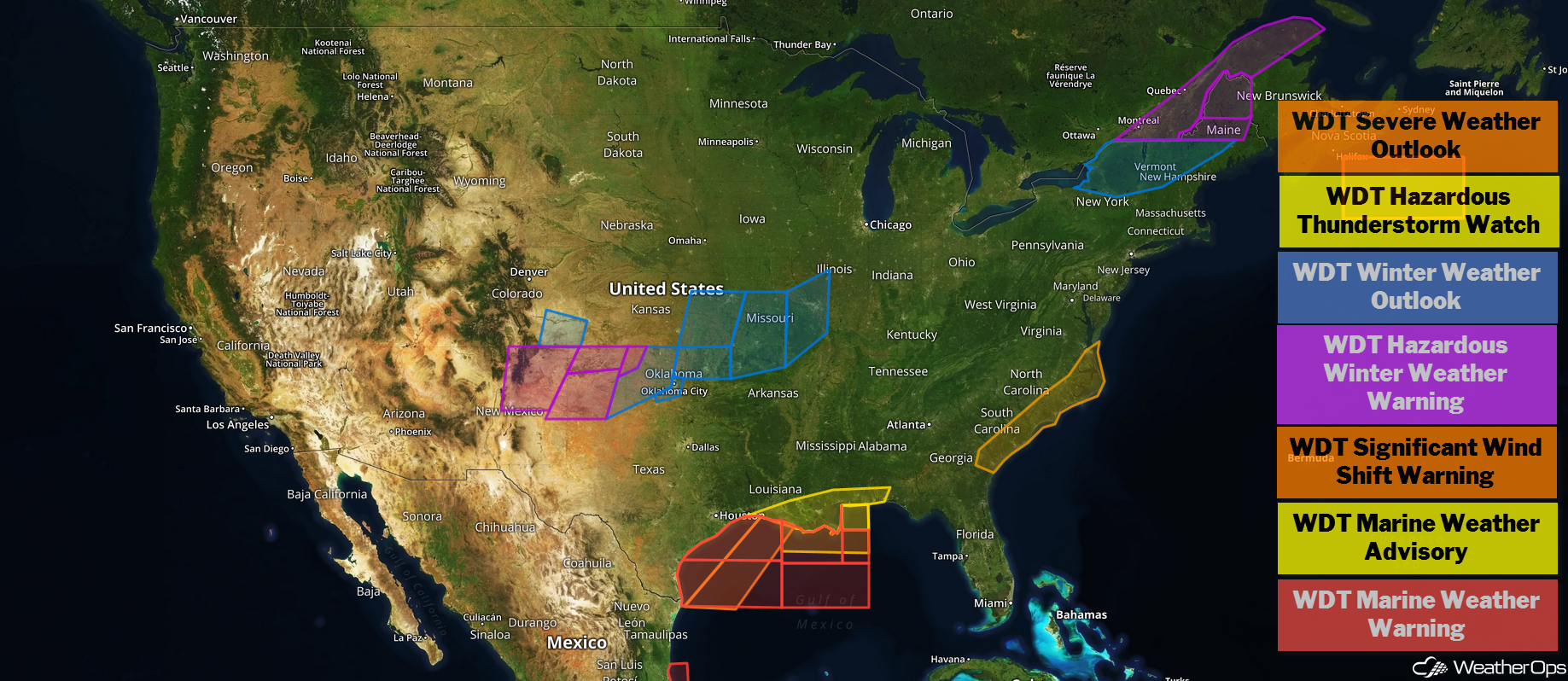
US Hazards
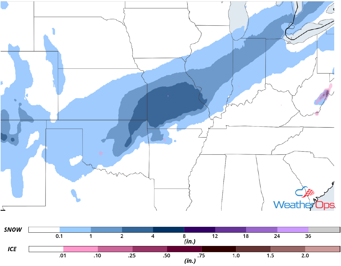
Snow for the Southern Plains and Midwest on Monday
A strong cold front will continue to push eastward bringing cold air to the region. A disturbance is making its way across the region, producing moderate to heavy snowfall across the Texas Panhandle, South and Central Kansas, as well as Western and Central Oklahoma. Snow accumulations of 1-3 inches are expected across Central and Eastern Oklahoma as well as Central Missouri. Across Illinois, Indiana, and portions of Michigan, up to two inches are forecast. Gusty winds could result in blowing snow and reduced visibilities.
Major Cities in Region: Oklahoma City, OK, Tulsa, OK, Springfield, MO, St. Louis, MO, Indianapolis, IN, Detroit, MI
Thunderstorms Monday across the Southeast
Thunderstorms will continue through the day ahead of a cold front. Ample moisture has destabilized the atmosphere. As the day progresses, daytime heating will allow instability to build and a line of thunderstorms is expected to develop along the cold front later today. Gusty winds will be the primary hazard, but an isolated tornado cannot be ruled out.
Major Cities in Region: Lafayette, LA, Baton Rouge, LA, New Orleans, LA, Mobile, AL, Pensacola, FL, Atlanta, GA, Columbia, SC Raleigh, NC
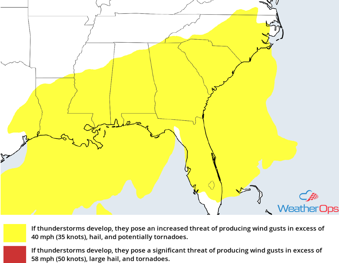
Thunderstorm Risk for Monday
Excessive Rainfall for the Southeast Monday
In addition to the thunderstorm potential described above, there will be a potential for excessive rainfall across portions of the Southeast. Rainfall amounts will range 1-3 inches, with locally higher amounts in excess of 4 inches, resulting in flooding and flash flooding.
Major Cities in Region: Tallahassee, FL, Atlanta, GA, Macon, GA

Rainfall Accumulation for Monday
Elevated Winds and Seas through Thursday Morning for the Gulf of Mexico
A cold front will begin tracking across the Gulf of Mexico around midday today. Ahead of the front, winds will be west-southwesterly to west-northwesterly at 15-20 knots. Behind the front, winds will be north-northwesterly to northerly at 25-35 knots with gusts in excess of 40 knots. In addition, thunderstorms will continue along and ahead of the cold front. Waterspouts, wind gusts in excess of 40 knots, heavy rain, and frequent lightning will be the primary hazards with these storms, Seas will range 9-12 feet near the shore and 12-17 feet in the deeper waters. Across the central Gulf of Mexico, seas of 10-15 feet are expected. Elevated winds and seas will continue through early Thursday morning.
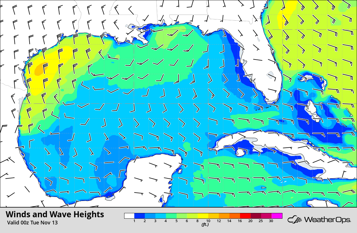
Winds and Wave Heights 6pm CST Monday
Potential for Snow across the Northeast Tuesday
A strong area of low pressure is expected to move northward across the region Tuesday into early Wednesday morning. Snowfall totals will range 1-3 inches from Upstate New York into Maine. Warmer air will be present across the region, which could allow for freezing rain along the southern periphery of the low, but most areas will see just a glaze of ice. Gusty winds could lead to blowing or drifting snow, making roads slick and hazardous. Use extreme caution while driving, particularly on the Tuesday evening commute.
Major Cities in Region: Albany, NY, Burlington, VT, Bangor, ME, Presque Isle, ME
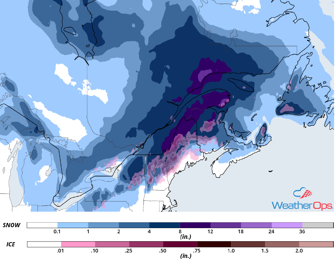
Snow Accumulation for Tuesday
Excessive Rainfall for Georgia on Wednesday
An area of low pressure is expected to produce showers and thunderstorms across the region on Wednesday. Ample moisture is expected across the region, which should allow this activity to produce moderate to heavy rainfall. Widespread rainfall totals of 2-3 inches are expected with locally heavier amounts in excess of 4 inches are expected. Rainfall from Monday and Tuesday will saturate the ground, leading to a risk for increased flooding and flash flooding.
Major Cities in Region: Albany, GA, Atlanta, GA, Macon, GA
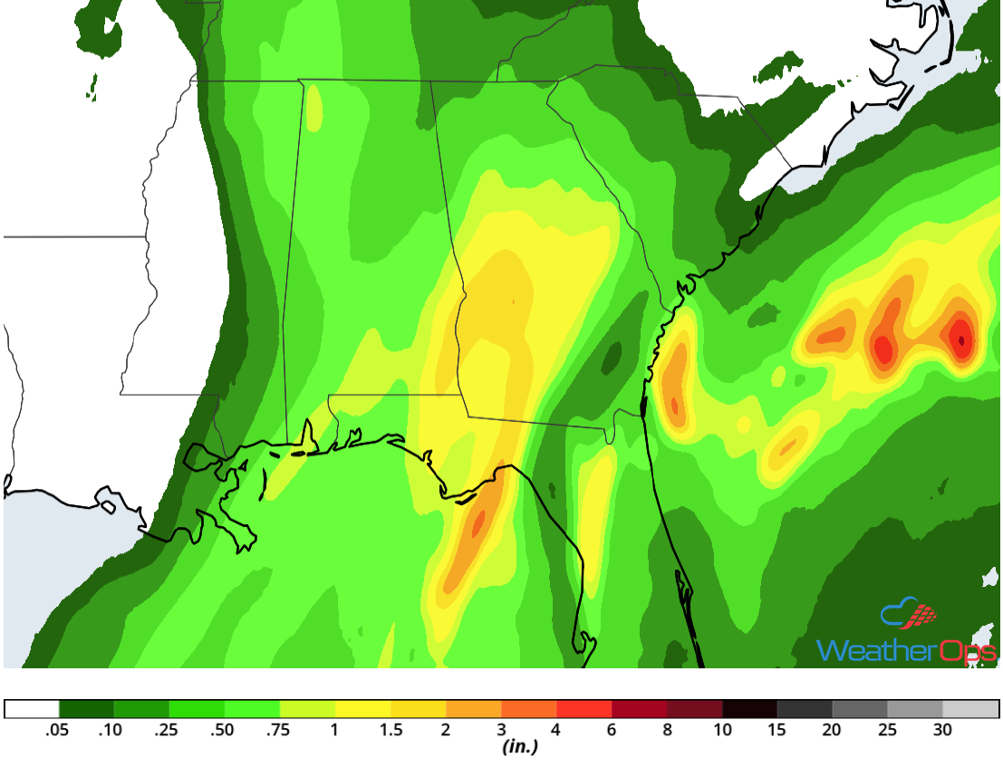
Rainfall Accumulation for Wednesday
Tropical Update
A tropical wave about 200 miles east of the Leeward Islands is producing a large area of showers and thunderstorms over the western tropical Atlantic. Shower and thunderstorm activity has increased and conditions are expected to become more favorable for the development of a tropical depression or storm over the next day or two. This disturbance is forecast to move westward to west-northwestward for the next few days, passing near or north of the Leeward Islands, Puerto Rico, Hispaniola, and the southeastern Bahamas.
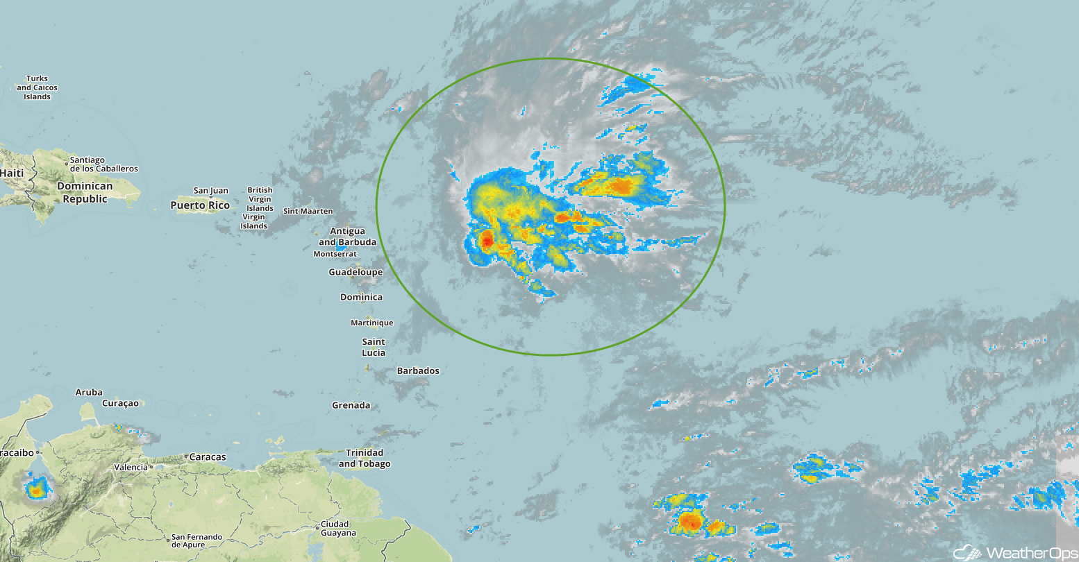
Enhanced Infrared Satellite
A Look Ahead
Snow may develop across the Ohio Valley on Thursday as an area of low pressure moves eastward. Further east, freezing rain is forecast over portions over the Mid Atlantic and the Northeast. By Friday, the freezing rain will transition to snow and spread northward across the Northeast and New England. Going into the weekend, snow is forecast from the Central Rockies into the Midwest on Saturday. Light snow and freezing rain may develop Sunday across portions of Texas and Oklahoma.
