National Weather Summary for Monday, June 26, 2017
by David Moran, on Jun 26, 2017 10:23:01 AM
Scattered thunderstorms are forecast for portions of the Southwest Monday as instability increases throughout the day. A cold front moving into the Pacific Northwest will allow for the development of thunderstorms during the afternoon and evening on Monday.
- Risk for Thunderstorms Monday across the Southwest and Central/Southern Plains
- Thunderstorm Potential across the Northwest on Monday
- Strong to Severe Thunderstorms across the Great Plains Tuesday
- Thunderstorms Wednesday for the Central Plains and Midwest
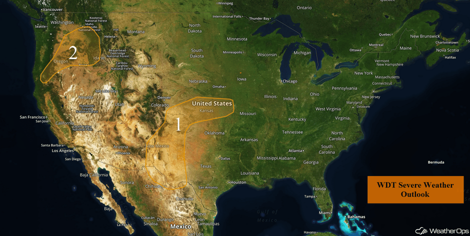 US Hazards
Risk for Thunderstorms Monday across the Southwest and Central/Southern Plains
Although there will be an upper level ridge off to the west in the Desert Southwest, upslope flow across the mountain ranges of New Mexico, as well as forcing from an area of low pressure, will result in strong to severe thunderstorms across the region today. Most of the remnant convection from yesterday has begun to dissipate across portions of Texas. With daytime heating, instability will begin to increase this afternoon. In addition, low level moisture will overspread the region and wind shear will increase during the late afternoon. With these conditions in place, there will be an increase in shower and thunderstorm coverage with a few thunderstorms becoming strong to severe. Large hail and damaging winds will be the primary hazards with these storms.
Further to the north into eastern Colorado and Kansas, the aforementioned area of low pressure will allow the development of showers and thunderstorms. Instability will increase in coverage and intensity with a few of these storms becoming strong to severe in nature. The primary hazards with any of these storms will be hail and damaging winds.
Update 1:31pm CDT: Severe thunderstorm capable of hail and damaging winds southwest of Kearney, NE.
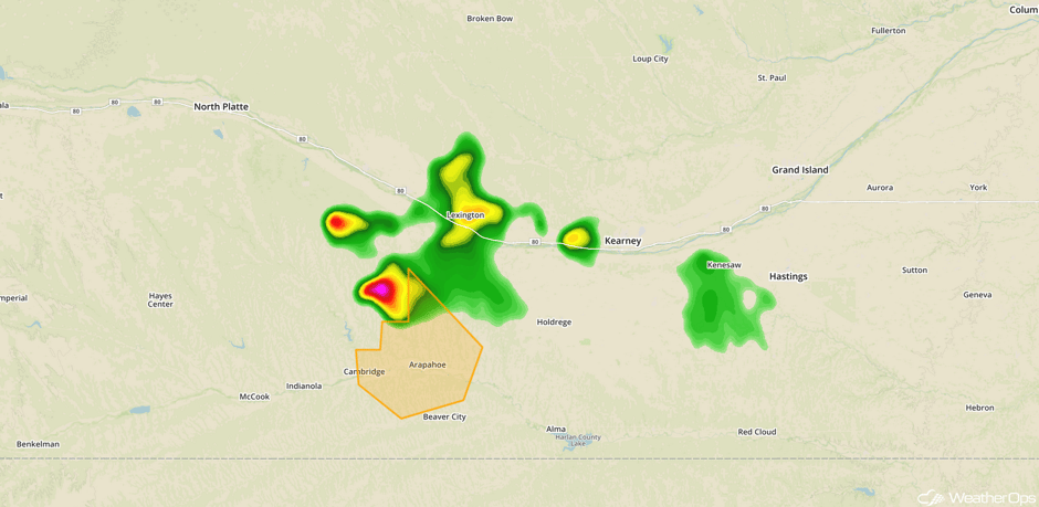 Radar 1:31pm CDT
Major Cities in Region: Albuquerque, NM, Santa Fe, NM, Wichita, KS, Kansas City, KS
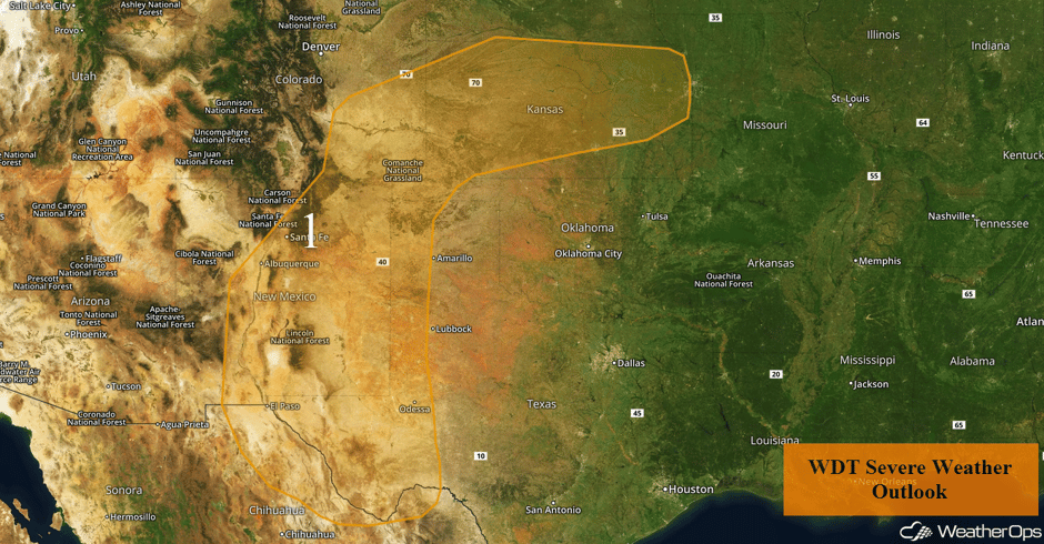 Region 1
Thunderstorm Potential across the Northwest on Monday
Thunderstorms are expected across portions of the Northwest as an upper level disturbance moves into the region. Ahead of this disturbance, daytime heating and increased moisture will enhance instability. With strong wind shear in place, thunderstorms are expected to develop this afternoon and into the evening. Some of these thunderstorms will be strong to severe with large hail and damaging winds the primary hazards.
Major Cities in Region: Boise, ID
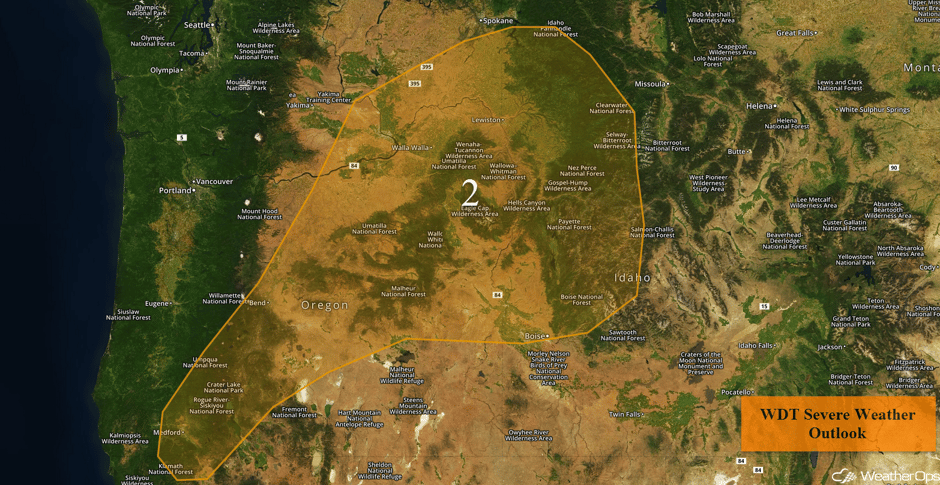 Region 2
Strong to Severe Thunderstorms across the Great Plains Tuesday
As a strong upper level disturbance tracks eastward across the Northern US, a surface low and associated fronts will push eastward. This will lead to a risk for thunderstorms during the afternoon and evening across the Northern and Central Plains, and possibly as far south as the southern High Plains. Conditions are expected to be favorable for the development of thunderstorms capable of large hail, damaging winds, and tornadoes. By the late evening and overnight hours, storms may evolve into one or more organized complexes, with the severe threat transitioning to hail and damaging winds.
Major Cities in Region: Cheyenne, WY, Denver, CO, North Platte, NE, Bismarck, ND, Pierre, SD, Sioux Falls, SD, Omaha, NE
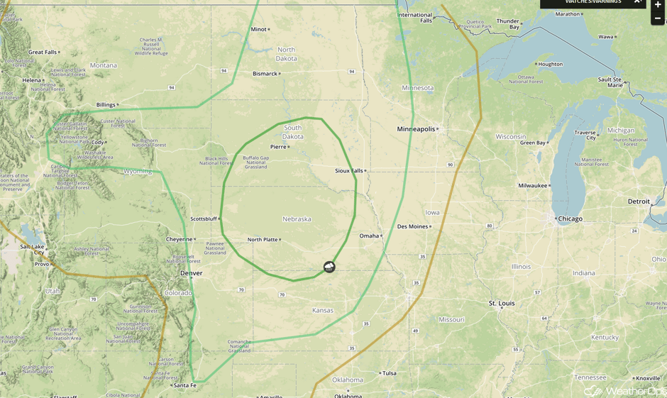 SPC Convective Outlook for Tuesday
Thunderstorms Wednesday for the Central Plains and Midwest
An area of low pressure and associated cold front are forecast to advance east and southeast into the Midwest and Central Plains on Wednesday, providing a focus for thunderstorm development. Thunderstorms will likely be ongoing during the morning hours for some locations, with additional development likely later in the day, during the afternoon, and evening. Some strong or severe thunderstorms may be possible early in the day, but more robust storms will be likely during the afternoon and evening. Large hail, damaging winds, and tornadoes will all be potential hazards with these storms.
Major Cities in Region: Goodland, KS, Dodge City, KS, Wichita, KS, Omaha, NE, Kansas City, MO, Des Moines, IA, Minneapolis, MN, Green Bay, WI, Milwaukee, WI
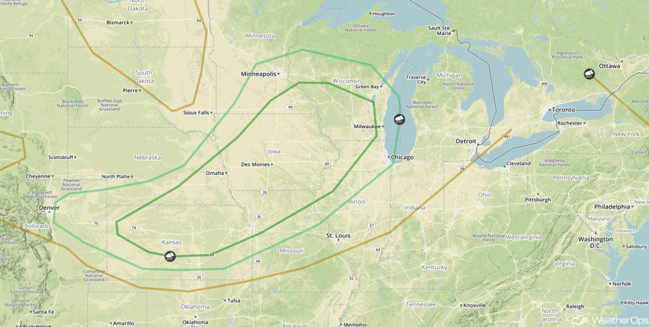 SPC Convective Outlook for Wednesday
A Look Ahead
There is a risk for thunderstorms across the Central Plains and Midwest as an area of low pressure intensifies across the Plains before lifting northeastward. Thunderstorms that develop may produce hail, damaging winds, and tornadoes. In addition, rainfall amounts of 1-3 inches with locally higher amounts in excess of 4 inches are possible for portions of Illinois, Iowa, and Missouri. By Friday, the risk for thunderstorms will shift from the Central Plains into the Lower Mississippi Valley as the cold front associated with the area of low pressure over the Plains moves southeastward. Gusty winds and hail will be the primary hazards.
This is just a brief look at current weather hazards. We can provide you site-specific weather forecast information for the purpose of protecting your personnel and assets and to assess your weather risk. Try a 7-day demo right away and learn how timely precision weather information can enhance your bottom line.


