


by David Moran, on Jul 2, 2018 11:18:31 AM
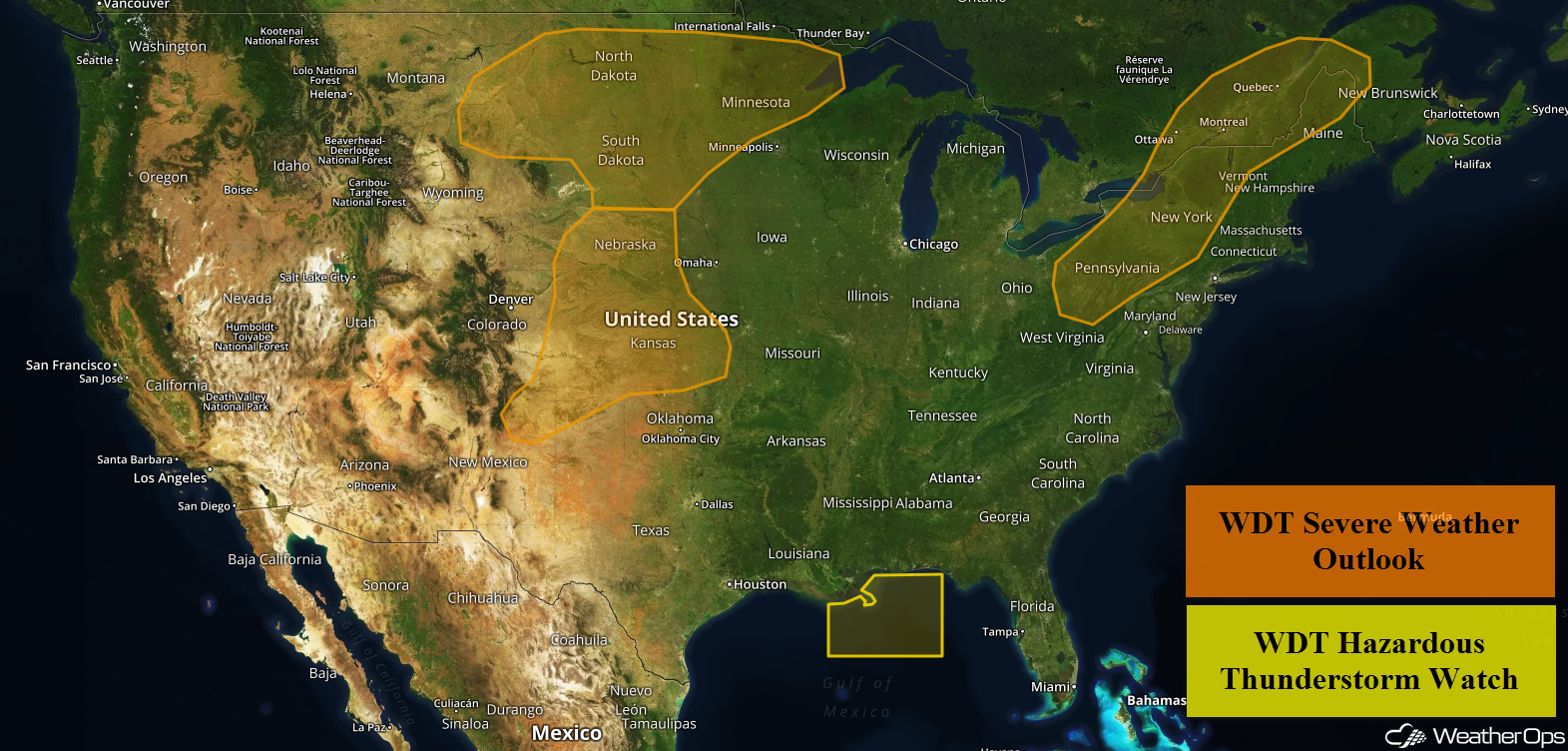
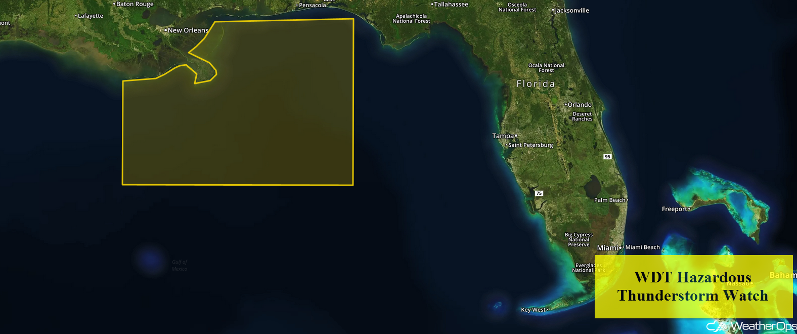
Thunderstorms will continue across portions of the northern Gulf of Mexico through early Monday evening as an upper level trough moves across the region. An intensifying trough will bring a potential for thunderstorms to portions of the Northern Plains. There will be a risk for excessive rainfall across the Missouri Valley and Upper Midwest as thunderstorms develop ahead of a cold front. Thunderstorms may develop across the Central and Southern Plains during the afternoon hours ahead of a dry line. A cold front will be the focus for the development of thunderstorms across portions of the Northeast.
- Continued Thunderstorms for Portions of the Gulf of Mexico Monday
- Thunderstorms Monday across the Northern Plains
- Excessive Rainfall for the Missouri Valley and Upper Midwest on Monday
- Potential for Thunderstorms on Monday across the Central and Southern Plains
- Risk for Thunderstorms across the Northeast on Monday
- Thunderstorms Tuesday for the Northern Plains
- Excessive Rainfall for the Upper Midwest on Tuesday
- Thunderstorm Potential Wednesday for the Upper Midwest
 US Hazards

Continued Thunderstorms for Portions of the Gulf of Mexico Monday
Thunderstorms will continue for portions of the Gulf of Mexico through early Monday evening as an upper level trough continues to move across the region. Wind gusts in excess of 35 knots, heavy rain, frequent lightning, and waterspouts will all be potential hazards with these storms.
 WDT Hazardous Thunderstorm Watch
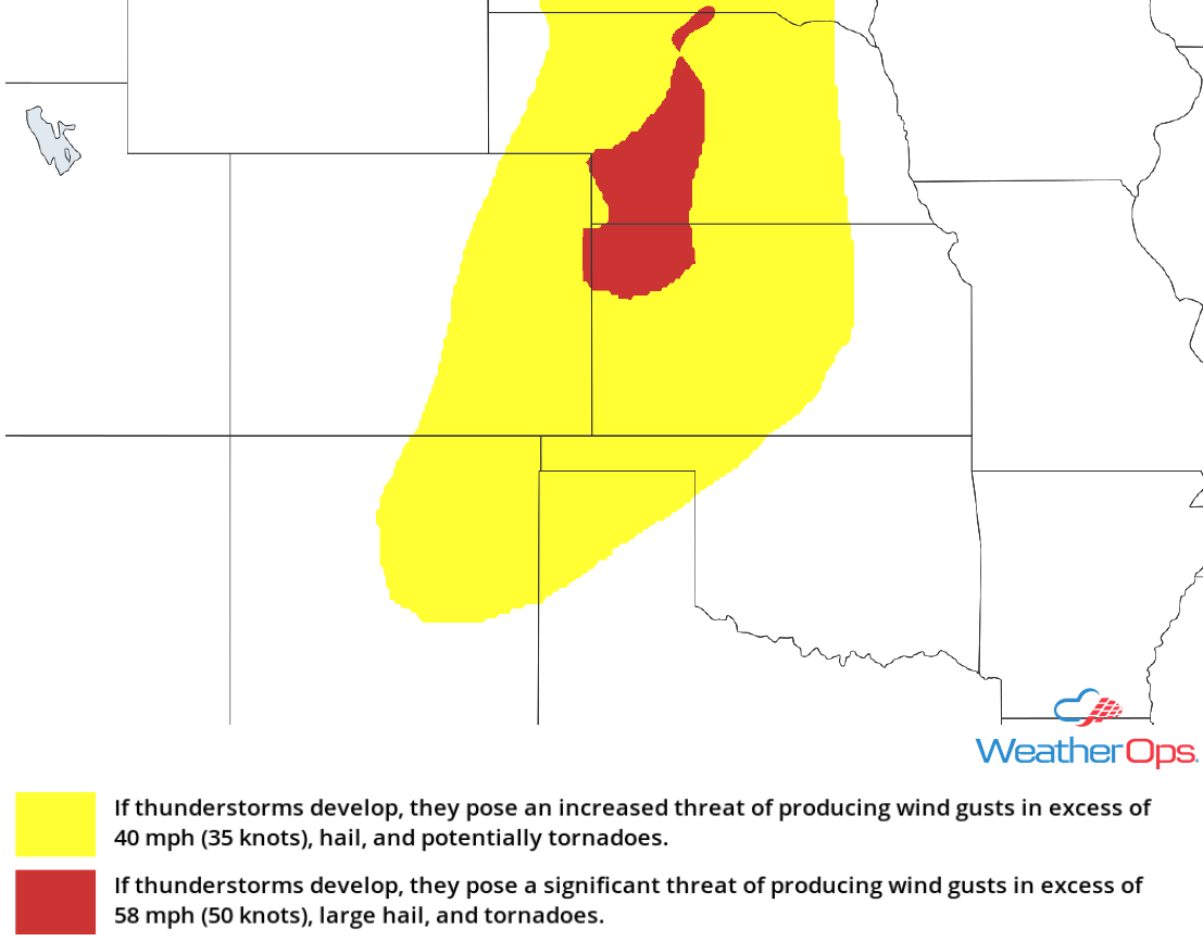
Thunderstorms Monday across the Northern Plains
A developing trough over the Central US will be the primary focus for thunderstorm development today. Thunderstorms, some severe, will likely develop across Montana, through the Dakotas, and into Central Minnesota. Severe winds and large hail will be the primary hazards, but an isolated tornado or two cannot be ruled out.
Major Cities in Region: Glasgow, MT, Minot, ND, Bismarck, ND, Pierre, SD, Fargo, ND
 Thunderstorm Risk for Monday
Excessive Rainfall for the Missouri Valley and Upper Midwest on Monday
Scattered thunderstorms may develop during the afternoon and evening ahead of a cold front, with some storms producing heavy to excessive rainfall. Rainfall amounts in excess of an inch are forecast, allowing for a threat for flooding and runoff into early Tuesday morning.
Major Cities in Region: Sioux Falls, SD, Sioux City, IA, Des Moines, IA
 Rainfall Accumulation for Monday
Potential for Thunderstorms on Monday across the Central and Southern Plains
Thunderstorms may develop ahead of a dryline from southern Nebraska southward into the Oklahoma and Texas Panhandles. While shear will be somewhat lacking, there will be a low risk for severe thunderstorms capable of producing strong winds and hail, mainly before dark.
Major Cities in Region: Amarillo, TX, Guymon, OK, Goodland, KS, North Platte, NE
Thunderstorm Risk for Monday
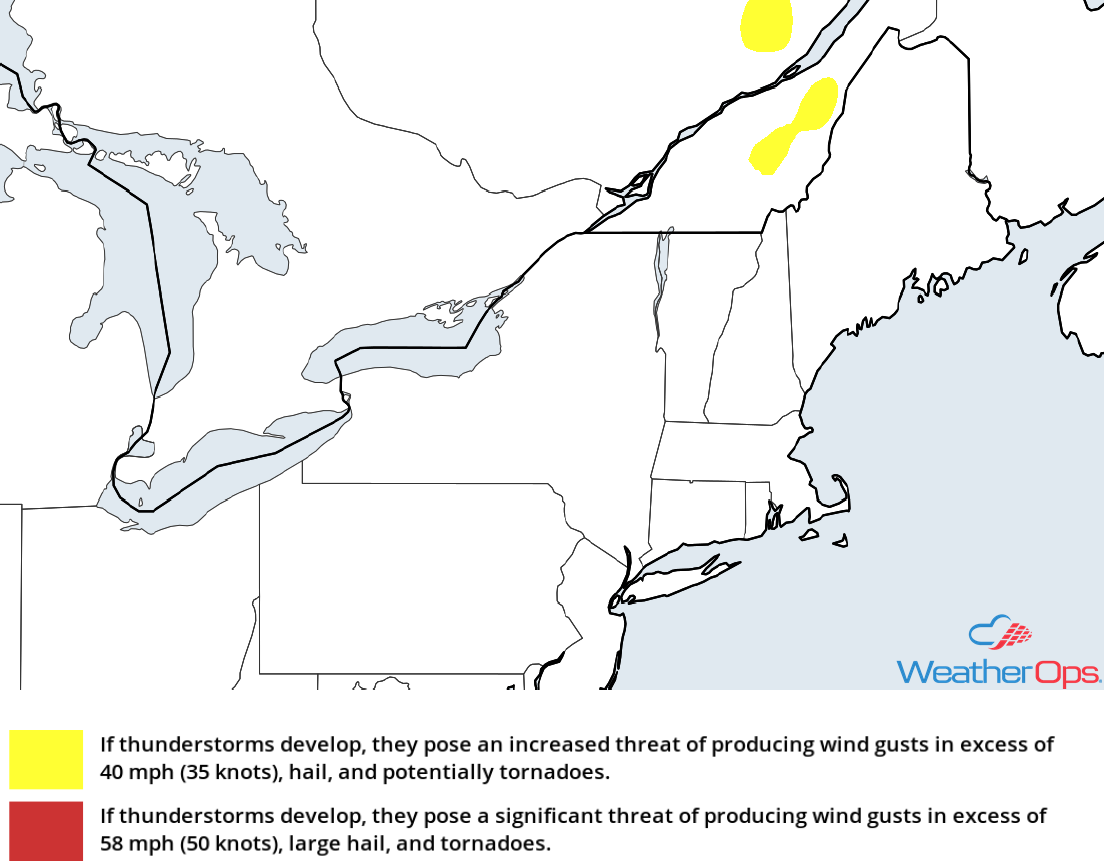
Risk for Thunderstorms across the Northeast on Monday
A cold front is expected to approach the US/Canada border throughout the day. Strong daytime heating and forcing ahead of the cold front should promote the development of scattered showers and thunderstorms during the afternoon and evening across portions of the Northeast. Severe winds and small hail will be the primary hazards with these storms.
Major Cities in Region: Pittsburgh, PA, Buffalo, NY, Rochester, NY, Burlington, VT
 Thunderstorm Risk for Monday
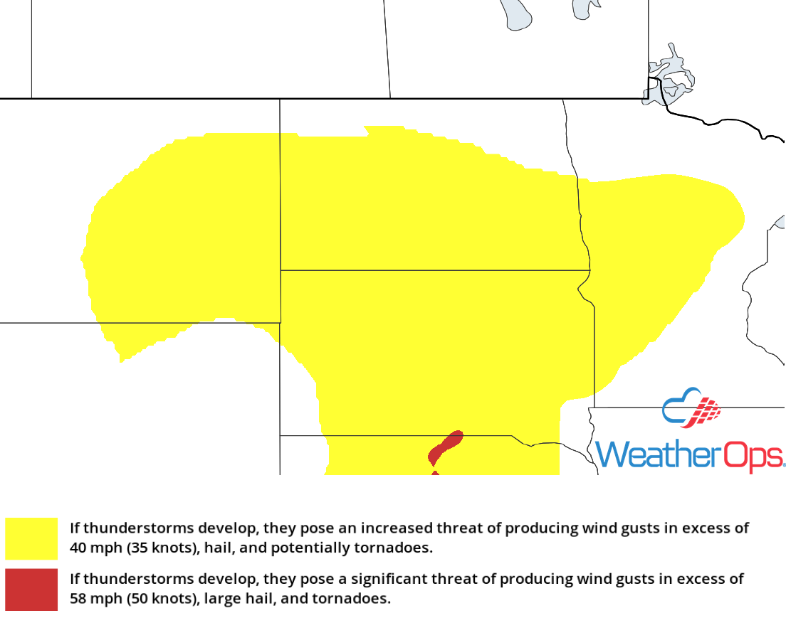
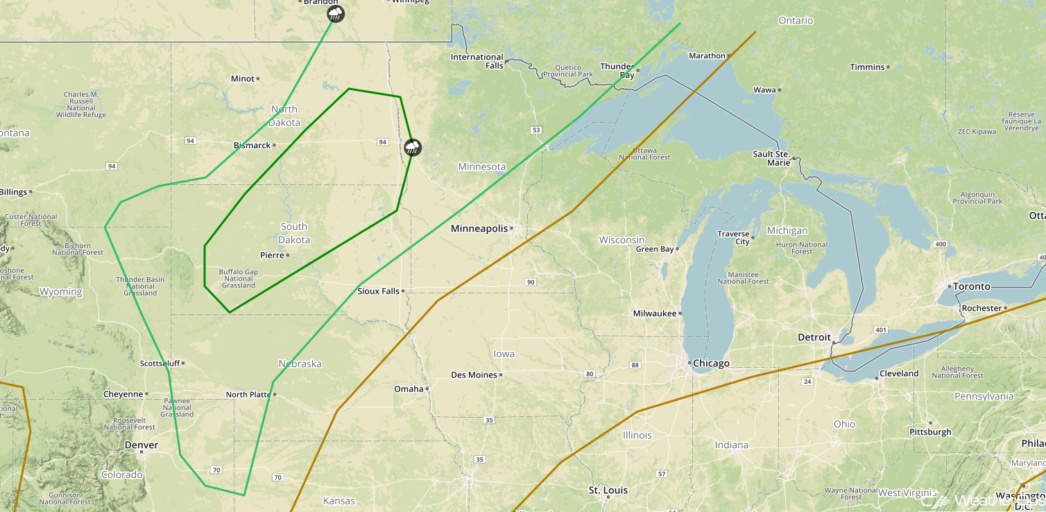
Thunderstorms Tuesday for the Northern Plains
Warm, moist air and instability will be in place across the region on Tuesday. As an upper level trough approaches, forcing will support the development of scattered showers and thunderstorms during the afternoon across Nebraska and into the Dakotas. While wind shear will be lacking for the development of more organized thunderstorms, a few storms may produce severe winds into the night time hours.
Major Cities in Region: Scottsbluff, NE, Rapid City, SD, North Platte, NE, Bismarck, ND, Pierre, SD, Grand Forks, ND, Fargo, ND
 SPC Convective Outlook for Tuesday
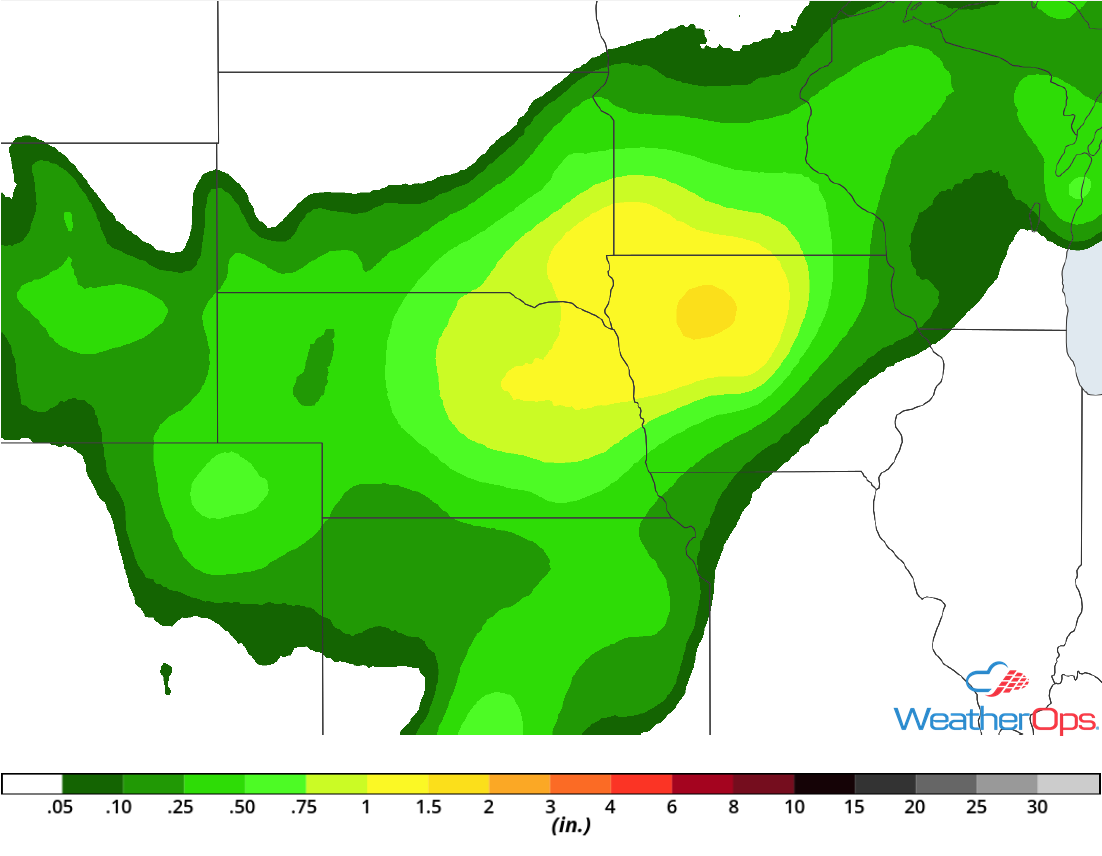
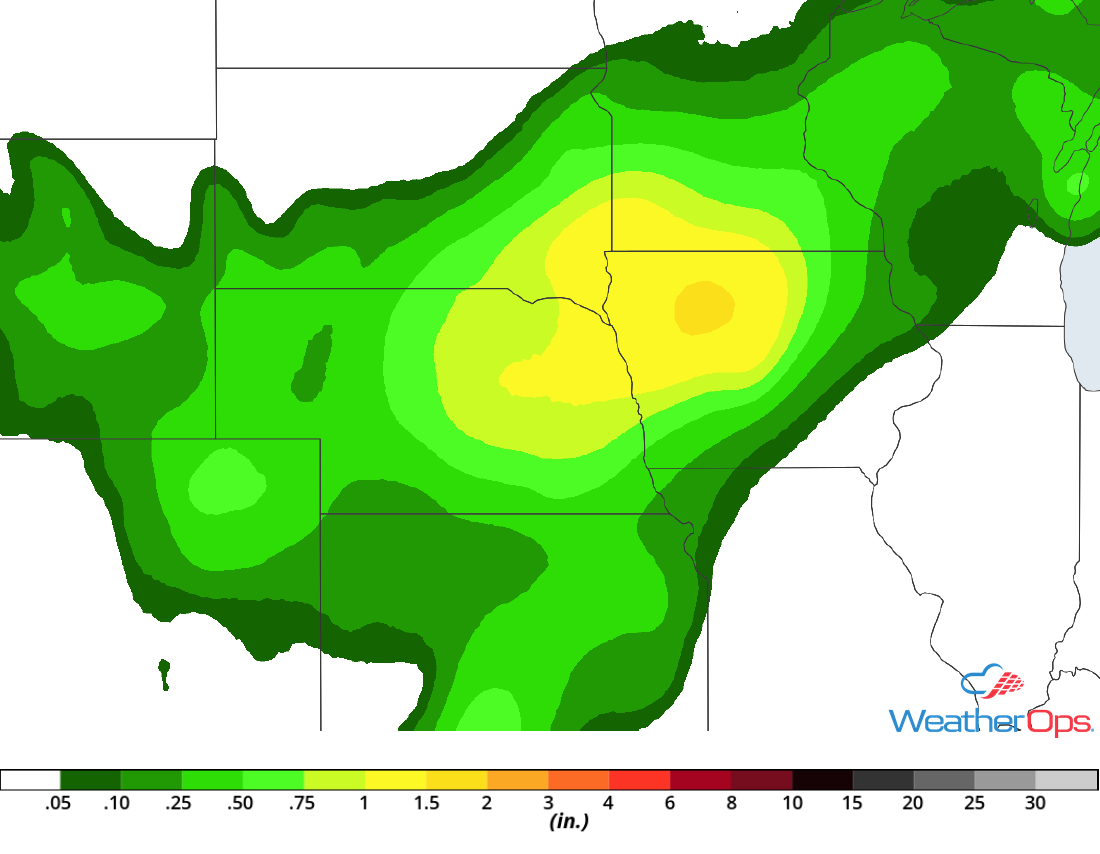
Excessive Rainfall for the Upper Midwest on Tuesday
In addition to the thunderstorms described above, there will be a potential for heavy rainfall. Rainfall amounts near 2 inches with locally heavier amounts are expected, resulting in a potential for flooding and local runoff through early Wednesday morning.
Major Cities in Region: Sioux Falls, SD, Sioux City, IA, Omaha, NE
 Rainfall Accumulation for Tuesday
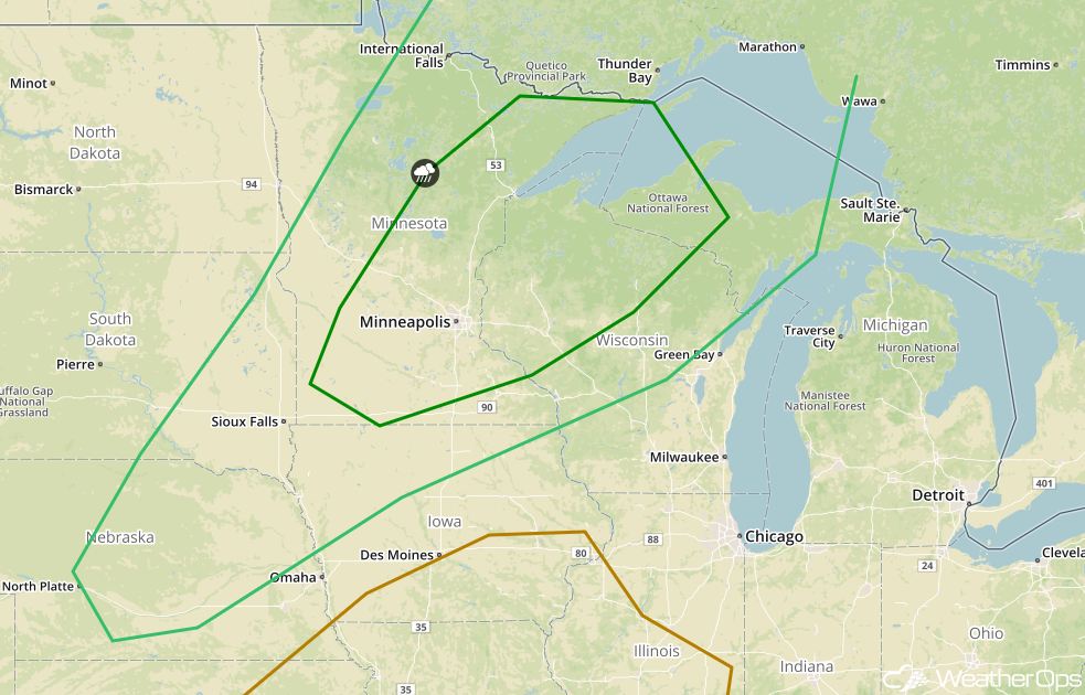
Thunderstorm Potential Wednesday for the Upper Midwest
An area of low pressure will move into southern Canada on Wednesday. Instability and strong wind shear will allow for the development of thunderstorms ahead of the associated cold front. Large hail, damaging winds, and isolated tornadoes will be potential hazards with these storms. The greatest threat will stretch from Minnesota into Upper Michigan.
Major Cities in Region: North Platte, NE, Sioux Falls, SD, International Falls, MN, Minneapolis, MN, Duluth, MN, Wausau, WI, Marquette, MI
 SPC Convective Outlook for Wednesday
A Look Ahead
Thunderstorms will extend from the Great Lakes into the Central Plains on Thursday ahead of a cold front. By Friday, showers and thunderstorms may develop across portions of the Ohio Valley. Going into the weekend, thunderstorms are forecast across the Southeast on Saturday. Another round of storms may develop across the Southeast Sunday.
This is just a brief look at current weather hazards. We can provide you site-specific weather forecast information for the purpose of protecting your personnel and assets and to assess your weather risk. Try a 7-day demo right away and learn how timely precision weather information can enhance your bottom line.
