


by David Moran, on Jul 16, 2018 11:02:34 AM
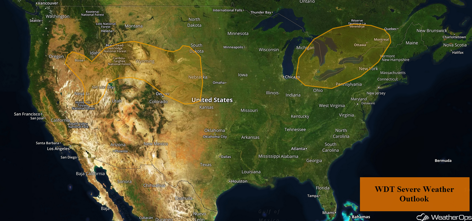
Thunderstorms may develop across the eastern Great Lakes on Monday ahead of a cold front. An upper level disturbance will aid in the development of thunderstorms from Wyoming into the Central High Plains. The risk for excessive rainfall will continue through Tuesday across the Southwest as monsoonal moisture remains in place.
- Thunderstorms for the Eastern Great Lakes on Monday
- Risk for Thunderstorms Monday across Wyoming and the Central High Plains
- Excessive Rainfall for the Southwest through Tuesday
- Thunderstorm Potential Tuesday across the High Plains
- Potential for Excessive Rainfall for the High Plains on Tuesday
- Thunderstorms for the Northeast on Tuesday
- Excessive Rainfall Tuesday for the Eastern Seaboard
- Potential for Thunderstorms across the Central Plains on Wednesday
US Hazards
Thunderstorms for the Eastern Great Lakes on Monday
A cold front tracking through the Great Lakes will reach eastern portions of the region early this afternoon. Along and ahead of the front, conditions will become favorable for thunderstorm development, some of which may be severe. Strong and damaging winds, as well as large hail, will be the primary hazards with these storms.
Major Cities in Region: Cleveland, OH, Buffalo, NY, Syracuse, NY, Burlington, VT
Thunderstorm Risk for Monday
Risk for Thunderstorms Monday across Wyoming and the Central High Plains
Strong to severe thunderstorms are expected across portions of Wyoming into the High Plains on Monday. An upper level disturbance will move into the region, which will initiate the development of thunderstorms over Wyoming this afternoon. This activity will increase in coverage while shifting eastward. Damaging winds and large hail will be the primary hazards with any storms that become severe.
Major Cities in Region: Casper, WY, Cheyenne, WY, North Platte, NE Grand Island, NE
Thunderstorm Risk for Monday
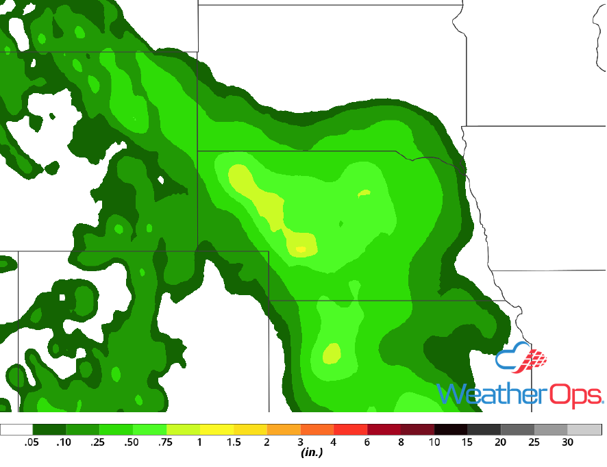
Excessive Rainfall for the Southwest through Tuesday
Above normal monsoonal moisture content will remain in place across the Southwest through at least Tuesday. As with previous days, scattered thunderstorm development will occur for much of the day. The heaviest storms are expected near and over the higher terrain. Slow moving, heavy thunderstorms will pose a risk for flash flooding, especially for places that have received multiple days of rain.
Major Cities in Region: Flagstaff, AZ, Phoenix, AZ, Tucson, AZ

Rainfall Accumulation through Tuesday
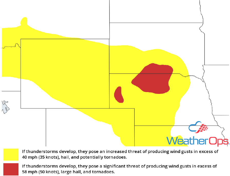
Thunderstorm Potential Tuesday across the High Plains
Strong to severe thunderstorms may develop across the High Plains on Tuesday. A thunderstorm complex may be ongoing during the morning, posing a risk for strong or damaging winds. By the afternoon, conditions will be favorable for the development of additional thunderstorms. There is some uncertainty regarding placement and coverage due to morning activity and associated outflow boundaries. Large hail, damaging winds, and tornadoes will be potential hazards with any storms that develop.
Major Cities in Region: Rapid City, SD, North Platte, NE, Dodge City, KS, Grand Island, NE, Salina, KS
SPC Convective Outlook for Tuesday
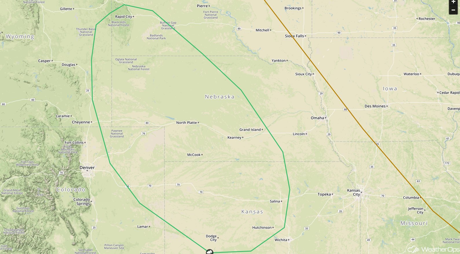
Potential for Excessive Rainfall for the High Plains on Tuesday
In addition to the severe weather potential described above, there will be a risk for heavy to excessive rain. Rainfall accumulations of 1-2 inches with locally higher amounts in excess of 3 inches are expected, leading to the potential for flash flooding.
Major Cities in Region: North Platte, NE
Rainfall Accumulation for Tuesday
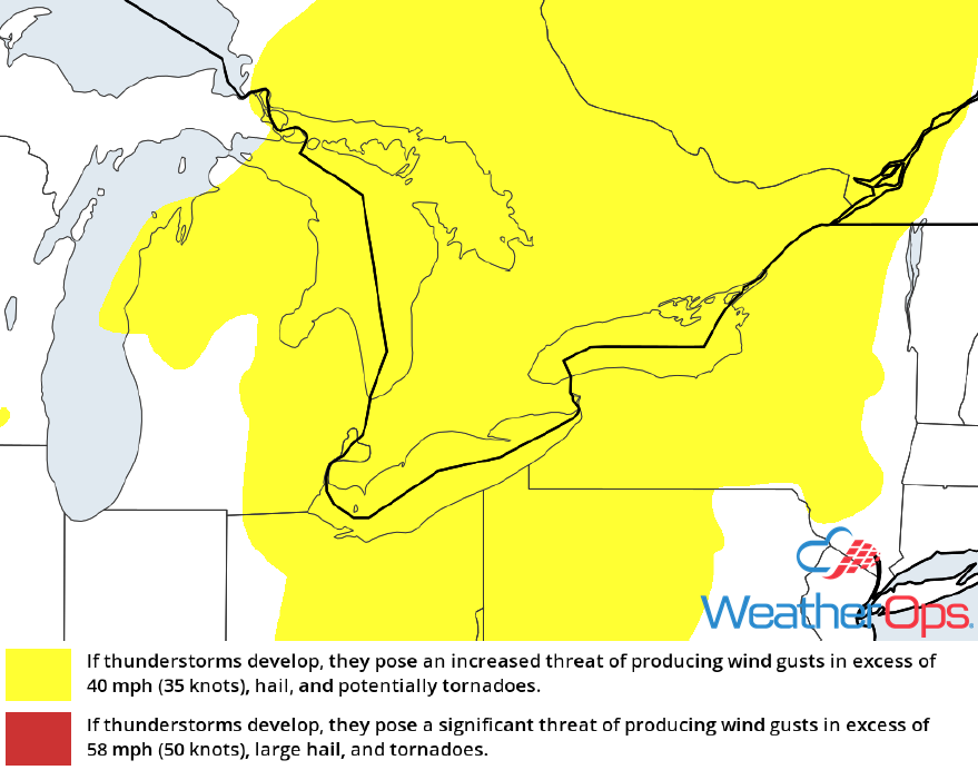
Thunderstorms for the Northeast on Tuesday
Strong to severe thunderstorms may develop across the Northeast on Tuesday as an upper level trough and cold front move into the region. With abundant moisture in place, showers and thunderstorms are expected for much of the day. While this activity may limit instability somewhat, conditions should become favorable for the development of thunderstorms along and ahead of the front during the afternoon. Strong and damaging winds will be the primary hazards with these storms.
Major Cities in Region: Baltimore, MD, Albany, NY, Burlington, VT, New York, NY, Manchester, NH
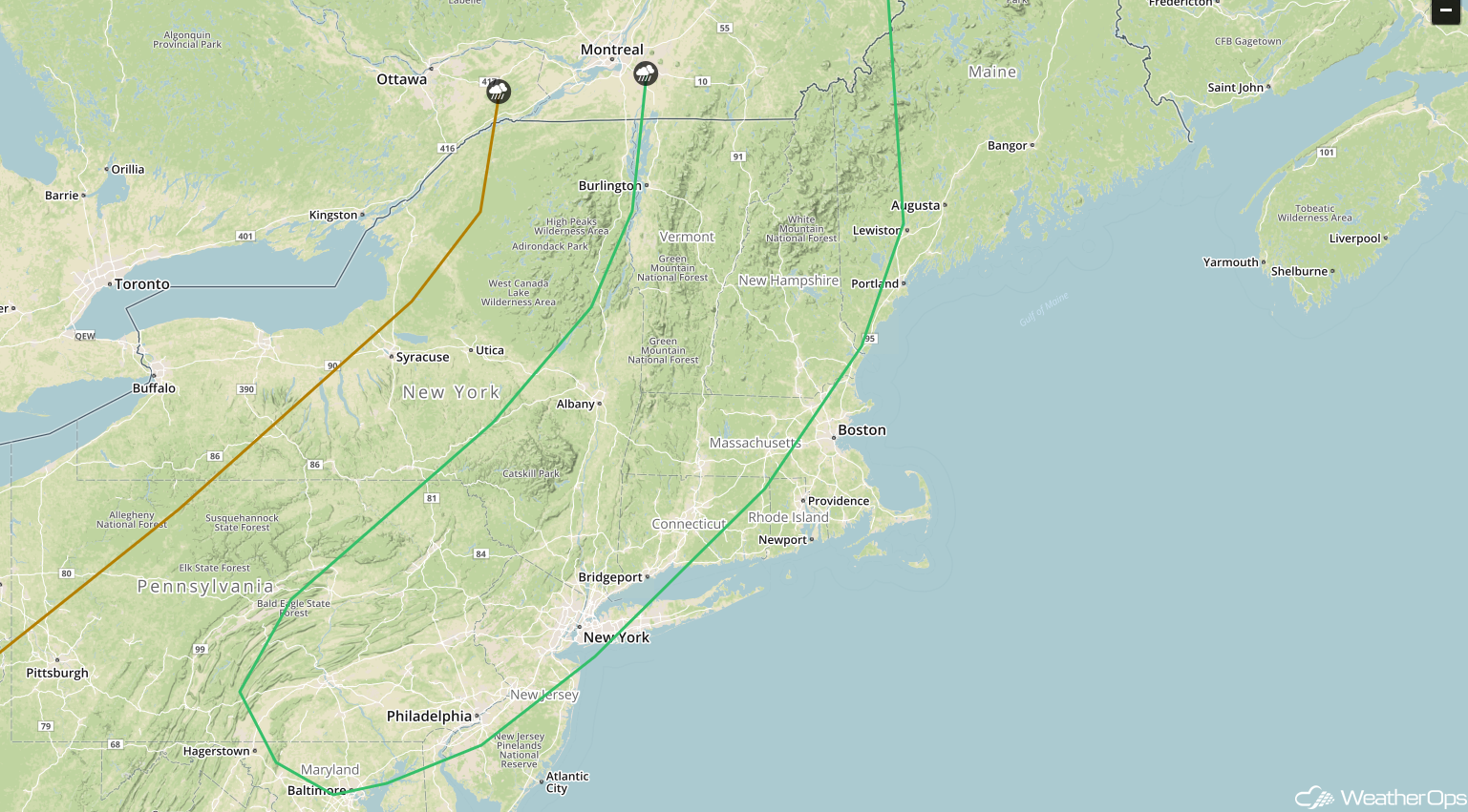
SPC Convective Outlook for Tuesday
Excessive Rainfall Tuesday for the Eastern Seaboard
There will be a potential for excessive rainfall along the Eastern Seaboard on Tuesday as the cold front described above moves eastward. Rainfall accumulations in excess of an inch are forecast from the coastal Carolinas though Maine. This will lead to a risk for local runoff and isolated flash flooding.
Major Cities in Region: Wilmington, NC, Baltimore, MD, Philadelphia, PA, New York, NY, Boston, MA, Portland, ME
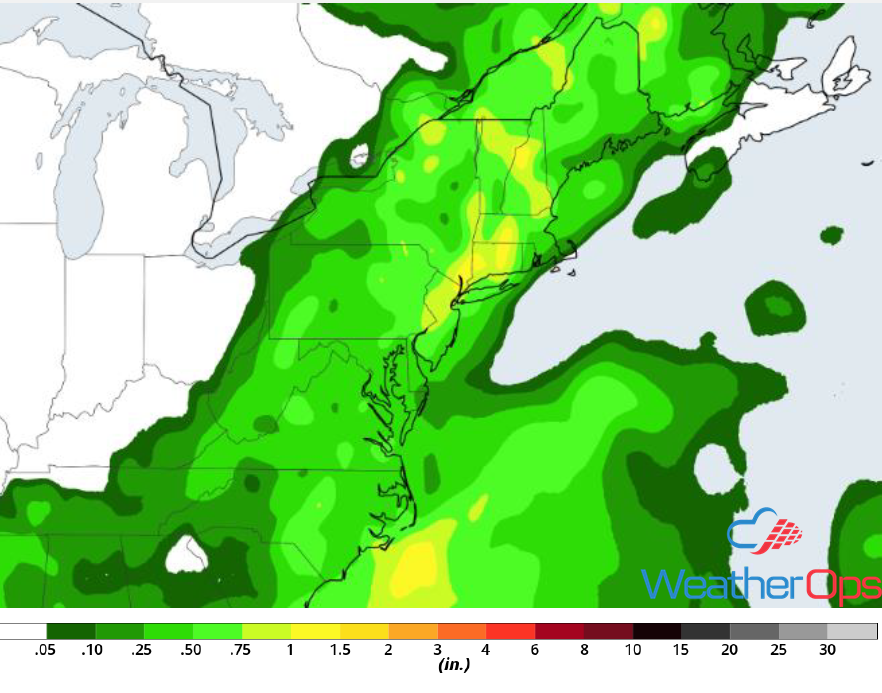
Rainfall Accumulation for Tuesday
Potential for Thunderstorms across the Central Plains on Wednesday
Thunderstorms may develop across portion of the Central Plains on Wednesday as a weak area of low pressure develops. The low will move eastward during the day with scattered thunderstorms developing near and south of the low. Strong and damaging winds, as well as large hail, will be the primary hazards with these storms.
Major Cities in Region: Pierre, SD, Sioux Falls, SD, Sioux City, IA, Omaha, NE
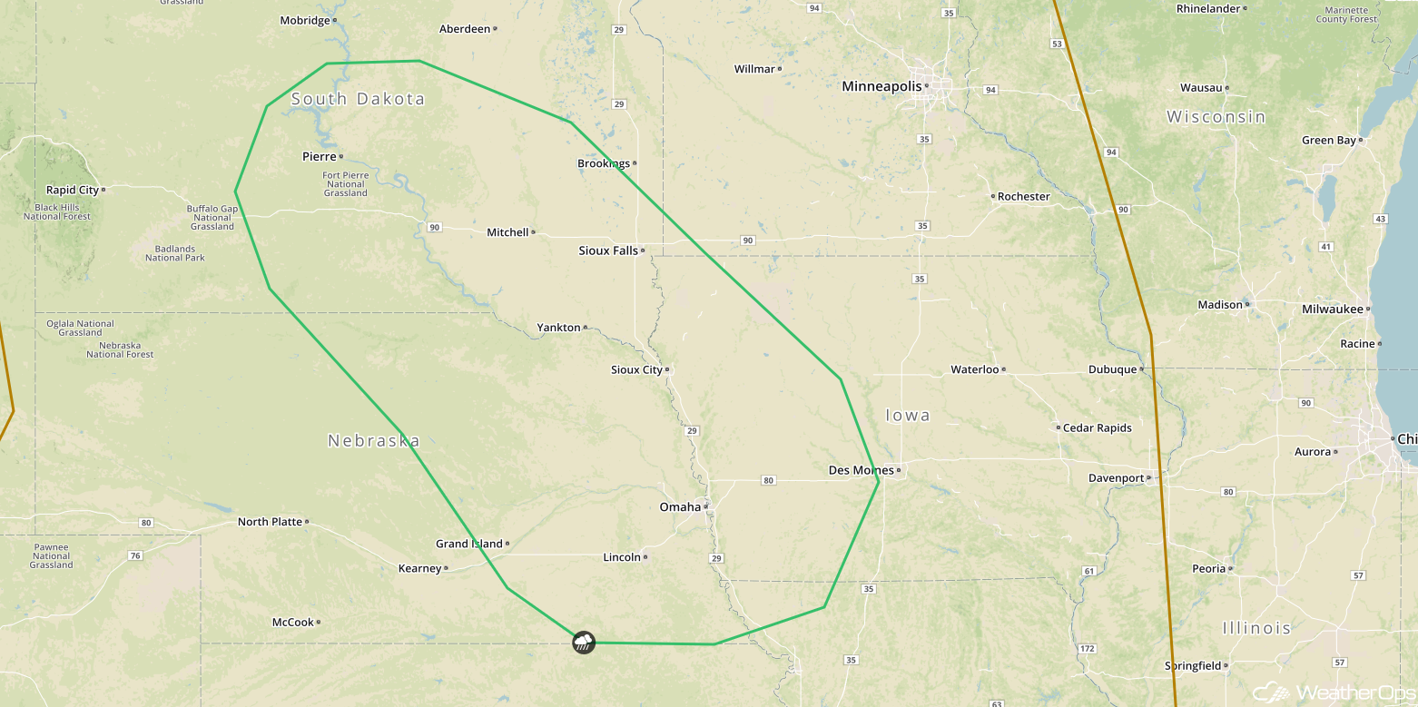
SPC Convective Outlook for Wednesday
A Look Ahead
Showers and thunderstorms may develop across portions of the Upper Midwest on Thursday as an area of low pressure moves eastward over the region. The potential for showers and thunderstorms will shift eastward into the Great Lakes on Friday. Shower activity will continue across the Great Lakes on Saturday and extend southward into the Ohio Valley. Late Saturday, an area of low pressure will develop off the East Coast and move northward. This low may bring heavy rain to portions of the Mid Atlantic and Northeast on Sunday.
