National Weather Summary for Monday, January 22, 2018
by David Moran, on Jan 22, 2018 11:01:59 AM
Snow will continue for portions of the Plains into the Great Lakes through Tuesday morning on the back of an area of low pressure. Snow and freezing rain is expected through Tuesday for portions of the Northeast as a warm front lifts northward. Thunderstorms will continue for portions of the Southeast ahead of a cold front. An upper level low moving across the Midwest will bring a potential for thunderstorms across portions of Illinois.
- Snow Continuing for Portions of the Plains and Great Lakes through early Tuesday Morning
- Snow and Freezing Rain for the Northeast through Tuesday
- Thunderstorms Continuing Monday across the Southeast
- Potential for Thunderstorms for Portions of Illinois on Tuesday
- Elevated Winds and Seas through Tuesday Evening for Gulf of Mexico
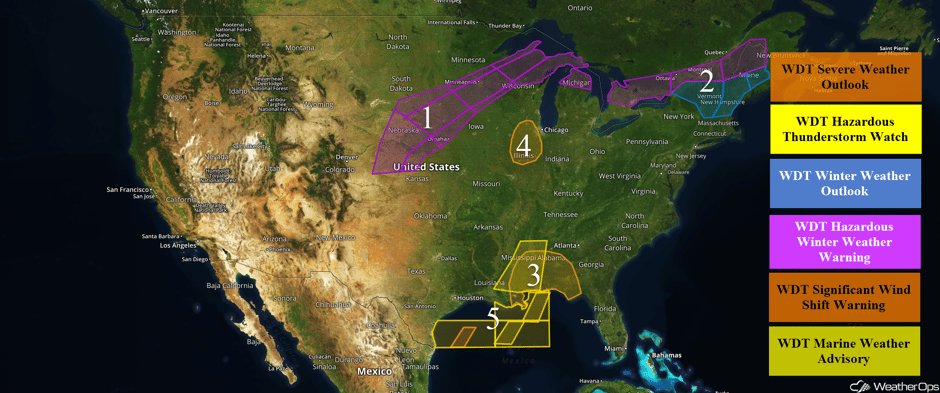 US Hazards
Snow Continuing for Portions of the Plains and Great Lakes through early Tuesday Morning
Snow will continue for portions of the Plains into the Great Lakes as an area of low pressure moves eastward. From Kansas into southern and central Nebraska, snow accumulations of 8-10 inches with isolated higher amounts in excess of 14 inches are forecast. Winds in excess of 40-50 mph will allow for blowing snow and low visibilities. Further north from central Nebraska into Iowa and Minnesota, 8-12 inches of snow with locally higher amounts in excess of 15 inches are expected in addition to some light freezing rain. From central Nebraska into western Wisconsin, snow accumulations of 2-5 inches with locally heavier amounts in excess of 8 inches are forecast. In addition, ice accumulations up to a tenth of an inch are expected. Across northern portions of Wisconsin and Michigan, 8-12 inches of snow with locally higher amounts in excess of 15 inches are expected. Winds gusting up to 40 mph will allow for near zero visibilities. Across northern portions of the lower Peninsula of Michigan, snowfall amounts of 2-5 inches with locally higher amounts in excess of 7 inches are expected. Freezing rain accumulations up to a tenth of an inch are also forecast.
Major Cities in Region: North Platte, NE, Sioux Falls, SD, Omaha, NE, Minneapolis, MN, Marquette, MI
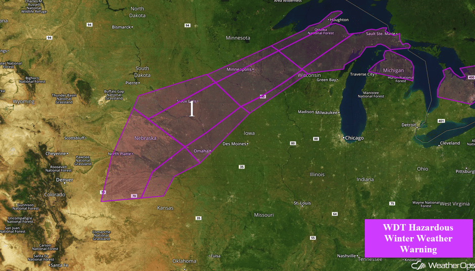 Region 1
Snow and Freezing Rain for the Northeast through Tuesday
A warm front will lift northward across the region through Tuesday afternoon, bringing the potential for light freezing rain and snow. For portions of northern New York and Vermont, up to an inch of snow and ice accumulations ranging 0.05-0.15 inch are forecast. From New Hampshire into southern Maine, snow accumulations of 1-3 inches of snow with locally higher amounts in excess of 4 inches are expected, in addition to freezing rain accumulations ranging 0.10-0.20 inch. Across northern Maine, snow accumulations of 7-12 inches with locally higher amounts in excess of 15 inches are expected. Ice accumulations will range 0.15-0.30 inch.
Major Cities in Region: Burlington, VT, Portland, ME, Augusta, ME, Bangor, ME, Caribou, ME
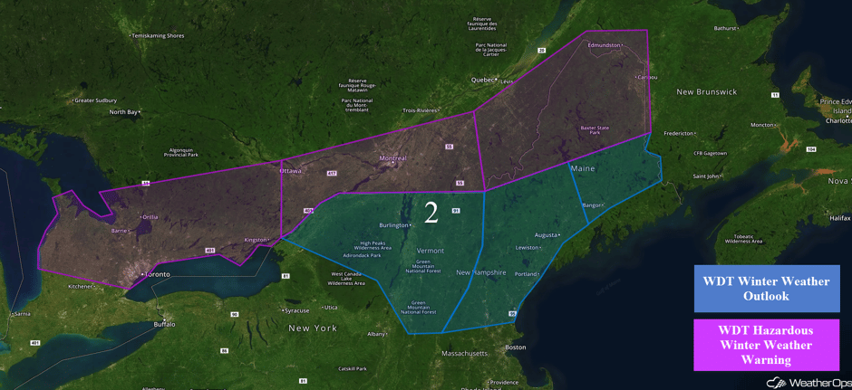 Region 2
Thunderstorms Continuing Monday across the Southeast
An upper level low is moving over the middle Mississippi Valley and the associated surface low is pushing a cold front through the region. Warm moist air is moving northward ahead of the front, and showers and thunderstorms are ongoing along the front. Although most of the forcing is to the north, conditions are favorable for the development of severe thunderstorms, especially this afternoon into tonight. Damaging winds will be the primary hazard, but an isolated tornado cannot be ruled out. The threat should end as the cold front passes.
Major Cities in Region: Baton Rouge, LA, Jackson, MS, New Orleans, LA, Montgomery, AL, Tallahassee, FL
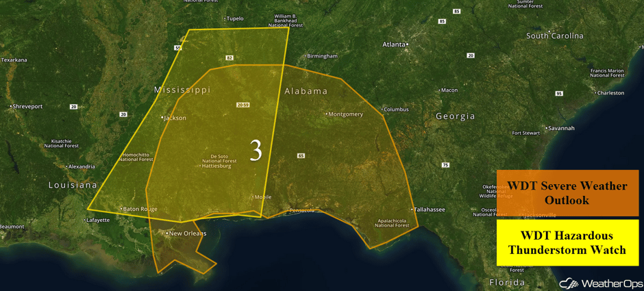 Region 3
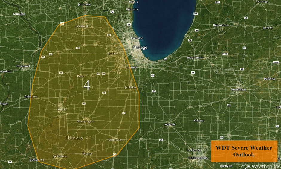
Potential for Thunderstorms for Portions of Illinois on Tuesday
An upper level low will be moving over the region today, bringing in some colder air aloft and favorable winds for the development of severe thunderstorms. An area of low pressure will develop to the north and its associated cold front should move through the area this evening and tonight. Enough instability may develop during daytime heating for the development of isolated severe thunderstorms. Damaging winds will be the primary hazard, but an isolated tornado or two cannot be ruled out. Storms should develop by mid to late afternoon and should end during the evening hours as the moisture moves eastward.
Major Cities in Region: Springfield, IL
 Region 4
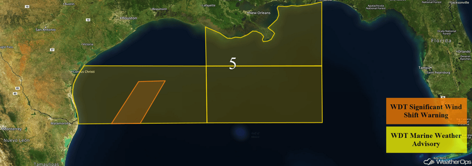
Elevated Winds and Seas through Tuesday Evening for Gulf of Mexico
Winds and seas will increase across the Gulf of Mexico through Tuesday evening as a cold front moves through the region. Across western portions of the region, winds will become northerly at 20-25 knots with gusts 30-35 knots. Swells will build to 5-7 feet in the deeper waters and 2-4 feet near the shore. For eastern areas, winds will shift from the southwest to the northwest at 15-20 knots before increasing to 20-30 knots with gusts in excess of 30 knots after midnight. Seas of 5-8 feet are expected.
 Region 5
A Look Ahead
Moderate to heavy snow may develop across the Northern Rockies on Thursday as an area of low pressure develops. Some light snow may continue into Friday. Elsewhere, quiet weather is expected.
This is just a brief look at current weather hazards. We can provide you site-specific weather forecast information to protect your staff and assets and to assess your weather risk. Try a 7-day demo right away and learn how timely precision weather information can enhance your bottom line.


