


by David Moran, on Feb 18, 2019 10:37:01 AM
An area of low pressure will continue to produce snow across the Four Corners region through Tuesday. Elevated winds and seas will continue through Tuesday afternoon for portions of the Gulf of Mexico as a cold front moves eastward.
- Snow for the Four Corners through Tuesday
- Elevated Winds and Seas through Tuesday Afternoon across the Gulf of Mexico
- Thunderstorms from the Lower Mississippi Valley into the Ohio River Valley Tuesday and Wednesday
- Excessive Rainfall Tuesday and Wednesday from the Lower Mississippi Valley into the Lower Ohio Valley
- Freezing Rain and Snow for the Central and Southern Plains on Tuesday
- Snow Wednesday across the Upper Midwest
- Potential for Freezing Rain and Snow from the Mid Atlantic into the Northeast on Wednesday
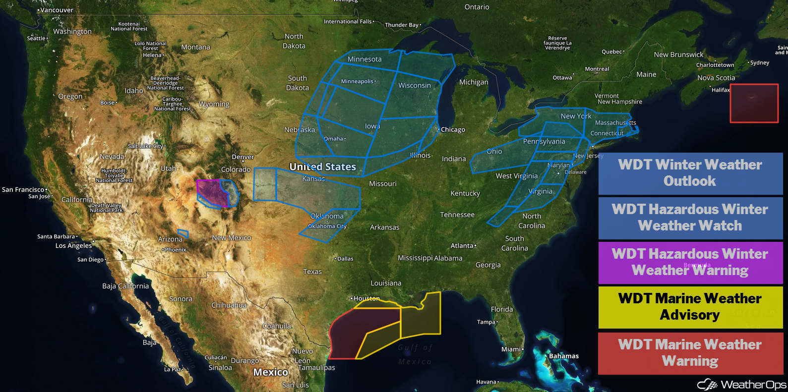
US Hazards
Snow for the Four Corners through Tuesday
An area of low pressure is forecast to intensify over the region and progress eastward slowly today into tomorrow. As this occurs, moderate to heavy snow already falling across portions of Arizona will spread into Colorado. Snowfall totals will range 4-8 inches with locally higher amounts in excess of a foot.
Major Cities in Region: Flagstaff, AZ, Durango, CO, Alamosa, CO
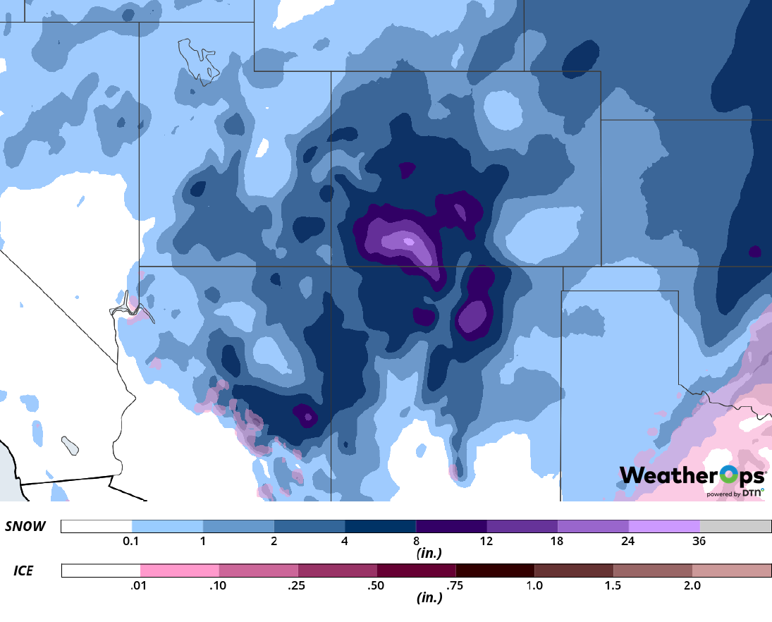
Snow Accumulation through Saturday
Elevated Winds and Seas through Tuesday Afternoon across the Gulf of Mexico
A cold front moving across the Gulf of Mexico will produce elevated winds and seas through Tuesday afternoon. Ahead of the front, winds will be south-southeasterly to southerly at 12-17 knots. Behind the front, winds will be northeasterly to north-northeasterly at 25-30 knots. Seas will be 7-12 feet in the deeper waters and 5-9 feet near the shore.
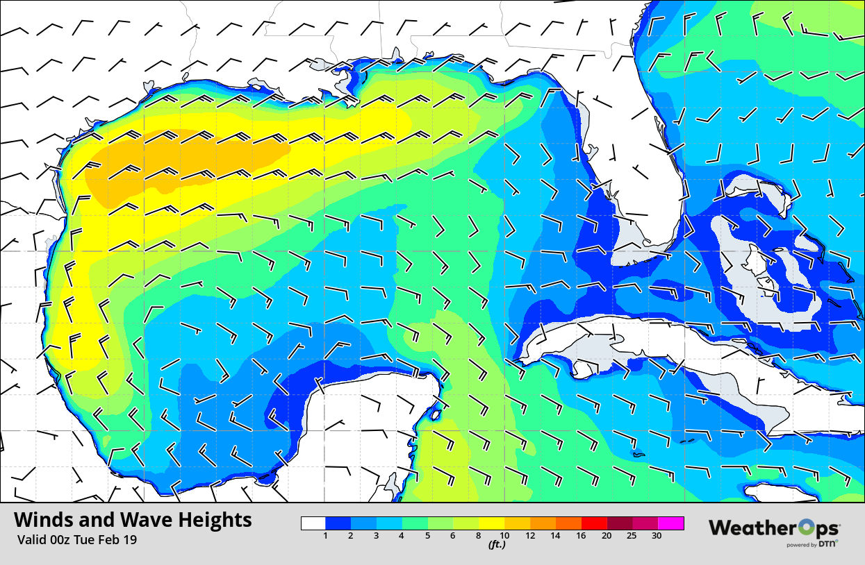
Winds and Wave Heights 6pm CST Monday
Thunderstorms from the Lower Mississippi Valley into the Ohio River Valley Tuesday and Wednesday
An area of low pressure is forecast to develop over the Gulf of Mexico Monday evening into Tuesday. By sunrise on Tuesday, the associated warm front will have reached the Gulf Coast, allowing shower and thunderstorm activity to develop and expand northward. As the day progresses, daytime heating and rich moisture being brought northward from the Gulf of Mexico will allow this activity to intensify. Gusty winds and isolated tornadoes will be the primary hazards with these storms. The low will move ashore by Wednesday. Thunderstorms are expected to begin to develop along the associated cold front, allowing for a line of thunderstorms to slowly progress eastward across the region. Severe winds and hail will be the primary hazards with the storms on Wednesday.
Major Cities in Region: Baton Rouge, LA, Memphis, TN, Jackson, MS, Evansville, IN, Louisville, KY, Cincinnati, OH
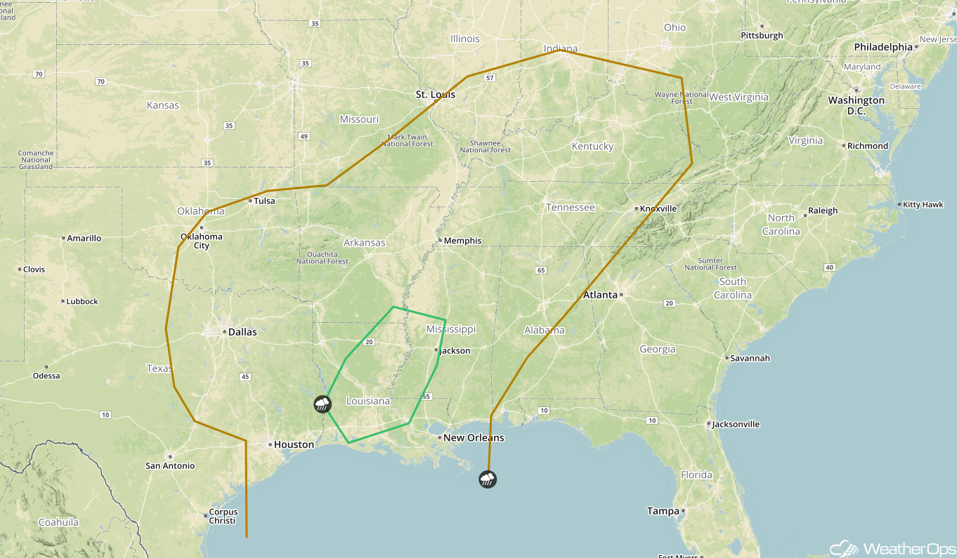
SPC Convective Outlook for Tuesday
Excessive Rainfall Tuesday and Wednesday from the Lower Mississippi Valley into the Lower Ohio Valley
In addition to the severe weather potential described above, there will be the potential for excessive rainfall. Two day rainfall accumulations of 3-5 inches with locally higher amounts in excess of 6 inches are expected. This may result in flooding and flash flooding.
Major Cities in Region: Baton Rouge, LA, Memphis, TN, Jackson, MS, Nashville, TN, Louisville, KY
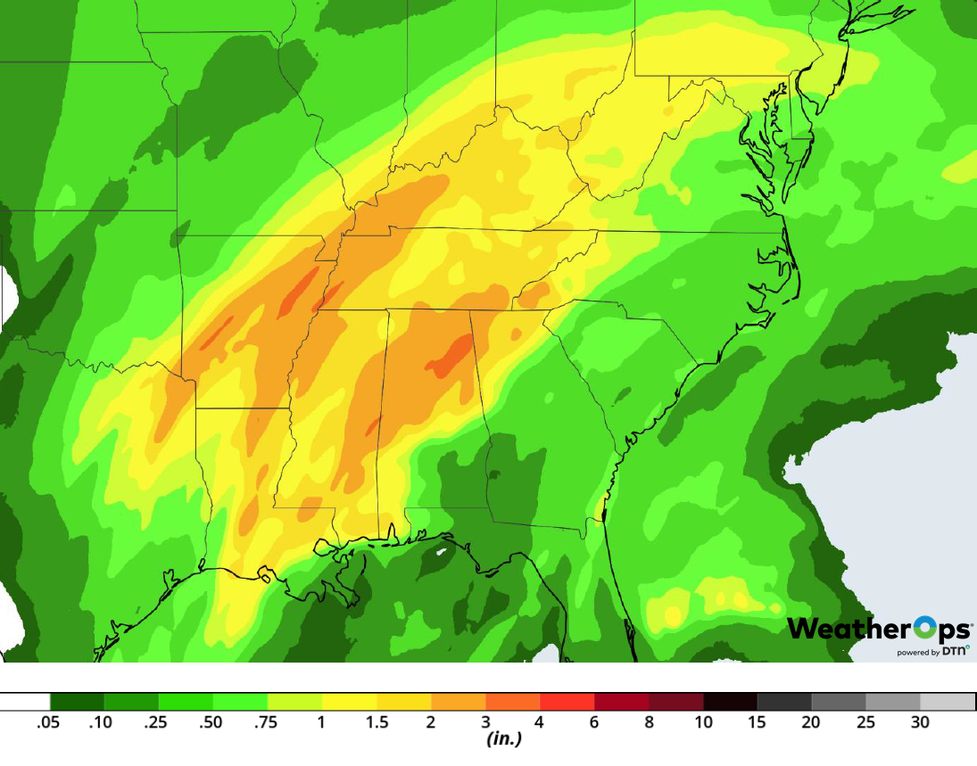
Rainfall Accumulation for Tuesday and Wednesday
Freezing Rain and Snow for the Central and Southern Plains on Tuesday
Multiple systems are forecast to move over the Central and Southern Plains on Tuesday. The first low, currently over the Four Corners region, will move eastward while a second system is forecast to intensify over the Gulf of Mexico as it lifts northward. These two systems will produce moderate to heavy snowfall to the north and a wintry mix of precipitation to the south. Snowfall amounts of 3-5 inches of snow are likely across eastern Nebraska, central Kansas, and northern Oklahoma. Further south, accumulations will range from a dusting to an inch. Warmer temperatures further south will allow for rain, sleet and freezing rain along and south of Interstate 44. Ice accumulations will range 0.10-0.25 inch.
Major Cities in Region: North Platte, NE, Wichita, KS, Oklahoma City, OK, Tulsa, OK, Omaha, NE, Kansas City, MO, Des Moines, IA, Columbia, MO
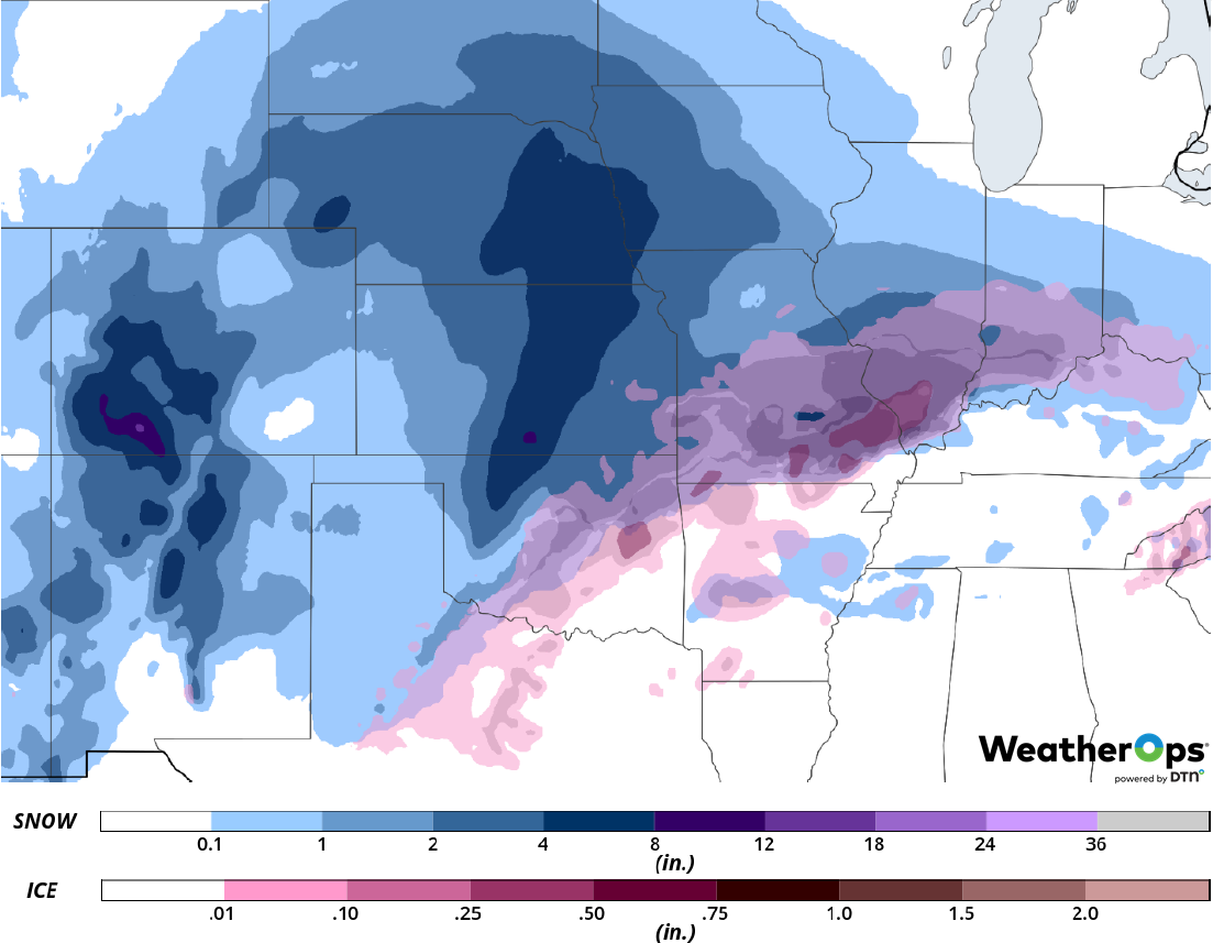
Snow and Ice Accumulation for Tuesday
Snow Wednesday across the Upper Midwest
Moderate to heavy snowfall is expected across the Upper Midwest on Wednesday as the low described above continues to move eastward. Snowfall totals will range 4-6 inches with locally higher amounts in excess of 8 inches, particularly across southern Minnesota.
Major Cities in Region: Grand Forks, ND, Sioux Falls, SD, Omaha, NE, Des Moines, IA, Minneapolis, MN, Duluth, MN, Green Bay, WI
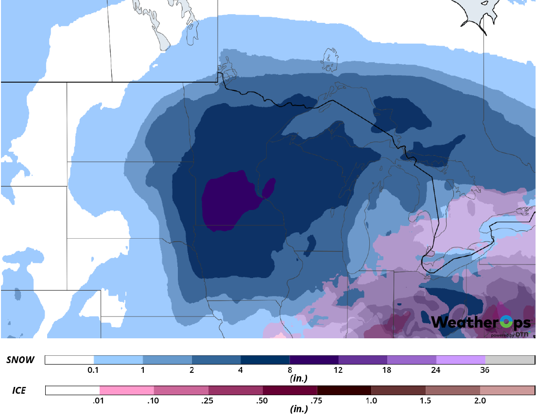
Snow Accumulation for Wednesday
Potential for Freezing Rain and Snow from the Mid Atlantic into the Northeast on Wednesday
The low developing across the Gulf of Mexico described above will continue to move eastward on Wednesday, bringing moisture northward. With cold air in place, snow, sleet, and freezing rain are expected. Due to the uncertainty in the track of the low, there still remains some uncertainty in exact snow and ice accumulations. Snowfall amounts of 3-5 inches are forecast; ice accumulations of 0.10-0.30 inch are expected. Hazardous travel and power outages are expected in areas receiving ice accumulations more than 0.25 inch.
Major Cities in Region: Pittsburgh, PA, Buffalo, NY, Albany, NY, Philadelphia, PA, New York, NY, Boston, MA
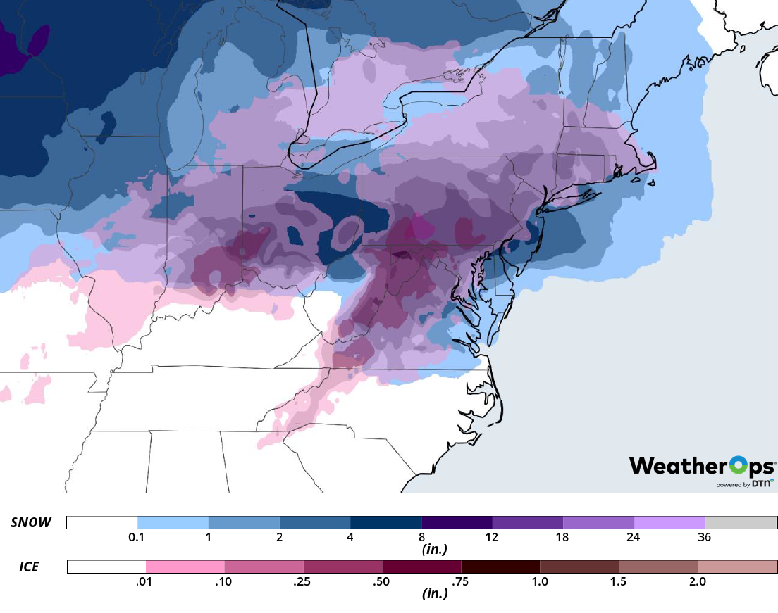
Snow and Ice Accumulation for Wednesday
A Look Ahead
Freezing rain and snow will continue across the Northeast on Thursday as the area of low pressure described above moves eastward. Snow may develop across the Northern Plains and Upper Midwest on Friday. Going into the weekend, freezing rain and snow are expected Saturday across the Great Lakes as an area of low pressure moves into the region. Snow may develop across portions of the Plains. Heavy snow are forecast from the Plains into the Great Lakes on Sunday.
