National Weather Summary for Monday, August 22, 2016
by David Moran, on Aug 22, 2016 11:11:00 AM
No WeatherOps hazards are in effect for today, however, lingering showers will be possible across the Northeast on Monday as a cold front pushes offshore. Across the Northern Plains, an area of low pressure will develop on Tuesday, allowing for the development of strong to severe thunderstorms. The cold front associated with the area of low pressure moving across the Northern Plains will allow for a risk for the development of thunderstorms across the Midwest on Wednesday.

US Hazards
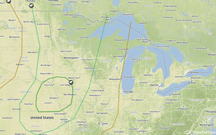
Strong to Severe Thunderstorms Possible Tuesday across Portions of the Northern and Central Plains
An area of low pressure will develop over the Northern Plains on Tuesday, allowing for the potential for the development of thunderstorms from Minnesota southward into Kansas. Thunderstorms will begin to develop during the late afternoon; large hail and damaging winds will be the primary hazards with these storms. Southward into the Midwest and Central Plains, thunderstorms will likely develop by the early afternoon and increase in coverage and intensity into the evening. Large hail, damaging winds, and an isolated tornado will be possible in the southern portion of the threat area.
In addition to the severe weather potential, excessive rainfall will be possible across southern portions of the threat region where coverage and rainfall rates will be greater as a large thunderstorm complex develops during the evening. Rainfall accumulations of 1-2 inches, with locally higher amounts in excess of 3 inches will be possible over eastern Nebraska and western Iowa.
Major Cities in Region: Fargo, ND, Sioux Falls, SD, Omaha, NE, Kansas City, MO, Des Moines, IA, Minneapolis, MN

SPC Convective Outlook for Tuesday
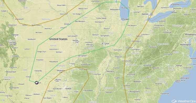
Strong to Severe Thunderstorms Possible Wednesday Across the Midwest
A cold front will continue to progress eastward across the Plains on Wednesday, allowing for the potential for thunderstorms across portions of the Great Lakes and Midwest. Due to morning showers, the overall coverage and intensity is uncertain at this time. However, the threat will likely be marginal, with the greatest threat being over Lake Michigan where damaging winds and a couple tornadoes will be possible during the late afternoon and early evening. Southward into the Midwest, additional thunderstorms will be possible during the afternoon hours with damaging winds as the primary hazard within any severe activity.
Major Cities in Region: Amarillo, TX, Wichita, KS, Kansas City, MO, Des Moines, IA, Chicago, IL

SPC Convective Outlook for Wednesday
A look at the tropics
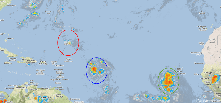
Tropical Storm Fiona (red oval) has weakened into a Tropical depression and is continuing to move toward the west-northwest. Continued west-northwest motion is expected while decreasing in forward speed through Tuesday. Gradual weakening is expected over the next 48 hours.
Further to the southeast (blue oval), shower activity is increasing in association with a tropical wave east of the Lesser Antilles. Further development is possible as this system moves toward Hispanola and the Bahamas.
A tropical depression is developing south-southwest of the Cabo Verde Islands (green oval). Further development is possible over the next 48 hours as the system continues to move westward.

Tropical Atlantic Satellite
The Look Ahead
Showers and thunderstorms are expected to develop across the Northeast ahead of a cold front on Thursday; no significant severe weather threat is currently expected. A frontal boundary will stall over the Southern Plains allowing for the development of showers and thunderstorms for Thursday and Friday. By Friday, an area of low pressure will develop over the Northern Plains on Friday, posing a risk for thunderstorms for portions of the Central and Northern Plains. Going into the weekend, an area of low pressure developing over the Central High Plains will allow for the development of showers and thunderstorms across the Northern and Central Plains.
This is just a brief look at current weather hazards. We can provide you site-specific forecast information for the purpose of protecting your personnel and assets. Try a 7-day demo right away and learn how timely precision weather information can enhance your bottom line.


