


by David Moran, on Apr 2, 2018 11:06:32 AM
Snow will continue for portions of the Mid Atlantic and Northeast through early Monday afternoon as a disturbance moves out of the region. An area of low pressure will bring snow to portions of the Northern Rockies into the Great Lakes through Wednesday morning. Thunderstorms are forecast to develop from the Ozarks into the Ohio Valley as a warm front lifts northward.
- Snow Continuing for the Mid Atlantic and Northeast through early Monday Afternoon
- Snow through Wednesday Morning from the Northern Rockies through the Great Lakes
- Thunderstorms from the Ozarks to the Ohio Valley Monday
- Potential for Thunderstorms Tuesday from Central Texas to the Southern Great Lakes
- Risk for Thunderstorms from Northern Florida to the Mid Atlantic on Wednesday
 US Hazards

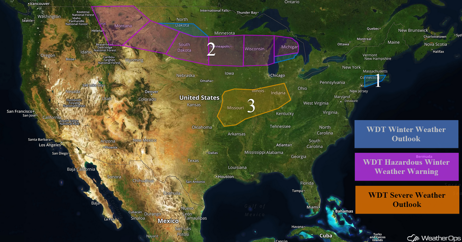
Snow Continuing for the Mid Atlantic and Northeast through early Monday Afternoon
Snow is expected to continue for portions of the Mid Atlantic and Northeast through early Monday afternoon. Additional snow accumulations of 2-4 inches are forecast, resulting in some hazardous travel conditions.
Major Cities in Region: New York City, NY, Hartford, CT, Providence, RI, Boston, MA, Portland, ME
 Snow Accumulation through Monday
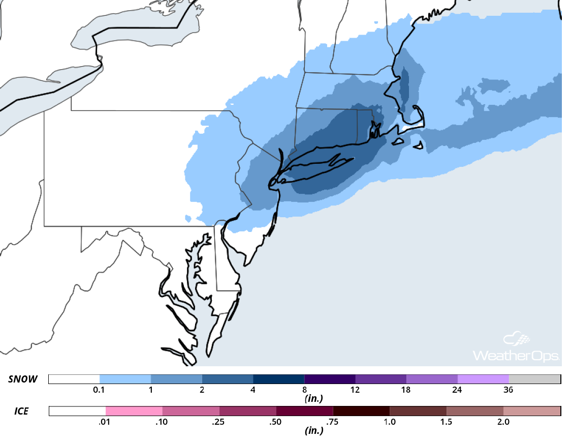
Snow through Wednesday Morning from the Northern Rockies through the Great Lakes
Snow is continuing across the Northern Rockies and adjacent High Plains this morning. This activity is expected to spread eastward across the Upper Midwest and Great Lakes through Wednesday. Moderate to heavy snow, along with light icing, is expected across the region. Across the Northern Plains, snow accumulations will range 4-8 inches with locally higher amounts in excess of 10 inches. Further east across the Great Lakes, 6-12 inches with locally higher amounts in excess of 15 inches are forecast. In addition, ice accumulations up to 0.10 inch are expected for portions of Michigan and Wisconsin. Winds gusting in excess of 25 mph will allow for blowing snow and low visibilities.
Major Cities in Region: Helena, MT, Great Falls, MT, Bismarck, ND, Pierre, SD, Sioux Falls, SD, Minneapolis, MN, Green Bay, WI, Milwaukee, WI, Traverse City, MI
 Snowfall Accumulation through Wednesday
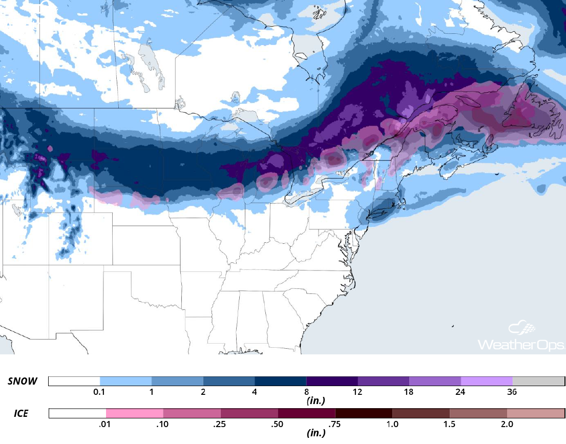
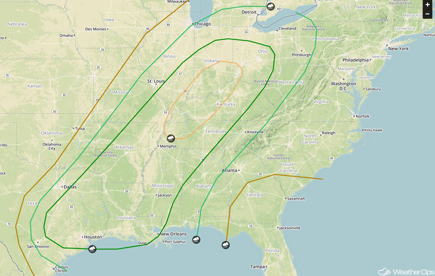
Thunderstorms from the Ozarks to the Ohio Valley Monday
Thunderstorms may develop across the Ozarks and into the Ohio Valley on Monday as a warm front associated with an area of low pressure developing over the Central Rockies lifts northward. Activity is expected to develop during the afternoon and evening across the Ozarks and then lift northeastward. Large hail will be the primary hazard with these storms.
Major Cities in Region: Joplin, MO, Springfield, MO, Columbia, MO, St. Louis, MO, Evansville, IN, Indianapolis, IN, Cincinnati, OH
 Thunderstorm Potential for Monday
Potential for Thunderstorms Tuesday from Central Texas to the Southern Great Lakes
There will be an enhanced risk of severe thunderstorms from the Plains into the southern Great Lakes on Tuesday as an intensifying area of low pressure and associated cold front move eastward. Thunderstorms are forecast to develop during the afternoon and evening, potentially continuing into the overnight hours before weakening. Isolated supercells may develop ahead of the line. Large hail, damaging winds, and tornadoes will all be potential hazards with these storms. The highest threat will likely be centered over the western Ohio Valley region.
Major Cities in Region: Austin, TX, Houston, TX, Shreveport, LA, New Orleans, LA, Memphis, TN, Jackson, MS, Evansville, IN, Louisville, KY, Cincinnati, OH, Columbus, OH
 SPC Convective Outlook for Tuesday
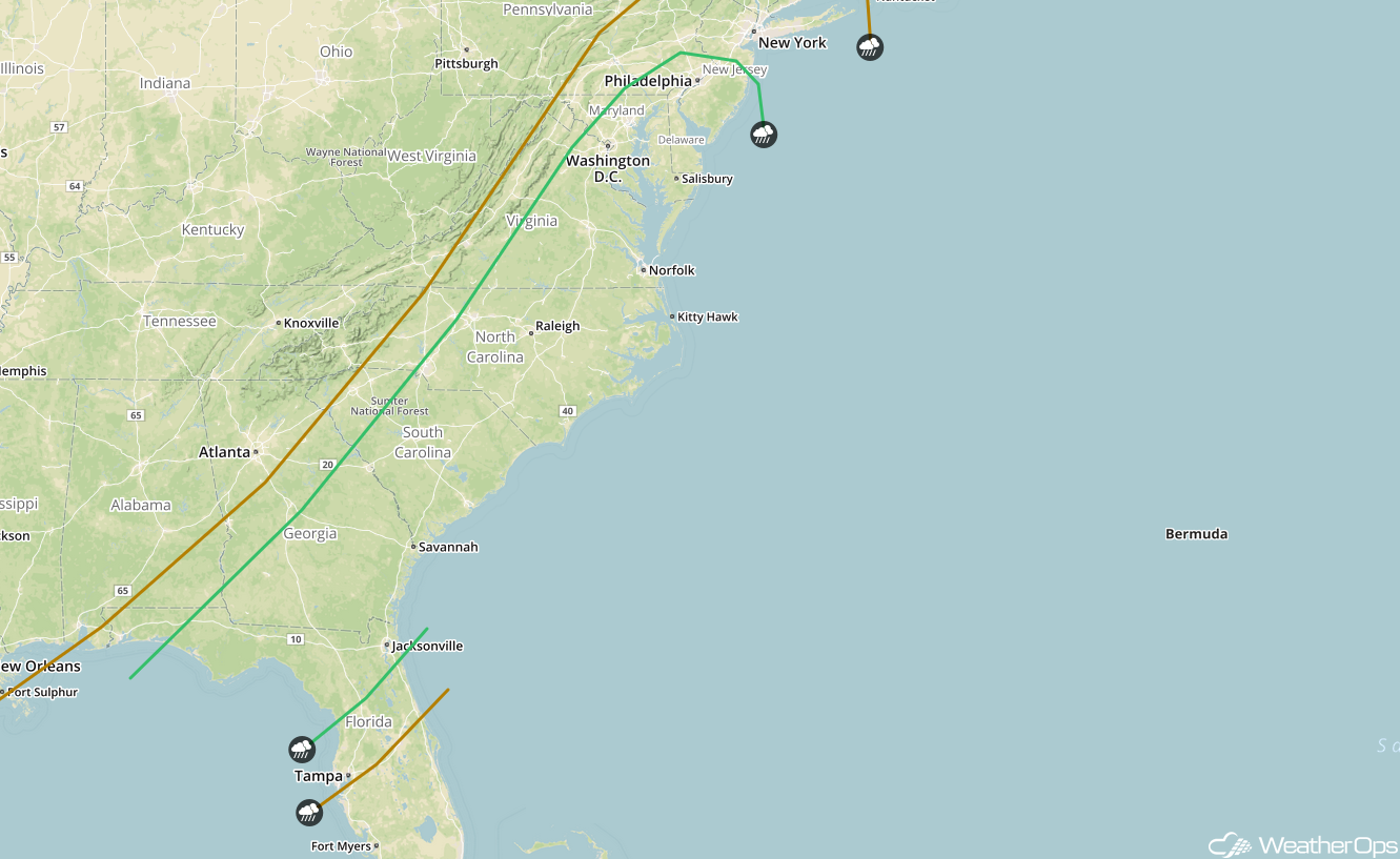
Risk for Thunderstorms from Northern Florida to the Mid Atlantic on Wednesday
Thunderstorms are forecast to be ongoing during the morning hours from the Mid Atlantic southward into Northern Florida on Wednesday ahead of a fast moving cold front. An approaching upper level disturbance combined with favorable wind shear may allow for a marginal risk of strong to severe thunderstorms. Damaging winds will be the primary hazard with these storms. The threat should mostly end by midday as the front moves offshore.
Major Cities in Region: Tallahassee, FL, Jacksonville, FL, Savannah, GA, Charleston, SC, Charlotte, NC, Raleigh, NC, Washington, DC, Philadelphia, PA
 SPC Convective Outlook for Wednesday
A Look Ahead
Light to moderate snow may develop across portions of the Northeast on Friday as an area of low pressure moves through the region. On Sunday, an area of low pressure may develop over portions of the Plains, bringing snow to portions of the Dakotas and Minnesota.
This is just a brief look at current weather hazards. We can provide you site-specific weather forecast information for the purpose of protecting your personnel and assets and to assess your weather risk. Try a 7-day demo right away and learn how timely precision weather information can enhance your bottom line.
