by David Moran, on Sep 7, 2018 11:41:06 AM
Heavy to excessive rainfall will continue through Saturday across the Ozarks and Mid Mississippi Valley as tropical moisture continues to move northeastward. A stalled front will continue to produce heavy rain across portions of Texas through Sunday. Excessive rainfall is forecast across portions of the East Coast on Friday ahead of a cold front. Thunderstorms may develop across portions of North Dakota as an area of low pressure intensifies.
- Excessive Rainfall for the Ozarks and Mid Mississippi Valley through Saturday
- Risk for Excessive Rainfall through Sunday across Texas
- Potential for Excessive Rainfall for Portions of the East Coast Friday
- Thunderstorms Friday across North Dakota
- Risk for Thunderstorms across the Northern High Plains on Saturday
- Excessive Rainfall Saturday and Sunday for the Ohio River Valley
- Tropical Update
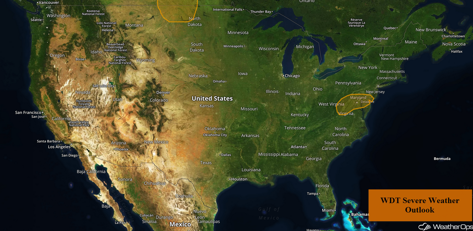 US Hazards
Excessive Rainfall for the Ozarks and Mid Mississippi Valley through Saturday
Rich tropical moisture and a stalled front over the Ozarks and Mid Mississippi Valley will allow heavy to excessive rainfall to continue through Saturday. While the heavier totals will be across Missouri and Illinois, heavy rainfall will continue over northeast Arkansas. Total rainfall accumulations of 1.50-3.00 inches with locally higher amounts in excess of 5 inches are forecast, especially across eastern Missouri. Additional accumulations of 0.75-1.00 inch are expected on Saturday, leading to a risk for flooding and flash flooding.
Major Cities in Region: Kirksville, MO, St. Louis, MO, Jonesboro, AR, Springfield, IL
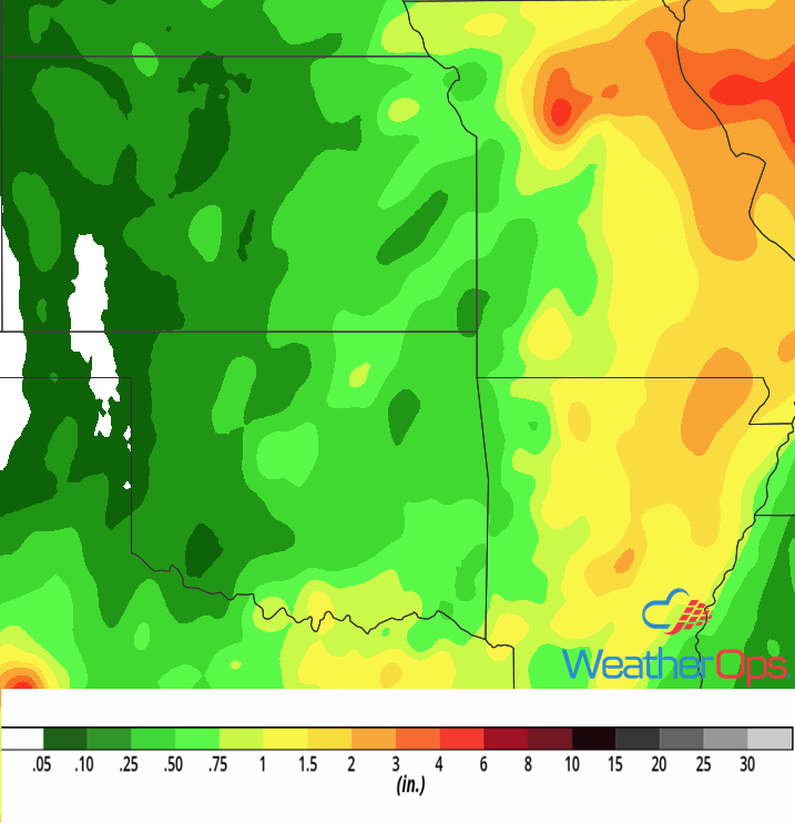
Rainfall Accumulation through Saturday
Risk for Excessive Rainfall through Sunday across Texas
A slow moving front, combined with increased tropical moisture due to southeasterly flow, will lead to the potential for heavy to excessive rainfall through Sunday. The heaviest rainfall will be along the front as it slowly moves eastward. Each day, rainfall accumulations of 0.50-1.00 inches with locally higher amounts in excess of 1.50 inches are expected. Three day rainfall accumulations will range 1.50-3.00 inches with locally heavier amounts in excess of 4 inches.
Major Cities in Region: Midland, TX, Lubbock, TX, Del Rio, TX, San Antonio, TX, Austin, TX, Tyler, TX
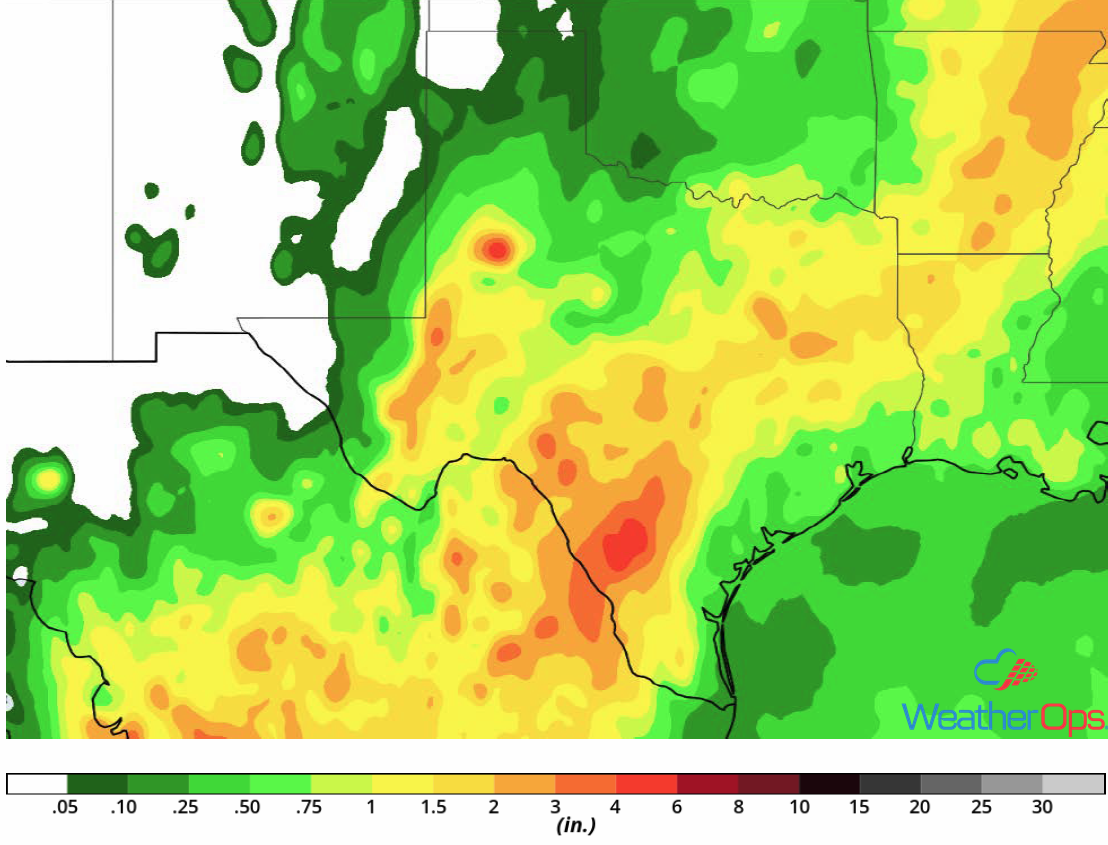
Rainfall Accumulation through Sunday
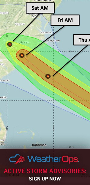
Potential for Excessive Rainfall for Portions of the East Coast Friday
Heavy to excessive rainfall is expected along portions of the East Coast ahead of a stalled front. Rainfall accumulations will range 0.50-1.00 inch with locally higher amounts in excess of 1.25 inches.
Major Cities in Region: Atlantic City, NJ, New York, NY
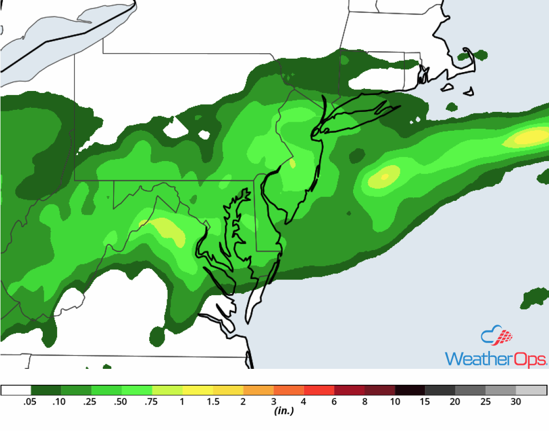
Rainfall Accumulation for Friday
Thunderstorms Friday across North Dakota
Scattered strong to severe thunderstorms are forecast across portions of North Dakota as an area of low pressure develops and plentiful moisture remains in place. Strong winds and large hail will be the primary hazards with these storms.
Major Cities in Region: Minot, ND
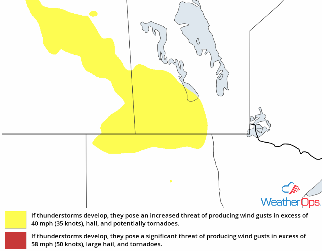
Thunderstorm Risk for Friday
Risk for Thunderstorms across the Northern High Plains on Saturday
A shortwave trough is forecast to progress eastward over the Rockies Saturday afternoon. At the surface, a lee trough is forecast to develop. With daytime heating, plentiful moisture, and forcing from the trough, isolated strong to severe thunderstorms are expected to develop. Strong winds and large hail will be the primary hazards with the stronger storms.
Major Cities in Region: Gillette, WY, Rapid City, SD, Minot, ND
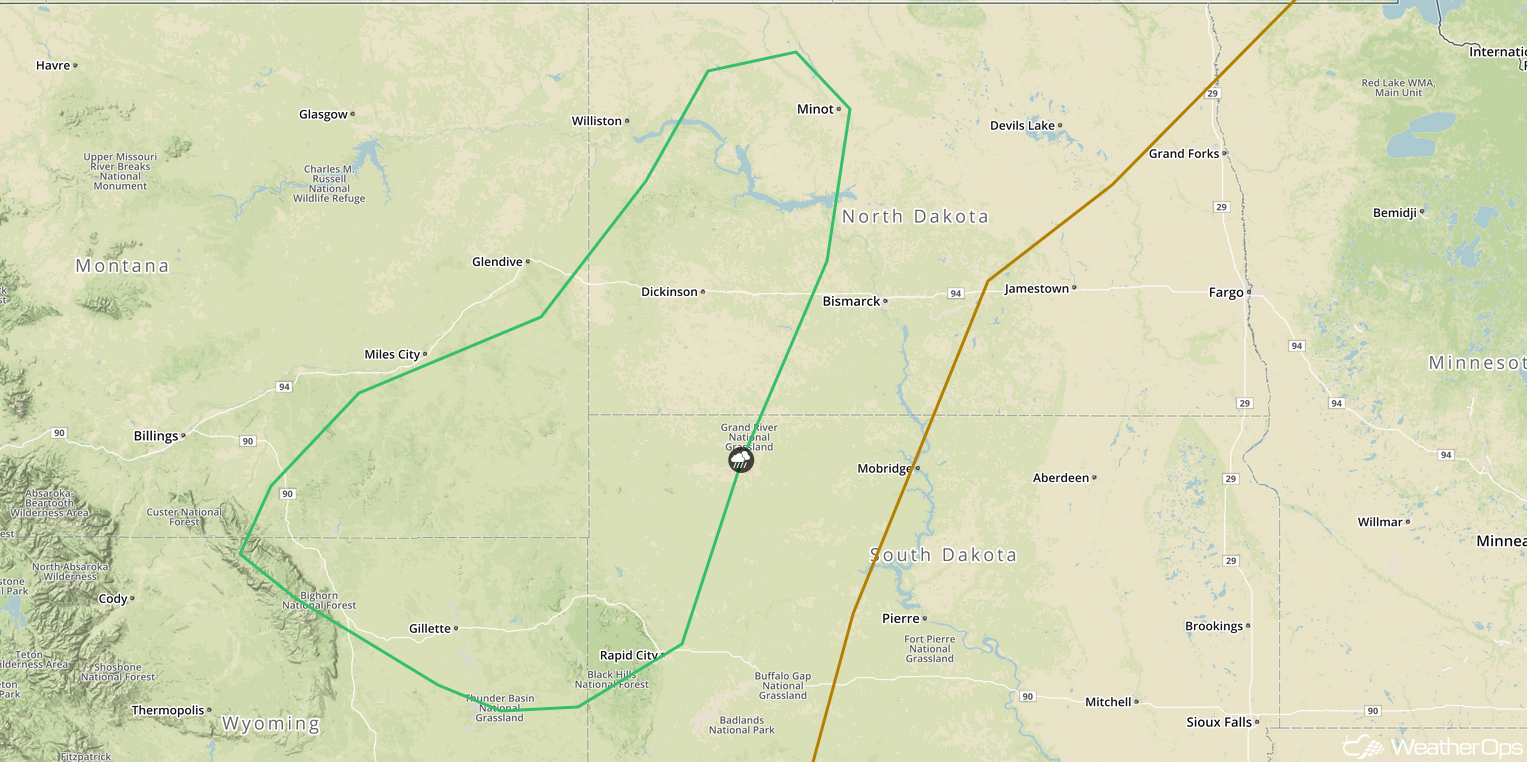
SPC Convective Outlook For Saturday
Excessive Rainfall Saturday and Sunday for the Ohio River Valley
Tropical moisture associated with the remnants of Gordon is forecast to lift to the northeast over the Ohio River Valley this weekend along a stalled front. Due to the increased moisture and the stalled front in place, excessive rainfall is expected Saturday and Sunday. Total rainfall accumulations on Saturday will range 2-4 inches with locally higher amounts in excess of 6 inches. The heaviest rainfall will be across central Indiana. On Sunday, an additional 2-4 inches with locally higher amounts is expected; the heaviest rain will likely be across northeastern Ohio and western Pennsylvania. This will lead to a potential for flooding and flash flooding.
Major Cities in Region: Springfield, IL, Indianapolis, IN, Columbus, OH, Cleveland. OH, Pittsburgh, PA
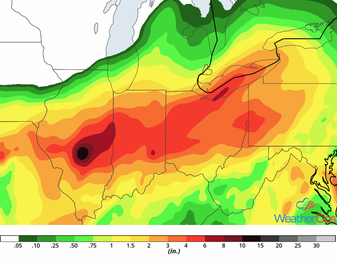
Rainfall Accumulation for Saturday and Sunday
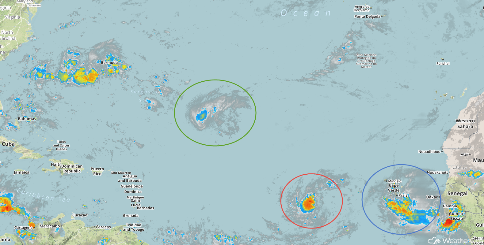
Tropical Update
Tropical Storm Florence (green oval) is 935 miles east-southeast of Bermuda and is moving westward at 8 mph. This general motion is expected to continue through Sunday and a west-northwestward motion with an increase in forward speed is expected early next week. Maximum sustained winds at near 65 mph with higher gusts. Restrengthening is expected over the weekend. Florence is expected to become a hurricane again by Saturday night or Sunday.
Potential Tropical Cyclone Eight (red oval) is 460 miles east-southeast of the Cabo Verde Islands and is moving westward at 10 mph. This general motion is expected to continue through the weekend with a gradual increase in forward speed. On the forecast track, the disturbance is expected to move near the southern Cabo Verde Islands on Sunday. Maximum sustained winds are near 35 mph with higher gusts. The system is expected to become a tropical depression or tropical storm later today.
An area of low pressure located 650 miles west of the Cabo Verde Islands (blue oval) is gradually becoming better defined. In addition, the associated showers and thunderstorms remain fairly concentrated near the center. This system is expected to become a tropical depression today or tonight while it slowly moves westward.
Enhanced Infrared Satellite
A Look Ahead
As tropical moisture continues to move northeastward on Monday, heavy rainfall is expected across portions of the Northeast. Rainfall totals of 2-4 inches with locally higher amounts in excess of 5 inches are expected. Heavy rainfall may continue across portions of Vermont, New Hampshire, and Maine on Tuesday. A few thunderstorms may develop across the Northern Plains Wednesday along a cold front. Florence may approach the East Coast on Wednesday. Areas along the East Coast may receive heavy rain on Thursday in association with Florence, depending on the track.