National Weather Summary for Friday, September 2, 2016
by David Moran, on Sep 2, 2016 11:30:02 AM
Tropical Storm Hermine will continue to move across the southeastern US, bringing the potential for heavy rain, strong winds, and tornadoes to the region. Strong surface heating across the Central High Plains will allow for the development of thunderstorms ahead of a cold front. Hermine will continue to move along the east coast on Saturday, bringing heavy rain, strong winds, and the potential for tornadoes to portions of North Carolina and Virginia. Thunderstorms will be possible across the Central High Plains on Saturday, as a result of daytime heating. Across North Dakota, thunderstorms may develop ahead of a cold front. Additional thunderstorms are likely across the Northern Plains on Sunday. Heavy rain may be possible across portions of western Montana ahead of a cold front.
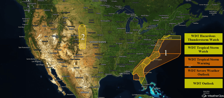
US Hazards
Region 1
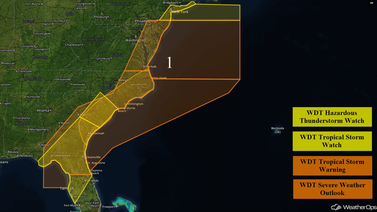
Tropical Storm Hermine made landfall this morning in the Florida Big Bend region. While Hermine is forecast to continue weakening as it moves inland, tropical storm conditions will remain likely over a large region extending from northern Florida, through Southern Georgia and eastern South Carolina, and into eastern North Carolina. Sustained winds of 45-55 mph with gusts in excess of 60 mph will be possible in the stronger squalls. Widespread rainfall accumulations of 4-8 inches, with locally higher amounts in excess of 12 inches, will be possible. Along the Gulf Coast of Florida, storm surge of over six feet will be likely with storm surge in excess of three feet expected along the coasts of Georgia and the Carolinas. A few tornadoes will also be possible. Conditions should improve across Florida through the morning and into the afternoon. Tropical storm conditions will spread into South Carolina by Friday afternoon, and into North Carolina by Friday evening. These tropical storm conditions will end from south to north, ending across North Carolina by Saturday afternoon.
Hermine will continue to move northeastward on Saturday, affecting the Mid Atlantic and Northeast. Sustained winds of 50-60 mph with gusts in excess of 70 mph will be possible. Seas in excess of 12 feet and waterspouts will also be possible. These conditions could persist as late as next Thursday.
Major Cities in Region: Tampa, FL, Orlando, FL, Tallahassee, FL, Savannah, GA, Myrtle Beach, SC, Norfolk, VA, Philadelphia, PA, New York, NY
Region 1
Region 2
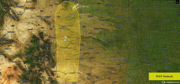
A developing surface trough on the east side of the Rockies will help increase southerly flow, which will keep warm, moist air in the region. As instability increases with daytime heating, lift from an upper level system will allow for the development of strong to severe thunderstorms this afternoon. The primary threats with these storms will be large hail and damaging winds, but an isolated tornado cannot be ruled out. These storms should continue into the evening hours.
Major Cities in Region: Scottsbluff, NE, Lamar, CO
Region 2
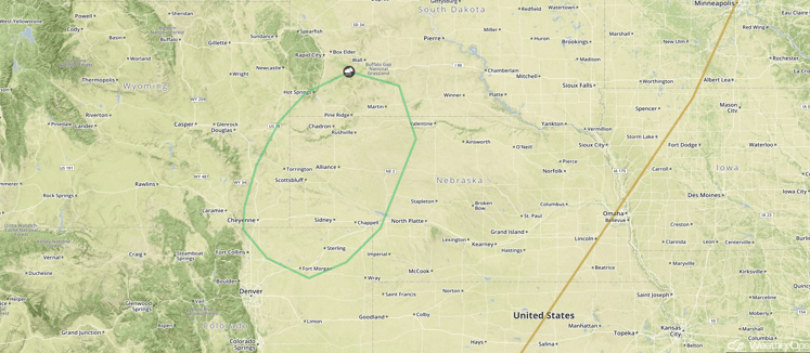
Strong to Severe Thunderstorms Possible Saturday across the Central High Plains
Strong surface heating ahead of an advancing cold front will allow for scattered showers and thunderstorms to develop during the afternoon hours. Moderate instability will allow for a few of these thunderstorms to become severe, with large hail and damaging winds the primary hazards.
Major Cities in Region: Cheyenne, WY, Scottsbluff. NE
SPC Convective Outlook for Saturday
Strong to Severe Thunderstorms Possible across North Dakota on Saturday
Thunderstorms may develop across portions of North Dakota Saturday night as a cold front pushes into the region. Modest instability combined with strong wind shear may allow for a few of these thunderstorms to become severe. Large hail and damaging winds will be the primary hazards with these storms.
Major Cities in Region: Bismarck, ND
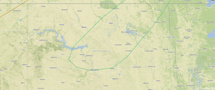
SPC Convective Outlook for Saturday
Strong to Severe Thunderstorms Possible Sunday across the Northern Plains
Strong heating and moisture transport into the region should allow instability to build, resulting in the development of thunderstorms. Strong wind shear should allow for some thunderstorms to become supercellular, with large hail and damaging winds the primary hazards. In addition to the severe weather threat, locally heavy rainfall accumulations in excess of two inches will be possible in some locations.
Major Cities in Region: Pierre, SD, Aberdeen, SD, Fargo, SD
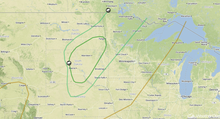
SPC Convective Outlook for Sunday
Excessive Rainfall Possible across Western Montana on Sunday
Widespread rain showers are expected to develop near the tail end of a cold front moving through the Canadian Prairies. Deep moisture in place across this region will allow for a heavy rainfall threat across western Montana on Sunday. Widespread rainfall accumulations of 1-2 inches, with locally higher amounts in excess of 3 inches, are possible.
Major Cities in Region: Great Falls, MT, Helena, MT, Billings, MT
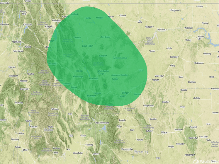
Excessive Rainfall Risk Outline for Sunday
Tropical Update
Tropical Storm Hermine (red oval) is moving northeast at 18 mph and is expected to decrease in forward speed on Saturday. Hermine will move across coastal South Carolina today and coastal North Carolina tonight before moving offshore on Saturday. Strengthening is forecast to occur as it moves offshore.
Tropical Storm Gaston (blue oval) is moving toward the east-northeast at 18 mph; this general motion is expected to continue through Saturday. The center of Gaston will move near the western Azores today, and pass north of the central Azores tonight. Maximum sustained winds are near 70 mph with higher gusts. Weakening is forecast during the next 36 hours, and Gaston is expected to become a remnant low on Saturday.
A tropical wave over the central tropical Atlantic (green oval) located about 1000 miles east of the Lesser Antilles is accompanied by disorganized showers and thunderstorms. Development of this system will be slow to occur while it approaches the Lesser Antilles and continues westward into the eastern Caribbean early next week.
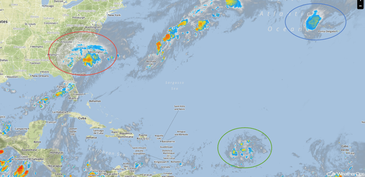
Infrared Tropical Satellite
A Look Ahead
Hermine will continue to move northeast next week as a post-tropical system, bringing the potential for heavy rain and gusty winds to coastal portions of the Mid-Atlantic and New England. Elsewhere, thunderstorms will be possible for portions of the Northern Plains for Tuesday and Wednesday.
This is just a brief look at current weather hazards. We can provide you site-specific forecast information for the purpose of protecting your personnel and assets. Try a 7-day demo right away and learn how timely precision weather information can enhance your bottom line.


