


by David Moran, on Nov 9, 2018 10:31:18 AM
An area of low pressure moving across the Great Lakes will bring a potential for snow to the region Friday into Saturday. Excessive rainfall is forecast across portions of the Northeast as a cold front moves eastward. Elevated winds and seas are expected across the Gulf of Mexico through Saturday in association with a cold front. Snow will continue across portions of New England through Saturday.
- Snow for the Great Lakes through Saturday
- Excessive Rainfall Friday for the Northeast
- Elevated Winds and Seas for the Gulf of Mexico through Saturday
- Potential for Snow Friday and Saturday across New England
- Snow for the Southern High Plains on Sunday
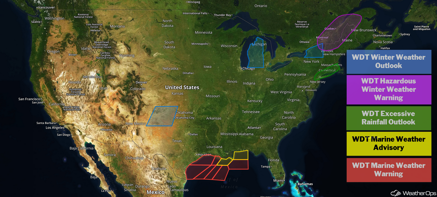
US Hazards
Snow for the Great Lakes through Saturday
Periods of light to moderate snow will continue today into at least early Saturday across much of the western Great Lakes as an intensifying area of low pressure moves through the region. Snowfall totals of 2-4 inches are forecast across Michigan and eastern Wisconsin. Higher amounts are likely across the Upper Peninsula as a result of lake enhancement.
Major Cities in Region: Green Bay, WI, Milwaukee, WI, Marquette, MI, Grand Rapids, MI, Alpena, MI
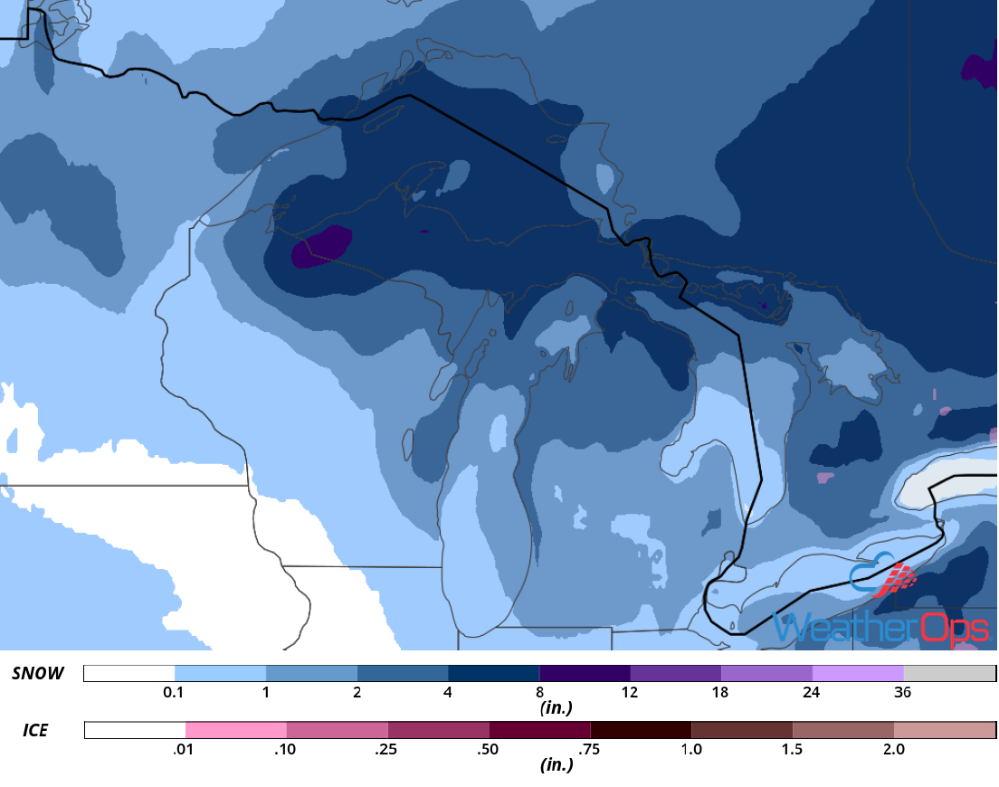
Snow Accumulation through Saturday
Excessive Rainfall Friday for the Northeast
An area of low pressure moving through the Northeast will produce showers and perhaps an isolated thunderstorm or two, mainly this afternoon and continuing through the overnight hours. Rainfall amounts will range 1-2 inches with locally higher amounts in excess of 3 inches.
Major Cities in Region: Hartford, CT, Boston, MA, Cape Cod, MA
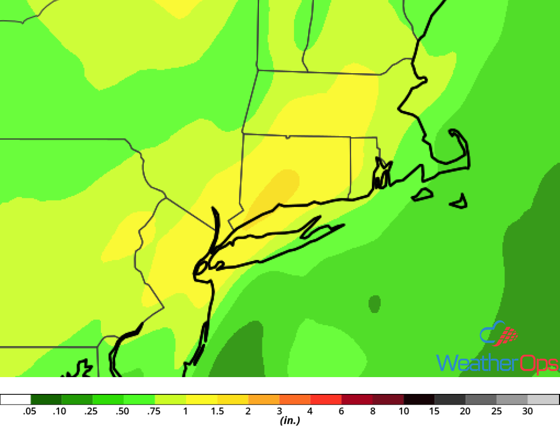
Rainfall Accumulation for Friday
Elevated Winds and Seas for the Gulf of Mexico through Saturday
A cold front moving through the Gulf of Mexico will bring elevated winds and seas through Saturday. Ahead of the front, winds will be southerly at 5-15 knots. Behind the front, winds will become northerly to north-northeasterly at 25-32 knots with gusts in excess of 37 knots. Seas will range 6-10 feet near the shore and 11-13 feet in the deeper waters. Strong thunderstorms may also develop along and ahead of the cold front.
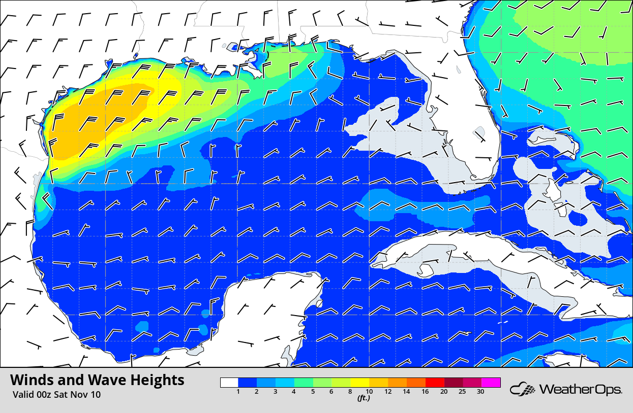
Winds and Wave Heights 6pm CST Friday
Potential for Snow Friday and Saturday across New England
Moderate to heavy snow is likely across portions of New England beginning this afternoon and continuing through Saturday morning as an area of low pressure lifts northeastward. Some light freezing rain or sleet may mix in at times but accumulations are not expected to be significant. Snow accumulations of 4-8 inches with locally higher amounts in excess of 10 inches are expected. Gusty winds could produce blowing snow, leading to hazardous travel conditions tonight and Saturday.
Major Cities in Region: Burlington, VT, Presque Isle, ME
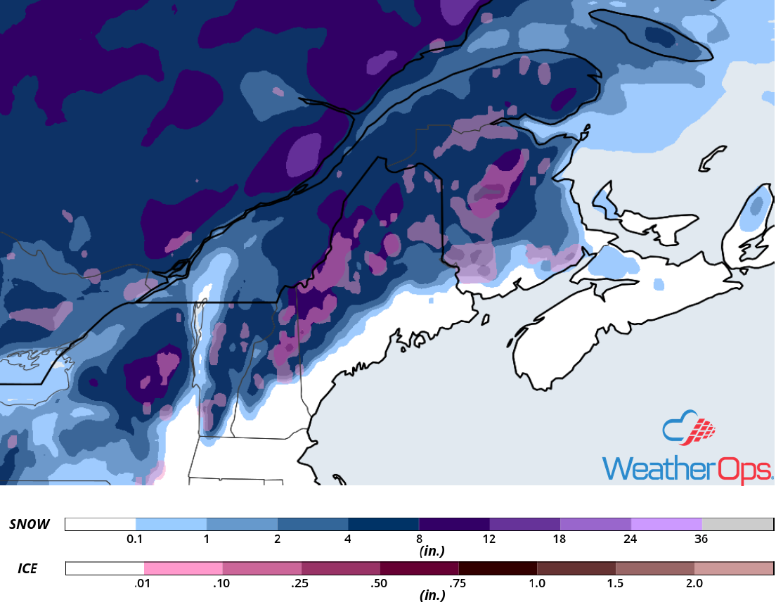
Snow Accumulation for Friday and Saturday
Snow for the Southern High Plains on Sunday
A strong cold front moving through the region early Sunday will allow for a very cold air mass to settle over the region during the day. By Sunday evening and into the overnight hours, a potent upper level disturbance is forecast to move through the region. This will bring the potential for accumulating snowfall Sunday night into Monday. Snowfall amounts in excess of 3 inches are forecast for much of the Texas Panhandle and adjacent portions of New Mexico and Oklahoma. Gusty northerly winds may develop as high pressure builds in, allowing for areas of blowing snow and reduced visibilities.
Major Cities in Region: Clovis, NM, Amarillo, TX, Guymon, OK, Elk City, OK
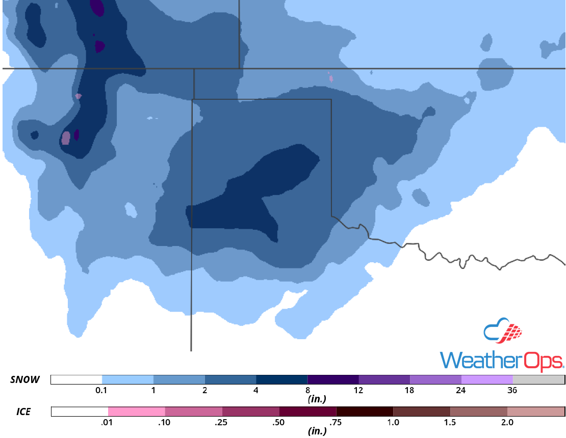
Snowfall Accumulation for Sunday
A Look Ahead
Snow will continue across west Texas and spread into Oklahoma on Monday as an upper level disturbance continues to move eastward. By Tuesday, snow could extend from the Mid South into the Northeast. Light to moderate snow may persist across New York on Wednesday. An area of low pressure may produce some light to moderate snow Thursday across the Upper Midwest and Great Lakes.
