National Weather Summary for Friday, November 18, 2016
by David Moran, on Nov 18, 2016 10:51:15 AM
An area of low pressure moving across the Plains on Friday will bring snow to portions of the Northern Plains. Further to the south, thunderstorms are expected to develop across portions of the Mississippi Valley to Southern Plains ahead of a cold front associated with the area of low pressure moving across the Northern Plains. Across southeastern Texas, and the northwestern Gulf of Mexico, thunderstorms are likely ahead of the same cold front described above. As an area of low pressure moves across the Greeat Lakes on Sunday, snow will be likely across portions of the Northeast.
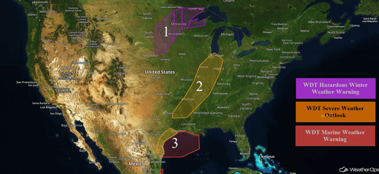
US Hazards
Region 1
An area of low pressure moving out of the Central Rockies this afternoon and will pivot across the Upper Midwest later tonight. Developing snow and strong northerly winds are expected through much of the day. Snow accumulations of 4-7 inches with isolated higher amounts in excess of 8 inches will be possible. In addition to the snow and northerly winds, dangerous wind chills and reduced visibilities to less than a mile are expected. Blizzard conditions are expected with wind gusts in excess of 45 mph. Further to the east across portions of eastern Minnesota, snowfall amounts of 8-14 inches with isolated higher amounts in excess of 16 inches will be possible.
Update 1:20pm CDT: Snow is beginning to move into Minneapolis, MN.
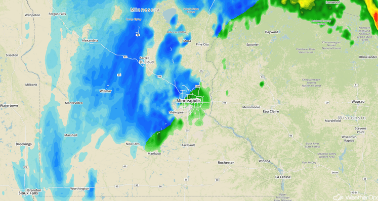
Radar 1:20pm CDT
Major Cities in Region: Sioux Falls, SD, Duluth, MN
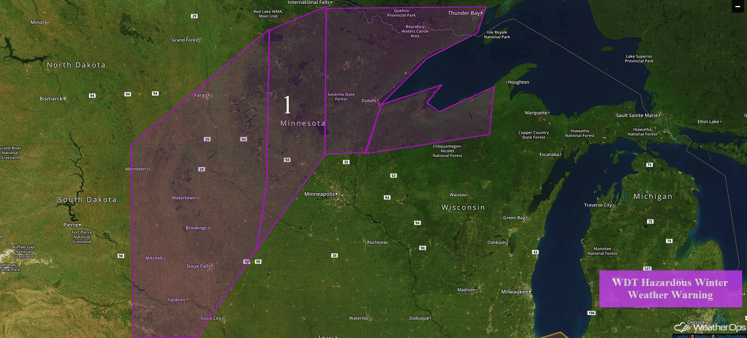
Region 1
Region 2
Storms are likely across Region 2 along a cold front progressing through the Central Plains, allowing for the risk for severe weather. Storms that become linear will have the potential for damaging winds and possibly a brief tornado through the evening hours before weakening.
Major Cities in Region: Shreveport, LA, Little Rock, AR, Memphis, TN, St. Louis, MO, Indianapolis, IN, Chicago, IL
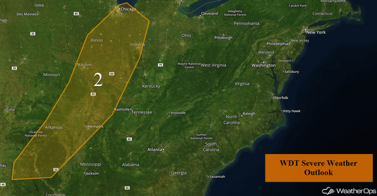
Region 2
Region 3
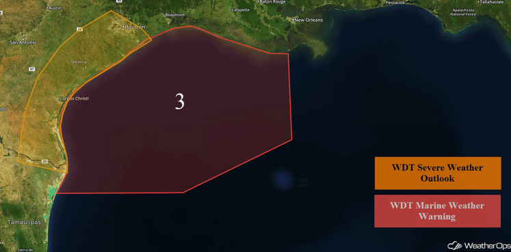
Thunderstorms will be possible along the Texas coast ahead of a cold front approaching from the northwest. The strongest storms will likely develop just ahead of the front this afternoon and early evening, and there will be a marginal risk of strong to severe thunderstorms capable of producing gusty winds. As the front moves into the northwestern Gulf of Mexico, winds will become northerly. Ahead of the front, winds will be 10-15 mph. Behind the front, winds will strengthen to near gale force. In addition, seas will build to 8-12 feet. Strong thunderstorms may also develop along the front as it moves through the western Gulf of Mexico.
Major Cities in Region: Brownsville, TX, Corpus Christi, TX, Houston, TX
Region 3
Significant Snowfall Possible for the Northeast on Sunday
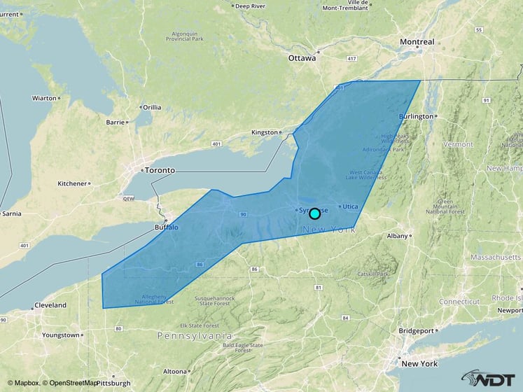
Snow will likely begin across the Northeast Saturday evening and will increase in intensity on Sunday as an area of low pressure continues to move across the Great Lakes. Moderate to heavy snow will be possible across the region with accumulations of 5-10 inches and locally higher amounts in excess of 12 inches possible. Breezy northwesterly winds may also lead to some areas of blowing snow and reduced visibilities.
Major Cities in Region: Syracuse, NY
Snowfall Risk Outline for Sunday
Tropical Update
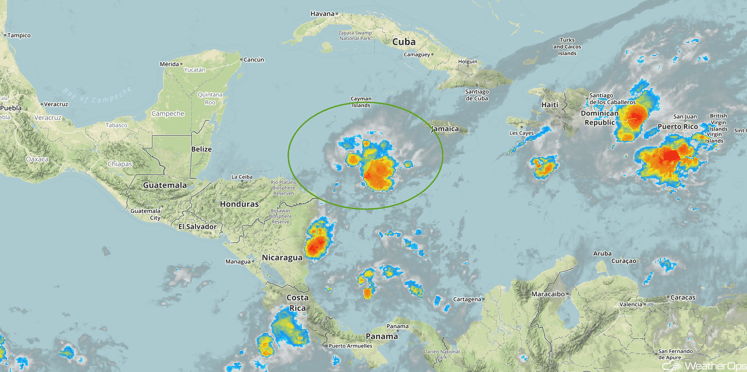
Disorganized cloudiness and showers over the southwestern Carribbean sea are associated with a broad area of low pressure. Upper level winds have become less conducive, and development will be slow over the next couple of days. After that time, environmental conditions are expected to become more conducive for gradual development, and a tropical depression could form early next week while the low moves slowly.
Tropical Infrared Satellite
A Look Ahead
An area of low pressure will develop over the Plains on Monday and will intensify. As it moves northeastward toward the Great Lakes, widespread precipitation is expected. With cold air in place, periods of snow are likely across the Upper Midwest. While there is still some uncertainty in snowfall accumulations, at least a few inches will be possible across the region.
This is just a brief look at current weather hazards. We can provide you site-specific forecast information for the purpose of protecting your personnel and assets. Try a 7-day demo right away and learn how timely precision weather information can enhance your bottom line.


