


by David Moran, on Mar 2, 2018 11:05:25 AM
Snow will continue for portions of the Northeast through Saturday morning as an area of low pressure continues to intensify off the East Coast. Excessive rainfall will also continue for the Northeast in association with this area of low pressure. An area of low pressure moving across the Rockies will bring snow to portions of the Central Rockies through Sunday morning.
- Snow Continuing for the Northeast through Saturday Morning
- Excessive Rainfall Friday for Portions of the Northeast
- Snow for Portions of the Central Rockies through Sunday Morning
- Potential for Snow Sunday through Tuesday Morning across the Northern High Plains and Plains
- Thunderstorms for the Central and Southern Plains on Sunday
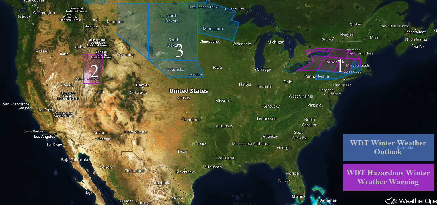 US Hazards

Snow Continuing for the Northeast through Saturday Morning
Snow will continue across the Northeast as an area of low pressure continues to intensify. From northeastern Ohio into northwestern Pennsylvania, 1-4 inches of snow with locally higher amounts in excess of 5 inches are forecast. In addition, winds 20-25 mph with gusts in excess of 40 mph will allow for blowing snow and low visibilities. Across western New York, snow accumulations of 8-12 inches with locally higher amounts in excess of 14 inches are expected. With winds in excess of 30 mph, blizzard conditions will be possible. For North Central Pennsylvania into northern New Jersey, snow accumulations will range 2-4 inches with locally higher amounts in excess of 5 inches.
Across northern Pennsylvania into central New York, 7-10 inches with locally higher amounts in excess of a foot are expected. For northern portions of New York, 8-12 inches with locally higher amounts in excess of 14 inches are forecast. Further east across eastern New York into western portions of Connecticut and Massachusetts, 3-5 inches with locally higher amounts in excess of 6 inches are expected. In the higher elevations, snowfall amounts will range 8-12 inches with locally higher amounts in excess of 16 inches. For western portions Connecticut and Massachusetts, 1-3 inches of snow with locally higher amounts in excess of 4 inches are forecast. Across central Massachusetts, 6-9 inches of snow are expected. For southern portions of Vermont and New Hampshire, snowfall amounts will range 5-8 inches.
Major Cities in Region: Buffalo, NY, Syracuse, NY, Albany, NY, Providence, RI
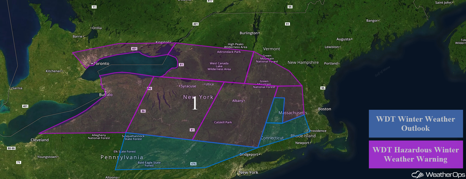 Region 1
Excessive Rainfall Friday for Portions of the Northeast
An area of low pressure will begin to move further offshore and intensify, bringing continued rainfall to portions of the Northeast. An additional 1-3 inches of rain and locally higher amounts in excess of 4 inches expected. This will lead to an increased risk for flooding.
Major Cities in Region: Albany, NY, New York, NY, Providence, RI, Boston, MA
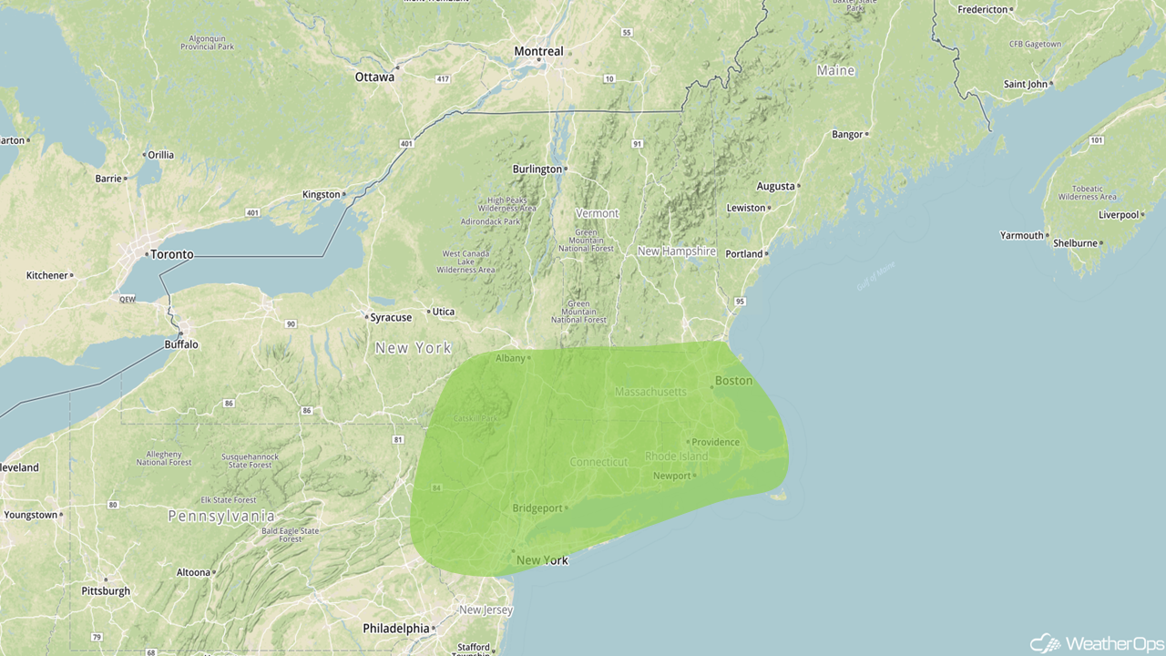 Excessive Rainfall Risk Outline for Friday
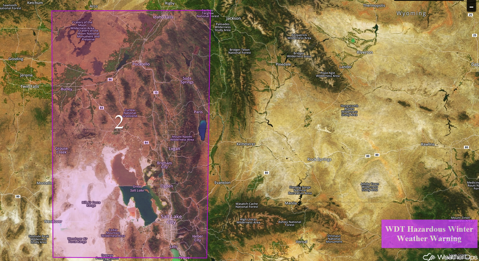
Snow for Portions of the Central Rockies through Sunday Morning
As an area of low pressure moves across the Rockies, heavy snow is expected for portions of the Central Rockies through Sunday. Accumulations of 6-10 inches with locally higher amounts in excess of a foot are forecast in the valleys. In the higher elevations, 12-20 inches are expected with locally higher amounts in excess of 2 feet. Winds 20-30 mph with gusts in excess of 35 mph will limit visibilities to less than a mile at times.
Major Cities in Region: Pocatello, ID, Idaho Falls, ID, Salt Lake City, UT
Potential for Snow Sunday through Tuesday Morning across the Northern High Plains and Plains
The same area of low pressure described above will intensify and move into the Plains Sunday, bringing snow to portions of the Northern High Plains and Northern Plains through Tuesday morning. Across eastern Montana and northeastern Wyoming southeastward into Nebraska, snowfall accumulations will range 2-6 inches with locally higher amounts in excess of 8 inches. Across the Dakotas and portions of Minnesota, 4-8 inches of snow with locally higher amounts in excess of a foot are forecast. In addition, ice and sleet accumulations up to a quarter of an inch are expected across the Dakotas.
Major Cities in Region: Billings, MT, Minot, ND, Bismarck, ND, Pierre, SD, Sioux Falls, SD, Omaha, NE, International Falls, MN, Duluth, MN
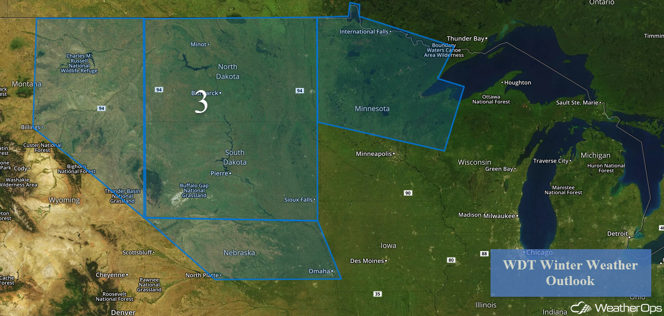 Region 3
Thunderstorms for the Central and Southern Plains on Sunday
An area of low pressure will develop across the Plains on Sunday. Ahead of the low, southerly winds will pull warm, moist air northward, allowing instability to build. A dryline will set up across western Oklahoma and northwest Texas, acting as a focus for the development of thunderstorms during the afternoon and evening. Severe winds and large hail will be the primary hazards, but an isolated tornado or two cannot be ruled out.
Major Cities in Region: Oklahoma City, OK, Dallas, TX, Tulsa, OK, Topeka, KS, Omaha, NE, Kansas City, MO
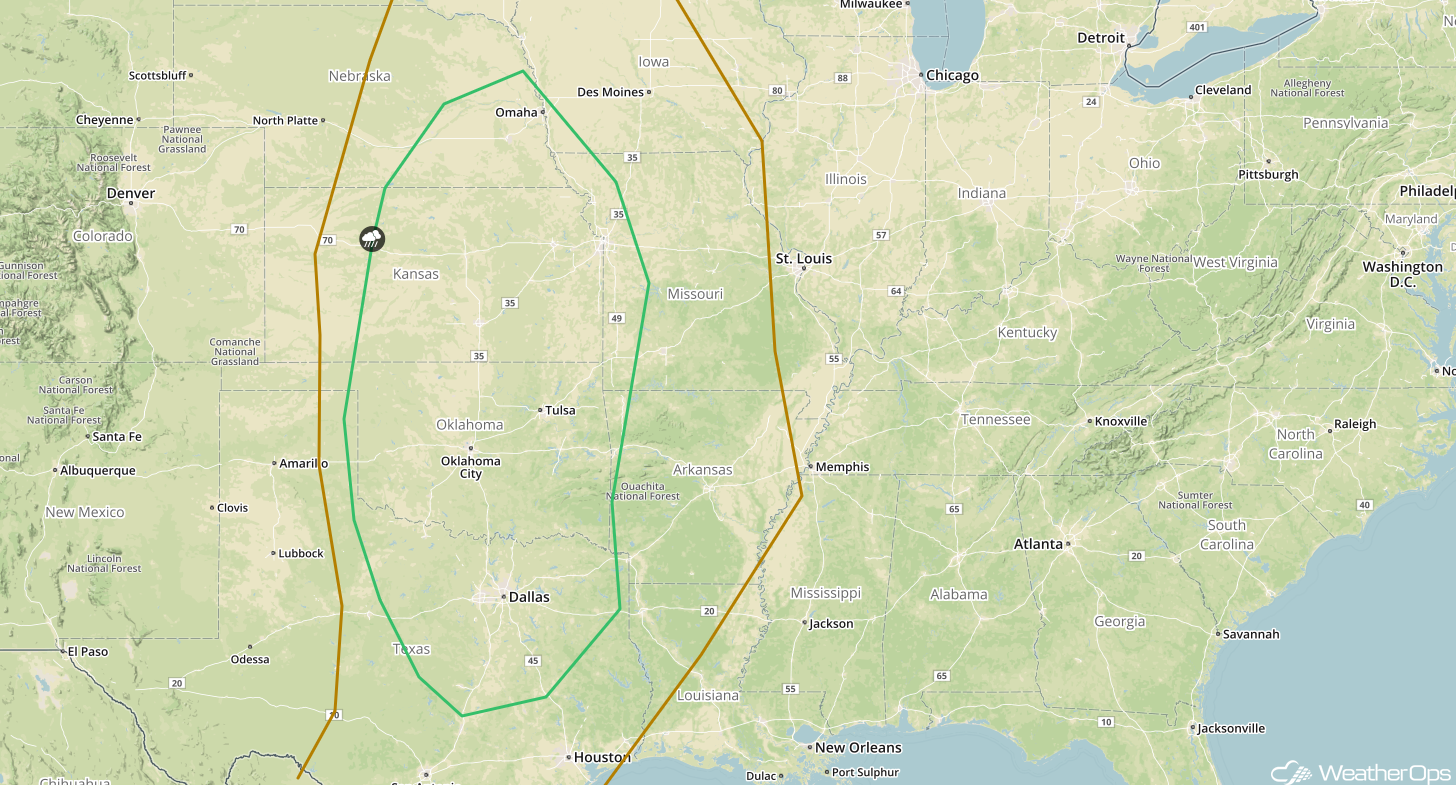 SPC Convective Outlook for Sunday
A Look Ahead
There will be the potential for snowfall across much of the Northeast Wednesday and Thursday as an area of low pressure intensifies off the East Coast. While specific details are unknown at the time, there appears to be the potential for several inches of snow.
That is a brief look at current weather hazards. We can provide you site-specific weather forecast information to protect your staff and assets and to assess your weather risk. Try a 7-day demo right away and learn how timely precision weather information can enhance your bottom line.
