


by David Moran, on Mar 16, 2018 11:08:32 AM
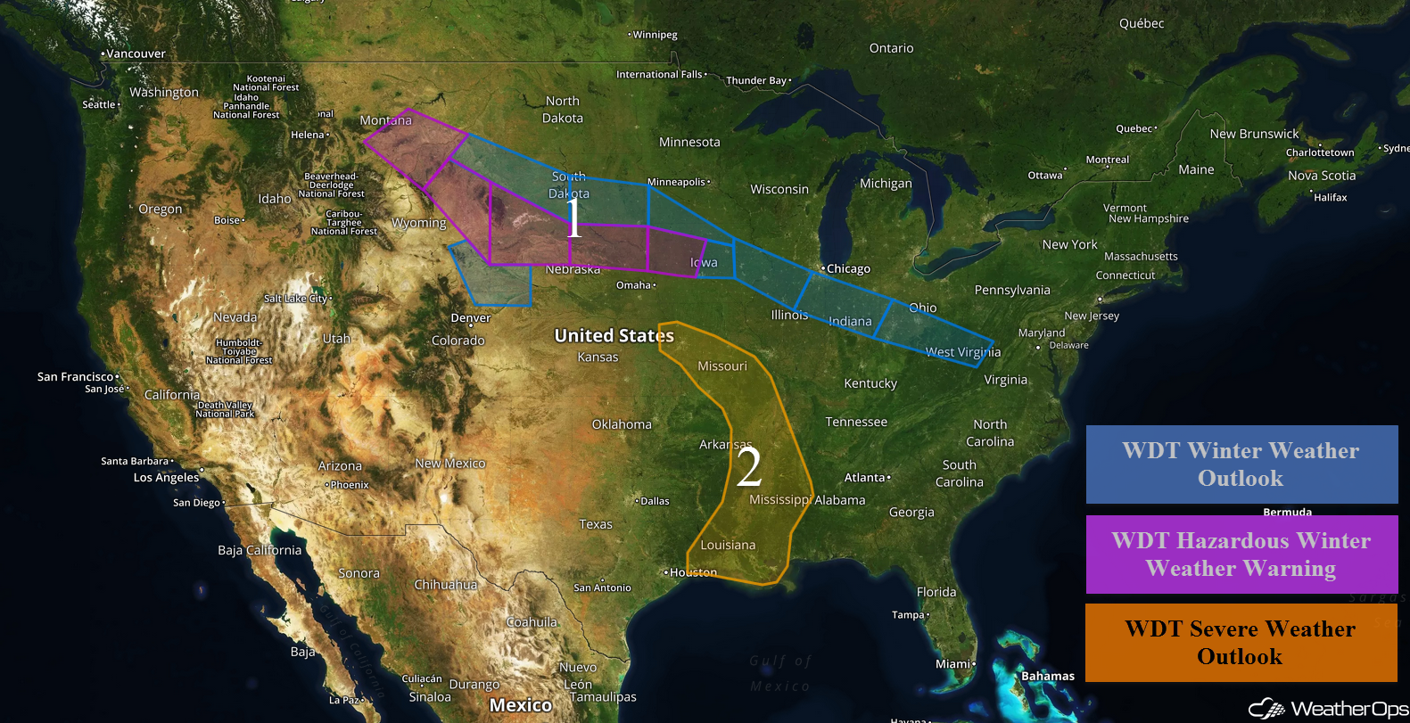
Snow will continue for portions of the Plains into the Midwest through Saturday in association with an area of low pressure. Thunderstorms may develop from the Missouri Valley into the Lower Mississippi Valley on Friday as a disturbance approaches the region.
- Freezing Rain and Snow from the Plains into the Midwest through Saturday
- Thunderstorms Friday from the Missouri Valley into the Lower Mississippi Valley
- Potential for Thunderstorms across the Tennessee Valley on Saturday
- Risk for Thunderstorms Saturday for Northeast Texas
- Thunderstorms from Texarkana into West-Central Mississippi on Sunday
- Excessive Rainfall Sunday from the Lower Mississippi Valley into the Deep South
 US Hazards

Snow from the Plains into the Midwest through Saturday
Freezing rain and snow will continue for portions of the Plains and Midwest as an upper level low moves into the Rockies. Moderate to heavy snow is forecast to expand eastward out of Montana and Wyoming with snow amounts ranging 3-6 inches with locally higher amounts in excess of 8 inches. Across portions of South Dakota and Nebraska, up to a quarter inch of ice is forecast. Across southern Minnesota and northern Iowa, 1-3 inches of snow with locally higher amounts in excess of 4 inches are expected. From eastern Iowa eastward into western West Virginia, ice accumulations will range 0.05-0.15 inch.
Major Cities in Region: Billings, MT, Cheyenne, WY, Pierre, SD, Sioux Falls, SD, Des Moines, IA, Peoria, IL, Indianapolis, IN, Columbus, OH
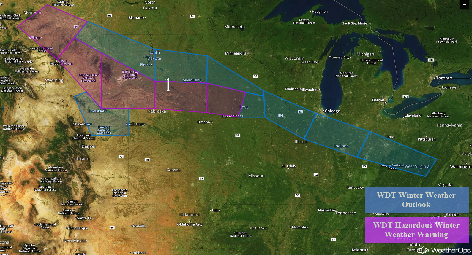 Region 1
Thunderstorms Friday from the Missouri Valley into the Lower Mississippi Valley
Thunderstorms may develop from Missouri into Louisiana on Friday as a shortwave trough approaches the region. Instability will build through the afternoon, allowing thunderstorms to develop. A few storms may become severe with hail and damaging winds the primary hazards, but an isolated tornado or two cannot be ruled out.
Major Cities in Region: Kansas City, MO, Memphis, TN, Jackson, MS, New Orleans, LA
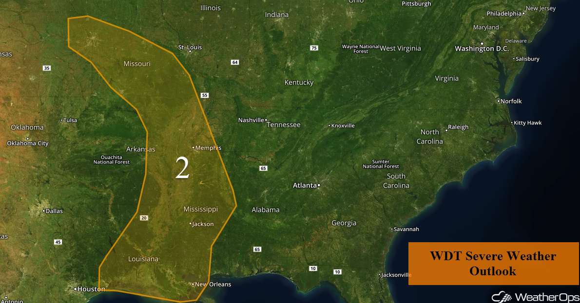 Region 2
Potential for Thunderstorms across the Tennessee Valley on Saturday
Scattered showers and thunderstorms may develop across the Tennessee Valley on Saturday as instability builds through the afternoon. While widespread severe weather is not expected, some storms may produce hail and damaging winds.
Major Cities in Region: Knoxville, TN, Blacksburg, VA
 SPC Convective Outlook for Saturday
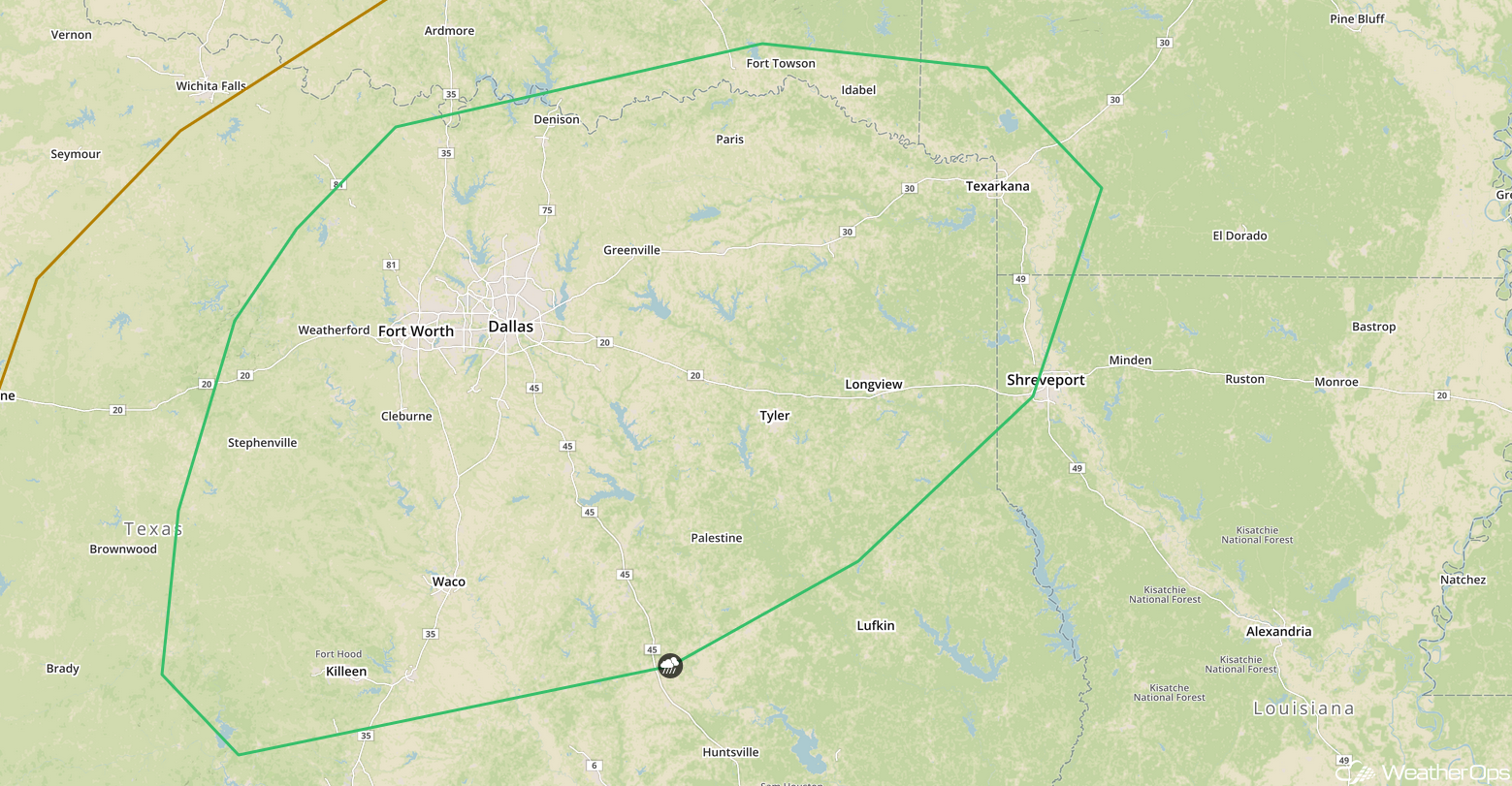
Risk for Thunderstorms Saturday for Northeast Texas
Gulf moisture will allow instability to build across the region on Saturday. An area of low pressure moving into the area from Mexico will allow for strong upper level winds to overspread the region. This will support the development of isolated thunderstorms along a stalled front. Hail and damaging winds will be the primary hazards with these storms.
Major Cities in Region: Dallas, TX, Shreveport, LA
 SPC Convective Outlook for Saturday
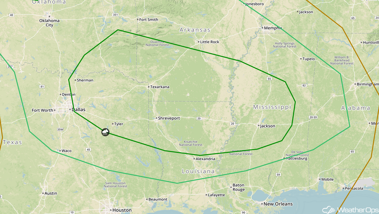
Thunderstorms from Texarkana into West-Central Mississippi on Sunday
An upper level trough is forecast to track into the Southern Plains on Sunday where plentiful moisture is expected. Instability will allow for the development of showers and thunderstorms from Texas into Mississippi. Severe winds and large hail will be the primary hazards, but an isolated tornado or two cannot be ruled out.
Major Cities in Region: Dallas, TX, Shreveport, LA, Jackson, MS
 SPC Convective Outlook for Sunday
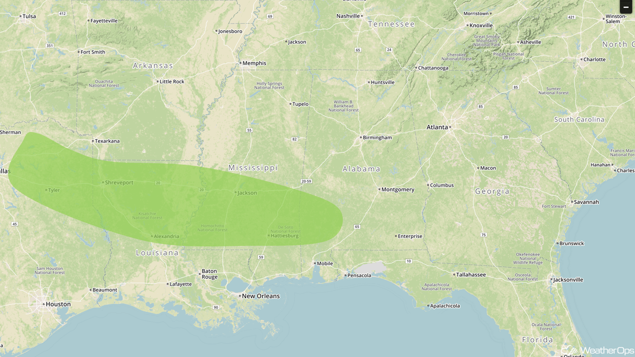
Excessive Rainfall Sunday from the Lower Mississippi Valley into the Deep South
Shower and thunderstorm activity will shift into the Deep South late Sunday and Sunday Night. Rainfall amounts will range 1-2 inches, allowing for a threat for flooding and runoff.
Major Cities in Region: Tyler, TX, Shreveport, LA, Alexandria, LA, Jackson, MS, Hattiesburg, MS
 Excessive Rainfall Risk Outline for Sunday
A Look Ahead
An area of low pressure moving across portions of the Northern Plains and Midwest Tuesday and Wednesday will bring the potential for snow to the region. While snowfall amounts are uncertain at this time, there will be the potential for several inches of snow.
That is a brief look at current weather hazards. We can provide you site-specific weather forecast information to protect your staff and assets and to assess your weather risk. Try a 7-day demo right away and learn how timely precision weather information can enhance your bottom line.
