National Weather Summary for Friday, January 19, 2018
by David Moran, on Jan 19, 2018 10:41:43 AM
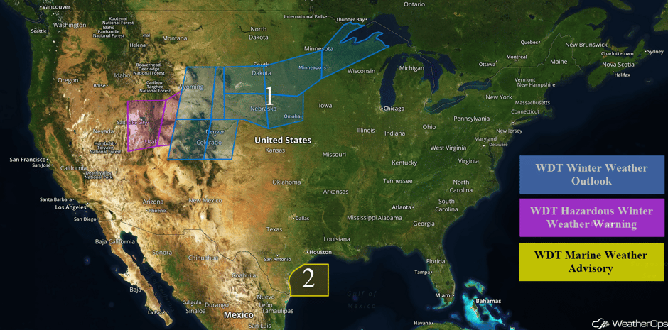
Snow is expected from the Rockies into the Upper Midwest Friday through Monday as an upper level trough moves over the region. Elevated winds and seas are expected for portions of the western Gulf of Mexico in association with an area of low pressure in the Bay of Campeche.
- Snow from the Rockies into the Upper Midwest through Monday
- Elevated Winds and Seas Friday and Saturday for the Western Gulf of Mexico
 US Hazards
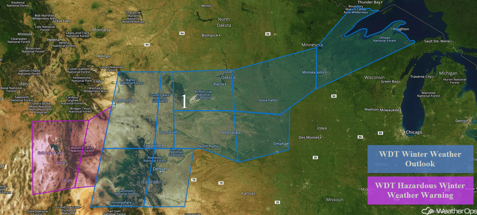
Snow from the Rockies into the Upper Midwest through Monday
An upper level trough is forecast to move across the Rockies Friday into Saturday, allowing a cold front to push southward. Moderate to heavy snowfall is expected across portions of Utah beginning Friday evening. Snow accumulations of 3-6 inches with locally higher amounts in excess of 8 inches are forecast in the valleys of Utah. In the higher elevations, accumulations of 10-15 inches with locally higher amounts in excess of 18 inches are expected. Gusty winds will allow for blowing snow, reducing visibilities to less than a quarter mile at times. Further east across portions of Colorado and Wyoming, snow accumulations will range 2-5 inches with locally higher amounts in excess of 6 inches in the valleys. In the higher elevations, 5-8 inches of snow with locally higher amounts in excess of 10 inches are forecast. Along the Front Range of Colorado, 2-4 inches of snow with locally higher amounts in excess of 5 inches are expected Saturday evening through Sunday night.
Into the Plains, an area of low pressure is forecast to develop in southeastern Colorado and move northeastward through the weekend. Accumulations of 2-5 inches are forecast for western and central portions of Nebraska and South Dakota through late Sunday. Across eastern portions of Nebraska and South Dakota into southwestern Minnesota, snowfall accumulations of 5-8 inches with locally higher amounts in excess of 10 inches are expected through Monday. From southeastern Minnesota northeastward into the Upper Peninsula of Michigan, 6-9 inches with locally higher amounts in excess of a foot are forecast, in addition to light ice accumulations.
Major Cities in Region: Salt Lake City, UT, Cheyenne, WY, North Platte, NE, Pierre, SD, Sioux Falls. SD, Omaha, ME, Minneapolis, MN
 Region 1
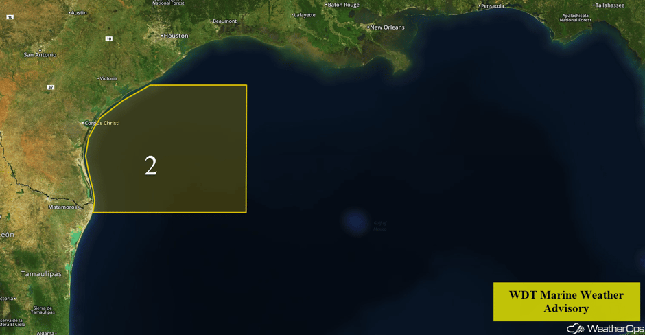
Elevated Winds and Seas Friday and Saturday for the Western Gulf of Mexico
A weak area of low pressure developing in the Bay of Campeche will move northward and bring a period of enhanced winds and seas to portions of the western Gulf Friday and Saturday. Seas of 6-10 feet are forecast in the deeper waters and 3-6 feet near the shore. The center of the low is forecast to set up along the far southern Texas coast, with winds to the west of it becoming west-northwesterly. On the east side of it, winds will be from the east-southeast. In addition, some isolated showers and thunderstorms may develop. Conditions should improve by late Saturday afternoon.
 Region 2
A Look Ahead
An area of low pressure will move into southeastern Canada on Tuesday. A wintry mix transitioning to snow is forecast across northern Maine. Due to some variability in the forecast, there is some uncertainty in precipitation type. At this time, total snow accumulations of 4-8 inches are forecast.
This is just a brief look at current weather hazards. We can provide you site-specific weather forecast information to protect your staff and assets and to assess your weather risk. Try a 7-day demo right away and learn how timely precision weather information can enhance your bottom line.


