


by David Moran, on Aug 17, 2018 11:12:49 AM
A disturbance moving into the Northern Rockies will allow for the development of thunderstorms across portions of Idaho and Southwest Montana on Friday. Upslope flow and plentiful low level moisture will support thunderstorm development across the Central and Southern High Plains. Activity across the Southern High Plains may pose a risk for excessive rainfall. Daytime heating will create a favorable environment for thunderstorms from the Ozarks into the Tennessee and Ohio Valleys. A cold front will be the focus for thunderstorm activity from the Northeast into the Mid Atlantic. Heavy rain may accompany some of these storms.
- Thunderstorms for the Northern Rockies on Friday
- Risk for Thunderstorms Friday for the Central and Southern High Plains
- Excessive Rainfall for the Southern High Plains on Friday
- Potential for Thunderstorms Friday from the Ozarks into the Tennessee and Ohio Valleys
- Thunderstorms for the Northeast and Mid Atlantic Friday
- Risk for Excessive Rainfall Friday across the Northeast
- Thunderstorm Potential from the Western High Plains to the Southern Plains on Saturday
- Excessive Rainfall Saturday across the Western High Plains and Southern Plains
- Thunderstorms from the Great Plains to the Ozarks on Sunday
- Potential for Excessive Rainfall Sunday across the Plains and Ozarks
- Tropical Update
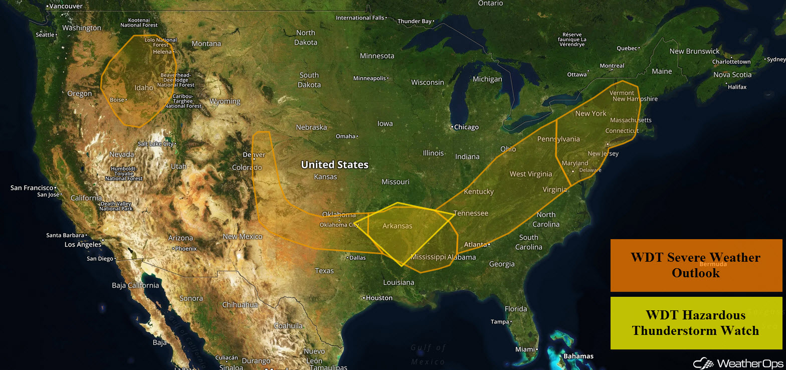
US Hazards
Thunderstorms for the Northern Rockies on Friday
An upper level disturbance will move out of Washington and Oregon and into Idaho later this morning. Ahead of the trough, instability and increasing mid-level winds will support the development of isolated thunderstorms within the higher terrain this afternoon. Damaging winds will be the primary hazard with these storms as they move northeastward into southwest Montana.
Major Cities in Region: Boise, ID, Missoula, MT, Helena, MT
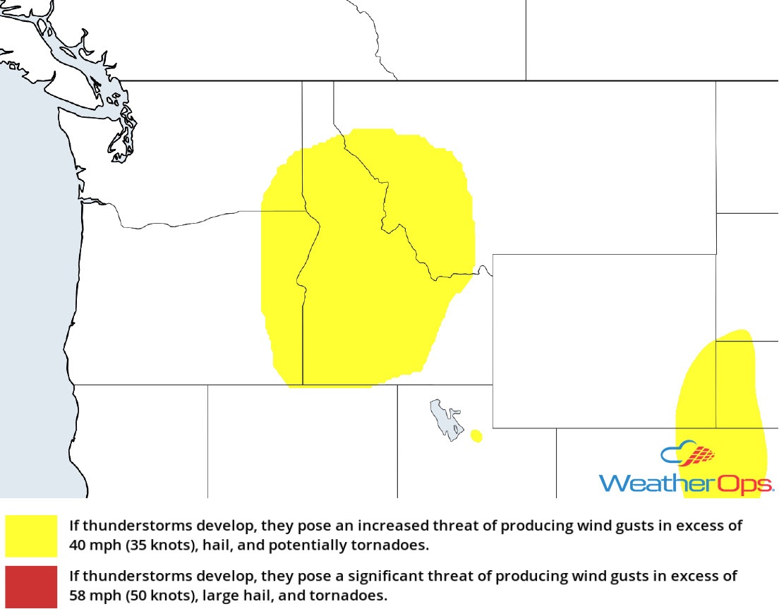
Thunderstorm Risk for Friday
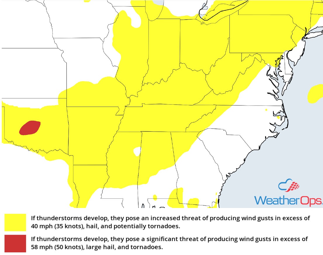
Risk for Thunderstorms Friday for the Central and Southern High Plains
By late afternoon, upslope winds and plentiful moisture will allow for scattered thunderstorm development along the lee side of the Rockies. Strengthening west-northwest winds in the mid-levels will allow storms to move eastward into the Plains throughout the evening. Damaging winds and large hail will be the primary hazards with the stronger storms.
Major Cities in Region: Denver, CO, Amarillo, TX, Guymon, OK
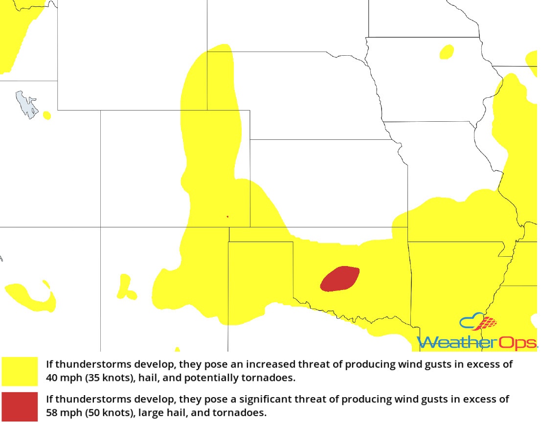
Thunderstorm Risk for Friday
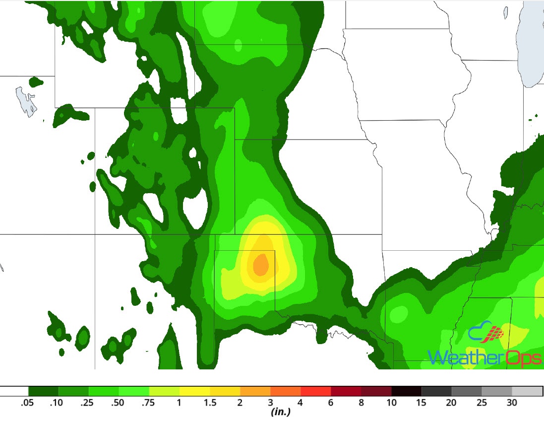
Excessive Rainfall for the Southern High Plains on Friday
In addition to the thunderstorms described above, there will be a risk for excessive rainfall. Rainfall totals will range 1-2 inches with locally higher amounts in excess of 3 inches.
Major Cities in Region: Albuquerque, NM, Trinidad, CO, Tucumcari, NM
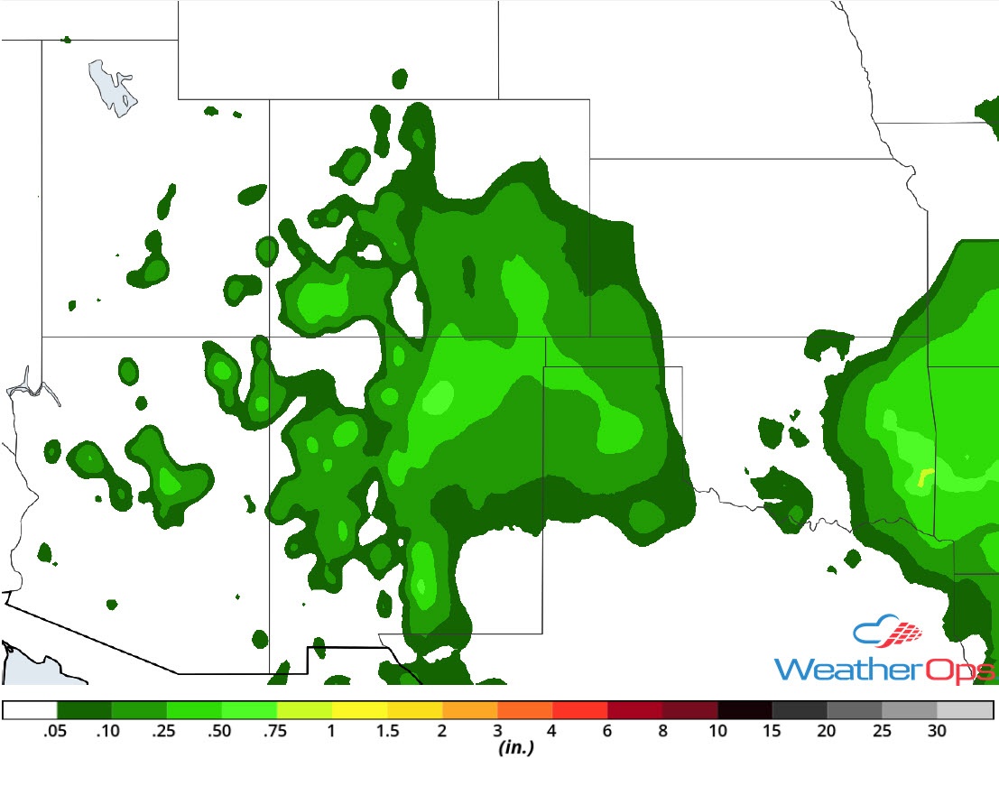
Rainfall Accumulation for Friday
Potential for Thunderstorms Friday from the Ozarks into the Tennessee and Ohio Valleys
Showers and embedded heavy thunderstorms are ongoing from Northeast Arkansas northeastward into the Tennessee and Ohio Valleys. Damaging winds will be the primary hazards with these storms. As daytime heating increases, thunderstorms may become more widespread and intense during the afternoon and early evening. Damaging winds and large hail will be the primary hazards with these storms.
Major Cities in Region: Springfield, MO, Evansville, IL, Nashville, TN, Lexington, KY, Columbus, OH, Knoxville, TN
Thunderstorm Risk for Friday
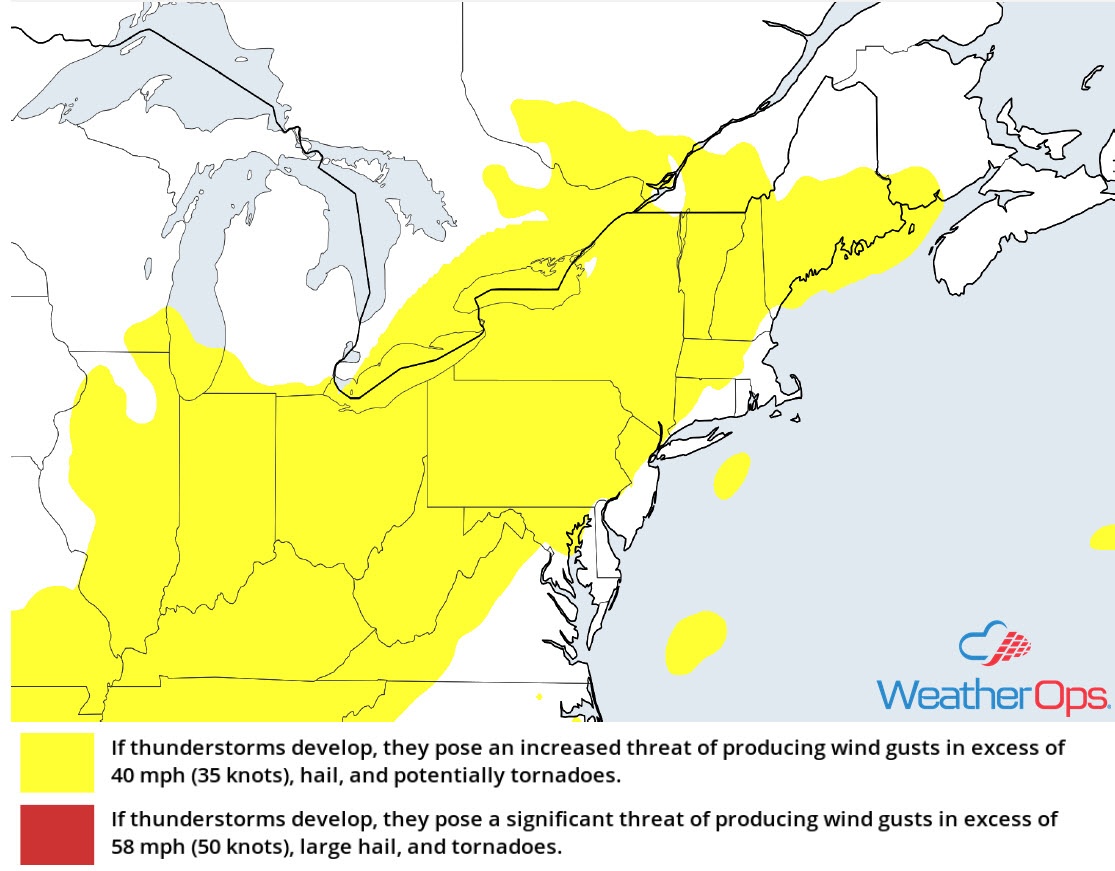
Thunderstorms for the Northeast and Mid Atlantic Friday
Showers are ongoing in association with a warm front lifting through New England. While an isolated strong storm cannot be ruled out, the greater threat will be during the afternoon and evening ahead of a cold front. Moisture and instability will increase later today with scattered thunderstorms and isolated severe thunderstorms expected to develop. Damaging winds and large hail will be the primary hazards, but a brief tornado or two cannot be ruled out.
Major Cities in Region: Pittsburgh, PA, Buffalo, NY, Rochester, NY, Philadelphia, PA, New York, NY, Albany, NY, Burlington, VT
Thunderstorm Risk for Friday
Risk for Excessive Rainfall Friday across the Northeast
The thunderstorm activity described above will have a potential to produce heavy rainfall. Rainfall amounts of 1-2 inches with locally higher amounts in excess of 3 inches are expected.
Major Cities in Region: Syracuse, NY, Albany, NY, Burlington, VT, Augusta, ME
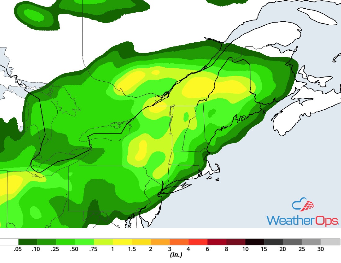
Rainfall Accumulation for Friday
Thunderstorm Potential from the Western High Plains to the Southern Plains on Saturday
Showers and thunderstorms, a few severe, are forecast to develop along the lee side of the Rockies and Western High Plains late Saturday afternoon and evening. Increasing instability and wind shear will support a risk of severe thunderstorms Saturday night as they congeal into a complex. This complex will continue eastward across southwest Kansas, the Texas Panhandle, and portions of Oklahoma Saturday night through early Sunday morning. Damaging winds and hail will be the primary hazards, but an isolated tornado or two cannot be ruled out.
Major Cities in Region: Denver, CO, Scottsbluff, NE, Rapid City, SD, Goodland, KS, Amarillo, TX, Guymon, OK, North Platte, NE, Pierre, SD
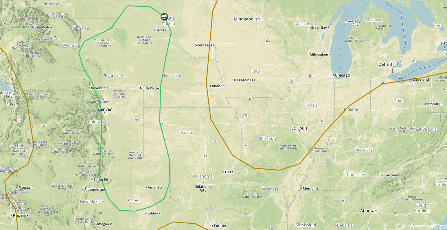
SPC Convective Outlook for Saturday
Excessive Rainfall Saturday across the Western High Plains and Southern Plains
Some of the thunderstorm activity described above will have the potential to produce heavy rainfall. Rainfall totals will range 1-2 inches with locally higher amounts in excess of 3 inches. Given recent heavy rainfall, there will be a risk for flash flooding.
Major Cities in Region: Amarillo, TX, Guymon, OK, Woodward, OK
Rainfall Accumulation for Saturday
Thunderstorms from the Great Plains to the Ozarks on Sunday
Scattered showers and thunderstorms, a few severe, are likely to be ongoing early Sunday morning across portions of Kansas, Oklahoma, and western Arkansas. Later in the day, a new round of thunderstorms may develop ahead of a cold front. The primary hazards with these storms will be damaging winds and hail.
Major Cities in Region: Oklahoma City, OK, Tulsa, OK, Fort Smith, AR, Joplin, MO, Little Rock, AR
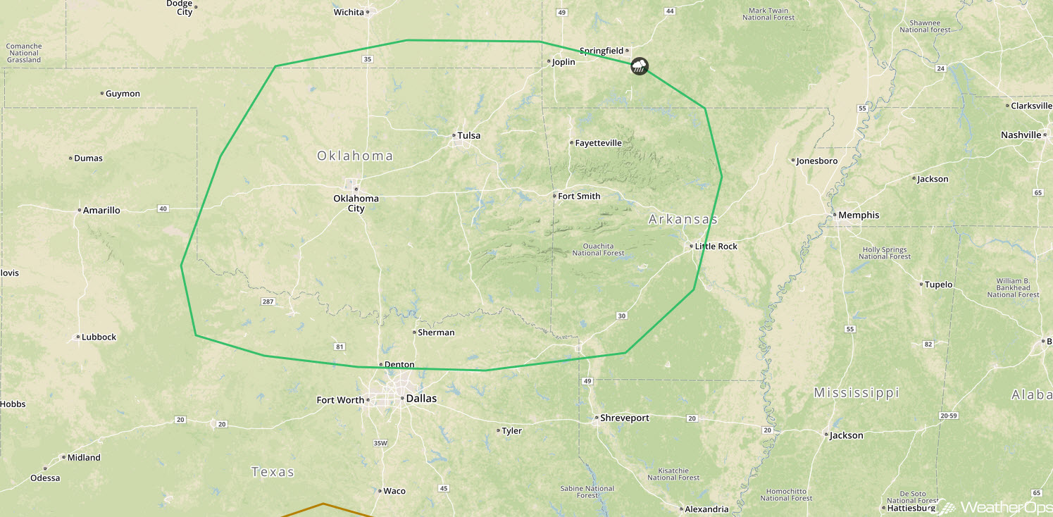
SPC Convective Outlook for Sunday
Potential for Excessive Rainfall Sunday across the Plains and Ozarks
In addition to the thunderstorm potential above, there will be a risk for excessive rainfall. Multiple rounds of precipitation are expected with 1.50-2.00 inches of rainfall forecast. This will result in a potential for flash flooding.
Major Cities in Region: North Platte, NE, Pierre, SD, Grand Island, NE, Wichita, KS, Oklahoma City, OK, Tulsa, OK, Joplin, MO, Fayetteville, AR. Springfield, MO
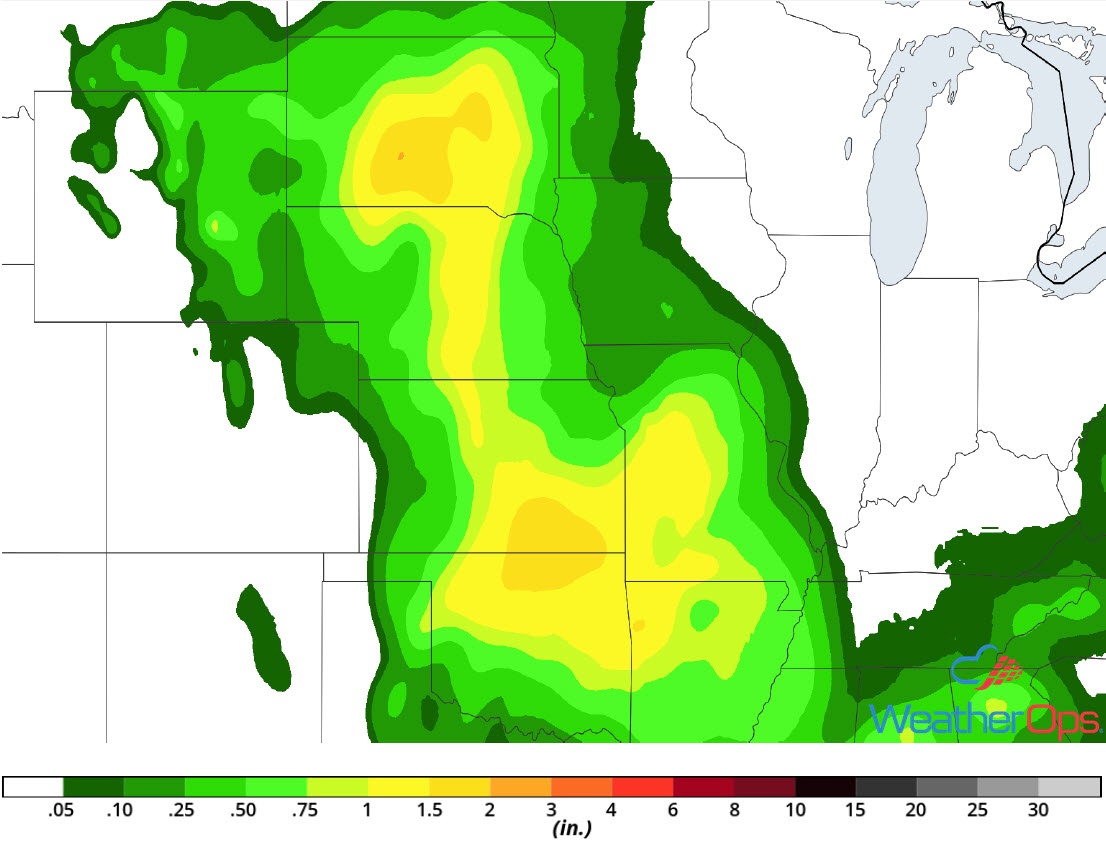
Rainfall Accumulation for Sunday
Tropical Update
Tropical Storm Ernesto (green oval) is 695 miles north-northwest of the Azores and moving northeastward at 30 mph. This motion is expected to continue with an increase in forward speed over the next day or two. Sustained winds are near 45 mph with higher gusts. Ernesto is expected to become a post-tropical cyclone tonight and extratropical on Saturday.
A tropical wave (red oval) located 400 miles east-southeast of the Windward Islands continues to produce disorganized showers and thunderstorms. Significant development is not anticipated. The system is moving westward at 15 mph and is forecast to move through the Windward Islands on Saturday, and could bring locally heavy rainfall to portions of the Lesser Antilles over the next couple of days.
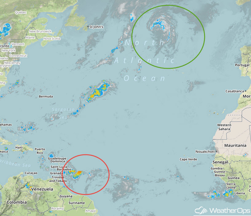
Enhanced Infrared Satellite
A Look Ahead
Heavy rainfall will stretch from the Mid Mississippi Valley into the Great Lakes on Monday as an area of low pressure moves northeastward. Rain will continue to move across the Great Lakes on Tuesday. By late Tuesday and into Wednesday, showers and thunderstorms will extend from the Northeast into the Tennessee Valley. An area of low pressure may bring a risk for thunderstorms to portions of the Northern Plains on Thursday.
