National Weather Summary for Friday, August 11, 2017
by David Moran, on Aug 11, 2017 10:56:34 AM
Thunderstorms may develop across portions of the High Plains on Friday as instability increases across the region. A cold front moving through the Midwest into the Northeast will allow for the development of thunderstorms from the Lower Mississippi Valley into the Northeast on Friday. A stalled front will be the focus for thunderstorms across West Texas, as well as excessive rainfall across the Southern Plains Friday.
- Thunderstorm Potential for the Northern and Central High Plains on Friday
- Thunderstorms Friday from the Lower Mississippi Valley into the Northeast
- Risk for Thunderstorms across West Texas on Friday
- Excessive Rainfall Friday for the Southern Plains
- Potential for Thunderstorms for the Northern and Central High Plains on Saturday
- Thunderstorm Risk Saturday for the Red River
- Thunderstorms for the Northeast on Saturday
- Continued Excessive Rainfall Sunday across the Southern Plains
- Risk for Thunderstorms for the Central and Southern High Plains on Sunday
- Thunderstorm Potential Sunday for Maine
- Tropical Update
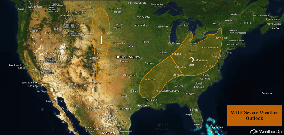 US Hazards
Thunderstorm Potential for the Northern and Central High Plains on Friday
Although moisture and overall severe potential should be fairly limited, some storms should be able to develop due to upslope flow. A few of the stronger cells will have the potential for large hail and damaging winds.
Major Cities in Region: Denver, CO, Cheyenne, WY
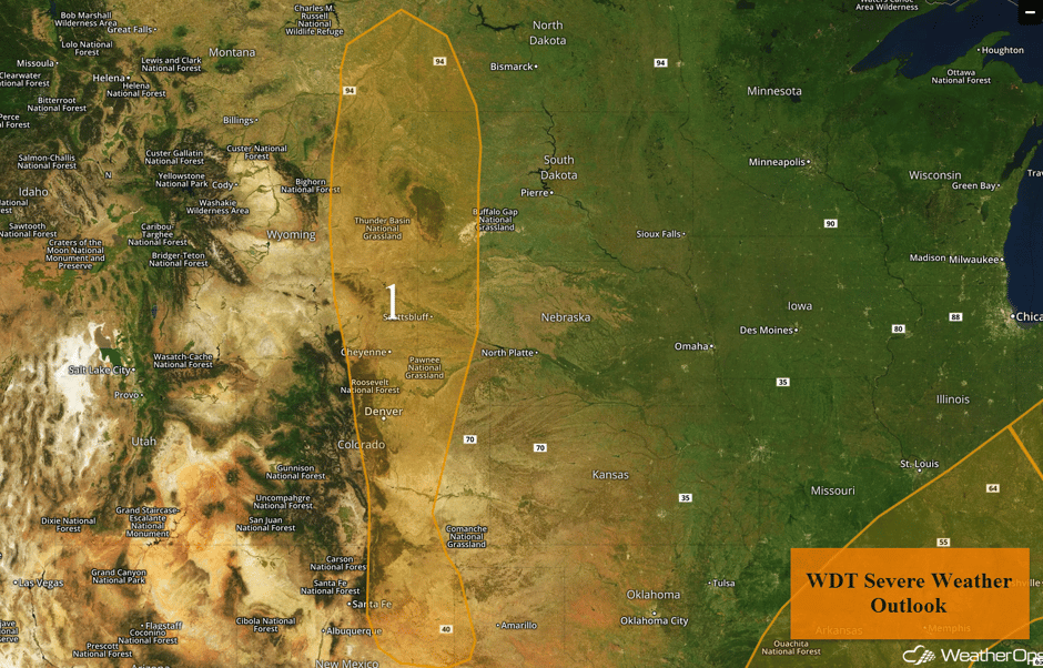 Region 1
Thunderstorms Friday from the Lower Mississippi Valley into the Northeast
Remnants of a line of storms from overnight from the Ozarks to the Red River will be the focus for additional thunderstorm development. Damaging winds will be the primary hazard from the Lower Mississippi Valley into the Tennessee Valley. Further to the north and east, from portions of the Midwest and into the Northeast, clusters of storms and individual supercells may develop, with large hail and damaging winds the primary hazards.
Update 11:48pm CDT: Severe thunderstorms capable of damaging winds in southeastern Missouri.
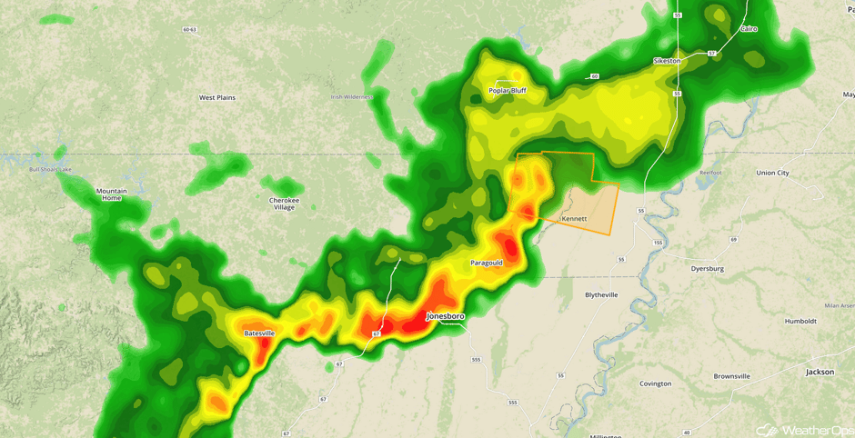 Radar 11:48am CDT
Update 12:35pm CDT: Severe thunderstorms capable of damaging winds developing across Arkansas.
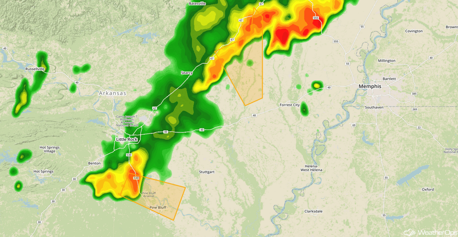 Radar 12:35pm CDT
Update 1:02pm CDT: Severe thunderstorm capable of hail and damaging winds in NE Michigan.
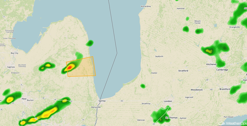 Radar 1:02pm CDT
Major Cities in Region: Shreveport, LA, Memphis, TN, Nashville, TN, Knoxville, TN, Cleveland, OH, Pittsburgh, PA, Washington, DC
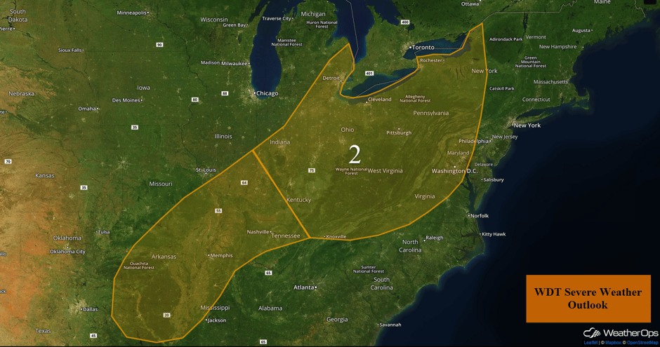 Region 2
Excessive Rainfall Friday for the Southern Plains
Heavy rainfall is forecast across the Southern Plains on Friday along a stalled front. With rich moisture in place, rainfall amounts of 1.5-2 inches with locally heavier amounts in excess of 2.5 inches are expected.
Major Cities in Region: Amarillo, TX, Ardmore, OK, Fort Smith, AR
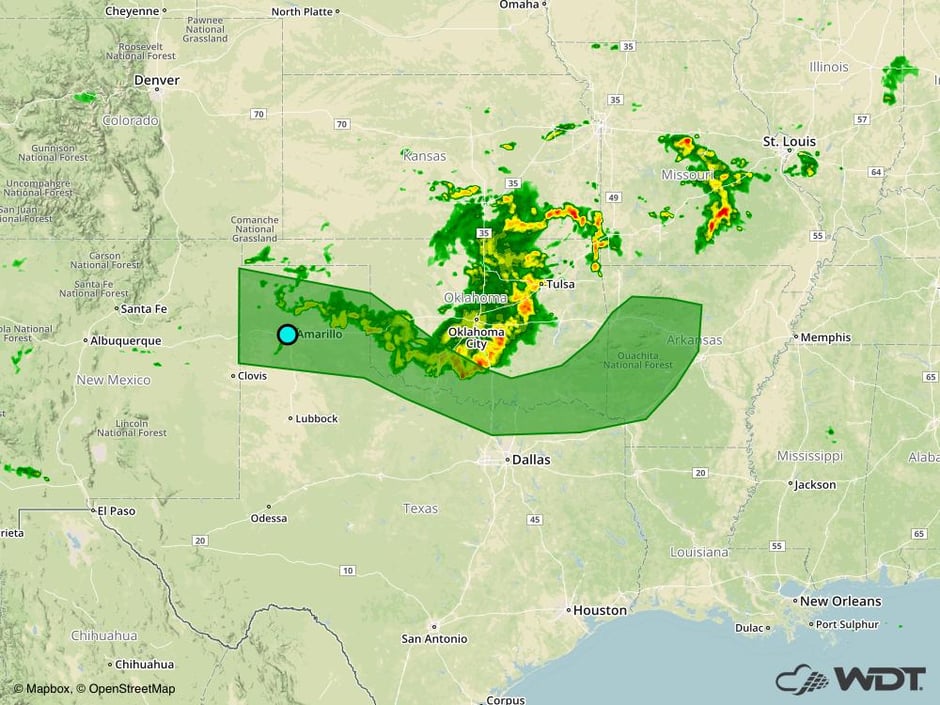 Excessive Rainfall Risk Outline for Friday
Potential for Thunderstorms for the Northern and Central High Plains on Saturday
A short wave trough aloft is forecast to progress to the east across portions of North Dakota and Wyoming into the afternoon on Saturday. With this upper level support, increased dewpoints at the surface along with daytime heating will lead to the development of strong to severe thunderstorms to the east of the surface low and front. Conditions will be favorable for the development of supercell thunderstorms capable of producing strong winds, large hail, and isolated tornadoes.
Major Cities in Region: Cheyenne, WY, North Platte, NE, Bismarck, ND, Pierre, SD
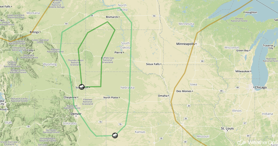 SPC Convective Outlook for Saturday
Thunderstorm Risk Saturday for the Red River
The stationary front is forecast to be along the Red River into Saturday with the front as the focal point for thunderstorm development. With southerly flow and lift along the front, strong to severe thunderstorms may develop during the afternoon. Strong winds will be the primary hazards with these storms. In addition, heavy to excessive rainfall is also forecast. Rainfall amounts of 1.5-2 inches are forecast with locally higher amounts in excess of 3 inches.
Major Cities in Region: Wichita Falls, TX, Ardmore, OK, Texarkana, TX
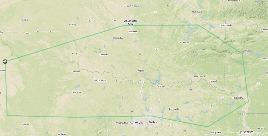 SPC Convective Outlook for Saturday
Thunderstorms for the Northeast on Saturday
As a shortwave trough progresses through the Ohio Valley and into the Northeast on Saturday, strong to severe thunderstorms may develop. Sufficient moisture and lift provided by the front are forecast to be present as well. Any storms that develop will have the potential for strong winds, lightning, and heavy rainfall.
Major Cities in Region: Syracuse, NY, Albany, NY, Burlington, VT
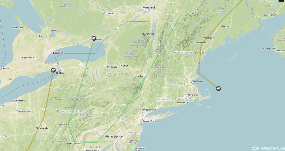 SPC Convective Outlook for Saturday
Continued Excessive Rainfall Sunday across the Southern Plains
The stationary front is forecast to remain over portions of the Southern Plains into Sunday, leading to another day of heavy to excessive rainfall. Rainfall amounts of 1.5-2.0 inches with locally higher amounts in excess of 2.5 inches are forecast. Flooding and flash flooding will continue to be a potential hazard due to previous days' rainfall.
Major Cities in Region: Oklahoma City, OK, Tulsa, OK, Fort Smith, AR, Little Rock, AR, Memphis, TN
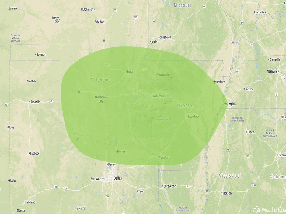 Excessive Rainfall Risk Outline for Sunday
Risk for Thunderstorms for the Central and Southern High Plains on Sunday
Scattered strong to severe thunderstorms are forecast across portions of the High Plains on Sunday. Upper level support will be in place for the development of thunderstorms, with some becoming supercells. Strong winds and large hail will be the primary hazards, but an isolated tornado cannot be ruled out. Supercells will evolve into clusters during the evening and overnight hours.
Major Cities in Region: Cheyenne, WY, Amarillo, TX, Lubbock, TX, North Platte, NE
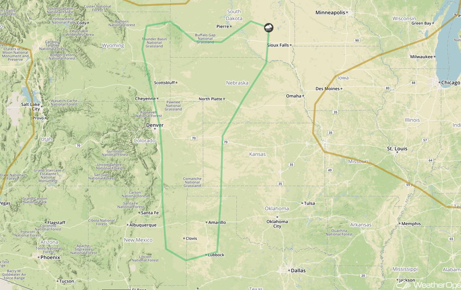 SPC Convective Outlook for Sunday
Thunderstorm Potential Sunday for Maine
The center of low pressure is forecast to remain to the north of the region in the wake of a cold front. Due to westerly flow and an upper level low, isolated strong to severe thunderstorms are forecast across portions of Maine. Strong wind gusts, frequent lightning, and heavy rainfall will be the primary hazards with these storms.
Major Cities in Region: Bangor, ME, Caribou, ME
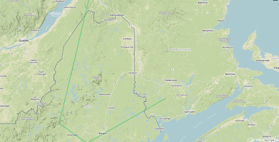 SPC Convective Outlook for Sunday
Tropical Update
An area of disturbed weather centered a couple hundred miles north of the Leeward Islands (red oval) has become a little better organized since yesterday. Upper level winds will become more favorable for development by the weekend, but development may be limited by dry air aloft. This disturbance is expected to move northwestward then northward over the weekend.
A weak area of low pressure just off the east coast of Florida (green oval) is accompanied by disorganized showers and thunderstorms extending from southern Florida northeastward across the southwestern Atlantic. Upper level winds are not favorable for development, but this system could still produce locally heavy rains for portions of Florida as it moves northward over the next day or two.
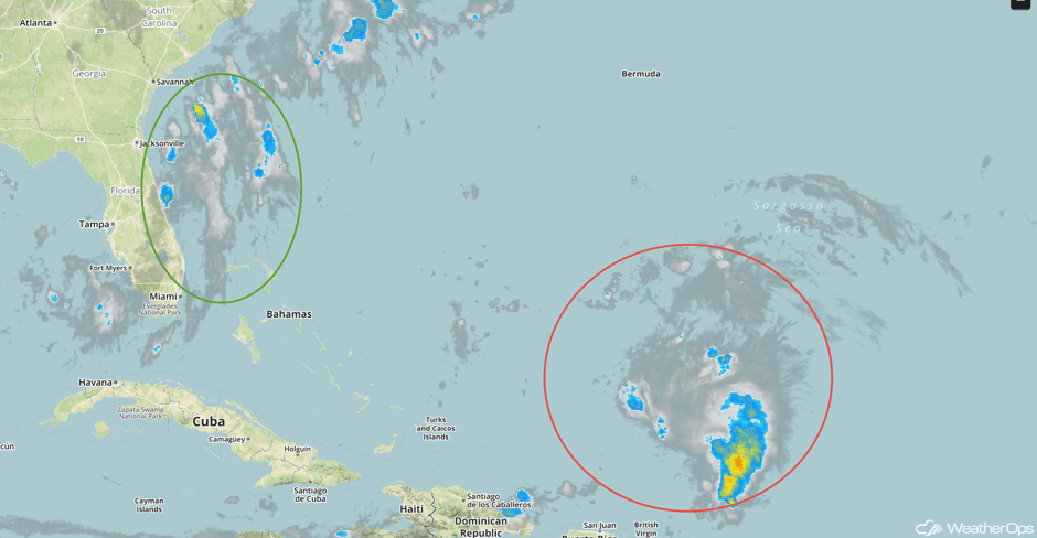 Tropical Enhanced Infrared Satellite
A Look Ahead
A lingering front is forecast to remain throughout portions of the Southern Plains Monday and Tuesday due to continued thunderstorm activity. Two day rainfall totals of 2-3 inches with locally heavier amounts in excess of 4 inches are forecast. Given recent heavy rains, flooding and flash flooding may occur.
This is just a brief look at current weather hazards. We can provide you site-specific weather forecast information for the purpose of protecting your personnel and assets and to assess your weather risk. Try a 7-day demo right away and learn how timely precision weather information can enhance your bottom line.


