by WeatherOps, on Jun 5, 2014 9:39:01 AM

by WeatherOps, on Jun 5, 2014 9:39:01 AM
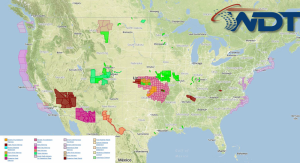
Severe thunderstorms are likely today across the Plains, Mid Mississippi River Valley and Mid South. Large hail, damaging winds, and tornadoes will be possible. Across the Northeast, showers and thunderstorms with some possibly heavy rain will be possible through the early afternoon.
Current NWS Advisories/Watches/Warnings in iMapPro:

The area of low pressure responsible for the severe thunderstorms on Wednesday over the Midwest will move off the East Coast this morning. Ongoing showers will linger across southern New England and the Mid Atlantic through early afternoon. Severe thunderstorms will also be possible across the Central and Southern High Plains. Storms should remain fairly isolated, but any storms that do form will have the potential for large hail and damaging winds. Storms currently over the Southern Plains will continue to push into the Mid South by afternoon. Large hail and damaging winds will be the main threats.
This is where you give the visitor a brief introduction to both this blog and your company. Keep it short. More →