by WeatherOps, on Jun 4, 2014 9:46:09 AM

by WeatherOps, on Jun 4, 2014 9:46:09 AM
Severe thunderstorms will be possible today for portions of the Ohio and Tennessee Valleys; large hail, damaging winds, and tornadoes will be possible. Afternoon and evening thunderstorms will be possible for portions of the Plains.
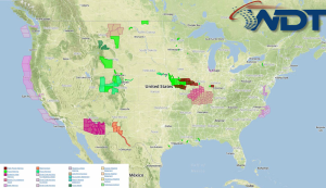
Current NWS Advisories/Watches/Warnings

Thunderstorms are ongoing from the Mid-Mississippi Valley into the Midwest. These storms will move into the Ohio and Tennessee Valleys. While the tornado potential is slightly lower, a few embedded tornadoes will be possible. In addition, over 3 inches of rain will be possible, leading to flash flooding.
Across the Northern and Southern Plains, thunderstorms will be likely this afternoon. Large hail, damaging winds, and isolated tornadoes will be possible. Showers and thunderstorms will be possible over Southern Florida.
This is where you give the visitor a brief introduction to both this blog and your company. Keep it short. More →