by WeatherOps, on Jun 2, 2014 11:58:17 AM

by WeatherOps, on Jun 2, 2014 11:58:17 AM
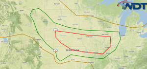
There is a moderate risk for severe weather tomorrow for portions of the Plains.
SPC Convective Outlook for Tuesday

An upper level trough just off the west coast will move into the Central Rockies tomorrow morning. At the surface, a cold front will stall across the Plains. Vertical wind shear of 50 knots or greater and strong instability will allow for the development of severe thunderstorms tomorrow across portions of Nebraska, Kansas, Iowa, and Missouri. As thunderstorms develop, large hail, damaging winds, and tornadoes will be possible. However, as the evening progresses, storms will evolve into a squall line. However, due to the strong shear in place, widespread damaging winds and embedded tornadoes will be possible.
This is where you give the visitor a brief introduction to both this blog and your company. Keep it short. More →