by WeatherOps, on May 28, 2014 9:48:21 AM

by WeatherOps, on May 28, 2014 9:48:21 AM
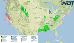
Severe thunderstorms with the potential for hail, damaging winds, and tornadoes will be possible today across portions of the Northern Plains. Across the Southern Plains and Southeast, showers and thunderstorms will continue for portions of the Southern Plains and Southeast.
Current NWS Advisories/Watches/Warnings in iMapPro

An upper level trough will continue progressing through the Deep South. As thunderstorms develop during the morning and afternoon hours, a slight risk for severe thunderstorms will be possible from portions Southeastern Texas into Western Mississippi. Any thunderstorms that develop will have the potential for hail, damaging winds, and tornadoes. Thunderstorms are also possible from portions of Montana through Minnesota. Large hail, damaging winds, and tornadoes will be possible.
Excessive rainfall will continue for much of the Southern US. 1-3.5 inches of rain will be possible. Flooding is likely across the region.
This is where you give the visitor a brief introduction to both this blog and your company. Keep it short. More →