Does the Active Hurricane Season Mean a Warm Winter is Ahead?
by Stephen Strum, on Oct 5, 2017 2:40:28 PM
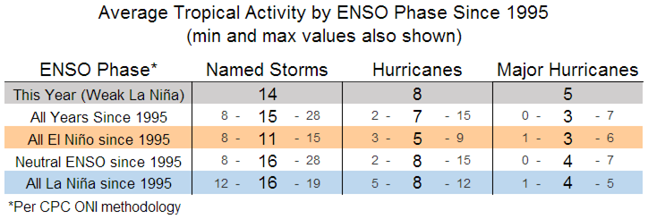
As of early October, the 2017 Atlantic hurricane season has produced 14 named storms, 8 of which have reached hurricane strength, and 5 of those major hurricane status (Category 3 or higher). Regarding storm numbers, this year is still below the average (since 1995) of 16 named storms for both neutral ENSO years and La Niña years (a La Niña is developing this year), but already at the average for hurricanes and one storm ahead of the average for major hurricanes.

Since there are still a few more weeks to go before the season quiets down for the year, we will likely end up near the average regarding storm numbers this year, and likely above the average for hurricanes. More notable is that we have seen some long-lived major hurricanes this year, which has pushed the seasonal ACE index to well above normal levels. The ACE, or Accumulated Cyclone Energy index, essentially combines the number, duration, and intensity of storms into a single index. As of early October, the ACE index for the Atlantic basin in 2017 was 202, good for 6th place all-time. Of the 202 ACE units, 153 of them were the result of just three storms: Irma, Maria, and Jose. If you take out those three storms, the ACE for this year would be running 2nd lowest on record. However, it is not unusual for the ACE index to be dominated each year by a couple of major storms. Note that the highest ever ACE index for a year was 250 in 2005, though it took 28 storms to reach that total in 2005.
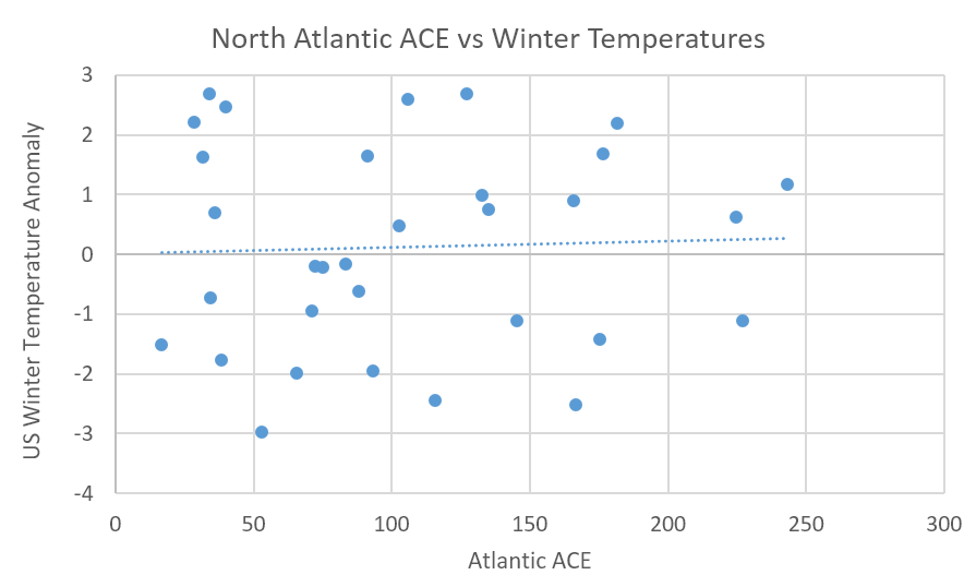
So, does the active hurricane season this year, regarding ACE index, mean anything for the upcoming winter season? Well, not really. The following plot shows US population weighted winter temperatures versus ACE index for the last 30 years or so. The data is scattered quite evenly, with only a very slight positive trend to the data. There does seem to be a tendency for moderately less active hurricane seasons to be followed by colder winters (cold winters seem to dominate when the ACE is between 50-100), but warm winters are only slightly more frequent when the ACE is over 100. So, there may be a slight tendency for warmer winters following a more active hurricane season. However, since active hurricane seasons tend to occur in years when the Atlantic basin is warmer than normal, the warm water temperatures may contribute more to any warming influence than the hurricane activity itself.
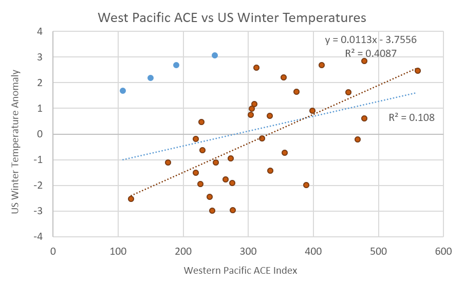
 While there doesn’t seem to be any strong trends between Atlantic hurricane activity and winter temperatures, there is a better correlation between western Pacific typhoon activity and winter temperatures. This following plot shows the same winter temperatures, but versus West Pacific ACE. There is more of a trend between western Pacific typhoon activity and winter temperatures than there is when using Atlantic activity. If the four blue points are excluded, which are large outliers, the correlation is quite significant. The red line shows the trend without the four outliers, and the blue line shows the trend with the outliers included. Once again, how much of the trend is the result of storms versus water temperature trends is not clear as the intensity of winter warmth across the US is strongly tied to Pacific basin water temperatures. Separating out the data by years with above or below normal western Pacific water temperatures has little influence on the trends between ACE and winter temperatures. This year, water temperatures in the region are warmer than normal, but typhoon activity is lower than normal though the typhoon season is far from over in that part of the world.
 It is possible that the distribution of typhoons in the western Pacific, both spatially and regarding the time of year, is essential as well. Numerous late-season typhoons that head to higher latitudes have a much different impact on jet stream patterns than do storms that head into southeastern Asia during the summer. The bottom line is that the details may be more important than the overall yearly averages.
So, in summary, Atlantic hurricane activity seems to have limited impact on winter temperature trends, though cold winters seem to be more frequent when tropical activity is a little below normal. Western Pacific tropical activity appears to have a more significant influence on winter temperature patterns and colder than normal US winters seem to occur more frequently when tropical activity is below normal in that region. However, since the location and intensity of tropical convection in the Pacific (regarding both typhoons and regular thunderstorms) are influenced by ocean temperature patterns and ENSO phase, how much of the influence is directly the result of tropical activity versus the underlying ocean temperature patterns is not certain. But if there is some modulating influence from western Pacific tropical activity, then the below normal activity in that region thus far this year may help to increase the odds for colder weather this winter across the US, at least slightly.


