National Weather Summary for Thursday, April 9, 2015
by WeatherOps, on Apr 9, 2015 9:54:07 AM
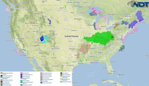
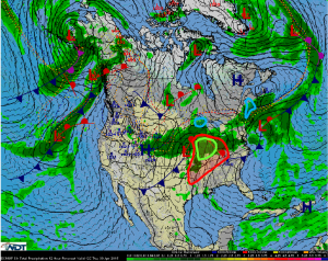
Severe thunderstorms are possible Thursday across the Midwest and Mississippi Valley. Across Upper Michigan, locally heavy snowfall will be possible. A mix of sleet and freezing rain is possible for portions of New England. Heavy rain is possible across the Midwest.
A shortwave trough moving across the Midwest will bring a chance for severe weather from the Midwest to the Arklatex region. The associated cold front will move eastward with strong to severe thunderstorms expected. Damaging winds will be the main concern, but large hail and tornadoes will also be possible. Ongoing activity during the morning from the Kansas and Nebraska border into Texas, and into the Midwest will reintensify by midday or early afternoon. Storms will persist through the overnight hours across the region.
An area of low pressure moving across the Great Lakes will bring snow to Upper Michigan. Some lake effect snow will be possible with accumulations in excess of 6 inches.
A warm front lifting eastward across New England will bring a wintry mix of sleet and freezing rain to portions of New England. As temperatures warm, precipitation will transition to rain, however, further inland, sleet and freezing rain will be possible into the afternoon hours with up to an inch of sleet and a tenth of an inch of ice.
Ongoing shower and thunderstorm activity during the morning will continue for much of the day for portions of Illinois and Indiana. A risk for locally heavy rainfall and potential flooding will continue through Wednesday night.


